File:PIA00170-MC-10-LunaePalusRegion-19980605.jpg
PIA00170-MC-10-LunaePalusRegion-19980605.jpg (800 × 557 pixels, file size: 119 KB, MIME type: image/jpeg)
Summary
PIA00170: MC-10 Lunae Palus Region http://photojournal.jpl.nasa.gov/catalog/pia00170
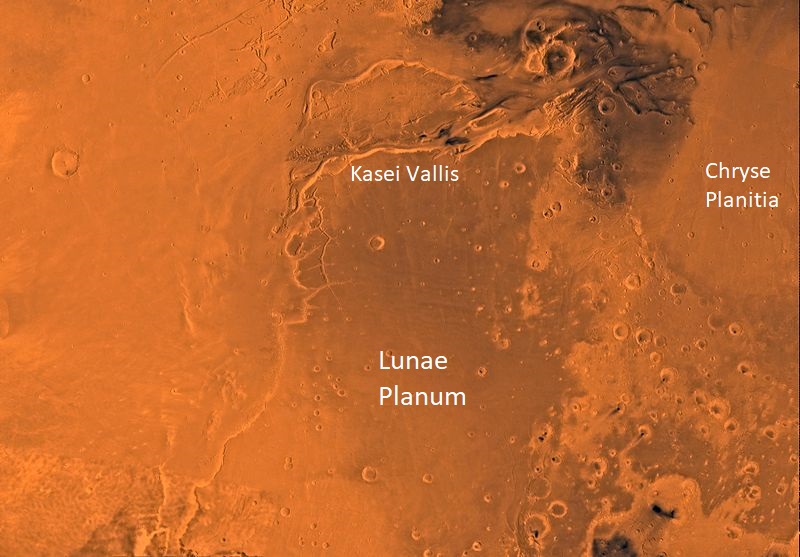
Mars digital-image mosaic merged with color of the MC-10 quadrangle, Lanae Palus region of Mars. The western part is dominated by lava flows of the Tharsis region. The central part includes ridged terrain of Lunae Planum. The west and north borders of Lunae Planum are dissected by the large, relatively young outflow channel, Kasei Vallis, which terminates in Chryse Planitia. Latitude range 0 to 30 degrees, longitude range 45 to 90 degrees.
Source http://photojournal.jpl.nasa.gov/jpeg/PIA00170.jpg
Image credit: NASA/JPL/USGS Other versions Image extraction process This file has an extracted image: File:Aveiro - PIA00170-MC-10-LunaePalusRegion-19980605 (cropped).jpg. Extracted version
Licensing
Public domain images are available for anybody to use without any licenses, royalties, or special permissions.
File history
Click on a date/time to view the file as it appeared at that time.
| Date/Time | Thumbnail | Dimensions | User | Comment | |
|---|---|---|---|---|---|
| current | 09:54, 23 January 2019 | | 800 × 557 (119 KB) | Suitupandshowup (talk | contribs) | PIA00170: MC-10 Lunae Palus Region http://photojournal.jpl.nasa.gov/catalog/pia00170 Mars digital-image mosaic merged with color of the MC-10 quadrangle, Lanae Palus region of Mars. The western part is dominated by lava flows of the Tharsis region. Th... |
You cannot overwrite this file.
File usage
The following page uses this file:


