File:Traverse Near Victoria Sol1215B br.jpg
No higher resolution available.
Traverse_Near_Victoria_Sol1215B_br.jpg (500 × 375 pixels, file size: 33 KB, MIME type: image/jpeg)
Summary
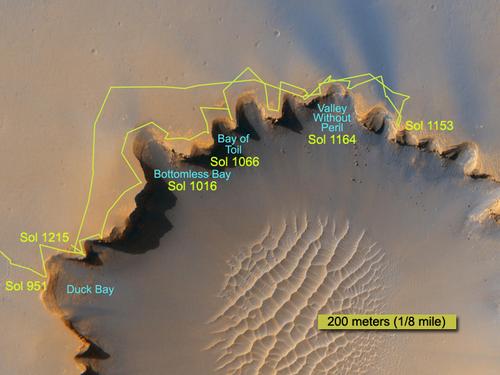
The route followed by NASA's Mars Exploration Rover Opportunity during its exploration partway around the rim of Victoria Crater is marked on this map
Source: https://mars.jpl.nasa.gov/mer/newsroom/pressreleases/20070628a.html
Image credit: Image credit: NASA/JPL/Cornell/University of Arizona/Ohio State University
Licensing
Public domain images are available for anybody to use without any licenses, royalties, or special permissions.
File history
Click on a date/time to view the file as it appeared at that time.
| Date/Time | Thumbnail | Dimensions | User | Comment | |
|---|---|---|---|---|---|
| current | 17:29, 20 December 2018 | | 500 × 375 (33 KB) | Suitupandshowup (talk | contribs) | The route followed by NASA's Mars Exploration Rover Opportunity during its exploration partway around the rim of Victoria Crater is marked on this map Source: https://mars.jpl.nasa.gov/mer/newsroom/pressreleases/20070628a.html Image credit: Image cr... |
You cannot overwrite this file.
File usage
The following page uses this file:


