Difference between revisions of "File:PIA13804-MarsPhoenixLander-Panorama-20080525b.jpg"
(Mars Panorama of Phoenix Landing Site and Lander Deck The full-circle panorama in approximately true color shows the polygonal patterning of ground at the landing area, similar to patterns in permafrost areas on Earth. The center of the image is the...) |
(No difference)
|
Latest revision as of 08:06, 29 March 2018
Summary
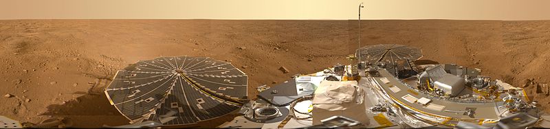
Mars Panorama of Phoenix Landing Site and Lander Deck
The full-circle panorama in approximately true color shows the polygonal patterning of ground at the landing area, similar to patterns in permafrost areas on Earth. The center of the image is the westward part of the scene. Trenches where Phoenix's robotic arm has been exposing subsurface material are visible in the right half of the image. The spacecraft's meteorology mast, topped by the telltale wind gauge, extends into the sky portion of the panorama. Other Phoenix instruments, the lander's deck, and its two solar arrays are also visible. The robotic arm is not in the scene. Source: http://photojournal.jpl.nasa.gov/catalog/PIA13804 Picture credit: NASA/JPL-Caltech/University of Arizona/Texas A&M University
Licensing
Public domain images are available for anybody to use without any licenses, royalties, or special permissions.
File history
Click on a date/time to view the file as it appeared at that time.
| Date/Time | Thumbnail | Dimensions | User | Comment | |
|---|---|---|---|---|---|
| current | 08:06, 29 March 2018 | 800 × 189 (36 KB) | Suitupandshowup (talk | contribs) | Mars Panorama of Phoenix Landing Site and Lander Deck The full-circle panorama in approximately true color shows the polygonal patterning of ground at the landing area, similar to patterns in permafrost areas on Earth. The center of the image is the... |
You cannot overwrite this file.
File usage
The following 2 pages use this file:


