Difference between revisions of "Martian features that are signs of water ice"
(→Ring-Mold Craters: added ref) |
|||
| Line 108: | Line 108: | ||
==Ring-Mold Craters== | ==Ring-Mold Craters== | ||
| − | Ring-mold craters are a kind of impact crater that looks like the ring molds used in baking.<ref>https://link.springer.com/referenceworkentry/10.1007/978-1-4614-9213-9_318-1</ref> They are believed to be caused by an impact into ice. Ice that is covered by a layer of debris. They are found in parts of Mars that have buried ice. Laboratory experiments confirm that impacts into ice result in a "ring mold shape." They are also bigger than other craters in which an asteroid impacted solid rock. Impacts into ice warm the ice and cause it to flow into the ring mold shape. These craters are common in lobate debris aprons and lineated valley fill.<ref>Kress, A., J. Head. 2008. Ring-mold craters in lineated valley fill and lobate debris aprons on Mars: Evidence for subsurface glacial ice. Geophys.Res. Lett: 35. L23206-8</ref> <ref>Baker, D. et al. 2010. Flow patterns of lobate debris aprons and lineated valley fill north of Ismeniae Fossae, Mars: Evidence for extensive mid-latitude glaciation in the Late Amazonian. Icarus: 207. 186-209</ref> <ref>Kress., A. and J. Head. 2009. Ring-mold craters on lineated valley fill, lobate debris aprons, and concentric crater fill on Mars: Implications for near-surface structure, composition, and age. Lunar Planet. Sci: 40. abstract 1379</ref> They may be an easy way for future colonists of Mars to find water ice because some may contain ice that is relatively pure. Also, since the ring-mold was created during a rebound, ice may have been brought up from below the surface so much less digging or drilling may be required to gather ice. | + | Ring-mold craters are a kind of impact crater that looks like the ring molds used in baking.<ref>https://link.springer.com/referenceworkentry/10.1007/978-1-4614-9213-9_318-1</ref>kress, A., J. Head. 2008. Ring‐mold craters in lineated valley fill and lobate debris aprons on Mars: Evidence for subsurface glacial ice. Geophysical Research Letters Volume 35, Issue 23</ref> They are believed to be caused by an impact into ice.<ref>https://agupubs.onlinelibrary.wiley.com/doi/full/10.1029/2008GL035501</ref> <ref> Ice that is covered by a layer of debris. They are found in parts of Mars that have buried ice. Laboratory experiments confirm that impacts into ice result in a "ring mold shape." They are also bigger than other craters in which an asteroid impacted solid rock. Impacts into ice warm the ice and cause it to flow into the ring mold shape. These craters are common in lobate debris aprons and lineated valley fill.<ref>Kress, A., J. Head. 2008. Ring-mold craters in lineated valley fill and lobate debris aprons on Mars: Evidence for subsurface glacial ice. Geophys.Res. Lett: 35. L23206-8</ref> <ref>Baker, D. et al. 2010. Flow patterns of lobate debris aprons and lineated valley fill north of Ismeniae Fossae, Mars: Evidence for extensive mid-latitude glaciation in the Late Amazonian. Icarus: 207. 186-209</ref> <ref>Kress., A. and J. Head. 2009. Ring-mold craters on lineated valley fill, lobate debris aprons, and concentric crater fill on Mars: Implications for near-surface structure, composition, and age. Lunar Planet. Sci: 40. abstract 1379</ref> They may be an easy way for future colonists of Mars to find water ice because some may contain ice that is relatively pure. Also, since the ring-mold was created during a rebound, ice may have been brought up from below the surface so much less digging or drilling may be required to gather ice. |
Revision as of 10:35, 5 February 2019
How to find water on Mars
Article written by Jim Secosky. Jim is a retired science teacher who has used the Hubble Space Telescope, the Mars Global Surveyor, and HiRISE.
INTRODUCTION
Finding sources of water on Mars is necessary for future colonists. Studies with orbiting spacecraft have provided a great deal of evidence pointing to where water ice is located. Decades ago, theoretical studies showed that ice could exist under a cover of material that needed to be very thick near the equator, but at higher latitudes could be right under the surface.[1] Instruments onboard the Mars Odyssey measured the depth to this ice layer all over the planet.

These measurements closely matched what the early theories had predicted. The Phoenix lander’s rockets blew away a thin cover of dirt to reveal the top of an ice layer.[2] Also, by way of frequent pictures from Phoenix, we watched chunks of ice sublimate into the atmosphere. On Mars today, any exposed ice changes directly into a gas and mixes with the atmosphere in the process called sublimation.


We also observed this process through HiRISE photos of ice first being exposed in new craters and then disappearing.

Thanks to the many satellites going around Mars with advanced instruments, we now have a list of features that are signs of easily obtainable underground ice. The shapes of some landscapes are similar to those on the earth that we know contain ice. Radar studies with the SHAllow RADar instrument (SHARD) on board the Mars Reconnaissance Orbiter ( MRO) have found large deposits of ice under relatively thin layers of debris cover for some of these features .[3] [4] The Compact Reconnaissance Imaging Spectrometer for Mars (CRISM) instrument onboard MRO has been able to detect spectroscopic signs of water in certain landscapes. The ice caps contain vast resovors of ice, but traveling to the poles is a long way to go for this precious resource. This article will display many landscapes that probably contain easily obtained water ice that are much closer than the poles.


Contents
Triangular depressions
In early 2018, researchers released information about large amounts of ice found under only a few meters of soil. These places are easily seen as triangular depressions with one steep wall that faces the pole. These exposed ice sheets as thick as 100 meters were discovered by using instruments on board the Mars Reconnaissance Orbiter (MRO). Much evidence of underground ice in vast regions of Mars has already been found by past studies, but this study found that the ice was only covered by a layer of about 1 or 2 meters thick of Martian soil.[5] [6] [7] Shane Byrne, one of the co-authors remarked that future colonists of the Red Planet would be able to gather up ice with just a bucket and shovel.[8] The fact that water-ice makes up the layers was confirmed by Compact Reconnaissance Imaging Spectrometer for Mars (CRISM) on board the Mars Reconnaissance Orbiter (MRO). The spectra gathered by CRISM showed strong signals of water.[9]
The sites are at latitudes from about 55 to 58 degrees north and south of the equator, suggesting that there is shallow ground ice under roughly a third of the Martian surface.[10]
Wide view of triangular depressions with ice under thin cover
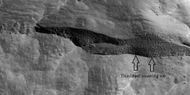
Close view of depression, as seen by HiRISE under HiWish program Arrows indicate where there is a very thin, 1-2 meter covering on what is believed to be ice.


Scalloped topography
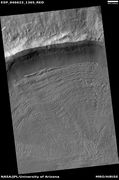
Scalloped topography is common in the mid-latitudes of Mars, between 45° and 60° north and south. It is particularly prominent in the region of Utopia Planitia[11] [12] in the northern hemisphere and in the region of Peneus and Amphitrites Patera in the southern hemisphere.[13] [14] Such topography consists of shallow, rimless depressions with scalloped edges, commonly referred to as "scalloped depressions" or simply "scallops". Scalloped depressions can be isolated or clustered and sometimes seem to coalesce. A typical scalloped depression displays a gentle equator-facing slope and a steeper pole-facing scarp. This topographic asymmetry is probably due to differences in insolation. Scalloped depressions are believed to form from the removal of subsurface material, possibly interstitial ice, by sublimation. Sublimation is where a solid changes directly into a gas without going through a liquid phase. Dry ice on the Earth changes directly to a gas; but usually on Earth, ice will melt first to form a liquid phase before turning into a gas. This process is common in the thin Martian atmosphere. In the fall of 2016, NASA reported finding a large amount of underground ice in the Utopia Planitia region of Mars.[15] The volume of water detected has been estimated to be equivalent to the volume of water in Lake Superior.[16] The volume of water ice in the region were based on measurements from the ground-penetrating radar instrument on Mars Reconnaissance Orbiter, called SHARAD. From the data obtained from SHARAD, a dielectric constant was determined. The dielectric constant value was consistent with a large concentration of water ice.[17] [18] [19]
Scalloped ground, as seen by HiRISE under HiWish program.

Glacial Features
Over the years of satellite observations several features have been observed that look like glacial features that is it looks like ice is flowing under a thin cover of debris. Although ice is not stable at many latitudes of Mars, ice could survive for long periods under a few meters of dirt and rock. Many of these supposed regions of underground ice generally begin around 30 degrees of latitude on both sides of the equator. In other words latitudes greater than 30 degrees may have glaciers.[20] Some bear an uncanny resemblance to alpine or mountain glaciers of the Earth. These, supposed alpine glaciers, have been called glacier-like forms (GLF) or glacier-like flows (GLF). [21] [22] Another, more general term sometimes seen in the literature is viscous flow features (VFF). [23]
Alpine glacier moving from a valley Lat: 42.2° N Long: 50.5° E (309.5 W)
Glacier in Greenland Notice how it resembles the glacier on Mars.
Tongue-shaped glaciers Lat: 35.6° S Long: 109.7° E (250.3 W)


Based on current models of the Martian atmosphere, ice should not be stable if exposed at the surface in the mid-Martian latitudes.[24] It is thus thought that most glaciers must be covered with a layer of rubble or dust preventing free transfer of water vapor from the subliming ice into the air.[25] [26] In the recent geological past, the climate of Mars may have been different in order to allow the glaciers to grow stably at these latitudes.[27] This provides good independent evidence that the obliquity (tilt) of Mars has changed significantly in the past.[28] Evidence for past glaciation also appears on the peaks of several Martian volcanoes in the tropics.[29] [30] [31] For a long time there was some doubt about there actually being glaciers on Mars. However, instruments onboard the Mars Reconnaissance Orbiter confirmed the existence of ice below a shallow cover of debris. So far this ice has been found by the SHAllow RADar (SHARAD) in features called lobate debris aprons (LDA) and lineated valley fill (LVF).[32] [33] Ice was found both in the southern hemisphere [34] and in the northern hemisphere.[35] Researchers at the Niels Bohr Institute concluded that ice in all of the Martian glaciers is equivalent to what could cover the entire surface of Mars with 1.1 meters of ice. [36] [37] [38] In addition to alpine glaciers on Mars, there are other terrains where ice seems to be moving under a few meters of cover.
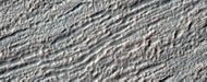
Lineated Valley Fill


Lineated valley fill (LVF) are lines of ridges in valleys.[39] [40] [41] These lines of ridges are thought to have developed as other glaciers moved down valleys.
Lobate Debris Aprons
Lobate debris aprons (LDA) is the name given to glaciers that surround many mesas and buttes. [42] [43] [44] [45]


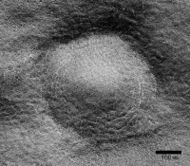
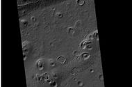
Concentric Crater Fill
Concentric crater fill (CCF) contains dozens to hundreds of concentric ridges that are caused by the movements of sometimes hundreds of meter thick accumulations of ice in craters.[46] [47] The concentric ridges could have been made by the movement of ice away from the walls. Based on topography measures of height in these craters and calculations of how deep the craters should be based on their diameters, it is thought that the craters are 80% filled with mostly ice.[48] [49] [50][51] In other words, these craters hold hundreds of meters of material that probably consists of ice with just a few tens of meters of surface debris.[52] [53] The ice accumulated in the crater from snowfall in previous climates.[54] [55] [56] Concentric crater fill probably develops over many cycles in which snow is deposited, then moves into the crater. Once ice gets inside the crater, shade and a covering of dust preserve it. In time the snow changes to ice. Concentric lines are created by the many separate periods of snow accumulation. Generally snow accumulates whenever the planet’s tilt reaches 35 degrees.[57]
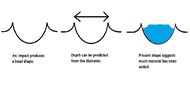
This series of drawings illustrates why researchers believe many craters are full of ice-rich material. The depth of craters can be predicted based upon the observed diameter. Many craters are almost full, instead of having bowl shape; hence it is believed that they have gained much material since they were formed by impact. Much of the extra material is believed to be ice that fell from the sky as snow or ice-coated dust.
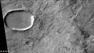
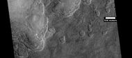
Wide context view of Concentric Crater Fill
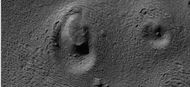
Concentric Crater Fill Lat: 43.1° S Long: 219.8°E (140.2 W)
Close, color view of Concentric Crater Fill


Pingos
Because of the many signs of ground ice, scientists have speculated for years that someday pingos may be found on the planet. Pingos form in ice-rich ground and contain a core of pure ice. “Pingo,” is an Inuit word. Pingos on Mars would be great because they may contain pure water ice. Over the years many mounds have been examined that resemble pingos. However, we may not be sure if they are real pingos until they are examined by rovers. One picture below from HiRISE may be a pingo. The other picture shows how a pingo looks on the Earth. The radial and concentric cracks visible here are common when forces penetrate a brittle layer. These particular fractures were probably created by something emerging from below the brittle Martian surface. Ice may have accumulated under the surface in a lens shape; thus making these cracked mounds. Ice being less dense than rock, pushed upwards on the surface and generated these spider web-like patterns. A similar process creates similar sized mounds in arctic tundra on Earth. [58]
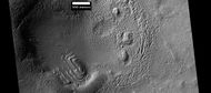
Close view of possible pingo with scale, as seen by HiRISE under HiWish program Lat: 54.7° S Long: 202.7°E (157.3 W)
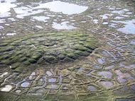
Example of a pingo on Earth. On Earth the ice that caused the pingo would melt and fill the fractures with water; on Mars the ice would turn into a gas in the thin Martian atmosphere.


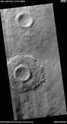
Ring-Mold Craters
Ring-mold craters are a kind of impact crater that looks like the ring molds used in baking.[59]kress, A., J. Head. 2008. Ring‐mold craters in lineated valley fill and lobate debris aprons on Mars: Evidence for subsurface glacial ice. Geophysical Research Letters Volume 35, Issue 23</ref> They are believed to be caused by an impact into ice.[60] Cite error: Closing </ref> missing for <ref> tag [61] [62] They may be an easy way for future colonists of Mars to find water ice because some may contain ice that is relatively pure. Also, since the ring-mold was created during a rebound, ice may have been brought up from below the surface so much less digging or drilling may be required to gather ice.
Note: this is one of the first explanations for ring-mold craters, another has been proposed.

Ring-mold craters form when an impacting object goes through a rock layer to reach ice. The rebound forms the ring-mold shape, and then dust and debris settle on the top which serves to insulate the ice.
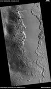
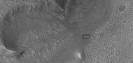
Wide view of a field of ring mold craters, as seen by HiRISE under HiWish program Lat: 34.9° S Long: 105.4° E
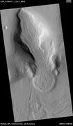
Close view of ring mold crater. Note: this is an enlargement of the previous image of a field of ring mold craters.


Pedestal Craters
A pedestal crater is an impact crater which has its ejecta sitting above the surrounding terrain. This forms a raised platform (like a pedestal). These craters are produced when an impact crater ejects material that forms an erosion-resistant layer, thus causing the immediate area to erode more slowly than the rest of the region. Some pedestals have been accurately measured to be hundreds of meters above the surrounding area. This means that hundreds of meters of material were eroded away. The result is that both the crater and its ejecta blanket stand above the surroundings. Pedestal craters were first observed during the Mariner missions.[63] [64] [65] [66] Much of the material under the pedestal crater may be ice. These may be useful for sources of water ice as these craters can be easily spotted from orbit.
Pedestal crater, as seen by HiRISE under HiWish program . Top layer has protected the lower material from being eroded. Location is Hellas quadrangle, at 52.014° S and 110.651° E

Drawing shows a later idea of how some pedestal craters form. In this way of thinking, an impacting projectile goes into an ice-rich layer—but no further. Heat and wind from the impact hardens the surface against erosion. This hardening can be accomplished by the melting of ice which produces a salt/mineral solution thereby cementing the surface.


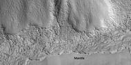
Latitude Dependent Mantle
With the increasing resolution of cameras orbiting Mars, we have discovered that many parts of the planet are covered by a smooth coating that in some cases is layered and quite thick. [67] Some parts are eroded, revealing rough surfaces. Some parts possess layers. It’s generally accepted that mantle is ice-rich dust that fell from the sky as snow and ice-coated dust grains during a different climate [68] Latitude Dependent Mantle and many other supposed ice-rich features occur in two latitude bands in the mid-latitudes; 30-60 degrees North and 30-60 degrees South latitudes. We do not know the exact concentration of ice in the mantle. There may be a little or a lot; maybe the amount varies from place to place. Many places that we believe contain water may require hard drilling to harvest the ice. Perhaps the latitude dependent mantle will not be so hard to extract water from. We know that the mantle does not seem to break up into boulders. Boulders would suggest hard basalt to drill through.
Close view that displays the thickness of the mantle, as seen by HiRISE under HiWish program
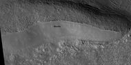
Mantle, as seen by HiRISE under HiWish program
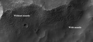
Surface showing appearance with and without mantle covering, as seen by HiRISE, under the HiWish program. Location is Terra Sirenum in Phaethontis quadrangle.


Upper Plains Unit
In many places, it seems that the latitude dependent mantle has accumulated to a substantial thickness. Researchers have called it the “Upper Plains Unit.” This unit can be easily spotted by orbiting satellites by a number of its shapes. Sometimes it displays sets of dipping layers in impact craters, in depressions, and along mesas. It may be 50-100 meters thick, so it may be a source of large amounts of water.[69]
Layered structure in crater that is probably what is left of a layered unit that once covered a much larger area. Material for this unit fell from the sky as ice-coated dust. The picture was taken by HiRISE. Location is Hellas quadrangle, Lat: 41.3° S Long: 116°E

This unit also degrades into brain terrain. Brain terrain is a region of maze-like ridges 3–5 meters high. Some ridges may consist of an ice core, so they may be sources of water for future colonists.
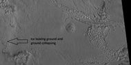
Close view of upper plains unit breaking down into brain terrain, as seen by HiRISE As ice leaves the ground, the ground collapses and winds blow the remaining dust away. Location is Hellas quadrangle.
Close view of brain terrain


In some places the upper plains unit exists as large fractures and troughs with raised rims; these are called ribbed upper plains. Fractures are believed to have started with small cracks from stresses. Cracks expose more surface area, and consequently more ice in the material sublimates into the planet’s thin atmosphere. Eventually, small cracks become large canyons or troughs.
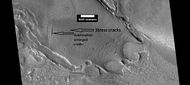
View of stress cracks and larger cracks that have been enlarged by sublimation (ice changing directly into gas) This may be the start of ribbed terrain. Lat: 43.2° N Long: 25.9° E
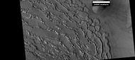
Ribbed terrain Lat: 44° N Long: 26.2°E


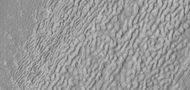
There is one common surface feature that is common to most of these features that contain ice. It is called “brain terrain”. It consists of complex ridges that makes it resemble outside of the human brain. Wide ridges are called closed-cell brain terrain, and the less common narrow ridges are called open-cell brain terrain.[70] It is thought that the wide closed-cell terrain contains a core of ice, and when the ice disappears the center of the wide ridge collapses to produce the narrow ridges of the open-cell brain terrain. Shadow measurements from HiRISE indicate the ridges are 4-5 meters high. Brain terrain has been observed to form from what has been called an "Upper Plains Unit."
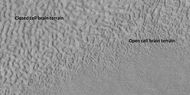
Open and closed brain terrain with labels, as seen by HiRISE Lat: 41.9°N Long: 16.7° E
Brain Terrain to the right. Box shows the size of a football field. Picture taken with HiRISE, under HiWish program.


In summary, brain terrain is found on the surface of glaciers, concentric crater fill, lineated valley fill, lobate debris aprons, and the upper plains unit. The closed cell brain terrain probably contains a core of ice. We do not know the size of this core, but having a surface covered by brain terrain is a clue that much more ice may lie below.
Future research and technology
Although we have strong evidence that Mars had much water in its past and that certain landscapes are signs of water, there is much more to learn before we can start to utilize these resources. Ideally, we would not want to travel too far for our water. The ice found in triangular depressions may be too far. On the other hand water from the mantle and various glacial forms may be much closer, but it may require digging through meters of debris or the materials (in the mantle for example) may only contain a small percentage of water. Consequently, we should develop rovers and penetrators which could sample various features that contain water. This program of looking for ice-rich places should be intensified once we decide where we may want to land. Already, individuals are targeting HiRISE observations at possible manned mission’s sites.[71] Later, we will want to develop robotic machines to mine, process, and deliver ice to the Mars colonists. At least one individual has designed a device that drills for and extracts water from ice-rich ground (check out second external link from the 20th Mars Society Convention). In 2017, there was a nation-wide contest for college students to build such a device.[72] [73]
Appendix
As more and more observations from increasing powerful instruments was gathered, researchers developed ideas to explain the origin of ice rich features on a planet that is very cold and dry. It seems that ice moves from the poles to the mid-latitudes frequently, as the planets tilt changes. Mars undergoes many large changes in its tilt or obliquity because its two small moons lack the gravity to stabilize it, as our moon stabilizes Earth; at times the tilt of Mars has even been greater than 80 degrees[74] [75] When the tilt of Mars reaches 45 degrees from its current 25 degrees, ice is no longer stable at the poles. [76] Furthermore, at this high tilt, stores of solid carbon dioxide (dry ice) sublimate, thereby increasing the atmospheric pressure. This increased pressure allows more dust to be held in the atmosphere. Moisture in the atmosphere will fall as snow or as ice frozen onto dust grains. Models show that this material will concentrate in the mid-latitudes. [77] [78] General circulation models of the Martian atmosphere predict accumulations of ice-rich dust in the same areas where ice-rich features are found. [79] When the tilt begins to return back to lower values, the ice sublimates (turns directly to a gas) and leaves behind a lag of dust. [80] [81] [82] The lag deposit covers the underlying material so with each cycle of high tilt levels, some ice-rich mantle remains behind. [83]
References
- ↑ Rossbacher, L and S. Judson. 1981. Ground Ice on Mars: Inventory, Distribution, and Resulting Landforms. Icarus: 45, 39-59.
- ↑ Smith, P., et al. 2009. H2O at the Phoenix Landing Site. Science: 325, 58-61.
- ↑ Plaut, J., A. Safaeinili, J. Holt, R. Phillips, J. Head, J., R. Seu, N. Putzig, A. Frigeri. 2009. Radar evidence for ice in lobate debris aprons in the mid-northern latitudes of Mars. Geophys. Res. Lett. 36. doi:10.1029/2008GL036379.
- ↑ Holt, J., A. Safaeinili, J. Plaut, J. Head, R. Phillips, R. Seu, S. Kempf, P. Choudhary, D. Young, N. Putzig, D. Biccari, Y. Gim. 2008. Radar sounding evidence for buried glaciers in the southern mid-latitudes of Mars. Science 322. doi:10.1126/science.1164246
- ↑ Steep Slopes on Mars Reveal Structure of Buried Ice. NASA Press Release. 11 January 2018.
- ↑ Ice cliffs spotted on Mars. Science News. Paul Voosen. 11 January 2018.
- ↑ Dundas, E., et al. 2018. Exposed subsurface ice sheets in the martian mid-latitudes. Science. 359. 199.
- ↑ http://spaceref.com/mars/steep-slopes-on-mars-reveal-structure-of-buried-ice.html
- ↑ Colin M. Dundas, et al. Science, 12 January 2018. Vol. 359, Issue 6372, pp. 199-201.
- ↑ Steep Slopes on Mars Reveal Structure of Buried Ice. NASA Press Release. 11 January 2018.
- ↑ Lefort, A.; Russell, P. S.; Thomas, N.; McEwen, A. S.; Dundas, C. M.; Kirk, R. L. 2009. "Observations of periglacial landforms in Utopia Planitia with the High Resolution Imaging Science Experiment (HiRISE)". Journal of Geophysical Research. 114 (E4).
- ↑ Morgenstern, A; Hauber, E; Reiss, D; van Gasselt, S; Grosse, G; Schirrmeister, L (2007). "Deposition and degradation of a volatile-rich layer in Utopia Planitia, and implications for climate history on Mars" (PDF). Journal of Geophysical Research: Planets. 112 (E6): E06010.
- ↑ Zanetti, M.; Hiesinger, H.; Reiss, D.; Hauber, E.; Neukum, G. 2009. "Scalloped Depression Development on Malea Planum and the Southern Wall of the Hellas Basin, Mars" (PDF). Lunar and Planetary Science. 40. p. 2178, abstract 2178.
- ↑ Lefort, A.; Russell, P.S.; Thomas, N. (2010). "Scalloped terrains in the Peneus and Amphitrites Paterae region of Mars as observed by HiRISE". Icarus. 205 (1): 259.
- ↑ http://www.space.com/34811-mars-ice-more-water-than-lake-superior.html
- ↑ "Lake of frozen water the size of New Mexico found on Mars – NASA". The Register. November 22, 2016 name="NASA-20161122"
- ↑ Bramson, A, et al. 2015. Widespread excess ice in Arcadia Planitia, Mars. Geophysical Research Letters: 42, 6566-6574
- ↑ https://planetarycassie.com/2016/11/04/widespread-thick-water-ice-found-in-utopia-planitia-mars/
- ↑ Stuurman, C., et al. 2016. SHARAD detection and characterization of subsurface water ice deposits in Utopia Planitia, Mars. Geophysical Research Letters: 43, 9484_9491.
- ↑ Head, J. W.; et al. (2006). "Extensive valley glacier deposits in the northern mid-latitudes of Mars: Evidence for Late Amazonian obliquity-driven climate change". Earth and Planetary Science Letters. 241 (3): 663–671.
- ↑ Arfstrom, J and W. Hartmann. 2005. Martian flow features, moraine-like ridges, and gullies: Terrestrial analogs and interrelationships. Icarus 174, 321-335.
- ↑ Hubbard B., R. Milliken, J. Kargel , A. Limaye, C. Souness . 2011. Geomorphological characterization and interpretation of a mid-latitude glacier-like form: Hellas Planitia, Mars Icarus 211, 330–346
- ↑ Hubbard B., R. Milliken, J. Kargel , A. Limaye, C. Souness . 2011. Geomorphological characterization and interpretation of a mid-latitude glacier-like form: Hellas Planitia, Mars Icarus 211, 330–346
- ↑ Williams, K. E.; et al. (2008). "Stability of mid-latitude snowpacks on Mars". Icarus. 196 (2): 565–577.
- ↑ Plaut, J.J.; Safaeinili, A.; Holt, J.W.; Phillips, R.J.; Head, J.W.; Sue, R.; Putzig, A. (2009). "Frigeri Radar evidence for ice in lobate debris aprons in the mid-northern latitudes of Mars". Geophys. Res. Lett. 36: L02203.
- ↑ Head, J.; Neukum, G.; Jaumann, R.; Hiesinger, H.; Hauber, E.; Carr, M.; Masson, P.; Foing, B.; et al. (2005). "Tropical to mid-latitude snow and ice accumulation, flow and glaciation on Mars". Nature. 434 (7031): 346–350.
- ↑ Head, J. W.; et al. 2006. "Extensive valley glacier deposits in the northern mid-latitudes of Mars: Evidence for Late Amazonian obliquity-driven climate change". Earth and Planetary Science Letters. 241 (3): 663–671
- ↑ Laskar, Jacques; et al. 2004. "Long term evolution and chaotic diffusion of the insolation quantities of Mars". Icarus. 170 (2): 343–364.
- ↑ Head, J. W.; et al. 2005. "Tropical to mid-latitude snow and ice accumulation, flow and glaciation on Mars". Nature. 434 (7031): 346–351.
- ↑ Shean, David E. 2005. "Origin and evolution of a cold-based tropical mountain glacier on Mars: The Pavonis Mons fan-shaped deposit". Journal of Geophysical Research. 110.
- ↑ Head, James W.; Marchant, David R. (2003). "Cold-based mountain glaciers on Mars: western Arsia Mons". Geology. 31 (7): 641–644.
- ↑ Plaut, J. et al. 2008. Radar Evidence for Ice in Lobate Debris Aprons in the Mid-Northern Latitudes of Mars. Lunar and Planetary Science XXXIX. 2290.
- ↑ http://hirise.lpl.arizona.edu/PSP_009535_2240
- ↑ Holt, J.; Safaeinili, A.; Plaut, J.; Head, J.; Phillips, R.; Seu, R.; Kempf, S.; Choudhary, P.; Young, D.; Putzig, N.; Biccari, D.; Gim, Y. 2008. "Radar sounding evidence for buried glaciers in the southern mid-latitudes of Mars". Science. 322: 1235–1238.
- ↑ Plaut, J.; Safaeinili, A.; Holt, J.; Phillips, R.; Head, J.; Seu, R.; Putzig, N.; Frigeri, A. (2009). "Radar evidence for ice in lobate debris aprons in the mid-northern latitudes of Mars". Geophys. Res. Lett. 36.
- ↑ http://spaceref.com/mars/mars-has-belts-of-glaciers-consisting-of-frozen-water.html
- ↑ http://www.sciencedaily.com/releases/2015/04/150408102701.htm
- ↑ Karlsson, N.; Schmidt, L.; Hvidberg, C. (2015). "Volume of Martian mid-latitude glaciers from radar observations and ice-flow modelling". Geophysical Research Letters. 42: 2627–2633.
- ↑ Carr, M. 2006. The Surface of Mars. Cambridge University Press. ISBN|978-0-521-87201-0
- ↑ Squyres, S. 1978. Martian fretted terrain: Flow of erosional debris. Icarus: 34. 600-613.
- ↑ Levy, J. et al. 2007. Lineated valley fill and lobate debris apron stratigraphy in Nilosyrtis Mensae, Mars: Evidence for phases of glacial modification of the dichotomy boundary. J. Geophys. Res. 112
- ↑ Baker, D., et al. 2009. Flow patterns of lobate debris aprons and lineated valley fill north of Ismeniae Fossae, Mars: Evidence for extensive mid-latitude glaciation in the Late Amazonian. Icarus: 207. 186-209.
- ↑ Marchant, D. and J. Head. 2007. Antarctic dry valleys: Microclimate zonation, variable geomorphic processes, and implications for assessing climatic change on Mars. Icarus: 192.187-222
- ↑ Dickson, J., et al. 2008. Late Amazonian glaciation at the dichotomy boundary on Mars: Evidence for glacial thickness maxima and multiple glacial phases. Geology: 36 (5) 411-415
- ↑ Kress, A., et al. 2006. The nature of the transition from lobate debris aprons to lineated valley fill: Mamers Valles, Northern Arabia Terra-Deuteronilus Mensae region on Mars. Lunar. Planet. Sci. 37. Abstract 1323
- ↑ Garvin, J. et al. 2002. Lunar Planet. Sci: 33. Abstract # 1255.
- ↑ http://photojournal.jpl.nasa.gov/catalog/PIA09662
- ↑ Levy, J., J. Head, D. Marchant. 2010. Concentric Crater fill in the northern mid-latitudes of Mars: Formation process and relationships to similar landforms of glacial origin. Icarus 2009, 390-404.
- ↑ Levy, J., J. Head, J. Dickson, C. Fassett, G. Morgan, S. Schon. 2010. Identification of gully debris flow deposits in Protonilus Mensae, Mars: Characterization of a water-bearing, energetic gully-forming process. Earth Planet. Sci. Lett. 294, 368–377.
- ↑ http://hirise.lpl.arizona.edu/ESP_032569_2225
- ↑ Garvin, J., S. Sakimoto, J. Frawley. 2003. Craters on Mars: Geometric properties from gridded MOLA topography. In: Sixth International Conference on Mars. July 20–25, 2003, Pasadena, California. Abstract 3277.
- ↑ Garvin, J. et al. 2002. Global geometric properties of martian impact craters. Lunar Planet. Sci: 33. Abstract # 1255.
- ↑ http://photojournal.jpl.nasa.gov/catalog/PIA09662
- ↑ Kreslavsky, M. and J. Head. 2006. Modification of impact craters in the northern plains of Mars: Implications for the Amazonian climate history. Meteorit. Planet. Sci.: 41. 1633-1646
- ↑ Madeleine, J. et al. 2007. Exploring the northern mid-latitude glaciation with a general circulation model. In: Seventh International Conference on Mars. Abstract 3096.
- ↑ http://hirise.lpl.arizona.edu/PSP_002917_2175
- ↑ Fastook, J., J.Head. 2014. Concentric crater fill: Rates of glacial accumulation, infilling and deglaciation in the Amazonian and Noachian of Mars. 45th Lunar and Planetary Science Conference (2014) 1227.pdf
- ↑ http://www.uahirise.org/ESP_046359_1250
- ↑ https://link.springer.com/referenceworkentry/10.1007/978-1-4614-9213-9_318-1
- ↑ https://agupubs.onlinelibrary.wiley.com/doi/full/10.1029/2008GL035501
- ↑ Baker, D. et al. 2010. Flow patterns of lobate debris aprons and lineated valley fill north of Ismeniae Fossae, Mars: Evidence for extensive mid-latitude glaciation in the Late Amazonian. Icarus: 207. 186-209
- ↑ Kress., A. and J. Head. 2009. Ring-mold craters on lineated valley fill, lobate debris aprons, and concentric crater fill on Mars: Implications for near-surface structure, composition, and age. Lunar Planet. Sci: 40. abstract 1379
- ↑ http://hirise.lpl.eduPSP_008508_1870
- ↑ Bleacher, J. and S. Sakimoto. Pedestal Craters, A Tool For Interpreting Geological Histories and Estimating Erosion Rates. LPSC
- ↑ http://themis.asu.edu/feature_utopiacraters
- ↑ McCauley, John F. (December 1972). "Mariner 9 Evidence for Wind Erosion in the Equatorial and Mid-Latitude Regions of Mars". Journal of Geophysical Research. 78 (20): 4123–4137(JGRHomepage).
- ↑ Mustard, J., C. Cooper, M. Rifkin. 2001. Evidence for recent climate change on Mars from the identification of youthful near-surface ground ice. Nature 412, 411–414 .
- ↑ Pollack, J., D. Colburn, F. Flaser, R. Kahn, C. Carson, and D. Pidek. 1979. Properties and effects of dust suspended in the martian atmosphere. J. Geophys. Res. 84, 2929-2945.
- ↑ Carr, M. 2001. Mars Global Surveyor observations of martian fretted terrain. J. Geophys. Res. 106, 23571-23593.
- ↑ Levy, J., J. Head, D. Marchant. 2009. Concentric crater fill in Utopia Planitia: History and interaction between glacial “brain terrain” and periglacial mantle processes. Icarus 202, 462–476.
- ↑ https://www.uahirise.org/ESP_053423_2055
- ↑ http://triblive.com/news/education/career/13040517-74/cmu-team-finalist-for-nasas-mars-ice-challenge-to-drill-for-water
- ↑ https://www.nasa.gov/press-release/nasa-s-mars-ice-challenge-follow-the-water
- ↑ name= Touma J. and J. Wisdom. 1993. The Chaotic Obliquity of Mars. Science 259, 1294-1297.
- ↑ Laskar, J., A. Correia, M. Gastineau, F. Joutel, B. Levrard, and P. Robutel. 2004. Long term evolution and chaotic diffusion of the insolation quantities of Mars. Icarus 170, 343-364.
- ↑ Levy, J., J. Head, D. Marchant, D. Kowalewski. 2008. Identification of sublimation-type thermal contraction crack polygons at the proposed NASA Phoenix landing site: Implications for substrate properties and climate-driven morphological evolution. Geophys. Res. Lett. 35. doi:10.1029/2007GL032813.
- ↑ Levy, J., J. Head, D. Marchant. 2009a. Thermal contraction crack polygons on Mars: Classification, distribution, and climate implications from HiRISE observations. J. Geophys. Res. 114. doi:10.1029/2008JE003273.
- ↑ Hauber, E., D. Reiss, M. Ulrich, F. Preusker, F. Trauthan, M. Zanetti, H. Hiesinger, R. Jaumann, L. Johansson, A. Johnsson, S. Van Gaselt, M. Olvmo. 2011. Landscape evolution in Martian mid-latitude regions: insights from analogous periglacial landforms in Svalbard. In: Balme, M., A. Bargery, C. Gallagher, S. Guta (eds). Martian Geomorphology. Geological Society, London. Special Publications: 356. 111-131
- ↑ Laskar, J., A. Correia, M. Gastineau, F. Joutel, B. Levrard, and P. Robutel. 2004. Long term evolution and chaotic diffusion of the insolation quantities of Mars. Icarus 170, 343-364.
- ↑ Mellon, M., B. Jakosky. 1995. The distribution and behavior of Martian ground ice during past and present epochs. J. Geophys. Res. 100, 11781–11799.
- ↑ Mellon, M., B. Jakosky. 1995. The distribution and behavior of Martian ground ice during past and present epochs. J. Geophys. Res. 100, 11781–11799.
- ↑ Schorghofer, N., 2007. Dynamics of ice ages on Mars. Nature 449, 192–194.
- ↑ Madeleine, J., F. Forget, J. Head, B. Levrard, F. Montmessin. 2007. Exploring the northern mid-latitude glaciation with a general circulation model. In: Seventh International Conference on Mars. Abstract 3096.
External links
- Martian Ice - Jim Secosky - 16th Annual International Mars Society Convention
- https://www.youtube.com/watch?v=kpnTh3qlObk T. Gordon Wasilewski - Water on Mars - 20th Annual International Mars Society Convention] Describes how to get water from ice in the ground
- https://www.youtube.com/watch?v=PYl3HXpvqhM Kris Zacny Water on Mars - 21st Annual International Mars Society Convention Describes how to get water from ice in the ground]


