Difference between revisions of "Phoenicis Lacus quadrangle"
m |
m |
||
| Line 29: | Line 29: | ||
Noctis Labyrinthus Viking 1 1980.png|Noctis Labyrinthus, as seen by Viking 1 | Noctis Labyrinthus Viking 1 1980.png|Noctis Labyrinthus, as seen by Viking 1 | ||
| − | |||
| − | + | ||
| + | |||
ESP 049297 1715layersnoctis.jpg|North and south walls of part of Noctis Labyrinthus, as seen by HiRISE under [[HiWish program]] | ESP 049297 1715layersnoctis.jpg|North and south walls of part of Noctis Labyrinthus, as seen by HiRISE under [[HiWish program]] | ||
| − | |||
49297 1715layersclosenorth.jpg|Close view of north wall of part of Noctis Labyrinthus, as seen by HiRISE under HiWish program | 49297 1715layersclosenorth.jpg|Close view of north wall of part of Noctis Labyrinthus, as seen by HiRISE under HiWish program | ||
| Line 42: | Line 41: | ||
<gallery class="center" widths="380px" heights="360px"> | <gallery class="center" widths="380px" heights="360px"> | ||
| − | + | ||
| + | |||
Image:Part_of_Noctis_Labyrinthus_taken_with_the_Mars_Global_Surveyor_-_20060529.jpg|Part of Noctis Labyrinthus taken with Mars Global Surveyor. Courtesy NASA/Malin Space Science Systems. | Image:Part_of_Noctis_Labyrinthus_taken_with_the_Mars_Global_Surveyor_-_20060529.jpg|Part of Noctis Labyrinthus taken with Mars Global Surveyor. Courtesy NASA/Malin Space Science Systems. | ||
| − | Image:Noctis_Labyrinthus.JPG|Layers in the wall of Noctis Labyrinthus taken with [[Mars Global Surveyor]],under the | + | Image:Noctis_Labyrinthus.JPG|Layers in the wall of Noctis Labyrinthus taken with [[Mars Global Surveyor]],under the[MOC Public Targeting Program. Courtesy NASA/Malin Space Science Systems. |
| − | + | ||
| + | |||
Image:25970noctuslayers.jpg|Section of layers near top of Noctis Labyrinthus, as seen by [[HiRISE]] under [[HiWish program]]. | Image:25970noctuslayers.jpg|Section of layers near top of Noctis Labyrinthus, as seen by [[HiRISE]] under [[HiWish program]]. | ||
| − | + | ||
| − | + | ||
| − | |||
| − | |||
| − | |||
Image:26682layersnorth.jpg|Close-up of some layers in wall of Noctis Labyrinthus, as seen by HiRISE under HiWish program. | Image:26682layersnorth.jpg|Close-up of some layers in wall of Noctis Labyrinthus, as seen by HiRISE under HiWish program. | ||
| − | + | ||
| + | |||
Image:ESP_027592_1685close.jpg|Close-up of layers on floor of Noctis Labyrinthus, as seen by HiRISE under HiWish program. This is an enlargement from the center of the previous picture. | Image:ESP_027592_1685close.jpg|Close-up of layers on floor of Noctis Labyrinthus, as seen by HiRISE under HiWish program. This is an enlargement from the center of the previous picture. | ||
Image:28370noctis.jpg|Layers in a section near the top of wall in Noctis Labyrinthus, as seen by HiRISE under HiWish program. | Image:28370noctis.jpg|Layers in a section near the top of wall in Noctis Labyrinthus, as seen by HiRISE under HiWish program. | ||
| − | + | ||
| + | |||
ESP 040093 1665layeredmesa.jpg|Layered mesa on floor of Noctis Labyrinthus, as seen by HiRISE under HiWish program Note: this is an enlargement of a previous image. | ESP 040093 1665layeredmesa.jpg|Layered mesa on floor of Noctis Labyrinthus, as seen by HiRISE under HiWish program Note: this is an enlargement of a previous image. | ||
| − | + | ||
ESP 040093 1665white.jpg|Enlargement of a light-toned structure on floor of Noctis Labyrinthus, as seen by HiRISE under HiWish program Note: this is an enlargement of a previous image. | ESP 040093 1665white.jpg|Enlargement of a light-toned structure on floor of Noctis Labyrinthus, as seen by HiRISE under HiWish program Note: this is an enlargement of a previous image. | ||
| − | + | ||
| − | + | ||
| − | |||
| − | |||
| − | |||
</gallery> | </gallery> | ||
| Line 101: | Line 98: | ||
<gallery class="center" widths="380px" heights="360px"> | <gallery class="center" widths="380px" heights="360px"> | ||
Image:2764streaks.jpg|Image indicates crater cluster and curved lines formed by airblast from meteorites. Meteorites caused airblast which caused dust avalanches on steep slopes. Image is from HiRISE. | Image:2764streaks.jpg|Image indicates crater cluster and curved lines formed by airblast from meteorites. Meteorites caused airblast which caused dust avalanches on steep slopes. Image is from HiRISE. | ||
| − | + | ||
</gallery> | </gallery> | ||
| Line 120: | Line 117: | ||
Image:Oti Fossae.jpg|Oti Fossae, as seen by THEMIS. These parallel graben are found on the northeastern side of Arsia Mons; they are in line with the NE/SW trend of the three volcanoes in Tharsis. | Image:Oti Fossae.jpg|Oti Fossae, as seen by THEMIS. These parallel graben are found on the northeastern side of Arsia Mons; they are in line with the NE/SW trend of the three volcanoes in Tharsis. | ||
Image:Oti Fossae Close-up.JPG|Oti Fossae, as seen by THEMIS. These parallel graben are found on the northeastern side of Arsia Mons; they are in line with the NE/SW trend of the three volcanoes in Tharsis. | Image:Oti Fossae Close-up.JPG|Oti Fossae, as seen by THEMIS. These parallel graben are found on the northeastern side of Arsia Mons; they are in line with the NE/SW trend of the three volcanoes in Tharsis. | ||
| − | + | ||
</gallery> | </gallery> | ||
| Line 128: | Line 125: | ||
<gallery class="center" widths="380px" heights="360px"> | <gallery class="center" widths="380px" heights="360px"> | ||
| − | + | ||
Image:Arsia Mons.JPG|[[Arsia Mons]] showing its position among other volcanoes as seen by THEMIS. | Image:Arsia Mons.JPG|[[Arsia Mons]] showing its position among other volcanoes as seen by THEMIS. | ||
Image:MOLA arsia mons.jpg|Topography around Arsia Mons. | Image:MOLA arsia mons.jpg|Topography around Arsia Mons. | ||
Image:Arsia mons2.jpg|Arsia Mons, as seen by Mars Global Surveyor. | Image:Arsia mons2.jpg|Arsia Mons, as seen by Mars Global Surveyor. | ||
Image:Small Volcano mgs.jpg|Small Volcano in Phoenicis Lacus quadrangle. Image is 1.9 miles wide. | Image:Small Volcano mgs.jpg|Small Volcano in Phoenicis Lacus quadrangle. Image is 1.9 miles wide. | ||
| − | + | ||
Image:24811lavaflowshill.jpg|Lava flows moving around higher ground, as seen by HiRISE under HiWish program | Image:24811lavaflowshill.jpg|Lava flows moving around higher ground, as seen by HiRISE under HiWish program | ||
| − | + | ||
ESP 044840 1620lavaflow.jpg|Edge of lava flow, as seen by HiRISE under HiWish program | ESP 044840 1620lavaflow.jpg|Edge of lava flow, as seen by HiRISE under HiWish program | ||
</gallery> | </gallery> | ||
| Line 153: | Line 150: | ||
<gallery class="center" widths="380px" heights="360px"> | <gallery class="center" widths="380px" heights="360px"> | ||
| − | + | ||
Image:New Impact.JPG|New Impact that formed between March 2000 and July 2003. Scale bar is 500 meters long. Image taken with [[HiRISE]]. | Image:New Impact.JPG|New Impact that formed between March 2000 and July 2003. Scale bar is 500 meters long. Image taken with [[HiRISE]]. | ||
File:ESP 054796 1460channel.jpg|Channel, as seen by HiRISE under HiWish program Arrows indicate position of channel in this rather dark photo. | File:ESP 054796 1460channel.jpg|Channel, as seen by HiRISE under HiWish program Arrows indicate position of channel in this rather dark photo. | ||
Revision as of 10:29, 10 March 2020
| MC-17 | Phoenicis Lacus | 0–30° S | 90–135° W | Quadrangles | Atlas |


The Phoenicis Lacus quadrangle contains a mysterious system of interconnected canyons called Noctis Labyrinthus. In some pictures it looks like a fancy chandelier. The region is part of the great volcanic area known as Tharsis, Tharsis plateau, Tharsis rise, or Tharsis Bulge, it has a large volcano named Arsia Mons and part of another (Pavonis Mons). The names of other parts of this quadrangle are Syria Planum, and Claritas Fossae. The classic regions Daedalia Planum, Sinai Planum, and Solis Planum are found in this quadrangle. Phoenicis Lacus is named after the phoenix which according to myth burns itself up every 500 years and then is reborn.[1] The Phoenicis Lacus quadrangle covers the area from 0° to 30° south latitude and 90° to 135° west longitude (270-225E). The Tharsus rise, which was formed from lava flows, occupies much of area. The volcanoes Pavonis Mons and Arsia Mons are believed to have once had glaciers on them. Glaciers may still exist under a thin layer of rocks.[2] Ice from glaciers can be a source of water for the possible future colonization of the planet.
Besides some giant volcanoes, there are several other interesting features here including lava channels, Dark slope streaks, pits, and large troughs (called fossae). Pits in Zumba Crater are believed to be caused by hot crater ejecta creating steam after falling on ground containing ice. The pits were formed by steam rushing out from groups of pits simultaneously, thereby blowing away from the pit ejecta.[3][4]
Contents
Noctis Labyrinthus
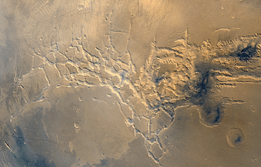
Noctis Labyrinthus is a large canyon system found in the Phoenicis Lacus quadrangle. Its walls contain many layers of rocks. It may be one of the most beautiful and mysterious landscapes on the planet. Pictures below show its location and details in its walls. Research, as early as 2009, found a variety of minerals; including clays, sulfates, and hydrated silica in some of the layers. These minerals are strong evidence for an early presence of water.[5]
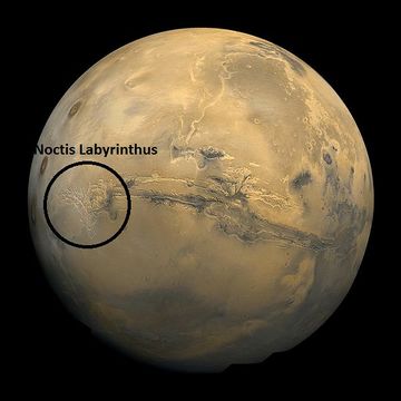
Moasic of Viking 1 Orbiter pictures showing location of Noctus Labyrinthus
Noctis Labyrinthus, as seen by Viking 1

North and south walls of part of Noctis Labyrinthus, as seen by HiRISE under HiWish program

Close view of north wall of part of Noctis Labyrinthus, as seen by HiRISE under HiWish program

Close view of south wall of part of Noctis Labyrinthus, as seen by HiRISE under HiWish program


Part of Noctis Labyrinthus taken with Mars Global Surveyor. Courtesy NASA/Malin Space Science Systems.

Layers in the wall of Noctis Labyrinthus taken with Mars Global Surveyor,under the[MOC Public Targeting Program. Courtesy NASA/Malin Space Science Systems.

Section of layers near top of Noctis Labyrinthus, as seen by HiRISE under HiWish program.

Close-up of some layers in wall of Noctis Labyrinthus, as seen by HiRISE under HiWish program.

Close-up of layers on floor of Noctis Labyrinthus, as seen by HiRISE under HiWish program. This is an enlargement from the center of the previous picture.

Layers in a section near the top of wall in Noctis Labyrinthus, as seen by HiRISE under HiWish program.

Layered mesa on floor of Noctis Labyrinthus, as seen by HiRISE under HiWish program Note: this is an enlargement of a previous image.

Enlargement of a light-toned structure on floor of Noctis Labyrinthus, as seen by HiRISE under HiWish program Note: this is an enlargement of a previous image.


Lava channels
Lava sometimes forms a tube as it moves away from the vent (opening from which lava flows from a volcano). The top of a stream of lava cools down, thereby forming a solid roof. Meanwhile, the lava continues moving in the tube. Often, when all the lava leaves the tube, the roof collapses, making a channel.[6] Lava flows are ubiquitous on Mars. Some can be seen around Pavonis Mons, in the picture below. Some people have suggested that future colonists on Mars could use lava tunnels as shelters. They would offer great protection from radiation, especially Ultraviolet radiation. Lava Channels on the flank of the volcano Pavonis Mons are pictured below in a picture from Mars Odyssey’s THEMIS. Sometimes the lava tube remains intact for a time. Lava will break out along the tube to accumulate or flow away. Lava flows often have a lobate appearance at the edges. A good view of such a lava tube is shown below.

Glaciers
Many of the volcanoes on Mars show strong evidence of past and possible present glacial activity.[7] [8] [9] [10] [11] [12] [13] [14] [15] When glaciers melt and retreat, they leave behind material that was carried in and on the ice. Often the material is dropped in a ridge, called a moraine.[16] An example of moraines is shown in the picture below from the flank of Arsia Mons, a picture taken with Mars Odyssey’s THEMIS.

Ridges on side of Arsia Mons, a large volcano, may be moraines dropped by glacial activity.

Dark slope streaks
A picture below shows Dark slope streaks on Aganippe Fossa. Such streaks are common on Mars. They occur on steep slopes of craters, troughs, and valleys. The streaks are dark at first. They get lighter with age. Sometimes they start in a tiny spot, then spread out and go for hundreds of meters. They have been seen to travel around obstacles, like boulders. It is believed that they are avalanches of bright dust that expose a darker underlying layer. However, several ideas have been advanced to explain them. The streaks appear in areas covered with dust. Much of the Martian surface is covered with dust. Fine dust settles out of the atmosphere covering everything. We know a lot about this dust because the solar panels of the Mars Rovers got covered with dust, which greatly reduced available electrical energy. The power of the Rovers has been restored many times by the wind, in the form of dust devils, cleaning the panels and boosting the power. So, we know that dust settles from the atmosphere then returns over and over.[17] Dust storms are frequent, especially when the spring season begins in the southern hemisphere. At that time, Mars is 40% closer to the sun. The orbit of Mars is much more elliptical then the Earth's. That is the difference between the farthest point from the sun and the closest point to the sun is very great for Mars, but only a slight amount for the Earth. Also, every few years, the entire planet is engulfed in global dust storms. When NASA's Mariner 9 craft arrived there, nothing could be seen through the dust storm.[18] Other global dust storms have also been observed, since that time.

Aganippe Fossa as seen by HiRISE. Full size image shows layers and streaks.

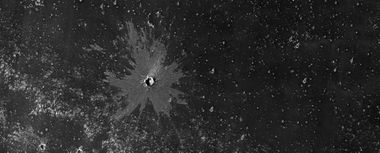
Research that involved streaks in this quadrangle was published in 2012 in the planetary journal Icarus The team found that dark streaks were initiated by airblasts from meteorites traveling at supersonic speeds. After counting some 65,000 dark streaks around the impact site of a group of 5 new craters, patterns emerged. The number of streaks was greatest closer to the impact site. So, the impact somehow probably caused the streaks. Also, the distribution of the streaks formed a pattern with two wings extending from the impact site. The curved wings resembled the curved knives, called scimitars. This pattern suggests that an interaction of airblasts from the group of meteorites shook dust loose enough to start dust avalanches that formed the many dark streaks. At first it was thought that the shaking of the ground from the impact caused the dust avalanches, but if that was the case the dark streaks would have been arranged symmetrically around the impacts, rather than being concentrated into curved shapes. The crater cluster lies near the equator 510 miles) south of Olympus Mons, on a type of terrain called the Medusae Fossae formation. The formation is coated with dust and contains wind-carved ridges called yardangs. These yardangs have steep slopes thickly covered with dust, so when the sonic boom of the airblast arrived from the impacts dust started to move down the slope. Using photos from Mars Global Surveyor and HiRISE camera on NASA's Mars Reconnaissance Orbiter, scientists have found about 20 new impacts each year on Mars. Because the spacecraft have been imaging Mars almost continuously for a span of 14 years, newer images with suspected recent craters can be compared to older images to determine when the craters were formed. Since the craters were spotted in a HiRISE image from February 2006, but were not present in a Mars Global Surveyor image taken in May 2004, the impact occurred in that time frame. The largest crater in the cluster is about 22 m in diameter rand had an area about like that of a basketball court. As the meteorite traveled through the Martian atmosphere it probably broke up; hence a tight group of impact craters resulted. Dark slope streaks have been seen for some time, and many ideas have been advanced to explain them. This research may have finally solved this mystery.[19] [20]

Image indicates crater cluster and curved lines formed by airblast from meteorites. Meteorites caused airblast which caused dust avalanches on steep slopes. Image is from HiRISE.

Pit crater chains
Pit craters are common near volcanoes in both the Tharsis and Elysium system of volcanoes.[21] Pit craters form when a void is produced by a cracking of the surface caused by stretching. Also, lava may drain out of an underground chamber, thus leaving an empty space. When material slides into a void, a pit crater or a pit crater chain forms. Pit craters do not have rims or ejecta around them, like impact craters do. On Mars, individual pit craters can join to form chains or even to form troughs that are sometimes scalloped.[22] Pit craters are not common on Earth. Sinkholes, where the ground falls into a hole (sometimes in the middle of a town) resemble pit craters on Mars. However, on the Earth these holes are caused by limestone being dissolved thereby causing a void.< ref>http://www.msss.com/mars_images/moc/2004/01/29/index.html |title=Mars Global Surveyor MOC2-620 Release |publisher=Msss.com |date=2004-01-29 |</ref> The image below of Arsia Chasmata contains a pit crater chain.

Arsia Chasmata, as seen by HiRISE. A pit crater chain is visible in the lower right.

Fossa on Mars
Certain areas on Mars possess large troughs (long narrow depressions) called fossae in the geographical language used for Mars. This term is derived from Latin; therefore fossa is singular and fossae is plural.[23] Troughs form when the crust is stretched until it breaks. The stretching can be due to the large weight of a nearby volcano. Fossae/pit craters are common near volcanoes in the Tharsis and Elysium system of volcanoes.[24] A trough often has two breaks with a middle section being lower, leaving steep cliffs along the sides; such a trough is called a graben.[25] Lake George, in northern New York State, is a lake that lies in a graben.

Oti Fossae, as seen by HiRISE. Go to Fossa (geology) for more information.

Oti Fossae, as seen by THEMIS. These parallel graben are found on the northeastern side of Arsia Mons; they are in line with the NE/SW trend of the three volcanoes in Tharsis.

Oti Fossae, as seen by THEMIS. These parallel graben are found on the northeastern side of Arsia Mons; they are in line with the NE/SW trend of the three volcanoes in Tharsis.


Volcanoes
The most common form of volcanism on the Earth is basaltic. Basalts formed from molten rocks that cooled on the surface. They originated from the partial melting of the upper mantle. They are rich in the elements iron and magnesium (so they are classified as mafic minerals) and are commonly dark gray in color. The principal type of volcanism on Mars is probably also basaltic.[26] Although Mars displays numerous volcanoes here and other places, there has been no evidence of recent volcanic activity, even at a very low level. Research, from 2017, found no active release of volcanic gases during two successive Martian years. The research team looked for the outgassing of sulfur-bearing chemicals with spectrometers.[27]

Arsia Mons showing its position among other volcanoes as seen by THEMIS.

Topography around Arsia Mons.

Arsia Mons, as seen by Mars Global Surveyor.
Small Volcano in Phoenicis Lacus quadrangle. Image is 1.9 miles wide.

Lava flows moving around higher ground, as seen by HiRISE under HiWish program
Edge of lava flow, as seen by HiRISE under HiWish program


Craters

Crater showing layers and depression on floor, as seen by HiRISE under HiWish program

Close view of layers in crater, as seen by HiRISE under HiWish program

Zumba Crater, as seen by HiRISE. Zumba Crater is a very young crater.

Small crater, as seen by HiRISE under HiWish program Much of the ejecta consists of boulders.
Young crater with bright ejecta in the Phoenicis Lacus quadrangle as seen by HiRISE under HiWish program The impact reached down to a layer that is light-toned. That light-toned material was then deposited on a dark surface.


Other Features in the Phoenicis Lacus quadrangle

New Impact that formed between March 2000 and July 2003. Scale bar is 500 meters long. Image taken with HiRISE.

Channel, as seen by HiRISE under HiWish program Arrows indicate position of channel in this rather dark photo.


Wide view of mounds and lines, as seen by HiRISE under HiWish program The lines may be petrified dunes.

Close, color view of lines from previous image, as seen by HiRISE under HiWish program Here they look like old dunes. Colors show different minerals.


See also
- Dark slope streaks
- Dust devils
- High Resolution Imaging Science Experiment (HiRISE)
- HiWish program
- Mars Global Surveyor
- Mars volcanoes
- Glaciers on Mars
References
- ↑ Blunck, J. 1982. Mars and its Satellites. Exposition Press. Smithtown, N.Y.
- ↑ http://www.mars.asu/christensen/advancedmarsclass/shean_glaciers_2005.pdf
- ↑ Boyce, J. et al. 2012. Origin of small pits in martian impact craters. Icarus. 221: 262-275.
- ↑ Tornabene, L. et al. 2012. Widespread crater-related pitted materials on Mars. Further evidence for the role of target volatiles during the impact process. Icarus. 220: 348-368.
- ↑ https://www.sciencedaily.com/releases/2009/12//091216205910.htm |title=Trough deposits on Mars point to complex hydrologic past |publisher=Sciencedaily.com |date=2009-12-17 |
- ↑ http://themis.asu.edu/zoom-20030821a
- ↑ Scanlon,K., J. Head, D. Marchant. 2015. REMNANT BURIED ICE IN THE ARSIA MONS FAN-SHAPED DEPOSIT, MARS. 46th Lunar and Planetary Science Conference. 2266.pdf
- ↑ Kadish S. J. et al. 2014. PSS, 91, 52-59.
- ↑ Williams R. 1978. Geol. Soc. Am. Abst. with Programs, 10, 517.
- ↑ Lucchitta B. 1981. Icarus, 45(2), 264-303.
- ↑ Head J., D. Marchant. 2003. Geology, 31(7), 641-644.
- ↑ Shean D., et al. 2007. JGR:Planets, 112(E3).
- ↑ Kadish S., et al. 2008. Icarus, 197(1), 84-109.
- ↑ Scanlon K., et al. 2014. Icarus, 237, 315–339.
- ↑ Scanlon K., et al. 2015. Icarus, 250, 18-31.
- ↑ http://themis.asu.edu/zoom-20030827a
- ↑ https://www.sciencedaily.com/releases/2009/02/090217101110.htm |title=Mars Spirit Rover Gets Energy Boost From Cleaner Solar Panels |publisher=Sciencedaily.com |date=2009-02-19 |
- ↑ Hugh H. Kieffer|title=Mars|url=https://books.google.com/books?id=NoDvAAAAMAAJ%7Caccessdate=7 March 2011|date=1992|publisher=University of Arizona Press|isbn=978-0-8165-1257-7
- ↑ Kaylan J. Burleigh, Henry J. Melosh, Livio L. Tornabene, Boris Ivanov, Alfred S. McEwen, Ingrid J. Daubar. Impact air blast triggers dust avalanches on Mars. Icarus, 2012; 217 (1): 194 doi|10.1016/j.icarus.2011.10.026
- ↑ http://redplanet.asu.edu/
- ↑ Skinner, J., L. Skinner, and J. Kargel. 2007. Re-assessment of Hydrovolcanism-based Resurfacing within the Galaxias Fossae Region of Mars. Lunar and Planetary Science XXXVIII (2007)
- ↑ Wyrick, D., D. Ferrill, D. Sims, and S. Colton. 2003. Distribution, Morphology and Structural Associations of Martian Pit Crater Chains. Lunar and Planetary Science XXXIV (2003)
- ↑ http://www.marsartgallery.com/marsnames.html |title=Mars Art Gallery Martian Feature Name Nomenclature |publisher=Marsartgallery.com |date= |
- ↑ Skinner, J., L. Skinner, and J. Kargel. 2007. Re-assessment of Hydrovolcanism-based Resurfacing within the Galaxias Fossae Region of Mars. Lunar and Planetary Science XXXVIII (2007)
- ↑ http://hirise.lpl.arizona.edu/PSP_008641_2105 |title=HiRISE | Craters and Pit Crater Chains in Chryse Planitia (PSP_008641_2105) |publisher=Hirise.lpl.arizona.edu |
- ↑ Carr | first1=Michael H. | publisher=Cambridge University Press | isbn= 978-0-521-87201-0 | title= The Surface of Mars |year=2006 | ref =harv | location=New York
- ↑ Khayat, A., et al. 2017. A deep search for the release of volcanic gases on Mars using ground-based high-resolution infrared and submillimeter spectroscopy: Sensitive upper limits for OCS and SO2. Icarus: 296, 1-14.


