File:PIA19080-MarsRoverCuriosity-AncientGaleLake-Simulated-20141208.jpg
PIA19080-MarsRoverCuriosity-AncientGaleLake-Simulated-20141208.jpg (800 × 500 pixels, file size: 76 KB, MIME type: image/jpeg)
Summary
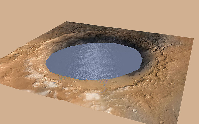
Simulated View of Gale Crater Lake on Mars
http://mars.jpl.nasa.gov/msl/multimedia/images/?ImageID=6875
This simulation depicts a lake partially filling Mars' Gale Crater, receiving runoff from snow melting on the crater's rim. Evidence that NASA's Curiosity rover has found of ancient streams, deltas and lakes suggests the crater held a lake such as this more than three billion years ago.
This illustration depicts a lake of water partially filling Mars' Gale Crater, receiving runoff from snow melting on the crater's northern rim. Evidence of ancient streams, deltas and lakes that NASA's Curiosity Mars rover mission has found in the patterns of sedimentary deposits in Gale Crater suggests the crater held a lake such as this more than three billion years ago, filling and drying in multiple cycles over tens of millions of years.
Gale Crater is 96 miles (154 kilometers) in diameter. This view is looking toward the southeast. The land surface in this illustration is the area's modern shape. Three billion years ago, the rim would have been higher and less eroded. A large layered mountain, Mount Sharp, now stands in the middle of Gale Crater. Accumulation of sediments in lakes, deltas, streams and wind-blown deposits is proposed to have formed the layers making up the lower portion of the mountain. When the crater first held a lake, it might have had central peak, much smaller than Mount Sharp, formed as a rebound from the impact that excavated the crater. Such a peak might have appeared as an island in the lake.
This illustration incorporates portions of a simulated oblique view of Gale Crater (http://photojournal.jpl.nasa.gov/catalog/PIA15292) based on elevation data from the High Resolution Stereo Camera on the European Space Agency's Mars Express orbiter, image data from the Context Camera on NASA's Mars Reconnaissance Orbiter, and color information from Viking Orbiter imagery. The appearance of snow is added as part of the simulation of conditions from billions of years ago. The lake is depicted filling the crater approximately to the elevation where Curiosity found lakebed sediments in the "Pahrump Hills" outcrop at the base of Mount Sharp.
Date 5 December 2014, 14:53:08 Source http://mars.jpl.nasa.gov/msl/images/mars-rover-curiosity-Meyer-Vasavada-Gale-Lake-pia19080-full.jpg
Image credit: NASA/JPL-Caltech/ESA/DLR/FU Berlin/MSS
Licensing
Public domain images are available for anybody to use without any licenses, royalties, or special permissions.
File history
Click on a date/time to view the file as it appeared at that time.
| Date/Time | Thumbnail | Dimensions | User | Comment | |
|---|---|---|---|---|---|
| current | 10:39, 29 December 2018 | | 800 × 500 (76 KB) | Suitupandshowup (talk | contribs) | Simulated View of Gale Crater Lake on Mars http://mars.jpl.nasa.gov/msl/multimedia/images/?ImageID=6875 This simulation depicts a lake partially filling Mars' Gale Crater, receiving runoff from snow melting on the crater's rim. Evidence that NASA's C... |
You cannot overwrite this file.
File usage
The following page uses this file:


