File:Pohloceancomposit.jpg

Size of this preview: 485 × 599 pixels. Other resolutions: 194 × 240 pixels | 918 × 1,134 pixels.
Original file (918 × 1,134 pixels, file size: 360 KB, MIME type: image/jpeg)
Summary
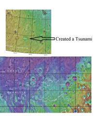
Map showing location of Pohl Crater, the source of the first tsunami in the norther ocean of Mars.
Source: https://asc-planetarynames-data.s3.us-west-2.amazonaws.com/mc11_2014.pdf
Image credit: NASA/USGS/Secosky
Licensing
Public domain images are available for anybody to use without any licenses, royalties, or special permissions.
File history
Click on a date/time to view the file as it appeared at that time.
| Date/Time | Thumbnail | Dimensions | User | Comment | |
|---|---|---|---|---|---|
| current | 16:12, 3 December 2022 | | 918 × 1,134 (360 KB) | Suitupandshowup (talk | contribs) | Map showing location of Pohl Crater, the source of the first tsunami in the norther ocean of Mars. Source: https://asc-planetarynames-data.s3.us-west-2.amazonaws.com/mc11_2014.pdf Image credit: NASA/USGS/Secosky |
You cannot overwrite this file.
File usage
The following page uses this file:


