File:Tharsis Quadrangle map-la.svg

Size of this PNG preview of this SVG file: 800 × 534 pixels. Other resolutions: 320 × 214 pixels | 640 × 428 pixels | 1,024 × 684 pixels | 1,280 × 855 pixels | 1,217 × 813 pixels.
Original file (SVG file, nominally 1,217 × 813 pixels, file size: 489 KB)
Summary
| Description |
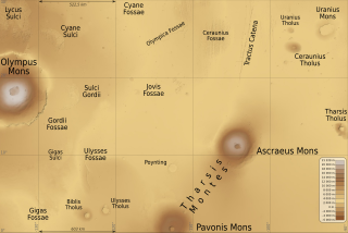
English: Map of Tharsis quadrangle on Mars planet, 90° to 135° west longitude and 0° to 30° north latitude. Latin (also international) version.
Français : Carte du quadrangle de Tharsis sur la planète Mars, de 90° à 135° de longitude ouest et de l'équateur à 30° de latitude nord. Version latine (et aussi internationale). |
| Date | (UTC) |
| Source | |
| Author |
|
| Location on Mars | | View this and other nearby images on: Google Maps |
|---|
This W3C-unspecified vector image was created with Inkscape .
Licensing
I, the copyright holder of this work, hereby publish it under the following licenses:
This file is licensed under the Creative Commons Attribution-Share Alike 4.0 International, 3.0 Unported, 2.5 Generic, 2.0 Generic and 1.0 Generic license.
- You are free:
- to share – to copy, distribute and transmit the work
- to remix – to adapt the work
- Under the following conditions:
- attribution – You must give appropriate credit, provide a link to the license, and indicate if changes were made. You may do so in any reasonable manner, but not in any way that suggests the licensor endorses you or your use.
- share alike – If you remix, transform, or build upon the material, you must distribute your contributions under the same or compatible license as the original.
| This image is in the public domain because it is a screenshot from NASA’s globe software World Wind using a public domain layer, such as Blue Marble, MODIS, Landsat, SRTM, USGS or GLOBE.
|
 |
You may select the license of your choice.
Original upload log
This image is a derivative work of the following images:
- File:Olympus_Mons_Region_map-la.svg licensed with Cc-by-sa-3.0,2.5,2.0,1.0, PD-WorldWind
- 2010-05-31T09:22:21Z Sémhur 2000x1500 (503869 Bytes) Fossea => Fossae
- 2010-05-25T18:26:08Z Sémhur 2000x1500 (493868 Bytes) Oups ! Chevauchement de textes
- 2010-05-25T18:22:39Z Sémhur 2000x1500 (493940 Bytes) Update few labels
- 2010-05-25T15:42:52Z Sémhur 2000x1500 (504578 Bytes) Update altitude max, from http://pubs.usgs.gov/imap/i2782/i2782_sh2.pdf
- 2009-07-08T18:43:58Z Sémhur 2000x1500 (502473 Bytes) * Arcia -> Arsia * Scale
- 2009-07-07T19:59:19Z Sémhur 2000x1500 (502588 Bytes) =={{int:filedesc}}== {{Information |Description= {{en|1=Map of [[:en:Olympus Mons|Olympus Mons]] and [[:en:Tharsis Montes|Tharsis Montes]] region, on Mars planet. Latin (also international) version.}} {{fr|1=Carte de la régi
Uploaded with derivativeFX
File history
Click on a date/time to view the file as it appeared at that time.
| Date/Time | Thumbnail | Dimensions | User | Comment | |
|---|---|---|---|---|---|
| current | 11:59, 2 December 2012 | | 1,217 × 813 (489 KB) | Szczureq | Uranius Patera -> Uranius Mons, Équateur -> 0° |
File usage
The following page uses this file:


