File:The route of 'The Martian' - from Chryse Planitia over Arabia Terra in the Martian highlands to Ares 4.jpg
The_route_of_'The_Martian'_-_from_Chryse_Planitia_over_Arabia_Terra_in_the_Martian_highlands_to_Ares_4.jpg (749 × 599 pixels, file size: 236 KB, MIME type: image/jpeg)
Summary
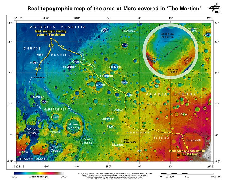
As part of the HRSC experiment on board ESA’s Mars Express spacecraft, scientists from the DLR Institute of Planetary Research have mapped the transition zone between the equator and the northern tropic region topographically. On the map, which contains sheet MC11 east, the route that ‘The Martian’, Mark Watney, travelled on Mars has been illustrated. Before he was able to leave his location at Chryse Planitia for the safety of Ares 4 in Schiaparelli Crater, he had to set up a radio transmitter that he obtained at the landing site of the first Mars rover, Soujourner, which arrived on the Red Planet in 1997 as part of the Mars Pathfinder mission. Sojourner was located a few hundred kilometres to the south of Chryse Planitia. His journey continued to the mouth of Mawrth Vallis, which he drove up and gained about 2000 metres in altitude. Following this, Watney drove an additional 2500 metres uphill through the rough Meridiani Planum, which is littered with craters, to the rim of the 450-kilometre diameter Schiaparelli Crater. On the northwestern rim of the crater, a landslide has created a natural ramp that Watney used to access the crater floor, some 700 metres below, where the the Ares-4 rocket was 'parked'. Date 2 October 2015, 15:13:30 Source https://www.flickr.com/photos/dlr_de/21344671284/ Author ESA/DLR/FU Berlin – CC BY-SA 3.0 IGO
Licensing
Creative Commons Attribution-ShareAlike 4.0 (More Details)
File history
Click on a date/time to view the file as it appeared at that time.
| Date/Time | Thumbnail | Dimensions | User | Comment | |
|---|---|---|---|---|---|
| current | 13:05, 17 January 2019 | | 749 × 599 (236 KB) | Suitupandshowup (talk | contribs) | As part of the HRSC experiment on board ESA’s Mars Express spacecraft, scientists from the DLR Institute of Planetary Research have mapped the transition zone between the equator and the northern tropic region topographically. On the map, which conta... |
You cannot overwrite this file.
File usage
The following page uses this file:


