File:57652 2215exhumed.marspedaijpg.jpg
Revision as of 12:26, 23 February 2020 by Suitupandshowup (talk | contribs) (Exhumed Crater This crater had been buried and now is being uncovered by erosion. Had it just been formed, it would have destroyed part of the formation that is on top of its one side. (ESP_057652_2215) Source: http://hirise.lpl.arizona.edu/ESP_057652_2215 Lat: 41.4° N Long: 46.2° E, Ismenius Lacus quadrangle Image credit is NASA/JPL/University of Arizona.)

Size of this preview: 800 × 314 pixels. Other resolutions: 320 × 126 pixels | 960 × 377 pixels.
Original file (960 × 377 pixels, file size: 65 KB, MIME type: image/jpeg)
Summary
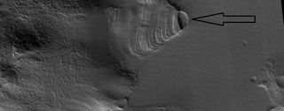
Exhumed Crater This crater had been buried and now is being uncovered by erosion. Had it just been formed, it would have destroyed part of the formation that is on top of its one side. (ESP_057652_2215) Source: http://hirise.lpl.arizona.edu/ESP_057652_2215
Lat: 41.4° N Long: 46.2° E, Ismenius Lacus quadrangle
Image credit is NASA/JPL/University of Arizona.
Licensing
Public domain images are available for anybody to use without any licenses, royalties, or special permissions.
File history
Click on a date/time to view the file as it appeared at that time.
| Date/Time | Thumbnail | Dimensions | User | Comment | |
|---|---|---|---|---|---|
| current | 12:26, 23 February 2020 | 960 × 377 (65 KB) | Suitupandshowup (talk | contribs) | Exhumed Crater This crater had been buried and now is being uncovered by erosion. Had it just been formed, it would have destroyed part of the formation that is on top of its one side. (ESP_057652_2215) Source: http://hirise.lpl.arizona.edu/ESP_057652_2215 Lat: 41.4° N Long: 46.2° E, Ismenius Lacus quadrangle Image credit is NASA/JPL/University of Arizona. |
You cannot overwrite this file.
File usage
The following page uses this file:


