Difference between revisions of "Argyre quadrangle"
Suitupshowup (talk | contribs) (→Channels: added image of channels) |
|||
| (71 intermediate revisions by 2 users not shown) | |||
| Line 12: | Line 12: | ||
File:Argyre region on Mars by the Viking 1 orbiter.jpg | File:Argyre region on Mars by the Viking 1 orbiter.jpg | ||
</gallery>The Argyre quadrangle holds the Argyre basin, a giant impact that occurred 70 million years after the Hellas impact and may have contained a lake in the early history of Mars. | </gallery>The Argyre quadrangle holds the Argyre basin, a giant impact that occurred 70 million years after the Hellas impact and may have contained a lake in the early history of Mars. | ||
| + | |||
| + | |||
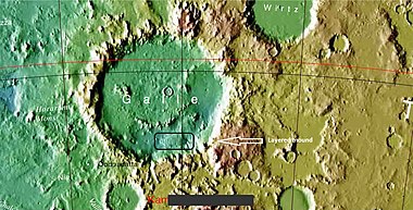
| + | One of the biggest impact basins on Mars is in the Argyre quadrangle. The Argyre quadrangle covers the area from 30° to 65° south latitude and 0° to 60° west longitude (300 -360 E). It contains Galle Crater, which resembles a smiley face. It contains a region on Mars called Argyre Planitia and part of another called Noachis Terra. Noachis is named after Noah in the Bible. This region contains several features that are evidence for ice in the ground. Also, several types of landscapes are very beautiful. These are all discussed and displayed below. Check out the many views from the famous smiley face below. | ||
| + | |||
| + | ==Name== | ||
| + | |||
| + | The word Argyre is named after a legendary silver deposit at the mouth of the Ganges--Arakan, Berma.<ref>Blunck, J. 1982. Mars and its Satellites. Exposition Press. Smithtown, N.Y.</ref> | ||
| + | |||
| + | ==Argyre basin== | ||
| + | |||
| + | The real big feature of the Argyre quadrangle is the Argyre basin, called Argyre Planitia in the geological language of Mars. It was formed by a giant impact that occurred 70 million years after the Hellas impact, the other giant impact in the Southern hemisphere. <ref>Robbins |display-authors=et al | year = 2013 | title = large impact crater histories of Mars: The effect of different model crater age techniques | url = | journal = Icarus | volume = 225 | issue = 1| pages = 173–184 | doi=10.1016/j.icarus.2013.03.019 |</ref> It contained a lake early in the history of Mars.<ref>Parker, T. et al. 2000. Argyre Planitia and the Mars global hydrolocia cycle. LPSC XXXI. Abstract 2033</ref> At least three river valleys (Surius Vallis, Dzigal Vallis, and Palacopus Vallis) drain into it from the south. As soon as water entered the basin, it began to freeze. After it froze solid, the ice formed eskers which are still visible today.<ref>Kargel, J. and R. Strom. 1991. Terrestrial glacial eskers: analogs for martian sinuous ridges. LPSC XXII, 683-684.</ref> <ref>Michael H. Carr|title=The surface of Mars|url=https://books.google.com/books?id=uLHlJ6sjohwC|accessdate=21 March 2011|year=2006|publisher=Cambridge University Press|</ref> Eskers are formed from streams moving under glaciers. Many researchers argue that the impact that formed the Argyre basin probably stuck an ice cap or a thick permafrost layer. That great impact melted the ice and formed a giant lake that eventually sent water to the North. The lake's volume was equal to the Mediterranean Sea. The deepest part of the lake may have taken more than a hundred thousand years to freeze, but with the help of heat from the impact, geothermal heating, and dissolved salts, it may have had liquid water for many millions of years. Life may have developed in this time. This region shows a great deal of evidence of glacial activity with flow features, crevasse-like fractures, drumlines, eskers, tarns, aretes, cirques, Glacial horns, U-shaped valleys, and terraces. | ||
| + | |||
| + | [[File: Argyre MOLA zoom 64.jpg|thumb|500px|center|Topography of the Argyre basin, the major feature in the Argyre quadrangle.]] | ||
| + | |||
| + | ==Galle Crater== | ||
| + | |||
| + | Here are many views of the famous happy face on Mars. Some parts are greatly enlarged with HiRISE images. | ||
| + | |||
| + | |||
| + | [[File: Happy-face1.jpg|thumb|500px|center|Galle Crater, also called Happy-Face Crater, as seen by Mars Global Surveyor]] | ||
| + | |||
| + | <gallery class="center" widths="380px" heights="360px"> | ||
| + | |||
| + | ESP 046684 1280molawide.jpg|Wide view of area around Galle Crater Colors show elevations. | ||
| + | ESP 046684 1280molaclosergalle.jpg|Region around Galle Crater Colors show elevations. | ||
| + | ESP 046684 1280molaclosegalle.jpg|Galle Crater Colors show elevations. Arrow indicates a layered mound that is enlarged in other images to follow. | ||
| + | |||
| + | ESP 046684 1280layerspretty.jpg|HiRISE image from area in previous image Picture taken under HiWish program. | ||
| + | ESP 046684 1280layersprettybottom.jpg|Layers in mound in Galle Crater | ||
| + | ESP 046684 1280layersprettymiddle.jpg|Layers in mound in Galle Crater | ||
| + | |||
| + | 46684 1280polygons.jpg|Layers and polygons in mound in Galle Crater | ||
| + | |||
| + | </gallery> | ||
| + | |||
| + | [[File: 46684 1280mesa.jpg|thumb|300px|left|Layered mesa in mound in Galle Crater, as seen by HiRISE under HiWish program]] | ||
| + | |||
| + | |||
| + | [[File: 46684 1280wall.jpg|thumb|300px|right|Close view of layers in mound in Galle Crater]] | ||
| + | |||
| + | <gallery class="center" widths="380px" heights="360px"> | ||
| + | PSP 003855 1275layerscaptioned.jpg|Unconformities in layers in Galle Crater, as seen by HiRISE Arrows point to some of the unconformities | ||
| + | |||
| + | </gallery> | ||
| + | |||
| + | [[File: 46684 1280breaking.jpg|thumb|500px|center|Layers breaking up into boulders in Galle Crater]] | ||
| + | |||
| + | ==[[Martian gullies]]== | ||
| + | |||
| + | [[File: ESP 040974 1395gullies.jpg|thumb|500px|center|Wide view of gullies in Arkhangelsky Crater, as seen by HiRISE under [[HiWish program]]]] | ||
| + | |||
| + | Gullies are common in some latitude bands on Mars—usually in midlatitudes. Most Martian gullies are found on the walls of craters or troughs, but Charitum Montes, a group of mountains, has gullies in some locations. | ||
| + | |||
| + | Gullies occur on steep slopes, especially on the walls of craters. Gullies are believed to be relatively young because they have few, if any craters. Moreover, they sometimes are on top of sand dunes which themselves are considered to be quite young. Usually, each gully has an alcove, channel, and apron. For many years, researchers thought the gullies were made by running water. But after many more observations it was found that gullies are being formed today which cannot happen with liquid water. <ref>Dundas, C., S. | ||
| + | Diniega, and A. McEwen. 2014. LONG-TERM MONITORING OF MARTIAN GULLY ACTIVITY WITH HIRISE. 45th Lunar and Planetary Science Conference. 2204.pdf</ref> <ref>NASA/Jet Propulsion Laboratory. "NASA orbiter finds new gully channel on Mars." ScienceDaily. ScienceDaily, 22 March 2014. www.sciencedaily.com/releases/2014/03/140322094409.htm </ref> The weather conditions on present day Mars are such that sufficient liquid water cannot exist to cause gullies to form. Experiments on the Earth showed that gullies can be made with the movement of chunks of dry ice moving down steep slope. <ref>http://spaceref.com/mars/frosty-gullies-on-mars.html</ref> Changes in gullies were seen on Mars when the temperature was just right for such movements of dry ice. <ref>Dundas, C., S. Diniega, A. McEwen. 2015. Long-term monitoring of martian gully formation and evolution with MRO/HiRISE. Icarus: 251, 244–263</ref> <ref> last1 = Raack | first1 = J. | display-authors = etal | year = 2015 | title = Present-day seasonal gully activity in a south polar pit (Sisyphi Cavi) on Mars| url = | journal = Icarus | volume = 251 | issue = | pages = 226–243 | doi=10.1016/j.icarus.2014.03.040 | </ref> So, today the scientific community mostly supports the idea that the gullies that are forming today are doing so with dry ice moving down steep slopes. <ref name="NASA-20140710">last=Harrington |first=J.D. |last2=Webster |first2=Guy |title=RELEASE 14-191 – NASA Spacecraft Observes Further Evidence of Dry Ice Gullies on Mars |url=http://www.nasa.gov/press/2014/july/nasa-spacecraft-observes-further-evidence-of-dry-ice-gullies-on-mars |date=July 10, 2014 |work=NASA</ref> <ref>CNRS. "Gullies on Mars sculpted by dry ice rather than liquid water." ScienceDaily. ScienceDaily, 22 December 2015. www.sciencedaily.com/releases/2015/12/151222082255.htm </ref> <ref>http://www.skyandtelescope.com/astronomy-news/martian-gullies-triggered-by-exploding-dry-ice-122320158</ref> However, some concede that liquid water may have been involved in the past. <ref>Dundas, C., S. Diniega, C. Hansen, S. Byrne, A. McEwen. 2012. Seasonal activity and morphological changes in martian gullies. Icarus, 220. 124–143.</ref> | ||
| + | |||
| + | <gallery class="center" widths="380px" heights="360px"> | ||
| + | |||
| + | 47395 1415gullycurvedchannels.jpg|Close view of gullies The channels are quite curved. Because channels of gullies often form curves, it was thought that they were made by flowing water. Today, it is thought that they could be produced with chunks of dry ice. | ||
| + | |||
| + | File:ESP 047963 1305gullies.jpg|Gullies | ||
| + | |||
| + | 47963 1305gullychannelclose.jpg|Close view of gully channel Arrow shows small channel within larger channel. Small channel is quite curved in this image. | ||
| + | </gallery> | ||
| + | |||
| + | [[File: ESP 047528 1355gullies.jpg|thumb|300px|left|Gullies on two sides of a mound]] | ||
| + | |||
| + | [[File: ESP 047395 1415gulliesridges.jpg|thumb|500px|center|Gullies in crater]] | ||
| + | |||
| + | ==Layers== | ||
| + | |||
| + | [[File: ESP 042597 1320layers.jpg|thumb|500px|center|Layers exposed in Nereidum Montes, as seen by HiRISE under [[HiWish program]] The light-toned layers may contain sulfates which are good for preserving traces of ancient life.]] | ||
| + | |||
| + | Some locations in the Argye quadrangle show layers. Many places on Mars show such layers.<ref> Edgett | first1 = Kenneth S. | journal = The Mars Journal | volume = 1 | pages = 5–58|bibcode = 2005IJMSE...1....5E }}</ref> <ref> Malin | first1 = M. P. | last2 = Edgett | first2 = K. S. | date = 2000 | title = Ancient sedimentary rocks of early Mars | url = | journal = Science | volume = 290 | issue = 5498| pages = 1927–1937 | doi = 10.1126/science.290.5498.1927 | pmid = 11110654 |</ref> Finding layered rocks is significant because layered materials usually need water to form. On the Earth most layers have formed under lakes, seas, and oceans. Martian climate changes probably helped greatly in the formation of these layers. These climate variations are due to the tilt of the planet’s rotational axis. Because of these variations of climate, at times the atmosphere of Mars would have been much thicker and contained more moisture. The amount of atmospheric dust also has increased and decreased. It is believed that these frequent changes helped to deposit material in craters and other low places. The rising of mineral-rich ground water cemented these materials. The hardened layers are consequently more protected from erosion. This process may occur instead of layers forming under lakes. | ||
| + | |||
| + | [[File: ESP 048003 1495layers.jpg |thumb|300px|left|Wide view of crater showing layers along wall]] | ||
| + | |||
| + | [[File: 48003 1495layerslight.jpg|thumb|500px|center|Close view of layers in crater wall]] | ||
| + | |||
| + | |||
| + | <gallery class="center" widths="380px" heights="360px"> | ||
| + | |||
| + | ESP 047410 1235layers.jpg|Layers | ||
| + | </gallery> | ||
| + | |||
| + | ==Channels== | ||
| + | |||
| + | [[File: ESP 050243 1425channel.jpg|thumb|500px|center|Channels, as seen by HiRISE under HiWish program]] | ||
| + | |||
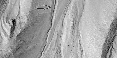
| + | This region, as with many other regions on Mars, shows evidence of water in the past. Well-formed channels are present. There is enormous evidence that water once flowed in river valleys on Mars.<ref>Baker, V., et al. 2015. Fluvial geomorphology on Earth-like planetary surfaces: a review. Geomorphology. 245, 149–182.</ref> <ref>Carr, M. 1996. in Water on Mars. Oxford Univ. Press.</ref> Images of curved channels have been seen in images from Mars spacecraft dating back to the early seventies with the [[Mariner 9]] orbiter.<ref>Baker, V. 1982. The Channels of Mars. Univ. of Tex. Press, Austin, TX</ref><ref>Baker, V., R. Strom, R., V. Gulick, J. Kargel, G. Komatsu, V. Kale. 1991. Ancient oceans, ice sheets and the hydrological cycle on Mars. Nature 352, 589–594.</ref> <ref>Carr, M. 1979. Formation of Martian flood features by release of water from confined aquifers. J. Geophys. Res. 84, 2995–300.</ref> <ref>Komar, P. 1979. Comparisons of the hydraulics of water flows in Martian outflow channels with flows of similar scale on Earth. Icarus 37, 156–181.</ref> The volume of water needed to carve all the channels on Mars was even larger than the proposed ocean that the planet may have had. Water probably left the ocean and fell as rainfall on other places on the planet.<ref>http://spaceref.com/mars/how-much-water-was-needed-to-carve-valleys-on-mars.html</ref> <ref>Luo, W., et al. 2017. New Martian valley network volume estimate consistent with ancient ocean and warm and wet climate. Nature Communications 8. Article number: 15766 (2017). doi:10.1038/ncomms15766</ref> The climate of Mars may have been such in the past that water may have ran on its surface. It has been known for some time that Mars undergoes many large changes in its tilt or obliquity because its two small moons lack the gravity to stabilize it, as our moon stabilizes Earth; at times the tilt of Mars has even been greater than 80 degrees<ref> Touma J. and J. Wisdom. 1993. The Chaotic Obliquity of Mars. Science 259, 1294-1297.</ref> <ref>Laskar, J., A. Correia, M. Gastineau, F. Joutel, B. Levrard, and P. Robutel. 2004. Long term evolution and chaotic diffusion of the insolation quantities of Mars. Icarus 170, 343-364.</ref> | ||
| + | |||
| + | <gallery class="center" widths="380px" heights="360px"> | ||
| + | |||
| + | ESP 047265 1415channel.jpg|Channel, as seen by HiRISE under HiWish program | ||
| + | ESP 048043 1460channel.jpg|Channel, as seen by HiRISE under HiWish program under the HiWish program. This is the image of the surface from a single HiRISE image. The scale bar at the top is 500 meters long. | ||
| + | File:ESP 080141 2170channel 01.jpg|Wide view of channel as seen by HiRISE under HiWish program. Much erosion is visible in places. Since July 23, 2023, HiRISE observations have lacked data from the RED4 CCD due to a hardware issue, creating a gap in the middle of image products. | ||
| + | File:ESP 080141 2170channel 02.jpg|Close view of channel as seen by HiRISE under HiWish program. Much erosion is visible in places. Since July 23, 2023, HiRISE observations have lacked data from the RED4 CCD due to a hardware issue, creating a gap in the middle of image products. | ||
| + | |||
| + | File:ESP 080141 2170channel 03 Erosion through crater.jpg|Channel as seen by HiRISE under HiWish program. Arrow indicates where erosion has cut through a crater. Since July 23, 2023, HiRISE observations have lacked data from the RED4 CCD due to a hardware issue, creating a gap in the middle of image products. | ||
| + | </gallery> | ||
| + | |||
| + | ==Dust devil tracks== | ||
| + | |||
| + | [[File: ESP 048583 1260devilslayers.jpg|thumb|500px|center|Dust devil tracks and layers, as seen by HiRISE under [[HiWish program]]]] | ||
| + | |||
| + | Dust devil tracks can be very pretty. They are caused by giant dust devils removing bright colored dust from the Martian surface; thereby exposing a dark layer. Dust devils on Mars have been photographed both from the ground and high overhead from orbit. They have even blown dust off the solar panels of two Rovers on Mars, thereby greatly extending their useful lifetime.<ref>http://marsrovers.jpl.nasa.gov/gallery/press/spirit/20070412</ref> The pattern of the tracks has been shown to change every few months.<ref>http://hirise.lpl.arizona.edu/PSP_005383_1255</ref> A study that combined data from the High Resolution Stereo Camera (HRSC) and the Mars Orbiter Camera (MOC) found that some large dust devils on Mars have a diameter of 700 m and last at least 26 minutes.<ref>Reiss, D. et al. 2011. Multitemporal observations of identical active dust devils on Mars with High Resolution Stereo Camera (HRSC) and Mars Orbiter Camera (MOC). Icarus. 215:358-369.</ref> | ||
| + | |||
| + | [[File:ESP 048583 1260devilsclosecolor.jpg|thumb|400px|left|Close, color view of dust devil tracks ]] | ||
| + | |||
| + | [[File: ESP 039919 1375devils.jpg|thumb|400px|center|Dust devil tracks]] | ||
| + | |||
| + | ==Dunes== | ||
| + | |||
| + | <gallery class="center" widths="380px" heights="360px"> | ||
| + | File:ESP 057445 1385dunes.jpg|Wide view of small dune field, as seen by HiRISE under HiWish program | ||
| + | |||
| + | File:57445 1385dunesclose.jpg|Close view of dunes Ripples are visible on the dunes. | ||
| + | |||
| + | File:Dune field in ESP 033272 1400 01.jpg|Field of dunes as seen by HiRISE | ||
| + | File:Small group of dunes.jpg|Close view of group of dunes, as seen by HiRISE under HiWish program | ||
| + | File:Single dune in Argyre quadrangle.jpg|Single dune | ||
| + | |||
| + | </gallery> | ||
| + | |||
| + | == Other features in Argyre quadrangle== | ||
| + | |||
| + | [[File: ESP 048280 1395hollows.jpg|thumb|500px|center|Hollows, as seen by HiRISE under [[HiWish program]]]] | ||
| + | |||
| + | |||
| + | [[File:ESP 054570 1465pingos.jpg|thumb|500px|left|Possible pingos Pingos contain a core of ice. They are expected to have cracks on their surfaces because water expands when it turns into ice.]] | ||
| + | |||
| + | |||
| + | [[File:55453 1250icetroughs.jpg|thumb|400px|center|Close view of polygons with ice in troughs between polygons]] | ||
| + | |||
| + | ==See Also== | ||
| + | |||
| + | *[[Dust devils]] | ||
| + | *[[Geography of Mars]] | ||
| + | *[[High Resolution Imaging Science Experiment (HiRISE)]] | ||
| + | *[[HiWish program]] | ||
| + | |||
| + | *[[Layers on Mars]] | ||
| + | *[[Mars Global Surveyor]] | ||
| + | |||
| + | *[[Periodic climate changes on Mars]] | ||
| + | *[[Rivers on Mars]] | ||
| + | |||
| + | *[[Water]] | ||
| + | |||
| + | ==External links== | ||
| + | |||
| + | *https://planetarynames.wr.usgs.gov/Page/MARS/target For information on names and locations on Mars | ||
| + | |||
| + | * [https://www.youtube.com/watch?v=NiT02piO40c The Geological History of Water on Mars and Astrobiological Implications (Vic Baker)] (50:10) | ||
| + | |||
| + | * [https://www.youtube.com/watch?v=RWNXJk0Y01k The Evolution of Water on Mars (Stephen Clifford)] (1:22) (2017) | ||
| + | |||
| + | |||
| + | ==References== | ||
| + | {{reflist|colwidth=30em}} | ||
| + | |||
[[Category: Mars Atlas]] | [[Category: Mars Atlas]] | ||
Latest revision as of 07:07, 20 February 2024
| MC-26 | Argyre | 30–65° S | 0–60° W | Quadrangles | Atlas |


The Argyre quadrangle holds the Argyre basin, a giant impact that occurred 70 million years after the Hellas impact and may have contained a lake in the early history of Mars.
One of the biggest impact basins on Mars is in the Argyre quadrangle. The Argyre quadrangle covers the area from 30° to 65° south latitude and 0° to 60° west longitude (300 -360 E). It contains Galle Crater, which resembles a smiley face. It contains a region on Mars called Argyre Planitia and part of another called Noachis Terra. Noachis is named after Noah in the Bible. This region contains several features that are evidence for ice in the ground. Also, several types of landscapes are very beautiful. These are all discussed and displayed below. Check out the many views from the famous smiley face below.
Contents
Name
The word Argyre is named after a legendary silver deposit at the mouth of the Ganges--Arakan, Berma.[1]
Argyre basin
The real big feature of the Argyre quadrangle is the Argyre basin, called Argyre Planitia in the geological language of Mars. It was formed by a giant impact that occurred 70 million years after the Hellas impact, the other giant impact in the Southern hemisphere. [2] It contained a lake early in the history of Mars.[3] At least three river valleys (Surius Vallis, Dzigal Vallis, and Palacopus Vallis) drain into it from the south. As soon as water entered the basin, it began to freeze. After it froze solid, the ice formed eskers which are still visible today.[4] [5] Eskers are formed from streams moving under glaciers. Many researchers argue that the impact that formed the Argyre basin probably stuck an ice cap or a thick permafrost layer. That great impact melted the ice and formed a giant lake that eventually sent water to the North. The lake's volume was equal to the Mediterranean Sea. The deepest part of the lake may have taken more than a hundred thousand years to freeze, but with the help of heat from the impact, geothermal heating, and dissolved salts, it may have had liquid water for many millions of years. Life may have developed in this time. This region shows a great deal of evidence of glacial activity with flow features, crevasse-like fractures, drumlines, eskers, tarns, aretes, cirques, Glacial horns, U-shaped valleys, and terraces.

Galle Crater
Here are many views of the famous happy face on Mars. Some parts are greatly enlarged with HiRISE images.


Wide view of area around Galle Crater Colors show elevations.

Region around Galle Crater Colors show elevations.
Galle Crater Colors show elevations. Arrow indicates a layered mound that is enlarged in other images to follow.

HiRISE image from area in previous image Picture taken under HiWish program.
Layers in mound in Galle Crater

Layers in mound in Galle Crater

Layers and polygons in mound in Galle Crater


Unconformities in layers in Galle Crater, as seen by HiRISE Arrows point to some of the unconformities


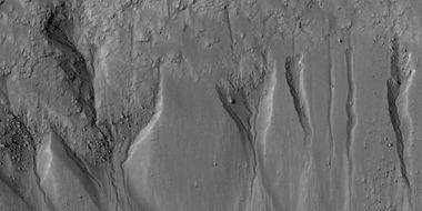
Martian gullies

Gullies are common in some latitude bands on Mars—usually in midlatitudes. Most Martian gullies are found on the walls of craters or troughs, but Charitum Montes, a group of mountains, has gullies in some locations.
Gullies occur on steep slopes, especially on the walls of craters. Gullies are believed to be relatively young because they have few, if any craters. Moreover, they sometimes are on top of sand dunes which themselves are considered to be quite young. Usually, each gully has an alcove, channel, and apron. For many years, researchers thought the gullies were made by running water. But after many more observations it was found that gullies are being formed today which cannot happen with liquid water. [6] [7] The weather conditions on present day Mars are such that sufficient liquid water cannot exist to cause gullies to form. Experiments on the Earth showed that gullies can be made with the movement of chunks of dry ice moving down steep slope. [8] Changes in gullies were seen on Mars when the temperature was just right for such movements of dry ice. [9] [10] So, today the scientific community mostly supports the idea that the gullies that are forming today are doing so with dry ice moving down steep slopes. [11] [12] [13] However, some concede that liquid water may have been involved in the past. [14]
Close view of gullies The channels are quite curved. Because channels of gullies often form curves, it was thought that they were made by flowing water. Today, it is thought that they could be produced with chunks of dry ice.
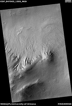
Gullies
Close view of gully channel Arrow shows small channel within larger channel. Small channel is quite curved in this image.


Layers

Some locations in the Argye quadrangle show layers. Many places on Mars show such layers.[15] [16] Finding layered rocks is significant because layered materials usually need water to form. On the Earth most layers have formed under lakes, seas, and oceans. Martian climate changes probably helped greatly in the formation of these layers. These climate variations are due to the tilt of the planet’s rotational axis. Because of these variations of climate, at times the atmosphere of Mars would have been much thicker and contained more moisture. The amount of atmospheric dust also has increased and decreased. It is believed that these frequent changes helped to deposit material in craters and other low places. The rising of mineral-rich ground water cemented these materials. The hardened layers are consequently more protected from erosion. This process may occur instead of layers forming under lakes.


Layers

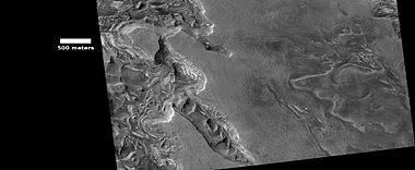
Channels

This region, as with many other regions on Mars, shows evidence of water in the past. Well-formed channels are present. There is enormous evidence that water once flowed in river valleys on Mars.[17] [18] Images of curved channels have been seen in images from Mars spacecraft dating back to the early seventies with the Mariner 9 orbiter.[19][20] [21] [22] The volume of water needed to carve all the channels on Mars was even larger than the proposed ocean that the planet may have had. Water probably left the ocean and fell as rainfall on other places on the planet.[23] [24] The climate of Mars may have been such in the past that water may have ran on its surface. It has been known for some time that Mars undergoes many large changes in its tilt or obliquity because its two small moons lack the gravity to stabilize it, as our moon stabilizes Earth; at times the tilt of Mars has even been greater than 80 degrees[25] [26]

Channel, as seen by HiRISE under HiWish program
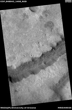
Channel, as seen by HiRISE under HiWish program under the HiWish program. This is the image of the surface from a single HiRISE image. The scale bar at the top is 500 meters long.

Wide view of channel as seen by HiRISE under HiWish program. Much erosion is visible in places. Since July 23, 2023, HiRISE observations have lacked data from the RED4 CCD due to a hardware issue, creating a gap in the middle of image products.

Close view of channel as seen by HiRISE under HiWish program. Much erosion is visible in places. Since July 23, 2023, HiRISE observations have lacked data from the RED4 CCD due to a hardware issue, creating a gap in the middle of image products.

Channel as seen by HiRISE under HiWish program. Arrow indicates where erosion has cut through a crater. Since July 23, 2023, HiRISE observations have lacked data from the RED4 CCD due to a hardware issue, creating a gap in the middle of image products.


Dust devil tracks

Dust devil tracks can be very pretty. They are caused by giant dust devils removing bright colored dust from the Martian surface; thereby exposing a dark layer. Dust devils on Mars have been photographed both from the ground and high overhead from orbit. They have even blown dust off the solar panels of two Rovers on Mars, thereby greatly extending their useful lifetime.[27] The pattern of the tracks has been shown to change every few months.[28] A study that combined data from the High Resolution Stereo Camera (HRSC) and the Mars Orbiter Camera (MOC) found that some large dust devils on Mars have a diameter of 700 m and last at least 26 minutes.[29]


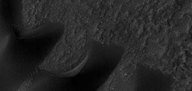
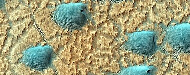
Dunes

Wide view of small dune field, as seen by HiRISE under HiWish program
Close view of dunes Ripples are visible on the dunes.

Field of dunes as seen by HiRISE
Close view of group of dunes, as seen by HiRISE under HiWish program

Single dune


Other features in Argyre quadrangle


See Also
External links
- https://planetarynames.wr.usgs.gov/Page/MARS/target For information on names and locations on Mars
- The Evolution of Water on Mars (Stephen Clifford) (1:22) (2017)
References
- ↑ Blunck, J. 1982. Mars and its Satellites. Exposition Press. Smithtown, N.Y.
- ↑ Robbins |display-authors=et al | year = 2013 | title = large impact crater histories of Mars: The effect of different model crater age techniques | url = | journal = Icarus | volume = 225 | issue = 1| pages = 173–184 | doi=10.1016/j.icarus.2013.03.019 |
- ↑ Parker, T. et al. 2000. Argyre Planitia and the Mars global hydrolocia cycle. LPSC XXXI. Abstract 2033
- ↑ Kargel, J. and R. Strom. 1991. Terrestrial glacial eskers: analogs for martian sinuous ridges. LPSC XXII, 683-684.
- ↑ Michael H. Carr|title=The surface of Mars|url=https://books.google.com/books?id=uLHlJ6sjohwC%7Caccessdate=21 March 2011|year=2006|publisher=Cambridge University Press|
- ↑ Dundas, C., S. Diniega, and A. McEwen. 2014. LONG-TERM MONITORING OF MARTIAN GULLY ACTIVITY WITH HIRISE. 45th Lunar and Planetary Science Conference. 2204.pdf
- ↑ NASA/Jet Propulsion Laboratory. "NASA orbiter finds new gully channel on Mars." ScienceDaily. ScienceDaily, 22 March 2014. www.sciencedaily.com/releases/2014/03/140322094409.htm
- ↑ http://spaceref.com/mars/frosty-gullies-on-mars.html
- ↑ Dundas, C., S. Diniega, A. McEwen. 2015. Long-term monitoring of martian gully formation and evolution with MRO/HiRISE. Icarus: 251, 244–263
- ↑ last1 = Raack | first1 = J. | display-authors = etal | year = 2015 | title = Present-day seasonal gully activity in a south polar pit (Sisyphi Cavi) on Mars| url = | journal = Icarus | volume = 251 | issue = | pages = 226–243 | doi=10.1016/j.icarus.2014.03.040 |
- ↑ last=Harrington |first=J.D. |last2=Webster |first2=Guy |title=RELEASE 14-191 – NASA Spacecraft Observes Further Evidence of Dry Ice Gullies on Mars |url=http://www.nasa.gov/press/2014/july/nasa-spacecraft-observes-further-evidence-of-dry-ice-gullies-on-mars |date=July 10, 2014 |work=NASA
- ↑ CNRS. "Gullies on Mars sculpted by dry ice rather than liquid water." ScienceDaily. ScienceDaily, 22 December 2015. www.sciencedaily.com/releases/2015/12/151222082255.htm
- ↑ http://www.skyandtelescope.com/astronomy-news/martian-gullies-triggered-by-exploding-dry-ice-122320158
- ↑ Dundas, C., S. Diniega, C. Hansen, S. Byrne, A. McEwen. 2012. Seasonal activity and morphological changes in martian gullies. Icarus, 220. 124–143.
- ↑ Edgett | first1 = Kenneth S. | journal = The Mars Journal | volume = 1 | pages = 5–58|bibcode = 2005IJMSE...1....5E }}
- ↑ Malin | first1 = M. P. | last2 = Edgett | first2 = K. S. | date = 2000 | title = Ancient sedimentary rocks of early Mars | url = | journal = Science | volume = 290 | issue = 5498| pages = 1927–1937 | doi = 10.1126/science.290.5498.1927 | pmid = 11110654 |
- ↑ Baker, V., et al. 2015. Fluvial geomorphology on Earth-like planetary surfaces: a review. Geomorphology. 245, 149–182.
- ↑ Carr, M. 1996. in Water on Mars. Oxford Univ. Press.
- ↑ Baker, V. 1982. The Channels of Mars. Univ. of Tex. Press, Austin, TX
- ↑ Baker, V., R. Strom, R., V. Gulick, J. Kargel, G. Komatsu, V. Kale. 1991. Ancient oceans, ice sheets and the hydrological cycle on Mars. Nature 352, 589–594.
- ↑ Carr, M. 1979. Formation of Martian flood features by release of water from confined aquifers. J. Geophys. Res. 84, 2995–300.
- ↑ Komar, P. 1979. Comparisons of the hydraulics of water flows in Martian outflow channels with flows of similar scale on Earth. Icarus 37, 156–181.
- ↑ http://spaceref.com/mars/how-much-water-was-needed-to-carve-valleys-on-mars.html
- ↑ Luo, W., et al. 2017. New Martian valley network volume estimate consistent with ancient ocean and warm and wet climate. Nature Communications 8. Article number: 15766 (2017). doi:10.1038/ncomms15766
- ↑ Touma J. and J. Wisdom. 1993. The Chaotic Obliquity of Mars. Science 259, 1294-1297.
- ↑ Laskar, J., A. Correia, M. Gastineau, F. Joutel, B. Levrard, and P. Robutel. 2004. Long term evolution and chaotic diffusion of the insolation quantities of Mars. Icarus 170, 343-364.
- ↑ http://marsrovers.jpl.nasa.gov/gallery/press/spirit/20070412
- ↑ http://hirise.lpl.arizona.edu/PSP_005383_1255
- ↑ Reiss, D. et al. 2011. Multitemporal observations of identical active dust devils on Mars with High Resolution Stereo Camera (HRSC) and Mars Orbiter Camera (MOC). Icarus. 215:358-369.


