Difference between revisions of "Coprates quadrangle"
(greatly added to topic with pictures, text, ref) |
|||
| Line 14: | Line 14: | ||
</gallery> | </gallery> | ||
[[Category: Mars Atlas]] | [[Category: Mars Atlas]] | ||
| + | |||
| + | |||
| + | The Coprates Quadrangle contains perhaps the most outstanding feature on Mars—the Valles Marineris chasma system, a set of canyons that would stretch across the United States. | ||
| + | [[File:Valles Marineris PIA00178.jpg|thumb|300px|Image of the Coprates Quadrangle (MC-18). The prominent [[Valles Marineris]] chasma system intersects the moderately cratered northern part and the faulted highland ridged plains in the southern part.]] The '''Coprates [[quadrangle (geography)|quadrangle]]''' is one of a series of [[list of quadrangles on Mars|30 quadrangle maps of Mars]] used by the [[United States Geological Survey]] (USGS) [[Astrogeology Research Program]]. The Coprates quadrangle is also referred to as MC-18 (Mars Chart-18).<ref>Davies, M.E.; Batson, R.M.; Wu, S.S.C. "Geodesy and Cartography" in Kieffer, H.H.; Jakosky, B.M.; Snyder, C.W.; Matthews, M.S., Eds. ''Mars.'' University of Arizona Press: Tucson, 1992.</ref> | ||
| + | ==Location and name== | ||
| + | The '''Coprates quadrangle''' goes from 0° to 30° south latitude and 45° to 90° west longitude (315-270 E). Coprates quadrangle is famous for depicting the "Grand Canyon of Mars", the Valles Marineris Canyon System. Impressive signs of water exist in this quadrangle, with ancient river valleys and networks of stream channels showing up as inverted terrain and lakes inside of Valles Marineris.<ref name="Cabrol, N 2010">Cabrol, N. and E. Grin (eds.). 2010. Lakes on Mars. Elsevier. NY</ref> | ||
| + | The Coprates quadrangle contains parts of many of the old classical regions of Mars: Sinai Planum, Solis Planum, Thaumasia Planum, Lunae Planum, Noachis Terra, and Xanthe Terra. Because Mars has a very thin, clear atmosphere astronomers have been able to see surface markings for hundreds of years. Early observers gave names to them—many from old names from the Bible or old writings. | ||
| + | The name Coprates refers to an old name for a river in Persia.<ref>Blunck, J. 1982. Mars and its Satellites. Exposition Press. Smithtown, N.Y.</ref> The river is the Dez River, a tributary of the Karun in modern Iran. Water from the Dez eventually empties into the Shatt al-Arab near its Persian Gulf estuary. The name was approved by the International Astronomical Union (IAU) in 1958.<ref> "Coprates quadrangle". Gazetteer of Planetary Nomenclature. USGS Astrogeology Research Program.</ref> <ref> Smith, William, ed. (1854). "Dictionary of Greek and Roman Geography". Perseus Digital Library. Tufts University. Retrieved 6 Dec 2016.</ref> | ||
| + | == Valles Marineris canyon system == | ||
| + | [[Valles Marineris]] is the largest canyon system in the solar system; this great canyon would go almost all the way across the United States. This section describes the system with words; pictures in this article also show all these features/names.The name for the whole system of canyons is Valles Marineris. Starting at the west with [[Noctis Labyrinthus]] in the [[Phoenicis Lacus quadrangle]], the canyon system ends in the [[Margaritifer Sinus quadrangle]] with Capri Chasma and Eos Chasma (in the south). The word Chasma has been designated by the International Astronomical Union to refer to an elongate, steep-sided depression. Valles Marineris was discovered by and named for the Mariner 9 mission. Moving east from Noctis Labyrinthus, the canyon splits into two troughs, named Tithonium Chasma and Ius Chasma (in the south). In the middle of the system are the very wide valleys of Ophir Chasma (north), Candor Chasma, and Melas Chasma (south). Going farther to the east, one comes to Coprates Chasma. At the end of Coprates Chasma, the valley gets wider to form Capri Chasma in the north and Eos Chasma in the south. The walls of the canyons often contain many layers. The floors of some of the canyons contain large deposits of layered materials. The layers may have formed when water once filled the canyons.<ref> Cabrol, N. and E. Grin (eds.). 2010. Lakes on Mars. Elsevier. NY</ref> <ref>McCauley, J. 1978. Geologic map of the Coprates quadrangle of Mars. U.S. Geol. Misc. Inv. Map I-897</ref><ref>{{cite journal | last1 = Nedell | first1 = S. | display-authors = etal | year = 1987 | title = Origin and evolution of the layered deposits in the Valles Marineris, Mars | url = | journal = Icarus | volume = 70 | issue = 3| pages = 409–441 | doi=10.1016/0019-1035(87)90086-8 | </ref> <ref>Weitz, C. and T. Parker. 2000. New evidence that the Valles Marineris interior deposits formed in standing bodies of water. LPSC XXXI. Abstract 1693</ref> The canyons are deep as well as long; in places they are 8-10 kilometers deep, much deeper than the Earth's Grand Canyon, which is only 1.6 kilometers deep.<ref>Hugh H. Kieffer|title=Mars|url=https://books.google.com/books?id=NoDvAAAAMAAJ|accessdate=7 March 2011|year=1992|publisher=University of Arizona Press|</ref> | ||
| + | |||
| + | <gallery class="center" widths="190px" heights="180px" > | ||
| + | Mars Valles Marineris.jpeg|Wide view of Mars centered on Valles Marineris, taken with Viking images Note, this picture will greatly enlarge by clicking on it several times. | ||
| + | |||
| + | Image:Coprates map.JPG|Map of Coprates quadrangle showing details of [[Valles Marineris]], the largest canyon system in the solar system. Some of the canyons may have once been filled with water. | ||
| + | Image:Melas Chasma.JPG|[[Melas Chasma]], as seen by THEMIS. Click on image to see relationship of Melas Chasma to other features. | ||
| + | Image:Cliff in Candor Chasma.JPG|Cliff in [[Candor Chasma]] Plateau, as seen by THEMIS. Click on image to see relationship with other features in Coprates quadrangle. | ||
| + | Image:Ganges Chasma.JPG|Cliff in northern wall of [[Ganges Chasma]], as seen by THEMIS. Click on image to see relationship with other features in the Coprates quadrangle. | ||
| + | </gallery> | ||
| + | |||
| + | ==Interior layered deposits and sulfate== | ||
| + | This quadrangle, as indeed many other quadrangles of Mars, show much evidence of vast amounts of water in the past. Some features like old stream beds clearly point toward a water-rich past for Mars. However, layered features and their chemistry, although not as striking, provide great support for large amounts of water in the past. | ||
| + | Parts of the floors of Candor Chasma and Juventae Chasma contain layered deposits that have been given the name interior layered deposits (ILD's) and Equatorial Layered Deposits (ELD's). These layers may have formed when the whole area was a giant lake. However, many other ideas have been advanced to explain them.<ref> Cabrol, N. and E. Grin (eds.). 2010. Lakes on Mars. Elsevier. NY</ref> > High-resolution structural and geologic mapping in west Candor Chasma, presented in March 2015, showed that the deposits on the floor of the Candor Chasma are basin filling sediments that were deposited in a wet playa like setting; hence water was involved in their formation.<ref>Okubo, C. 2015. HIGH-RESOLUTION STRUCTURAL AND GEOLOGIC MAPPING IN CANDOR CHASMA. 46th Lunar and Planetary Science Conference. 1210.pdf</ref> | ||
| + | Some places on Mars contain hydrated sulfate deposits, including ILD's. Sulfate formation involves the presence of water. The European Space Agency's Mars Express found possible evidence of the sulfates epsomite and kieserite. Sulfates that contain water are found in many places on the planet. Usually, they show up in pictures as light-toned materials. These are in striking contrast to the widespread dark volcanic surfaces. Scientists want to visit these areas with robotic rovers.<ref>http://themis.asu.edu/features/candorchasma |title=Bath Salts in Candor Chasma? | Mars Odyssey Mission THEMIS |publisher=Themis.asu.edu |</ref> | ||
| + | These deposits have been found to contain ferric oxides in the form of crystalline grey hematite.<ref> Cabrol, N. and E. Grin (eds.). 2010. Lakes on Mars. Elsevier. NY</ref> <ref> Christensen | first1 = P. | display-authors = etal | year = 2001 | title = Global mapping of Martian hematite mineral deposits: Remnants of water-driven processes on early Mars | url = | journal = J. Geophys. Res. | volume = 106 | issue = E10| pages = 23873–23885 | doi=10.1029/2000je001415 |</ref> <ref>Weitz | first1 = C. | display-authors = etal | year = 2008 | title = Gray hematite distribution and formation in Ophir and Candor Chasmata | url = | journal = J. Geophys. Res. | volume = 113 | issue = E2| page = E02016 | doi=10.1029/2007je002930 |</ref> Grey hematite is another sign of water as it usually forms with the aid of water. | ||
| + | |||
| + | == Layers == | ||
| + | Perhaps, the best location to view layers on Mars is in the Coprates quadrangle. This is probably because of so many huge, deep canyons that display layer after layer in their walls. Images of rocks in the canyon walls almost always show layers.<ref>Grotzinger, J. and R. Milliken. 2012. Sedimentary Geology of Mars. SEPM.</ref> Layered rocks have different characteristics. Some layers appear tougher than others. In the image below of Ganges Chasma Layers, as seen by HiRISE, one can see that the upper, light-toned deposits are eroding much faster than the lower darker layers. Some cliffs on Mars show a few darker layers standing out and often breaking into large pieces; these are thought to be hard volcanic rock instead of soft ash deposits. An example of hard layers is shown below in the picture of layers in the canyon wall in Coprates, as seen by [[Mars Global Surveyor]]. Because of its closeness to the Tharsis volcanic region, rock layers may be made of layer after layer of lava flows, probably mixed with deposits of volcanic ash that fell out of the air following big eruptions. Rock strata visible in the walls preserve a long geological history of Mars.<ref>http://themis.asu.edu/features/coprateschasma |title=Landslides and Debris in Coprates Chasma | Mars Odyssey Mission THEMIS |publisher=Themis.asu.edu |date= |</ref> The Earth does not possess long records of geological history since plate tectonics erases rock materials at more or less regular intervals. Dark layers in canyon walls may be due to dark lava flows. The dark volcanic rock basalt dominates the Martian surface. However, light-toned deposits appear in many spots, and those deposits may have resulted from rivers, lakes, volcanic ash, or windblown deposits of sand or dust.<ref>http://hirise.lpl.arizona.edu/PSP_005385_1640 |title=HiRISE | Light-toned Layers in Eos Chaos (PSP_005385_1640) |publisher=Hirise.lpl.arizona.edu |date= |</ref> The Mars Rovers found light-toned rocks to contain sulfates. Probably having been formed in water, sulfate deposits are of great interest to scientists because they may contain traces of ancient life.<ref>http://hirise,lpl.arizona.edu/PSP_007430_1725</ref> | ||
| + | <gallery class="center" widths="190px" heights="180px" > | ||
| + | Image:Ganges Chasma Layers.JPG|[[Ganges Chasma]] Layers, as seen by [[HiRISE]]. | ||
| + | Image:Coprates layers.JPG|Layers in the canyon wall in Coprates, as seen by [[Mars Global Surveyor]], under the [[MOC Public Targeting Program]]. | ||
| + | Image:ESP 026997 1660 RED abrowse.jpg|Wide view of layers in wall of [[Valles Marineris]], as seen by HiRISE under [[HiWish program]]. | ||
| + | Image:26997layersclose.jpg|Close-up of layers in wall of Valles Marineris, as seen by HiRISE under HiWish program. | ||
| + | Image:26997steep.jpg|Part of wall of Valles Marineris, as seen by HiRISE under HiWish program. | ||
| + | Image:26997steepclose.jpg|Close-up of part of previous image of wall of Valles Marineris, as seen by HiRISE under HiWish program. | ||
| + | ESP 043376 1710layers.jpg|Layers in trough south of Ius Chasma, as seen by HiRISE under HiWish program | ||
| + | 43376 1710layersclose.jpg|Close up of layers in trough south of Ius Chasma, as seen by HiRISE under HiWish program Note: this is enlargement of the previous image using HiView | ||
| + | Image:Layers in Monument Valley.jpg|Layers in Monument Valley. These are accepted as being formed, at least in part, by water deposition. Since Mars contains similar layers, water remains as a major cause of layering on Mars. | ||
| + | Image:Juventae Chasma Layers.JPG|Layers west of [[Juventae Chasma]], as seen by HiRISE. Scale bar is 500 meters long. | ||
| + | Image:Orson Welles Crater.JPG|[[Orson Welles Crater]], as seen by HiRISE. Layered, light-toned rocks seem to be under a dark mantling material. Layers may be sandstone, volcanic ash, or lakebed deposits. | ||
| + | Image:Corprates Chasma Fault.JPG|[[Corprates Chasma]] [[fault (geology)|Fault]], as seen by HiRISE. Layers in the rock face may be from volcanic, lacustrine, and/or aeolian sediments deposited in [[Valles Marineris]]. | ||
| + | Image:Ritchey Crater.JPG|[[Ritchey Crater]] layers, as seen by HiRISE. The dark cap layer seems to be resistant to erosion, while the white middle layer is weak. Click on image to see more details. Scale bar is 500 meters long. | ||
| + | Image:Eos Chaos.jpg|Light colored layers in [[Eos Chaos]], as seen by [[HiRISE]]. | ||
| + | Image:Melas Chasma Layered Deposits.JPG|Two views of [[Melas Chasma]] Layered Deposits, as seen by HiRISE. Left picture lies north of other picture on the right. Pictures are not the same scale. Click on image to see details of layers. | ||
| + | Image:Tithonium Chasma Layers.JPG|[[Tithonium Chasma]] Layers, as seen by HiRISE. | ||
| + | Image:25177dunesandlayers.jpg|Layers and dark dunes on the floor of a crater, as seen by HiRISE under the [[HiWish program]]. Groundwater may have risen up in the crater and cemented sediments with minerals. | ||
| + | ESP 047187 1725layers.jpg|Wide view of layers south of Ius Chasma, as seen by HiRISE under HiWish program | ||
| + | 47187 1725layers.jpg|Close view of layers south of Ius Chasma, as seen by HiRISE under HiWish program Note: this is an enlargement of the previous wide view. | ||
| + | 47187 1725layers2.jpg|Close view of layers south of Ius Chasma, as seen by HiRISE under HiWish program Note: this is an enlargement of a previous wide view. | ||
| + | </gallery> | ||
| + | <gallery class="center" widths="190px" heights="180px" > | ||
| + | ESP 048057 1560crater.jpg|Layers near top of crater wall, as seen by HiRISE under HiWish program | ||
| + | 48057 1560craterlayersclose.jpg|Close view of layers near top of crater wall, as seen by HiRISE under HiWish program | ||
| + | </gallery> | ||
| + | <gallery class="center" widths="190px" heights="180px" > | ||
| + | ESP 048980 1725layers.jpg|Wide view of layers in [[Louros Valles]], as seen by HiRISE under HiWish program Louros Valles is part of the [[Ius Chasma]]. | ||
| + | 48980 1725layersclose2.jpg|Close view of layers in Louros Valles, as seen by HiRISE under HiWish program Note this is an enlargement of a previous image. | ||
| + | 48980 1725layers.jpg|Close view of layers in Louros Valles, as seen by HiRISE under HiWish program Note this is an enlargement of a previous image. | ||
| + | 48980 1725layersclose.jpg|Close view of layers in Louros Valles, as seen by HiRISE under HiWish program Note this is an enlargement of a previous image. | ||
| + | ESP 048980 1725layersclosecolor.jpg|Close view of layers in Louros Valles, as seen by HiRISE under HiWish program Note this is an enlargement of a previous image. | ||
| + | </gallery> | ||
| + | ==Hebes Chasma and hydrated deposits== | ||
| + | Hebes Chasma, a large enclosed valley, may have once held water. Hydrated minerals have been found there. It is thought that large-scale underground springs of groundwater at different times burst to the surface to form deposits called Light Toned Deposits (LTD's). Some suggest present or fossilized life forms may be found there because the deposits are relatively young.<ref>[http://www.universetoday.com/2008/12/11/Groundwater May Have Played Important Role in Shaping Mars]</ref> | ||
| + | ==Nirgal Vallis and sapping== | ||
| + | [[Nirgal Vallis]] is one of the longest valley networks on Mars. It is so large that it is found on more than one quadrangle. Scientists do not know how all the ancient river valleys were formed. There is evidence that instead of rain or snow, the water that formed the valleys originated underground. One mechanism that has been advanced is groundwater sapping.<ref>http://themis.asu.edu/zoom-20030916a</ref> In the process of sapping, the ground just gives away as water comes out. Sapping is common in some desert areas in America's Southwest. Sapping forms alcoves and stubby tributaries. These features are visible in the picture below of Nigal Vallis taken with [[Mars Odyssey]]'s THEMIS. | ||
| + | ==Great flood in Holden Crater== | ||
| + | Water from Nirgal Vallis contributed to a great flood that went through the rim of [[Holden Crater]] and helped form a lake in the crater. It's estimated that [[Nirgal Vallis]] had a discharge of 4800 cubic meters/second.<ref>Irwin | first1 = J. | last2 = Craddock | first2 = R. | last3 = Howard | first3 = R. | year = 2005 | title = Interior channels in Martian valley networks: Discharge and runoff production | url = | journal = Geology | volume = 33 | issue = 6| pages = 489–492 | doi=10.1130/g21333.1|</ref> Water from Nirgal Vallis was inbounded in [[Uzboi Vallis]] because the rim of Holden Crater blocked the flow. At a certain point the stored water broke through the rim of Holden and created a lake 200–250 m deep.<ref>Grant, J., R. Irwin, S. Wilson. 2010. Aqueous depositional settings in Holden crater, Mars In Cabrol, N. and E. Grin (eds.). 2010. Lakes on Mars. Elsevier. NY.</ref> Water with a depth of at least 50 m entered Holden at a rate that 5-10 times the discharge of the Mississippi River.<ref>Grant | first1 = J. | last2 = Parker | first2 = T. | year = 2002 | title = Drainage evolution of the Margaritifer Sinus region, Mars | url = | journal = J. Geophys. Res. | volume = 107 | issue = E9| pages = 5066 | doi = 10.1029/2001JE001678 |</ref> <ref>Komar | first1 = P | year = 1979 | title = Comparisons of the hydraulics of water flows in Martian outflow channels with flows of similar scale on Earth | url = | journal = Icarus | volume = 37 | issue = 1| pages = 156–181 | doi=10.1016/0019-1035(79)90123-4 |</ref> <ref>Grant | first1 = J. |display-authors=et al | year = 2008 | title = HiRISE imaging of impact megabreccia and sub-meter aqueous strata in Holden Crater, Mars | url = | journal = Geology | volume = 36 | issue = 3| pages = 195–198 | doi=10.1130/g24340a.1| </ref> <ref>Irwin |display-authors=et al | year = 2005 | title = An intense terminal epoch of widespread fluvial activity on early Mars: 2. Increased runoff and paleolake development | url = | journal = J. Geophys. Res. | volume = 110 | issue = E12| pages = E12S15| doi = 10.1029/2005JE002460 | </ref> Terraces and the presence of large rocks (tens of meters across) support these high discharge rates.<ref> <ref>Grant | first1 = J. | last2 = Parker | first2 = T. | year = 2002 | title = Drainage evolution of the Margaritifer Sinus region, Mars | url = | journal = J. Geophys. Res. | volume = 107 | issue = E9| pages = 5066 | doi = 10.1029/2001JE001678 |</ref> <ref>Boothroyd, J. 1983. Fluvial drainage systems in the Ladon Basin area: Margaritifer Sinus area, Mars. ''Geol. Soc. Am. Abstr.'' Programs 15, 530</ref> <ref>Grant, J. 1987. The geomorphic evolution of Eastern Margaritifer Sinus, Mars. Adv. Planet. Geol. NASA Tech memo. 89871, 1-268.</ref> <ref>Parker, T. 1985. Geomorphology and geology of the southwestern Margaritifer Sinus-northern Argyre region of Mars, California State University, M. S. Thesis, Los Angeles, California</ref> | ||
| + | <gallery class="center" widths="190px" heights="180px" > | ||
| + | Image:Nirgal Vallis in Coprates.JPG|[[Nirgal Vallis]] that runs in two quadrangles has features looking like those caused by [[sapping]]. Picture taken with [[THEMIS]]. | ||
| + | </gallery> | ||
| + | == Inverted relief == | ||
| + | Some areas of Mars show inverted relief, where features that were once depressions, like streams, are now instead above the surface. These may have been formed when materials, like large rocks, were deposited in low-lying areas, and then left behind after erosion (perhaps wind which cannot move large rocks) removed much of the surface layers. Other ways of making inverted relief might be lava flowing down a stream bed or cementation of rock material by minerals dissolved in water. Some cementing materials are very hard and resistant to erosion. On Earth, materials cemented by silica are highly resistant to all kinds of erosional forces. Inverted relief in the shape of streams is further evidence of water flowing on the Martian surface in past times. There are many examples of inverted channels near Juventae Chasma; some are shown in the image of Juventae Chasma below.<ref>http://hirise.lpl.arizona.edu/PSP_006770_1760 |title=HiRISE | Inverted Channels North of Juventae Chasma (PSP_006770_1760) |publisher=Hirise.lpl.arizona.edu |</ref> <ref>Malin, M., et al. 2010. An overview of the 1985-2006 Mars Orbiter Camera science investigation. http://marsjournal.org</ref> <ref>http://www.sciencedirect.com/science/journal/00191035 |title=Icarus | Vol 221, Iss 1, In Progress , (September–October, 2012) |date= |</ref> | ||
| + | <gallery class="center" widths="190px" heights="180px" > | ||
| + | Image:Juventae Chasma Inverted Channels.JPG|Inverted Channels near [[Juventae Chasma]], as seen by HiRISE. Channels were once regular stream channels. Scale bar is 500 meters long. | ||
| + | Image:Inverted Streams in Juventae Chasma.jpg|Inverted Streams near Juventae Chasma, as seen by [[Mars Global Surveyor]]. These streams begin at the top of a ridge then run together. | ||
| + | </gallery> | ||
| + | ==Vallis== | ||
| + | '''''Vallis''''' (plural ''valles'') is the Latin word for ''valley''. It is used in planetary geology for the naming of [[landform]] features on other planets. | ||
| + | The term “Vallis” was used for old river valleys that were discovered on Mars, when probes were first sent to Mars. The Viking Orbiters caused a revolution in our ideas about water on Mars; huge river valleys were found in many areas. Spacecraft cameras showed that floods of water broke through dams, carved deep valleys, eroded grooves into bedrock, and traveled thousands of kilometers.<ref>Hugh H. Kieffer (1992). Mars. University of Arizona Press. ISBN 978-0-8165-1257-7. </ref> <ref>Raeburn, P. 1998. Uncovering the Secrets of the Red Planet Mars. National Geographic Society. Washington D.C.</ref> <ref>Moore, P. et al. 1990. The Atlas of the Solar System. Mitchell Beazley Publishers NY, NY.</ref> | ||
| + | |||
| + | <gallery class="center" widths="190px" heights="180px" > | ||
| + | Image:Her Desher Vallis.jpg|[[Her Desher Vallis]], as seen by HiRISE. | ||
| + | Image:Her Desher Vallis close-up.jpg|Her Desher Vallis close-up, as seen by HiRISE. | ||
| + | </gallery> | ||
| + | ==Recurrent slope lineae== | ||
| + | Recurrent slope lineae (RSL) are small dark streaks on slopes that elongate in warm seasons. They may be evidence of liquid water.<ref>McEwen, A., et al. 2014. Recurring slope lineae in equatorial regions of Mars. Nature Geoscience 7, 53-58. doi:10.1038/ngeo2014</ref><ref>McEwen, A., et al. 2011. Seasonal Flows on Warm Martian Slopes. Science. 05 Aug 2011. 333, 6043,740-743. DOI: 10.1126/science.1204816</ref><ref>http://redplanet.asu.edu/?tag=recurring-slope-lineae</ref> | ||
| + | |||
| + | <gallery class="center" widths="190px" heights="180px" > | ||
| + | ESP 049955 1665rslbox.jpg|Wide view of part of Valles Marineris, as seen by HiRISE under HiWish program Box shows location of recurrent slope lineae that are enlarged in next image. | ||
| + | 49955 1665rslcolorarrows.jpg|Close, color view of recurrent slope lineae, as seen by HiRISE under HiWish program Arrows point to some of the recurrent slope lineae | ||
| + | 49955 1665rsldrawing6.jpg|Recurrent slope lineae elongate when the slopes are at their warmest. Near the equator, RSL elongate on northern slopes in the northern summer and on the southern slopes in the southern summer. | ||
| + | </gallery> | ||
Revision as of 07:36, 3 March 2020
| MC-18 | Coprates | 0–30° S | 45–90° W | Quadrangles | Atlas |

The Coprates Quadrangle contains perhaps the most outstanding feature on Mars—the Valles Marineris chasma system, a set of canyons that would stretch across the United States.

The Coprates quadrangle is one of a series of 30 quadrangle maps of Mars used by the United States Geological Survey (USGS) Astrogeology Research Program. The Coprates quadrangle is also referred to as MC-18 (Mars Chart-18).[1]
Contents
Location and name
The Coprates quadrangle goes from 0° to 30° south latitude and 45° to 90° west longitude (315-270 E). Coprates quadrangle is famous for depicting the "Grand Canyon of Mars", the Valles Marineris Canyon System. Impressive signs of water exist in this quadrangle, with ancient river valleys and networks of stream channels showing up as inverted terrain and lakes inside of Valles Marineris.[2] The Coprates quadrangle contains parts of many of the old classical regions of Mars: Sinai Planum, Solis Planum, Thaumasia Planum, Lunae Planum, Noachis Terra, and Xanthe Terra. Because Mars has a very thin, clear atmosphere astronomers have been able to see surface markings for hundreds of years. Early observers gave names to them—many from old names from the Bible or old writings. The name Coprates refers to an old name for a river in Persia.[3] The river is the Dez River, a tributary of the Karun in modern Iran. Water from the Dez eventually empties into the Shatt al-Arab near its Persian Gulf estuary. The name was approved by the International Astronomical Union (IAU) in 1958.[4] [5]
Valles Marineris canyon system
Valles Marineris is the largest canyon system in the solar system; this great canyon would go almost all the way across the United States. This section describes the system with words; pictures in this article also show all these features/names.The name for the whole system of canyons is Valles Marineris. Starting at the west with Noctis Labyrinthus in the Phoenicis Lacus quadrangle, the canyon system ends in the Margaritifer Sinus quadrangle with Capri Chasma and Eos Chasma (in the south). The word Chasma has been designated by the International Astronomical Union to refer to an elongate, steep-sided depression. Valles Marineris was discovered by and named for the Mariner 9 mission. Moving east from Noctis Labyrinthus, the canyon splits into two troughs, named Tithonium Chasma and Ius Chasma (in the south). In the middle of the system are the very wide valleys of Ophir Chasma (north), Candor Chasma, and Melas Chasma (south). Going farther to the east, one comes to Coprates Chasma. At the end of Coprates Chasma, the valley gets wider to form Capri Chasma in the north and Eos Chasma in the south. The walls of the canyons often contain many layers. The floors of some of the canyons contain large deposits of layered materials. The layers may have formed when water once filled the canyons.[6] [7][8] [9] The canyons are deep as well as long; in places they are 8-10 kilometers deep, much deeper than the Earth's Grand Canyon, which is only 1.6 kilometers deep.[10]

Wide view of Mars centered on Valles Marineris, taken with Viking images Note, this picture will greatly enlarge by clicking on it several times.

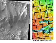
Map of Coprates quadrangle showing details of Valles Marineris, the largest canyon system in the solar system. Some of the canyons may have once been filled with water.
Melas Chasma, as seen by THEMIS. Click on image to see relationship of Melas Chasma to other features.

Cliff in Candor Chasma Plateau, as seen by THEMIS. Click on image to see relationship with other features in Coprates quadrangle.
Cliff in northern wall of Ganges Chasma, as seen by THEMIS. Click on image to see relationship with other features in the Coprates quadrangle.


Interior layered deposits and sulfate
This quadrangle, as indeed many other quadrangles of Mars, show much evidence of vast amounts of water in the past. Some features like old stream beds clearly point toward a water-rich past for Mars. However, layered features and their chemistry, although not as striking, provide great support for large amounts of water in the past. Parts of the floors of Candor Chasma and Juventae Chasma contain layered deposits that have been given the name interior layered deposits (ILD's) and Equatorial Layered Deposits (ELD's). These layers may have formed when the whole area was a giant lake. However, many other ideas have been advanced to explain them.[11] > High-resolution structural and geologic mapping in west Candor Chasma, presented in March 2015, showed that the deposits on the floor of the Candor Chasma are basin filling sediments that were deposited in a wet playa like setting; hence water was involved in their formation.[12] Some places on Mars contain hydrated sulfate deposits, including ILD's. Sulfate formation involves the presence of water. The European Space Agency's Mars Express found possible evidence of the sulfates epsomite and kieserite. Sulfates that contain water are found in many places on the planet. Usually, they show up in pictures as light-toned materials. These are in striking contrast to the widespread dark volcanic surfaces. Scientists want to visit these areas with robotic rovers.[13] These deposits have been found to contain ferric oxides in the form of crystalline grey hematite.[14] [15] [16] Grey hematite is another sign of water as it usually forms with the aid of water.
Layers
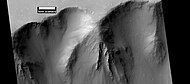
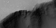
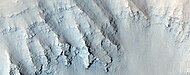
Perhaps, the best location to view layers on Mars is in the Coprates quadrangle. This is probably because of so many huge, deep canyons that display layer after layer in their walls. Images of rocks in the canyon walls almost always show layers.[17] Layered rocks have different characteristics. Some layers appear tougher than others. In the image below of Ganges Chasma Layers, as seen by HiRISE, one can see that the upper, light-toned deposits are eroding much faster than the lower darker layers. Some cliffs on Mars show a few darker layers standing out and often breaking into large pieces; these are thought to be hard volcanic rock instead of soft ash deposits. An example of hard layers is shown below in the picture of layers in the canyon wall in Coprates, as seen by Mars Global Surveyor. Because of its closeness to the Tharsis volcanic region, rock layers may be made of layer after layer of lava flows, probably mixed with deposits of volcanic ash that fell out of the air following big eruptions. Rock strata visible in the walls preserve a long geological history of Mars.[18] The Earth does not possess long records of geological history since plate tectonics erases rock materials at more or less regular intervals. Dark layers in canyon walls may be due to dark lava flows. The dark volcanic rock basalt dominates the Martian surface. However, light-toned deposits appear in many spots, and those deposits may have resulted from rivers, lakes, volcanic ash, or windblown deposits of sand or dust.[19] The Mars Rovers found light-toned rocks to contain sulfates. Probably having been formed in water, sulfate deposits are of great interest to scientists because they may contain traces of ancient life.[20]
Ganges Chasma Layers, as seen by HiRISE.

Layers in the canyon wall in Coprates, as seen by Mars Global Surveyor, under the MOC Public Targeting Program.

Wide view of layers in wall of Valles Marineris, as seen by HiRISE under HiWish program.
Close-up of layers in wall of Valles Marineris, as seen by HiRISE under HiWish program.

Part of wall of Valles Marineris, as seen by HiRISE under HiWish program.

Close-up of part of previous image of wall of Valles Marineris, as seen by HiRISE under HiWish program.
Layers in trough south of Ius Chasma, as seen by HiRISE under HiWish program
Close up of layers in trough south of Ius Chasma, as seen by HiRISE under HiWish program Note: this is enlargement of the previous image using HiView
Layers in Monument Valley. These are accepted as being formed, at least in part, by water deposition. Since Mars contains similar layers, water remains as a major cause of layering on Mars.
Layers west of Juventae Chasma, as seen by HiRISE. Scale bar is 500 meters long.

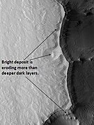
Orson Welles Crater, as seen by HiRISE. Layered, light-toned rocks seem to be under a dark mantling material. Layers may be sandstone, volcanic ash, or lakebed deposits.

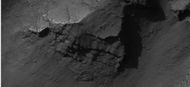
Corprates Chasma Fault, as seen by HiRISE. Layers in the rock face may be from volcanic, lacustrine, and/or aeolian sediments deposited in Valles Marineris.

Ritchey Crater layers, as seen by HiRISE. The dark cap layer seems to be resistant to erosion, while the white middle layer is weak. Click on image to see more details. Scale bar is 500 meters long.

Two views of Melas Chasma Layered Deposits, as seen by HiRISE. Left picture lies north of other picture on the right. Pictures are not the same scale. Click on image to see details of layers.

Tithonium Chasma Layers, as seen by HiRISE.

Layers and dark dunes on the floor of a crater, as seen by HiRISE under the HiWish program. Groundwater may have risen up in the crater and cemented sediments with minerals.

Wide view of layers south of Ius Chasma, as seen by HiRISE under HiWish program

Close view of layers south of Ius Chasma, as seen by HiRISE under HiWish program Note: this is an enlargement of the previous wide view.

Close view of layers south of Ius Chasma, as seen by HiRISE under HiWish program Note: this is an enlargement of a previous wide view.


Layers near top of crater wall, as seen by HiRISE under HiWish program

Close view of layers near top of crater wall, as seen by HiRISE under HiWish program


Wide view of layers in Louros Valles, as seen by HiRISE under HiWish program Louros Valles is part of the Ius Chasma.

Close view of layers in Louros Valles, as seen by HiRISE under HiWish program Note this is an enlargement of a previous image.

Close view of layers in Louros Valles, as seen by HiRISE under HiWish program Note this is an enlargement of a previous image.

Close view of layers in Louros Valles, as seen by HiRISE under HiWish program Note this is an enlargement of a previous image.
Close view of layers in Louros Valles, as seen by HiRISE under HiWish program Note this is an enlargement of a previous image.


Hebes Chasma and hydrated deposits
Hebes Chasma, a large enclosed valley, may have once held water. Hydrated minerals have been found there. It is thought that large-scale underground springs of groundwater at different times burst to the surface to form deposits called Light Toned Deposits (LTD's). Some suggest present or fossilized life forms may be found there because the deposits are relatively young.[21]
Nirgal Vallis and sapping
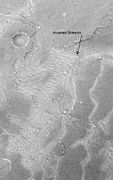
Nirgal Vallis is one of the longest valley networks on Mars. It is so large that it is found on more than one quadrangle. Scientists do not know how all the ancient river valleys were formed. There is evidence that instead of rain or snow, the water that formed the valleys originated underground. One mechanism that has been advanced is groundwater sapping.[22] In the process of sapping, the ground just gives away as water comes out. Sapping is common in some desert areas in America's Southwest. Sapping forms alcoves and stubby tributaries. These features are visible in the picture below of Nigal Vallis taken with Mars Odyssey's THEMIS.
Great flood in Holden Crater
Water from Nirgal Vallis contributed to a great flood that went through the rim of Holden Crater and helped form a lake in the crater. It's estimated that Nirgal Vallis had a discharge of 4800 cubic meters/second.[23] Water from Nirgal Vallis was inbounded in Uzboi Vallis because the rim of Holden Crater blocked the flow. At a certain point the stored water broke through the rim of Holden and created a lake 200–250 m deep.[24] Water with a depth of at least 50 m entered Holden at a rate that 5-10 times the discharge of the Mississippi River.[25] [26] [27] [28] Terraces and the presence of large rocks (tens of meters across) support these high discharge rates.Cite error: Closing </ref> missing for <ref> tag [29] [30] [31]

Nirgal Vallis that runs in two quadrangles has features looking like those caused by sapping. Picture taken with THEMIS.

Inverted relief
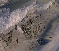
Some areas of Mars show inverted relief, where features that were once depressions, like streams, are now instead above the surface. These may have been formed when materials, like large rocks, were deposited in low-lying areas, and then left behind after erosion (perhaps wind which cannot move large rocks) removed much of the surface layers. Other ways of making inverted relief might be lava flowing down a stream bed or cementation of rock material by minerals dissolved in water. Some cementing materials are very hard and resistant to erosion. On Earth, materials cemented by silica are highly resistant to all kinds of erosional forces. Inverted relief in the shape of streams is further evidence of water flowing on the Martian surface in past times. There are many examples of inverted channels near Juventae Chasma; some are shown in the image of Juventae Chasma below.[32] [33] [34]

Inverted Channels near Juventae Chasma, as seen by HiRISE. Channels were once regular stream channels. Scale bar is 500 meters long.
Inverted Streams near Juventae Chasma, as seen by Mars Global Surveyor. These streams begin at the top of a ridge then run together.


Vallis
Vallis (plural valles) is the Latin word for valley. It is used in planetary geology for the naming of landform features on other planets. The term “Vallis” was used for old river valleys that were discovered on Mars, when probes were first sent to Mars. The Viking Orbiters caused a revolution in our ideas about water on Mars; huge river valleys were found in many areas. Spacecraft cameras showed that floods of water broke through dams, carved deep valleys, eroded grooves into bedrock, and traveled thousands of kilometers.[35] [36] [37]

Her Desher Vallis, as seen by HiRISE.

Her Desher Vallis close-up, as seen by HiRISE.


Recurrent slope lineae
Recurrent slope lineae (RSL) are small dark streaks on slopes that elongate in warm seasons. They may be evidence of liquid water.[38][39][40]

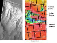
Wide view of part of Valles Marineris, as seen by HiRISE under HiWish program Box shows location of recurrent slope lineae that are enlarged in next image.
Close, color view of recurrent slope lineae, as seen by HiRISE under HiWish program Arrows point to some of the recurrent slope lineae

Recurrent slope lineae elongate when the slopes are at their warmest. Near the equator, RSL elongate on northern slopes in the northern summer and on the southern slopes in the southern summer.


- ↑ Davies, M.E.; Batson, R.M.; Wu, S.S.C. "Geodesy and Cartography" in Kieffer, H.H.; Jakosky, B.M.; Snyder, C.W.; Matthews, M.S., Eds. Mars. University of Arizona Press: Tucson, 1992.
- ↑ Cabrol, N. and E. Grin (eds.). 2010. Lakes on Mars. Elsevier. NY
- ↑ Blunck, J. 1982. Mars and its Satellites. Exposition Press. Smithtown, N.Y.
- ↑ "Coprates quadrangle". Gazetteer of Planetary Nomenclature. USGS Astrogeology Research Program.
- ↑ Smith, William, ed. (1854). "Dictionary of Greek and Roman Geography". Perseus Digital Library. Tufts University. Retrieved 6 Dec 2016.
- ↑ Cabrol, N. and E. Grin (eds.). 2010. Lakes on Mars. Elsevier. NY
- ↑ McCauley, J. 1978. Geologic map of the Coprates quadrangle of Mars. U.S. Geol. Misc. Inv. Map I-897
- ↑ {{cite journal | last1 = Nedell | first1 = S. | display-authors = etal | year = 1987 | title = Origin and evolution of the layered deposits in the Valles Marineris, Mars | url = | journal = Icarus | volume = 70 | issue = 3| pages = 409–441 | doi=10.1016/0019-1035(87)90086-8 |
- ↑ Weitz, C. and T. Parker. 2000. New evidence that the Valles Marineris interior deposits formed in standing bodies of water. LPSC XXXI. Abstract 1693
- ↑ Hugh H. Kieffer|title=Mars|url=https://books.google.com/books?id=NoDvAAAAMAAJ%7Caccessdate=7 March 2011|year=1992|publisher=University of Arizona Press|
- ↑ Cabrol, N. and E. Grin (eds.). 2010. Lakes on Mars. Elsevier. NY
- ↑ Okubo, C. 2015. HIGH-RESOLUTION STRUCTURAL AND GEOLOGIC MAPPING IN CANDOR CHASMA. 46th Lunar and Planetary Science Conference. 1210.pdf
- ↑ http://themis.asu.edu/features/candorchasma |title=Bath Salts in Candor Chasma? | Mars Odyssey Mission THEMIS |publisher=Themis.asu.edu |
- ↑ Cabrol, N. and E. Grin (eds.). 2010. Lakes on Mars. Elsevier. NY
- ↑ Christensen | first1 = P. | display-authors = etal | year = 2001 | title = Global mapping of Martian hematite mineral deposits: Remnants of water-driven processes on early Mars | url = | journal = J. Geophys. Res. | volume = 106 | issue = E10| pages = 23873–23885 | doi=10.1029/2000je001415 |
- ↑ Weitz | first1 = C. | display-authors = etal | year = 2008 | title = Gray hematite distribution and formation in Ophir and Candor Chasmata | url = | journal = J. Geophys. Res. | volume = 113 | issue = E2| page = E02016 | doi=10.1029/2007je002930 |
- ↑ Grotzinger, J. and R. Milliken. 2012. Sedimentary Geology of Mars. SEPM.
- ↑ http://themis.asu.edu/features/coprateschasma |title=Landslides and Debris in Coprates Chasma | Mars Odyssey Mission THEMIS |publisher=Themis.asu.edu |date= |
- ↑ http://hirise.lpl.arizona.edu/PSP_005385_1640 |title=HiRISE | Light-toned Layers in Eos Chaos (PSP_005385_1640) |publisher=Hirise.lpl.arizona.edu |date= |
- ↑ http://hirise,lpl.arizona.edu/PSP_007430_1725
- ↑ May Have Played Important Role in Shaping Mars
- ↑ http://themis.asu.edu/zoom-20030916a
- ↑ Irwin | first1 = J. | last2 = Craddock | first2 = R. | last3 = Howard | first3 = R. | year = 2005 | title = Interior channels in Martian valley networks: Discharge and runoff production | url = | journal = Geology | volume = 33 | issue = 6| pages = 489–492 | doi=10.1130/g21333.1|
- ↑ Grant, J., R. Irwin, S. Wilson. 2010. Aqueous depositional settings in Holden crater, Mars In Cabrol, N. and E. Grin (eds.). 2010. Lakes on Mars. Elsevier. NY.
- ↑ Grant | first1 = J. | last2 = Parker | first2 = T. | year = 2002 | title = Drainage evolution of the Margaritifer Sinus region, Mars | url = | journal = J. Geophys. Res. | volume = 107 | issue = E9| pages = 5066 | doi = 10.1029/2001JE001678 |
- ↑ Komar | first1 = P | year = 1979 | title = Comparisons of the hydraulics of water flows in Martian outflow channels with flows of similar scale on Earth | url = | journal = Icarus | volume = 37 | issue = 1| pages = 156–181 | doi=10.1016/0019-1035(79)90123-4 |
- ↑ Grant | first1 = J. |display-authors=et al | year = 2008 | title = HiRISE imaging of impact megabreccia and sub-meter aqueous strata in Holden Crater, Mars | url = | journal = Geology | volume = 36 | issue = 3| pages = 195–198 | doi=10.1130/g24340a.1|
- ↑ Irwin |display-authors=et al | year = 2005 | title = An intense terminal epoch of widespread fluvial activity on early Mars: 2. Increased runoff and paleolake development | url = | journal = J. Geophys. Res. | volume = 110 | issue = E12| pages = E12S15| doi = 10.1029/2005JE002460 |
- ↑ Boothroyd, J. 1983. Fluvial drainage systems in the Ladon Basin area: Margaritifer Sinus area, Mars. Geol. Soc. Am. Abstr. Programs 15, 530
- ↑ Grant, J. 1987. The geomorphic evolution of Eastern Margaritifer Sinus, Mars. Adv. Planet. Geol. NASA Tech memo. 89871, 1-268.
- ↑ Parker, T. 1985. Geomorphology and geology of the southwestern Margaritifer Sinus-northern Argyre region of Mars, California State University, M. S. Thesis, Los Angeles, California
- ↑ http://hirise.lpl.arizona.edu/PSP_006770_1760 |title=HiRISE | Inverted Channels North of Juventae Chasma (PSP_006770_1760) |publisher=Hirise.lpl.arizona.edu |
- ↑ Malin, M., et al. 2010. An overview of the 1985-2006 Mars Orbiter Camera science investigation. http://marsjournal.org
- ↑ http://www.sciencedirect.com/science/journal/00191035 |title=Icarus | Vol 221, Iss 1, In Progress , (September–October, 2012) |date= |
- ↑ Hugh H. Kieffer (1992). Mars. University of Arizona Press. ISBN 978-0-8165-1257-7.
- ↑ Raeburn, P. 1998. Uncovering the Secrets of the Red Planet Mars. National Geographic Society. Washington D.C.
- ↑ Moore, P. et al. 1990. The Atlas of the Solar System. Mitchell Beazley Publishers NY, NY.
- ↑ McEwen, A., et al. 2014. Recurring slope lineae in equatorial regions of Mars. Nature Geoscience 7, 53-58. doi:10.1038/ngeo2014
- ↑ McEwen, A., et al. 2011. Seasonal Flows on Warm Martian Slopes. Science. 05 Aug 2011. 333, 6043,740-743. DOI: 10.1126/science.1204816
- ↑ http://redplanet.asu.edu/?tag=recurring-slope-lineae


