File:CCSDS DDOR Observation Geometry.png
Revision as of 22:51, 19 December 2018 by Pb (talk | contribs) (Figure representing the geometry when performing Delta-DOR measurements for spacecraft navigation. Obtained from the CCSDS May 2013 Green Book, Delta-DOR Technical Characteristics and Performance. Available here: https://public.ccsds.org/Pubs/500x1g1.pdf)
No higher resolution available.
CCSDS_DDOR_Observation_Geometry.png (451 × 452 pixels, file size: 50 KB, MIME type: image/png)
Summary
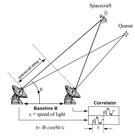
Figure representing the geometry when performing Delta-DOR measurements for spacecraft navigation.
Obtained from the CCSDS May 2013 Green Book, Delta-DOR Technical Characteristics and Performance. Available here: https://public.ccsds.org/Pubs/500x1g1.pdf
File history
Click on a date/time to view the file as it appeared at that time.
| Date/Time | Thumbnail | Dimensions | User | Comment | |
|---|---|---|---|---|---|
| current | 22:51, 19 December 2018 | | 451 × 452 (50 KB) | Pb (talk | contribs) | Figure representing the geometry when performing Delta-DOR measurements for spacecraft navigation. Obtained from the CCSDS May 2013 Green Book, Delta-DOR Technical Characteristics and Performance. Available here: https://public.ccsds.org/Pubs/500x1g1.pdf |
You cannot overwrite this file.
File usage
The following page uses this file:


