File:CuriosityjpegPIA23974.width-1440.jpg
Original file (1,440 × 669 pixels, file size: 284 KB, MIME type: image/jpeg)
Summary
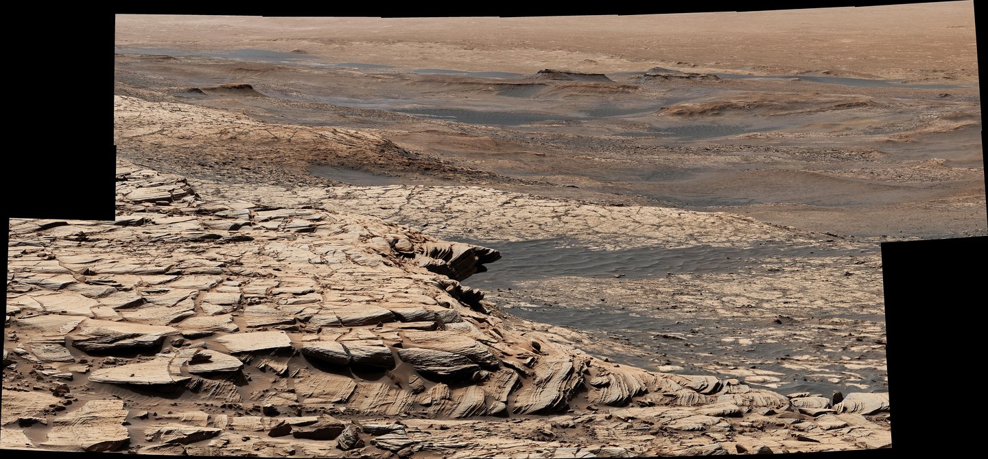
Stitched together from 28 images, this view from NASA's Curiosity Mars rover was captured on April 9, 2020, the 2,729th Martian day, or sol, of the mission after the rover ascended a steep slope, part of a geologic feature called "Greenheugh Pediment." In the foreground is the crusty sandstone cap that stretches the length of the pediment, forming an overhanging ledge in some parts. At center is the "clay-bearing unit," a region with a unique story to tell about the history of water on Mount Sharp, the 3-mile-tall (5-kilometer-tall) mountain Curiosity has been ascending since 2014. In the distance at the top of the image is the floor of Gale Crater, which is 96 miles (154 kilometers) wide.
The rover's Mast Camera, or Mastcam, provided the panorama. Malin Space Science Systems in San Diego built and operates Mastcam. A division of Caltech, NASA's Jet Propulsion Laboratory in Southern California built the Curiosity rover and manages the Mars Science Laboratory mission for the agency's Science Mission Directorate in Washington.
The panorama has been white-balanced so that the colors of the rock materials resemble how they would appear under daytime lighting conditions on Earth.
This is the general location where higher levels of possibly biologically produced carbon 12 was discovered..
Source: https://www.jpl.nasa.gov/images/pia23974-curiositys-view-from-the-top-of-the-greenheugh-pediment
Image credit: NASA/JPL-Caltech/MSSS
Licensing
Public domain images are available for anybody to use without any licenses, royalties, or special permissions.
File history
Click on a date/time to view the file as it appeared at that time.
| Date/Time | Thumbnail | Dimensions | User | Comment | |
|---|---|---|---|---|---|
| current | 16:56, 20 January 2022 | | 1,440 × 669 (284 KB) | Suitupandshowup (talk | contribs) | Stitched together from 28 images, this view from NASA's Curiosity Mars rover was captured on April 9, 2020, the 2,729th Martian day, or sol, of the mission after the rover ascended a steep slope, part of a geologic feature called "Greenheugh Pediment." In the foreground is the crusty sandstone cap that stretches the length of the pediment, forming an overhanging ledge in some parts. At center is the "clay-bearing unit," a region with a unique story to tell about the history of water on Mount... |
You cannot overwrite this file.
File usage
The following page uses this file:


