File:Hellas basin.jpg
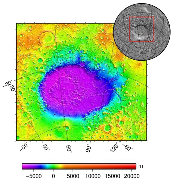
Revision as of 14:55, 7 December 2007 by Ioneill (talk | contribs) (===Description=== Hellas basin (Mars) topography using the Mars Orbiter Laser Altimeter (MOLA) instrument on the Mars Global Surveyor orbiter. :Image credit: Martin Pauer (http://commons.wikimedia.org/wiki/User:Power) :Source: http://en.wikipedia.or)
No higher resolution available.
Hellas_basin.jpg (575 × 600 pixels, file size: 77 KB, MIME type: image/jpeg)
Description
Hellas basin (Mars) topography using the Mars Orbiter Laser Altimeter (MOLA) instrument on the Mars Global Surveyor orbiter.
- Image credit: Martin Pauer (http://commons.wikimedia.org/wiki/User:Power)
File history
Click on a date/time to view the file as it appeared at that time.
| Date/Time | Thumbnail | Dimensions | User | Comment | |
|---|---|---|---|---|---|
| current | 14:55, 7 December 2007 | | 575 × 600 (77 KB) | Ioneill (talk | contribs) | ===Description=== Hellas basin (Mars) topography using the Mars Orbiter Laser Altimeter (MOLA) instrument on the Mars Global Surveyor orbiter. :Image credit: Martin Pauer (http://commons.wikimedia.org/wiki/User:Power) :Source: http://en.wikipedia.or |
You cannot overwrite this file.
File usage
The following 2 pages use this file:


