Difference between revisions of "Syrtis Major quadrangle"
(added pictures, info, and ref) |
|||
| Line 12: | Line 12: | ||
File:Syrtis Major MC-13 - PIA00173.tiff | File:Syrtis Major MC-13 - PIA00173.tiff | ||
</gallery> | </gallery> | ||
| + | |||
| + | The Syrtis Major quadrangle covers latitudes 0° to 30° N and longitudes 270° to 315° W (45-90E). Syrtis Major quadrangle includes some other named regions: Syrtis Major Planum, and parts of Terra Sabaea and Isidis Planitia.<ref>Davies, M.E.; Batson, R.M.; Wu, S.S.C. "Geodesy and Cartography" in Kieffer, H.H.; Jakosky, B.M.; Snyder, C.W.; Matthews, M.S., Eds. ''Mars.'' University of Arizona Press: Tucson, 1992.</ref> | ||
| + | Geologically, Syrtis Major is an ancient shield volcano with a central depression that is elongated in a north-south direction. Calderas are large openings at the top of volcanoes. Syrtis Major contains the calderas named Meroe Patera and Nili Patera.<ref>http://www.daviddarling.info/encyclopedia/S/SyrtisMajor.html</ref> Other geologically interesting features in the area include dikes and inverted terrain. | ||
| + | The ''[[Beagle 2]]'' lander crashed in this quadrangle in December 2003. In January 2015, NASA reported the ''Beagle 2'' that had found it in [[Isidis Planitia]] (location is about 11.5265 N and 90.4295E.<ref> Ellison, Doug (16 January 2015). "re Beagle 2 location on Mars => "Using HiView on image ESP_039308_1915_COLOR.JP2 I get 90.4295E 11.5265N"". Twitter & JPL.</ref> <ref> Grecicius, Tony; Dunbar, Brian (16 January 2015). "Components of Beagle 2 Flight System on Mars". NASA. https://twitter.com/doug_ellison/status/556201983443357696 |</ref> <ref>="NASA-20150116-TG" Grecicius |first1=Tony |last2=Dunbar |first2=Brian |title=Components of Beagle 2 Flight System on Mars |url=http://www.nasa.gov/jpl/mars/pia19106/ |date=16 January 2015 </ref> It was imaged by HiRISE onboard the [[Mars Reconnaissance Orbiter]]. Beagle 2 looked intact.<ref> name="NASA-20150116" Webster |first=Guy |title='Lost' 2003 Mars Lander Found by Mars Reconnaissance Orbiter |url=http://www.nasa.gov/jpl/lost-2003-mars-lander-found-by-mars-reconnaissance-orbiter/ |date=16 January 2015 |work=[[NASA]] |</ref> <ref>https://www.nytimes.com/2015/01/17/science/space/missing-lander-beagle-2-finally-located-on-mars.html |date=16 January 2015 |work=New York Times</ref> <ref>Amos |first=Jonathan |title=Lost Beagle2 probe found 'intact' on Mars |url=https://www.bbc.co.uk/news/science-environment-30784886 |date=16 January 2015 </ref> | ||
| + | In November 2018, NASA announced that [[Jezero crater]] was chosen as the landing site for the planned Mars 2020 mission.<ref>"SPC-20181119">Wall |first=Mike |title=Jezero Crater or Bust! NASA Picks Landing Site for Mars 2020 Rover |url=https://www.space.com/42486-mars-2020-rover-jezero-crater-landing-site.html |date=19 November 2018 |work=Space.com |</ref> [[Jezero Crater]] is located at 18.855N and 77.519 E<ref> Wray, James (6 June 2008). "Channel into Jezero Crater Delta". NASA. < /ref> | ||
| + | The rest of this article will cover significant scientific discoveries and show what the landscape looks like close up. We will be learning and hearing much more about this area when Mars 2020 lands in Jezero Crater. | ||
| + | ==How named== | ||
| + | Syrtis Major is named after the classical Roman name ''Syrtis maior'' for the Gulf of Sidra that is found on the coast of Libya (classical Cyrenaica). Interestingly, Syrtis Major is near Cyrene which accoding to the Bilbe is the place where "Simon" who carried the cross of Jesus was from.<ref>https://ferrelljenkins.wordpress.com/2011/03/30/libya-and-the-bible-%E2%80%94-more-than-you-think/</ref> <ref>https://books.google.com/books?id=3JNQAQAAMAAJ&pg=PA18 ''The Cambridge Bible for Schools and Colleges'', Volume 59</ref> <ref>Gleig, G. and T. Stackhouse. ''A History of the holy Bible, corrected and improved''. https://books.google.com/books?id=jVIOAAAAQAAJ&pg=PA286</ref> | ||
| + | ==Discovery and history== | ||
| + | Syrtis Major is the main marking that people see when they look at Mars through a backyard telescope. It was discovered by Christiaan Huygens, who included it in a drawing of Mars in 1659 and was originally known as the '''Hourglass Sea.” Different cartographers have given it different names over centuries. Johann Heinrich von Mädler in 1840 called the feature “Atlantic Canale.” Richard Proctor called it “Kaiser Sea” in 1867 . A little later, Camille Flammarion called it the “Mer du Sablier” (French for "Hourglass Sea") when he updated Proctor's naming system in 1876. Syrtis Major, the name that has stock was picked by Giovanni Schiaparelli when he created a map based on observations made during Mars' close approach to Earth in 1877.<ref>Mapping Mars: Science, Imagination, and the Birth of a World| first=Oliver| last=Morton| publisher=Picador USA| location=New York| date=2002| isbn=0-312-24551-3| pages=[https://archive.org/details/mappingmarsscien00mort_0/page/14 14]–15|</ref> <ref>http://www.uapress.arizona.edu/onlinebks/mars/chap04.htm|title=The Planet Mars: A History of Observation and Discovery - Chapter 4: Areographers|author=William Sheehan|</ref> | ||
| + | |||
| + | == Igneous rocks == | ||
| + | The Syrtis Major region is of great interest to geologists since several types of igneous rocks have been found there with orbiting spacecraft. Besides basalt, dacite and granite have been found there with orbiting satellites. Dacite originates under volcanoes in magma chambers. In magma chambers new minerals and rocks are put together. After heavy minerals (olivine and pyroxene) containing iron and magnesium have settled to the bottom, Dacites form at the top of the chamber. Granite is formed by an even more complex process.<ref>Christensen, P. 2005. "The Many Faces of Mars". ''Scientific American''. July, 2005.</ref> Some areas of Syrtis Major contain large amounts of the mineral olivine. Olivine turns into other minerals very rapidly in the presence of water, so if we find olivine, we know that the place has been dry for a long time.<ref>http://www.marsdaily.com/news-odyssey-05a.html</ref> | ||
| + | ==Minerals== | ||
| + | A variety of important minerals have been discovered near [[Nili Fossae]], a major trough system in Syrtis Major. Besides olivine, other minerals found there include carbonates, aluminum smectite, iron/magnesium smectite, hydrated silica, kaolinite group minerals, and iron oxides.<ref>http://news.bbc.co.uk/2/hi/science/nature/7791060.stm "Nasa finds 'missing' Mars mineral"</ref> <ref>Murchie, S. et al. 2009. "A synthesis of Martian aqueous mineralogy after 1 Mars year of observations from the Mars Reconnaissance Orbiter". ''Journal of Geophysical Research'': 114. E00D06.</ref> In December 2008, NASA's Mars Reconnaissance Orbiter found carbonate minerals, a geologically significant discovery.<ref>http://news.bbc.co.uk/2/hi/science/nature/7791060.stm NASA finds 'missing' Mars mineral</ref> <ref>http://www.space.com/30746-mars-missing-atmosphere-lost-in-space.html</ref><ref>Edwards, C., B. Ehlmann. 2015. "Carbon sequestration on Mars". ''Geology'': doi: 10.1130/G36983.1.</ref> Later research published in October 2010, described a large deposit of carbonate rocks found inside Leighton Crater. The rocks at one time were buried 4 miles below the surface. This discovery has great importance in understanding the history of the planet. Finding carbonates in an underground location means that Mars may have been warmer and may have had atmospheric carbon dioxide and ancient seas. Because the carbonates were found near silicate minerals and clays, hydrothermal systems like the deep sea vents on Earth may have been present.<ref>http://www.astrobio.net/pressrelease/3646/exposed-rocks-point-to water-on-ancient-mars</ref> <ref>1.Adrian J. Brown, Simon J. Hook, Alice M. Baldridge, James K. Crowley, Nathan T. Bridges, Bradley J. Thomson, Giles M. Marion, Carlos R. de Souza Filho, Janice L. Bishop. "Hydrothermal formation of Clay-Carbonate alteration assemblages in the Nili Fossae region of Mars". ''Earth and Planetary Science Letters'', 2010; </ref> | ||
| + | Other minerals found by the Mars Reconnaissance Orbiter are aluminum smectite, iron/magnesium smectite, hydrated silica, kaolinite group minerals, iron oxides, and talc.<ref> Murchie, S. et al. 2009. "A synthesis of Martian aqueous mineralogy after 1 Mars year of observations from the Mars Reconnaissance Orbiter". Journal of Geophysical Research: 114. E00D06.</ref> <ref> Adrian J. Brown, Simon J. Hook, Alice M. Baldridge, James K. Crowley, Nathan T. Bridges, Bradley J. Thomson, Giles M. Marion, Carlos R. de Souza Filho, Janice L. Bishop. "Hydrothermal formation of Clay-Carbonate alteration assemblages in the Nili Fossae region of Mars". ''Earth and Planetary Science Letters'', 2010; </ref> | ||
| + | NASA scientists have also discovered that Nili Fossae is the source of plumes of methane, raising the question of whether this source originates from biological sources.<ref>http://dsc.discovery.com/news/2009/01/15/mars-methane-life.html Mars Methane Found, Raising Possibility of Life</ref> <ref>http://news.bbc.co.uk/2/hi/science/nature/7829315.stm New light on Mars methane mystery</ref> | ||
| + | == Dikes == | ||
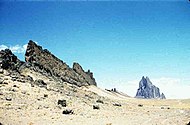
| + | Narrow ridges occur in some places on Mars. They may be formed by different means, but some are probably caused by molten rock moving underground and moving along cracks or faults in the rock. When they cool, walls of hard rock may be formed after being exposed by the erosion of softer, surrounding materials. Such a feature is termed a dike. They are common on Earth—a famous one is Shiprock, New Mexico;<ref>http://www.msss.com/mars_images/moc/2005/10/13/</re> <ref>isbn = 0-87842-105-X|title = Roadside Geology of Colorado|last1 = Chronic|first1 = Halka|date = January 1980</ref> | ||
| + | <gallery class="center" widths="190px" heights="180px" > | ||
| + | Image:Dikes-large.jpg|Dikes near Shiprock, New Mexico | ||
| + | Image:WestSpanishPeakCO.jpg|WestSpanishPeak, CO | ||
| + | </gallery> | ||
| + | Mapping the presence of dikes allows us to understand how magma (molten rock under the ground) travels and where it could have interacted with surrounding rock, thus producing valuable ores. Deposits of important minerals are also made by dikes and other types of magma movements. These superhot liquid rocks heat water. The hot water dissolves minerals that are deposited in cracks in nearby rock. This process has given us many sources of important minerals.<ref>Namowitz, S. and D. Stone. 1975. ''Earth Science-The World We Live In''. American Book Company. Ny, NY</ref> One would expect a great deal of intrusive igneous activity (molten rock under the ground) to occur on Mars because it is believed there is more igneous activity under the ground than on top, and Mars has many huge volcanoes. In other words, more liquid rock was under the surface than in the many massive Martian volcanoes.<ref>Crisp, J. 1984. "Rates of magma emplacement and volcanic output". ''J. Volcanlo. Geotherm. Res'': 20. 177-211.</ref> | ||
| + | <gallery class="center" widths="190px" heights="180px" > | ||
| + | ESP 046403 2095dike.jpg|Possible dike, as seen by [[HiRISE]] under [[HiWish program]] | ||
| + | Image:Dike from HiWish program.JPG|Box outlines area in next image from HiRISE. Knobs and mesas were probably formed from the erosion of deposits in an old crater. | ||
| + | Image:Dike in Syrtis Major.JPG|Possible dike from HiRISE under the HiWish program | ||
| + | </gallery> | ||
| + | ==Linear Ridge Networks== | ||
| + | Some crater floors in the Syrtis Major area show elongated ridges arranged in a complex pattern. Scientists are still debated over the exact origin of these features. Some have suggested that they are dikes made up of molten rock; others have advanced the idea that other fluids such as water were involved.<ref>Saper, L., J. Mustard. 2013. "Extensive linear ridge networks in Nili Fossae and Nilosyrtis, Mars: implications for fluid flow in the ancient crust". ''Geophysical Research Letters'': 40, 245-249.</ref> The ridges are found where there has been erosion. | ||
| + | |||
| + | |||
| + | |||
| + | |||
| + | |||
| + | |||
| + | |||
[[Category: Mars Atlas]] | [[Category: Mars Atlas]] | ||
Revision as of 10:12, 29 February 2020
| MC-13 | Syrtis Major | 0–30° N | 45–90° E | Quadrangles | Atlas |


The Syrtis Major quadrangle covers latitudes 0° to 30° N and longitudes 270° to 315° W (45-90E). Syrtis Major quadrangle includes some other named regions: Syrtis Major Planum, and parts of Terra Sabaea and Isidis Planitia.[1]
Geologically, Syrtis Major is an ancient shield volcano with a central depression that is elongated in a north-south direction. Calderas are large openings at the top of volcanoes. Syrtis Major contains the calderas named Meroe Patera and Nili Patera.[2] Other geologically interesting features in the area include dikes and inverted terrain.
The Beagle 2 lander crashed in this quadrangle in December 2003. In January 2015, NASA reported the Beagle 2 that had found it in Isidis Planitia (location is about 11.5265 N and 90.4295E.[3] [4] [5] It was imaged by HiRISE onboard the Mars Reconnaissance Orbiter. Beagle 2 looked intact.[6] [7] [8]
In November 2018, NASA announced that Jezero crater was chosen as the landing site for the planned Mars 2020 mission.[9] Jezero Crater is located at 18.855N and 77.519 ECite error: Closing </ref> missing for <ref> tag [10] [11]
Discovery and history
Syrtis Major is the main marking that people see when they look at Mars through a backyard telescope. It was discovered by Christiaan Huygens, who included it in a drawing of Mars in 1659 and was originally known as the Hourglass Sea.” Different cartographers have given it different names over centuries. Johann Heinrich von Mädler in 1840 called the feature “Atlantic Canale.” Richard Proctor called it “Kaiser Sea” in 1867 . A little later, Camille Flammarion called it the “Mer du Sablier” (French for "Hourglass Sea") when he updated Proctor's naming system in 1876. Syrtis Major, the name that has stock was picked by Giovanni Schiaparelli when he created a map based on observations made during Mars' close approach to Earth in 1877.[12] [13]
Igneous rocks
The Syrtis Major region is of great interest to geologists since several types of igneous rocks have been found there with orbiting spacecraft. Besides basalt, dacite and granite have been found there with orbiting satellites. Dacite originates under volcanoes in magma chambers. In magma chambers new minerals and rocks are put together. After heavy minerals (olivine and pyroxene) containing iron and magnesium have settled to the bottom, Dacites form at the top of the chamber. Granite is formed by an even more complex process.[14] Some areas of Syrtis Major contain large amounts of the mineral olivine. Olivine turns into other minerals very rapidly in the presence of water, so if we find olivine, we know that the place has been dry for a long time.[15]
Minerals
A variety of important minerals have been discovered near Nili Fossae, a major trough system in Syrtis Major. Besides olivine, other minerals found there include carbonates, aluminum smectite, iron/magnesium smectite, hydrated silica, kaolinite group minerals, and iron oxides.[16] [17] In December 2008, NASA's Mars Reconnaissance Orbiter found carbonate minerals, a geologically significant discovery.[18] [19][20] Later research published in October 2010, described a large deposit of carbonate rocks found inside Leighton Crater. The rocks at one time were buried 4 miles below the surface. This discovery has great importance in understanding the history of the planet. Finding carbonates in an underground location means that Mars may have been warmer and may have had atmospheric carbon dioxide and ancient seas. Because the carbonates were found near silicate minerals and clays, hydrothermal systems like the deep sea vents on Earth may have been present.[21] [22] Other minerals found by the Mars Reconnaissance Orbiter are aluminum smectite, iron/magnesium smectite, hydrated silica, kaolinite group minerals, iron oxides, and talc.[23] [24] NASA scientists have also discovered that Nili Fossae is the source of plumes of methane, raising the question of whether this source originates from biological sources.[25] [26]
Dikes
Narrow ridges occur in some places on Mars. They may be formed by different means, but some are probably caused by molten rock moving underground and moving along cracks or faults in the rock. When they cool, walls of hard rock may be formed after being exposed by the erosion of softer, surrounding materials. Such a feature is termed a dike. They are common on Earth—a famous one is Shiprock, New Mexico;Cite error: Closing </ref> missing for <ref> tag
Dikes near Shiprock, New Mexico

WestSpanishPeak, CO


Mapping the presence of dikes allows us to understand how magma (molten rock under the ground) travels and where it could have interacted with surrounding rock, thus producing valuable ores. Deposits of important minerals are also made by dikes and other types of magma movements. These superhot liquid rocks heat water. The hot water dissolves minerals that are deposited in cracks in nearby rock. This process has given us many sources of important minerals.[27] One would expect a great deal of intrusive igneous activity (molten rock under the ground) to occur on Mars because it is believed there is more igneous activity under the ground than on top, and Mars has many huge volcanoes. In other words, more liquid rock was under the surface than in the many massive Martian volcanoes.[28]
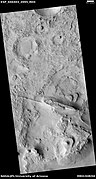
Possible dike, as seen by HiRISE under HiWish program

Box outlines area in next image from HiRISE. Knobs and mesas were probably formed from the erosion of deposits in an old crater.

Possible dike from HiRISE under the HiWish program


Linear Ridge Networks
Some crater floors in the Syrtis Major area show elongated ridges arranged in a complex pattern. Scientists are still debated over the exact origin of these features. Some have suggested that they are dikes made up of molten rock; others have advanced the idea that other fluids such as water were involved.[29] The ridges are found where there has been erosion.
- ↑ Davies, M.E.; Batson, R.M.; Wu, S.S.C. "Geodesy and Cartography" in Kieffer, H.H.; Jakosky, B.M.; Snyder, C.W.; Matthews, M.S., Eds. Mars. University of Arizona Press: Tucson, 1992.
- ↑ http://www.daviddarling.info/encyclopedia/S/SyrtisMajor.html
- ↑ Ellison, Doug (16 January 2015). "re Beagle 2 location on Mars => "Using HiView on image ESP_039308_1915_COLOR.JP2 I get 90.4295E 11.5265N"". Twitter & JPL.
- ↑ Grecicius, Tony; Dunbar, Brian (16 January 2015). "Components of Beagle 2 Flight System on Mars". NASA. https://twitter.com/doug_ellison/status/556201983443357696 |
- ↑ ="NASA-20150116-TG" Grecicius |first1=Tony |last2=Dunbar |first2=Brian |title=Components of Beagle 2 Flight System on Mars |url=http://www.nasa.gov/jpl/mars/pia19106/ |date=16 January 2015
- ↑ name="NASA-20150116" Webster |first=Guy |title='Lost' 2003 Mars Lander Found by Mars Reconnaissance Orbiter |url=http://www.nasa.gov/jpl/lost-2003-mars-lander-found-by-mars-reconnaissance-orbiter/ |date=16 January 2015 |work=NASA |
- ↑ https://www.nytimes.com/2015/01/17/science/space/missing-lander-beagle-2-finally-located-on-mars.html |date=16 January 2015 |work=New York Times
- ↑ Amos |first=Jonathan |title=Lost Beagle2 probe found 'intact' on Mars |url=https://www.bbc.co.uk/news/science-environment-30784886 |date=16 January 2015
- ↑ "SPC-20181119">Wall |first=Mike |title=Jezero Crater or Bust! NASA Picks Landing Site for Mars 2020 Rover |url=https://www.space.com/42486-mars-2020-rover-jezero-crater-landing-site.html |date=19 November 2018 |work=Space.com |
- ↑ https://books.google.com/books?id=3JNQAQAAMAAJ&pg=PA18 The Cambridge Bible for Schools and Colleges, Volume 59
- ↑ Gleig, G. and T. Stackhouse. A History of the holy Bible, corrected and improved. https://books.google.com/books?id=jVIOAAAAQAAJ&pg=PA286
- ↑ Mapping Mars: Science, Imagination, and the Birth of a World| first=Oliver| last=Morton| publisher=Picador USA| location=New York| date=2002| isbn=0-312-24551-3| pages=14–15|
- ↑ http://www.uapress.arizona.edu/onlinebks/mars/chap04.htm%7Ctitle=The Planet Mars: A History of Observation and Discovery - Chapter 4: Areographers|author=William Sheehan|
- ↑ Christensen, P. 2005. "The Many Faces of Mars". Scientific American. July, 2005.
- ↑ http://www.marsdaily.com/news-odyssey-05a.html
- ↑ http://news.bbc.co.uk/2/hi/science/nature/7791060.stm "Nasa finds 'missing' Mars mineral"
- ↑ Murchie, S. et al. 2009. "A synthesis of Martian aqueous mineralogy after 1 Mars year of observations from the Mars Reconnaissance Orbiter". Journal of Geophysical Research: 114. E00D06.
- ↑ http://news.bbc.co.uk/2/hi/science/nature/7791060.stm NASA finds 'missing' Mars mineral
- ↑ http://www.space.com/30746-mars-missing-atmosphere-lost-in-space.html
- ↑ Edwards, C., B. Ehlmann. 2015. "Carbon sequestration on Mars". Geology: doi: 10.1130/G36983.1.
- ↑ http://www.astrobio.net/pressrelease/3646/exposed-rocks-point-to water-on-ancient-mars
- ↑ 1.Adrian J. Brown, Simon J. Hook, Alice M. Baldridge, James K. Crowley, Nathan T. Bridges, Bradley J. Thomson, Giles M. Marion, Carlos R. de Souza Filho, Janice L. Bishop. "Hydrothermal formation of Clay-Carbonate alteration assemblages in the Nili Fossae region of Mars". Earth and Planetary Science Letters, 2010;
- ↑ Murchie, S. et al. 2009. "A synthesis of Martian aqueous mineralogy after 1 Mars year of observations from the Mars Reconnaissance Orbiter". Journal of Geophysical Research: 114. E00D06.
- ↑ Adrian J. Brown, Simon J. Hook, Alice M. Baldridge, James K. Crowley, Nathan T. Bridges, Bradley J. Thomson, Giles M. Marion, Carlos R. de Souza Filho, Janice L. Bishop. "Hydrothermal formation of Clay-Carbonate alteration assemblages in the Nili Fossae region of Mars". Earth and Planetary Science Letters, 2010;
- ↑ http://dsc.discovery.com/news/2009/01/15/mars-methane-life.html Mars Methane Found, Raising Possibility of Life
- ↑ http://news.bbc.co.uk/2/hi/science/nature/7829315.stm New light on Mars methane mystery
- ↑ Namowitz, S. and D. Stone. 1975. Earth Science-The World We Live In. American Book Company. Ny, NY
- ↑ Crisp, J. 1984. "Rates of magma emplacement and volcanic output". J. Volcanlo. Geotherm. Res: 20. 177-211.
- ↑ Saper, L., J. Mustard. 2013. "Extensive linear ridge networks in Nili Fossae and Nilosyrtis, Mars: implications for fluid flow in the ancient crust". Geophysical Research Letters: 40, 245-249.


