File:Crater, troughs, and gullies ESP 039555 1430.jpg
Size of this preview: 311 × 598 pixels. Other resolutions: 125 × 240 pixels | 249 × 480 pixels | 312 × 600 pixels | 399 × 768 pixels | 1,024 × 1,970 pixels.
Original file (1,024 × 1,970 pixels, file size: 231 KB, MIME type: image/jpeg)
Summary
| Description |
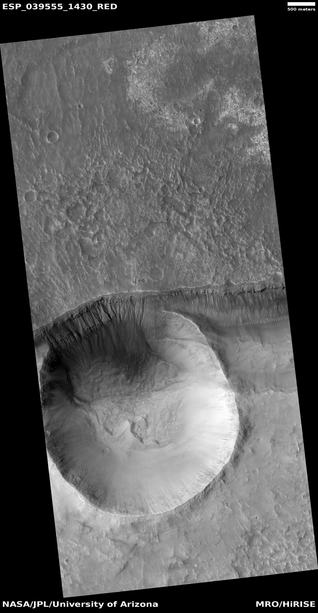
English: Image shows crater cutting across a trough. The north wall of crater contains gullies. This image was named HiRISE picture of the day for March 27, 2021. NASA wrote the following caption for this image: Gullies are commonly found in the southern mid-latitudes of Mars. In this image they start near top of a long ridge, and descend into an impact crater that lies at the bottom of the ridge, moving through a rocky layer along the way. Below the layer, the surface is dark and blue in HiRISE enhanced color, suggesting that it is easily erodible sand coating the crater wall.
The topography here is also interesting. There are two main features, an impact crater and a long trough called a graben, formed when the surface drops down between two faults. The eastern side of the crater is clearly cut by faulting, distorting the circular shape. On the north side, the crater rim is below the top of the graben fault. The crater could have dropped into the trough as it formed, but it is also possible that the trough partially formed before the crater and continued to widen later. Written by: HiRISE Science Team (narration: Tre Gibbs) (11 March 2015) |
| Date | |
| Source | https://www.uahirise.org/ESP_054891_2040 |
| Author | Jim Secosky selected pictures from NASA files. The credit should read NASA/JPL-Caltech/UArizona. |
| Location on Mars | View this and other nearby images on: Google Maps |
|---|
Licensing
This work is in the public domain in the United States because it is a work prepared by an officer or employee of the United States Government as part of that person’s official duties under the terms of Title 17, Chapter 1, Section 105 of the US Code.
Note: This only applies to original works of the Federal Government and not to the work of any individual U.S. state, territory, commonwealth, county, municipality, or any other subdivision. This template also does not apply to postage stamp designs published by the United States Postal Service since 1978. (See § 313.6(C)(1) of Compendium of U.S. Copyright Office Practices). It also does not apply to certain US coins; see The US Mint Terms of Use.
|
 | |
| This file has been identified as being free of known restrictions under copyright law, including all related and neighboring rights. | ||
| This file is in the public domain in the United States because it was solely created by NASA. NASA copyright policy states that "NASA material is not protected by copyright unless noted". (See Template:PD-USGov, NASA copyright policy page or JPL Image Use Policy.) | ||
 |
Warnings:
|
File history
Click on a date/time to view the file as it appeared at that time.
| Date/Time | Thumbnail | Dimensions | User | Comment | |
|---|---|---|---|---|---|
| current | 09:32, 29 December 2023 | | 1,024 × 1,970 (231 KB) | Jimmarsmars | Uploaded a work by Jim Secosky selected pictures from NASA files. The credit should read NASA/JPL-Caltech/UArizona. from https://www.uahirise.org/ESP_054891_2040 with UploadWizard |
File usage
The following page uses this file:


