File:False color of Hellas Planitia.jpeg

Size of this preview: 486 × 599 pixels. Other resolutions: 195 × 240 pixels | 389 × 480 pixels | 487 × 600 pixels | 623 × 768 pixels | 831 × 1,024 pixels | 1,909 × 2,353 pixels.
Original file (1,909 × 2,353 pixels, file size: 881 KB, MIME type: image/jpeg)
Summary
| Description |
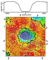
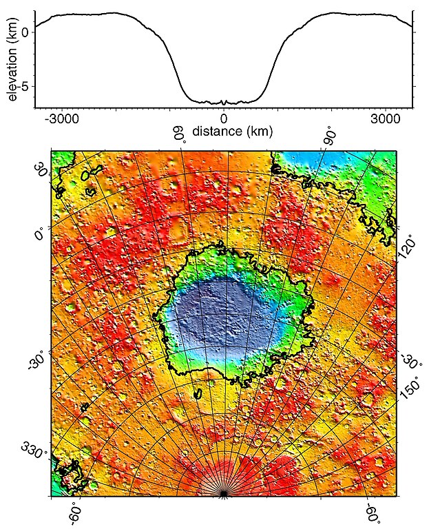
English: Regional topographic model of the Hellas basin (Hellas Planitia) taken by the MOLA instrument aboard the Mars Global Surveyor. (Top) Azimuthally-averaged radial topography used in the calculation of infilling the basin with surrounding material postulated to have been excavated from it. (Bottom) Color-coded topography plotted in an equal-area projection. The black lines correspond to zero-elevation contours. |
| Date | |
| Source | http://photojournal.jpl.nasa.gov/catalog/PIA02033 |
| Author | NASA/JPL/GSFC |
Licensing
| This file is in the public domain in the United States because it was solely created by NASA. NASA copyright policy states that "NASA material is not protected by copyright unless noted". (See Template:PD-USGov, NASA copyright policy page or JPL Image Use Policy.) | ||
 |
Warnings:
|
File history
Click on a date/time to view the file as it appeared at that time.
| Date/Time | Thumbnail | Dimensions | User | Comment | |
|---|---|---|---|---|---|
| current | 11:51, 19 December 2010 | | 1,909 × 2,353 (881 KB) | Orionist | high res version from original source |
File usage
The following page uses this file:


