File:Maadim Vallis.JPG
No higher resolution available.
Maadim_Vallis.JPG (205 × 489 pixels, file size: 19 KB, MIME type: image/jpeg)
Summary
| Description |
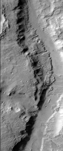
English: Ma'adim Vallis as seen by HiRISE. The location is 20.58 degrees south latitude and 182.58 degrees west longitude. Picture was taken with the Mars Reconnaissance Orbiter's HiRISE. Picture credit is NASA/JPL/ University of Arizona. |
| Date | |
| Source | http://globaldata.mars.asu.edu/ctx/P02_001922_1595_XN_20S182W |
| Author | Jim Secosky modified NASA image. |
Licensing
| This file is in the public domain in the United States because it was solely created by NASA. NASA copyright policy states that "NASA material is not protected by copyright unless noted". (See Template:PD-USGov, NASA copyright policy page or JPL Image Use Policy.) | ||
 |
Warnings:
|
File history
Click on a date/time to view the file as it appeared at that time.
| Date/Time | Thumbnail | Dimensions | User | Comment | |
|---|---|---|---|---|---|
| current | 08:43, 16 February 2009 | | 205 × 489 (19 KB) | Jimmarsmars | {{Information |Description=Ma'adim Vallis s seen by HiRISE. The location is 20.58 degrees south latitude and 177.42 degrees east longitude. |Source=http://globaldata.mars.asu.edu/ctx/P02_001922_1595_XN_20S182W |Date=February 16, 2009 |Author=Jim Secosk |
File usage
The following file is a duplicate of this file (more details):
There are no pages that use this file.


