File:Meanderingridgeswide ESP 079382 1735 01.jpg
Original file (2,048 × 6,230 pixels, file size: 3.2 MB, MIME type: image/jpeg)
Summary
| Description |
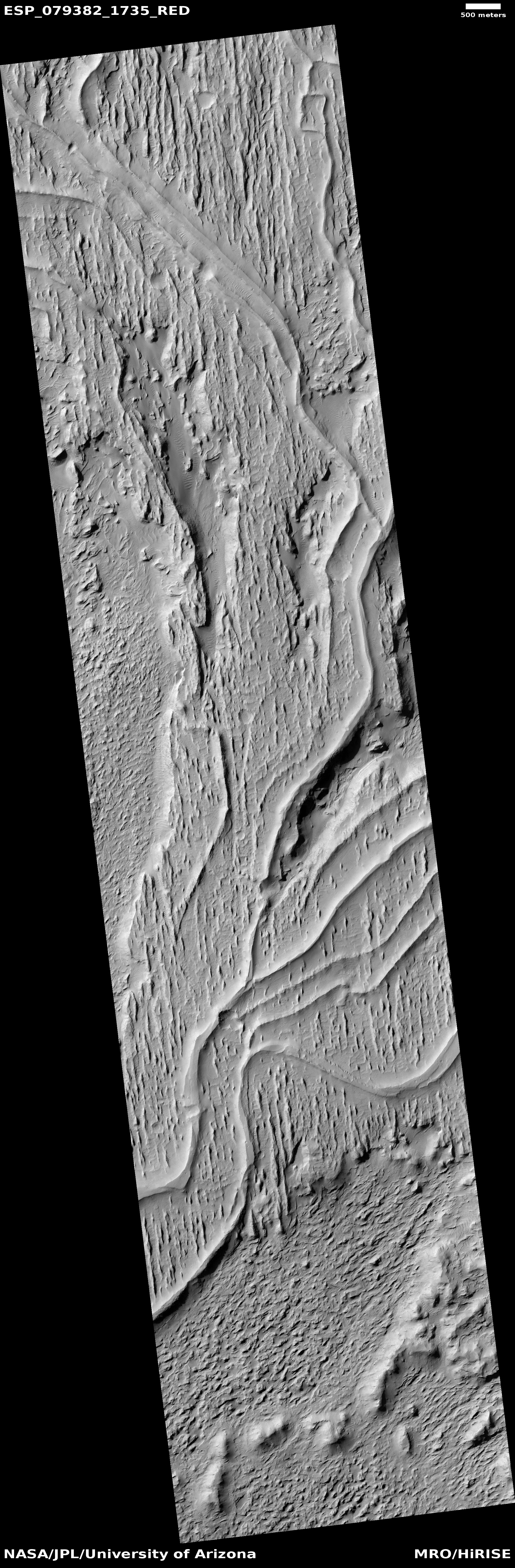
English: These ridges were once streams that became inverted over time. NASA has this to say about the image: Multiple processes, which may have occurred billions of years apart, are reflected in this HiRISE image of Aeolis Planum.
Cutting across the scene are curvilinear ridges. These likely represent ancient, meandering river channels that flowed across the surface and buried themselves over time. The channels have subsequently been exposed to the surface by the wind, forming the cross-cutting ridges. Approximately north-south across the image are a series of linear ridges called “yardangs,” which are streamlined landforms that also form due to wind-driven erosion. The orientation of the yardangs reflects the prevailing wind direction when they formed. Both sets of ridges emerged from the preferential removal of softer bedrock by the wind. Written by: Joel Davis (13 December 2023) |
| Date | Multiple processes, which may have occurred billions of years apart, are reflected in this HiRISE image of Aeolis Planum. Cutting across the scene are curvilinear ridges. These likely represent ancient, meandering river channels that flowed across the surface and buried themselves over time. The channels have subsequently been exposed to the surface by the wind, forming the cross-cutting ridges. Approximately north-south across the image are a series of linear ridges called “yardangs,” which are streamlined landforms that also form due to wind-driven erosion. The orientation of the yardangs reflects the prevailing wind direction when they formed. Both sets of ridges emerged from the preferential removal of softer bedrock by the wind. Written by: Joel Davis (13 December 2023) |
| Source | https://www.uahirise.org/ESP_079382_1735 |
| Author | Jim Secosky selected pictures from NASA files. This image was named HiRISE picture of the day for December 13, 2023. The credit should read NASA/JPL-Caltech/UArizona. |
| Location on Mars | View this and other nearby images on: Google Maps |
|---|
Licensing
| This file is in the public domain in the United States because it was solely created by NASA. NASA copyright policy states that "NASA material is not protected by copyright unless noted". (See Template:PD-USGov, NASA copyright policy page or JPL Image Use Policy.) | ||
 |
Warnings:
|
File history
Click on a date/time to view the file as it appeared at that time.
| Date/Time | Thumbnail | Dimensions | User | Comment | |
|---|---|---|---|---|---|
| current | 06:48, 13 December 2023 | 2,048 × 6,230 (3.2 MB) | Jimmarsmars | Uploaded a work by Jim Secosky selected pictures from NASA files. This image was named HiRISE picture of the day for December 13, 2023. The credit should read NASA/JPL-Caltech/UArizona. from https://www.uahirise.org/ESP_079382_1735 with UploadWizard |
File usage
The following page uses this file:


