File:Maadim Vallis.jpg
No higher resolution available.
Maadim_Vallis.jpg (205 × 489 pixels, file size: 19 KB, MIME type: image/jpeg)
Summary
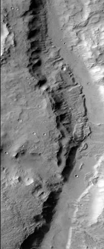
Ma'adim Vallis as seen by HiRISE. The location is 20.58 degrees south latitude and 182.58 degrees west longitude. Picture was taken with the Mars Reconnaissance Orbiter's HiRISE.
Source:http://globaldata.mars.asu.edu/ctx/P02_001922_1595_XN_20S182W
Picture credit is NASA/JPL/ University of Arizona.
Licensing
Public domain images are available for anybody to use without any licenses, royalties, or special permissions.
File history
Click on a date/time to view the file as it appeared at that time.
| Date/Time | Thumbnail | Dimensions | User | Comment | |
|---|---|---|---|---|---|
| current | 08:36, 1 March 2018 | | 205 × 489 (19 KB) | Suitupandshowup (talk | contribs) | Ma'adim Vallis as seen by HiRISE. The location is 20.58 degrees south latitude and 182.58 degrees west longitude. Picture was taken with the Mars Reconnaissance Orbiter's HiRISE. Source:http://globaldata.mars.asu.edu/ctx/P02_001922_1595_XN_20S182W... |
You cannot overwrite this file.
File usage
The following file is a duplicate of this file (more details):
- File:Maadim Vallis.JPG from Wikimedia Commons
The following page uses this file:


