File:PIA16068 - Mars Curiosity Rover - Aeolis Mons - 20120817.jpg
PIA16068_-_Mars_Curiosity_Rover_-_Aeolis_Mons_-_20120817.jpg (800 × 381 pixels, file size: 65 KB, MIME type: image/jpeg)
Summary
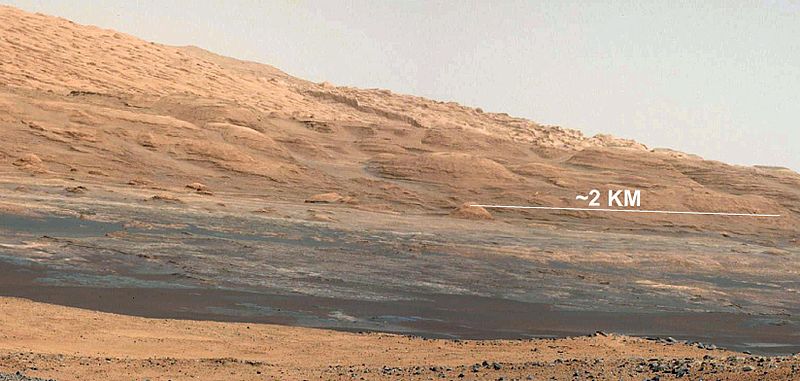
he Promised Land This image (cut out from a mosaic) shows the view from the landing site of NASA's Curiosity rover toward the lower reaches of Mount Sharp, where Curiosity is likely to begin its ascent through hundreds of feet (meters) of layered deposits. The lower several hundred feet (meters) show evidence of bearing hydrated minerals, based on orbiter observations. The terrain Curiosity will explore is marked by hills, buttes, mesas and canyons on the scale of one-to-three story buildings, very much like the Four Corners region of the western United States.
A scale bar indicates a distance of 1.2 miles (2 kilometers).
Curiosity's 34-millimeter Mast Camera acquired this high-resolution image on Aug. 8, 2012 PDT (Aug. 9 EDT).
This image shows the colors modified as if the scene were transported to Earth and illuminated by terrestrial sunlight. This processing, called "white balancing," is useful to scientists for recognizing and distinguishing rocks by color in more familiar lighting.
Image Credit: NASA/JPL-Caltech/MSSS
Source https://photojournal.jpl.nasa.gov/catalog/PIA16068
NASA/JPL-Caltech/MSSS
Licensing
Public domain images are available for anybody to use without any licenses, royalties, or special permissions.
File history
Click on a date/time to view the file as it appeared at that time.
| Date/Time | Thumbnail | Dimensions | User | Comment | |
|---|---|---|---|---|---|
| current | 16:49, 25 January 2019 | | 800 × 381 (65 KB) | Suitupandshowup (talk | contribs) | he Promised Land This image (cut out from a mosaic) shows the view from the landing site of NASA's Curiosity rover toward the lower reaches of Mount Sharp, where Curiosity is likely to begin its ascent through hundreds of feet (meters) of layered depos... |
You cannot overwrite this file.
File usage
The following page uses this file:


