File:PIA23514-Mars-WaterIce-LikeliestAreas-20191210.jpg

Size of this preview: 800 × 357 pixels. Other resolutions: 320 × 143 pixels | 640 × 286 pixels | 1,614 × 720 pixels.
Original file (1,614 × 720 pixels, file size: 304 KB, MIME type: image/jpeg)
Summary
| Description |
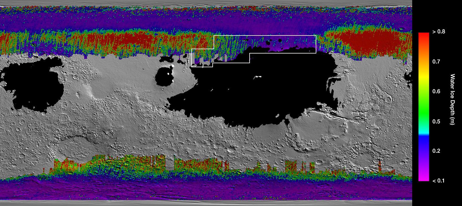
English: A Water Ice Map for Mars
https://www.jpl.nasa.gov/spaceimages/details.php?id=PIA23514 This rainbow-colored map shows underground water ice on Mars. This rainbow-colored map shows underground water ice on Mars. Cool colors represent less than one foot (30 centimeters) below the surface; warm colors are over two feet (60 centimeters) deep. Sprawling black zones on the map represent areas where a landing spacecraft would sink into fine dust. The outlined box represents the ideal region to send astronauts for them to be able to dig up water ice. The map was created by combining data from multiple NASA orbiters, including the Mars Reconnaissance Orbiter and its Mars Climate Sounder instrument; Mars Odyssey and its Thermal Emission Imaging System; and the Mars Global Surveyor. |
| Date | |
| Source | https://photojournal.jpl.nasa.gov/jpeg/PIA23514.jpg |
| Author | NASA/JPL-Caltech/ASU |
Licensing
| This file is in the public domain in the United States because it was solely created by NASA. NASA copyright policy states that "NASA material is not protected by copyright unless noted". (See Template:PD-USGov, NASA copyright policy page or JPL Image Use Policy.) | ||
 |
Warnings:
|
File history
Click on a date/time to view the file as it appeared at that time.
| Date/Time | Thumbnail | Dimensions | User | Comment | |
|---|---|---|---|---|---|
| current | 17:53, 10 December 2019 | | 1,614 × 720 (304 KB) | Drbogdan | User created page with UploadWizard |
File usage
There are no pages that use this file.


