File list
This special page shows all uploaded files.
| Date | Name | Thumbnail | Size | User | Description | Versions |
|---|---|---|---|---|---|---|
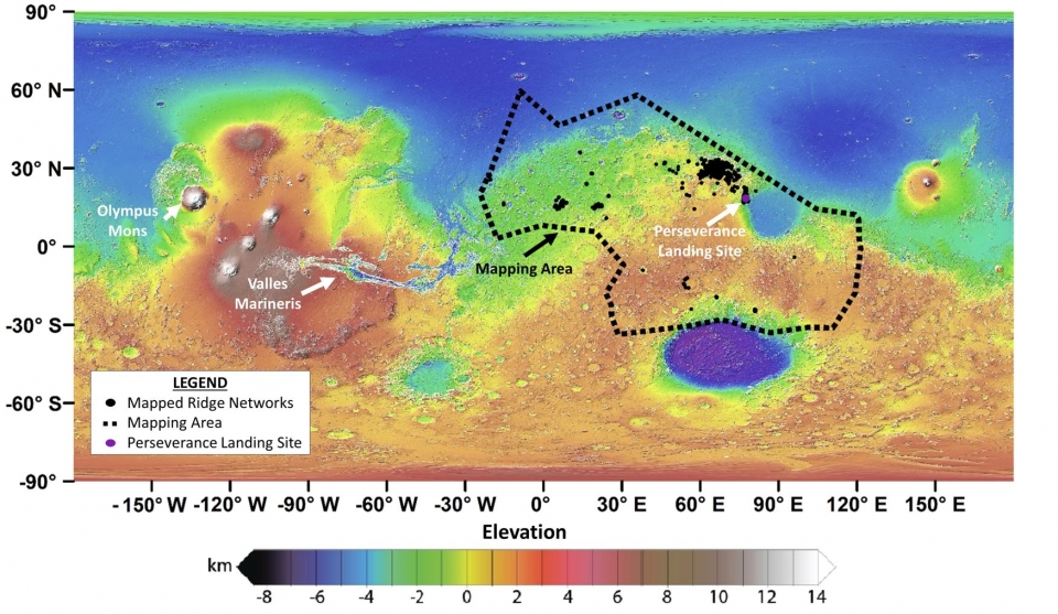
| 06:53, 22 September 2022 | Ridgesmappedbycitizens.jpg (file) |  |
451 KB | Suitupandshowup | Map of ridges that were mapped by citizen scientists. Source: https://news.asu.edu/20220405-citizen-scientists-help-map-ridge-networks-may-hold-records-ancient-groundwater-mars Credit: NASA/JPL/GSFC. | 1 |
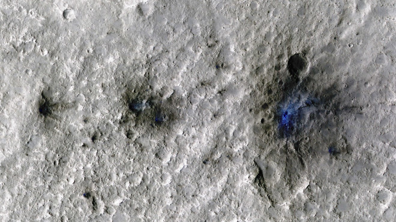
| 13:21, 20 September 2022 | Insightimpacecrater.jpg (file) |  |
269 KB | Suitupandshowup | Craters that Insight heard. From insight's observations scientists were able to take this picture of the impacts. its was taken with HiRISE. Source: https://www.jpl.nasa.gov/news/nasas-insight-hears-its-first-meteoroid-impacts-on-mars?utm_source=iContact&utm_medium=email&utm_campaign=nasajpl&utm_content=Daily09192022 Image credit: NASA/JPL-Caltech/university of Arizona | 1 |
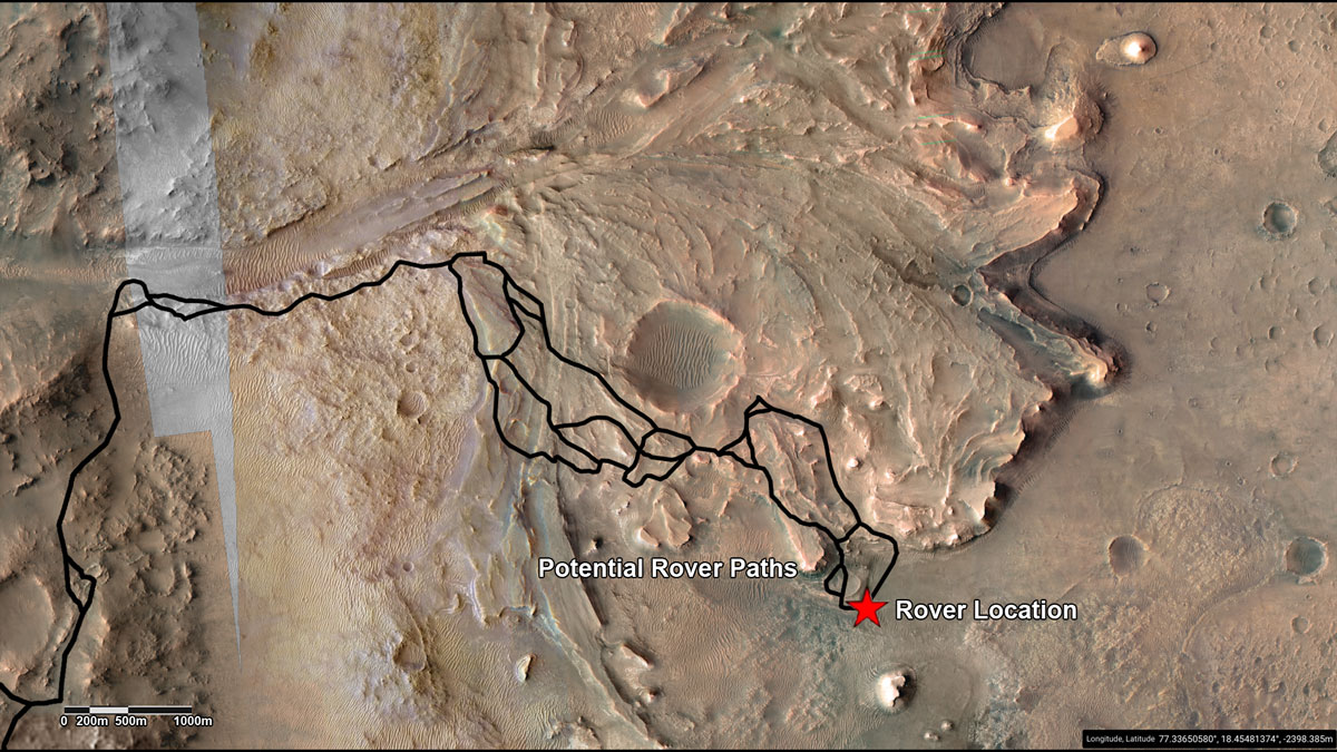
| 14:45, 16 September 2022 | Perseverancefuturepath26993 PIA25244-web.jpg (file) |  |
239 KB | Suitupandshowup | NASA/JPL-Caltech/University of Arizona/USGS/JHU-APL | 1 |
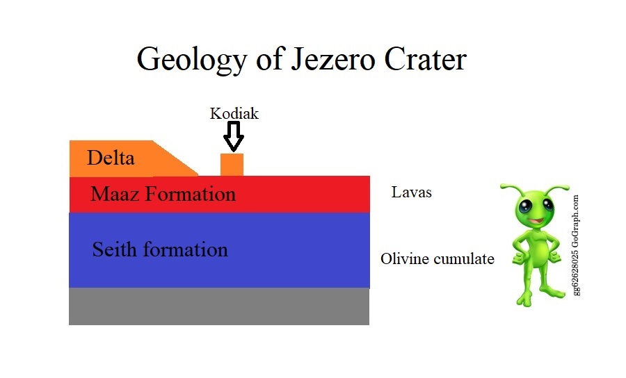
| 17:51, 30 August 2022 | Diagramjezerolabeled2.jpg (file) |  |
54 KB | Suitupandshowup | Diagram of what we know about rocks in Jezero as of August 2022. Image credit: Secosky | 1 |
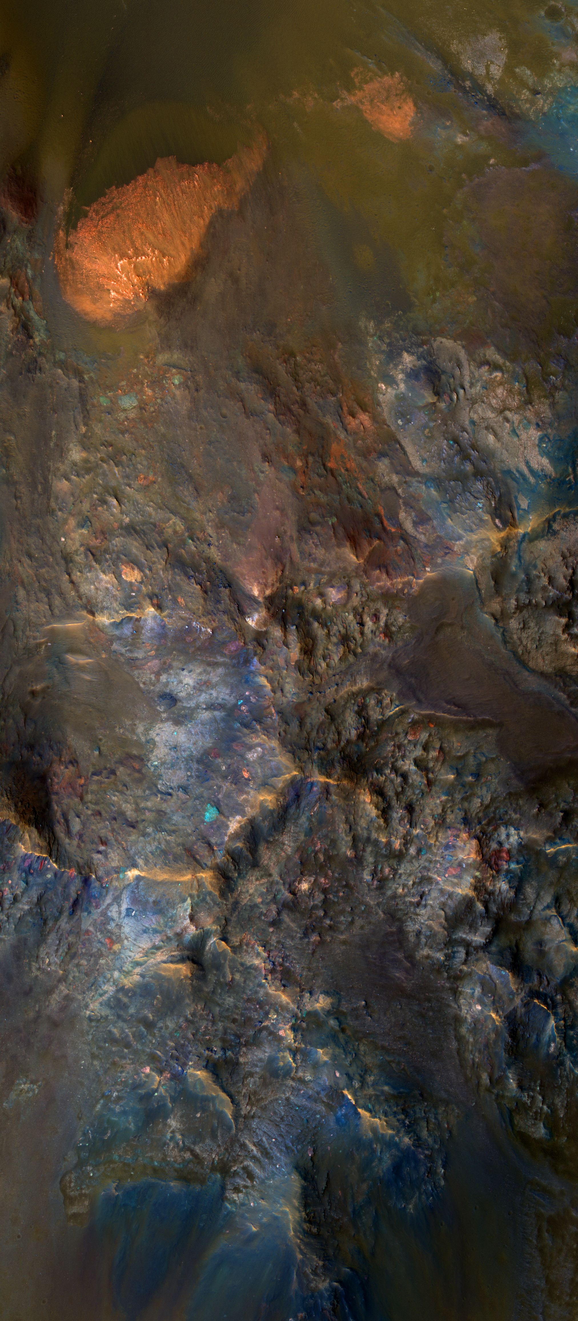
| 08:14, 16 July 2022 | ESP 013514 1630centralcolors.jpg (file) |  |
10.95 MB | Suitupandshowup | https://static.uahirise.org/images/2017/details/cut/ESP_013514_1630.jpg | 1 |
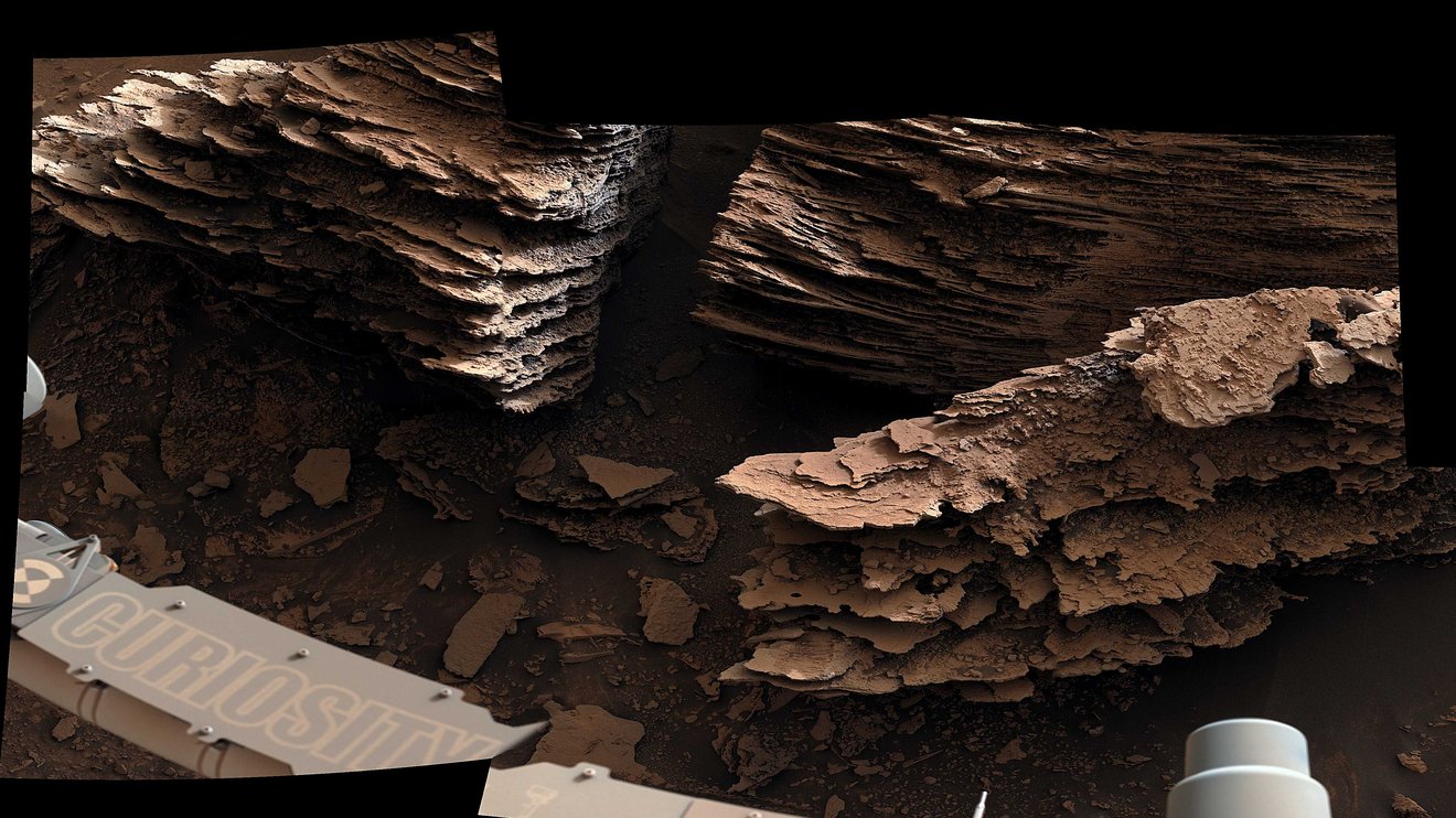
| 09:03, 23 June 2022 | Curiosityflakes.jpg (file) |  |
215 KB | Suitupandshowup | Thin layers in Gale crater as seen by curiosity. They may have formed in a pond or stream. Source: https://www.jpl.nasa.gov/news/nasas-curiosity-captures-stunning-views-of-a-changing-mars-landscape?utm_source=iContact&utm_medium=email&utm_campaign=nasajpl&utm_content=daily20220622-1 Credit: NASA/JPL-Caltech/MSSS | 1 |
| 12:08, 12 June 2022 | 2021 TMS Conv Art.jpg (file) |  |
78 KB | Jburk | 1 | |
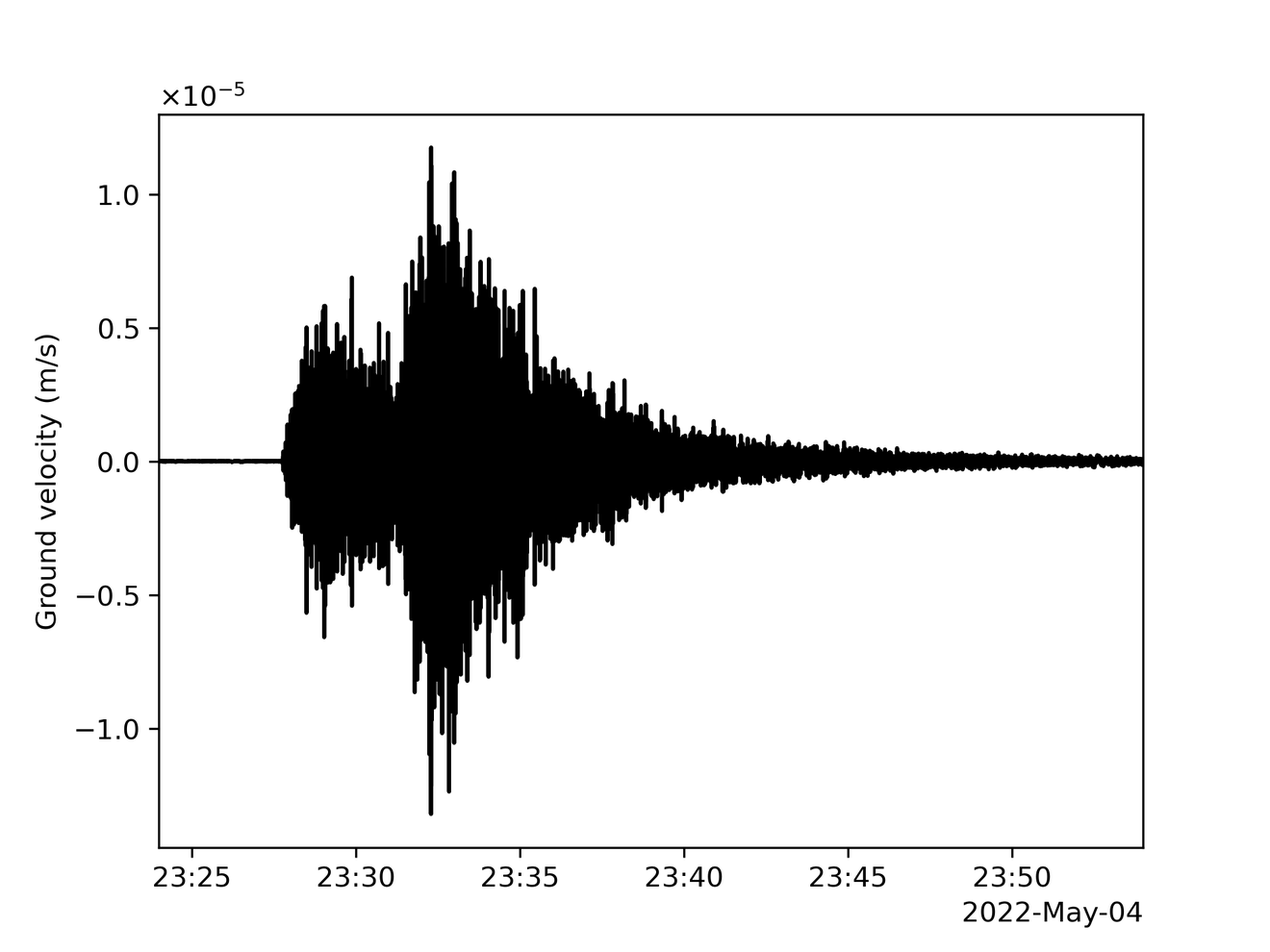
| 15:10, 13 May 2022 | InSights Seismogramm5.png (file) |  |
92 KB | Suitupandshowup | Seismogram of largest quake detected as of May, 2022. Quake was magnitude 5. Source: https://www.jpl.nasa.gov/news/nasas-insight-records-monster-quake-on-mars?utm_source=iContact&utm_medium=email&utm_campaign=nasajpl&utm_content=daily20220509-1 Image Credit: NASA/JPL-Caltech | 1 |
| 17:58, 4 April 2022 | Burroughsctx2.jpg (file) |  |
56 KB | Suitupandshowup | CTX image of eastern part of Burroughs Crater. Source: http://viewer.mars.asu.edu/planetview/inst/ctx/D10_031013_1078_XN_72S241W#P=D10_031013_1078_XN_72S241W&T=2 Credit: NASA/MSSS | 1 |
| 08:15, 4 April 2022 | Burroughsthemis.jpg (file) |  |
58 KB | Suitupandshowup | Themis image of part of Burroughs Crater. Source: https://viewer.mars.asu.edu//planetview/inst/themis/I15723005#P=I15723005&T=2 Image credit: NASA/JPL-Caltech/Arizona State University. | 1 |
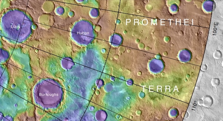
| 07:51, 4 April 2022 | Burroughscratertopo.jpg (file) |  |
162 KB | Suitupandshowup | Topo map showing Burroughs Crater and other nearby features. Source:https://planetarynames.wr.usgs.gov/images/mc30_2014.pdf Credit: NASA/USGS/Secosky | 1 |
| 18:05, 2 April 2022 | Burroughslayers.jpg (file) |  |
408 KB | Suitupandshowup | http://viewer.mars.asu.edu/planetview/inst/ctx/D10_031013_1078_XN_72S241W#P=D10_031013_1078_XN_72S241W&T=2 | 1 |
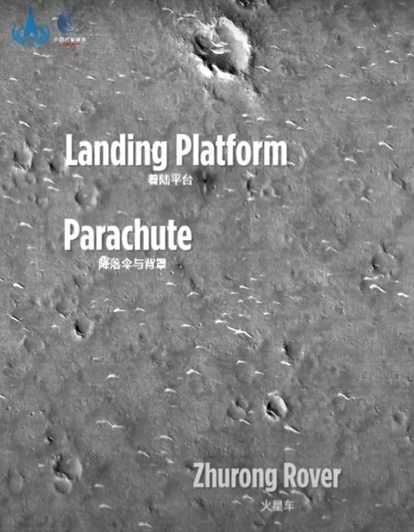
| 07:47, 31 March 2022 | Chinaimagerover.jpg (file) |  |
142 KB | Suitupandshowup | This undated, annotated photo from China's Tianwen 1 Mars orbiter shows the nation's Zhurong rover and some of the hardware that helped it land safely in May 2021. Image credit: CNSA via CCTV+ Source: https://www.space.com/china-tianwen-1-perseverance-zhurong-mars-rovers-photos | 1 |
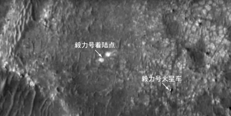
| 07:39, 31 March 2022 | Chinaimage.jpg (file) |  |
106 KB | Suitupandshowup | China's Tianwen 1 Mars orbiter captured this photo of NASA's Perseverance rover (bottom right) on the Red Planet's surface on March 7, 2022. The other arrow, closer to the center of the frame, points out Perseverance's landing area. Image credit: CNSA via CCTV+ Source: https://www.space.com/china-tianwen-1-perseverance-zhurong-mars-rovers-photos | 1 |
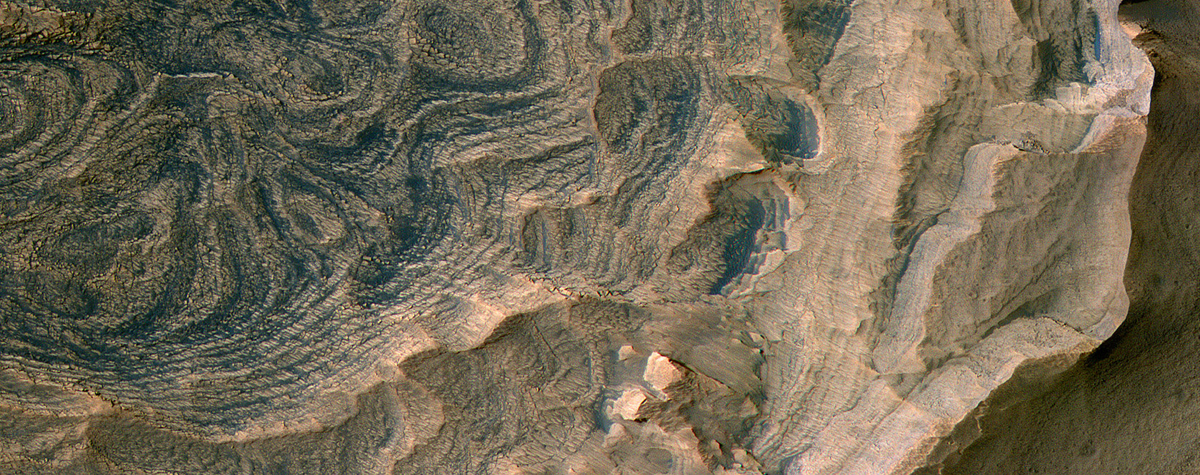
| 07:54, 18 March 2022 | ESP 072599 1735candor.jpg (file) |  |
962 KB | Suitupandshowup | Close view of Candor Chasma layers, as seen by HiRISE Source: https://www.uahirise.org/ESP_072599_1735 Credit: NASA/JPL/University of Arizona | 1 |
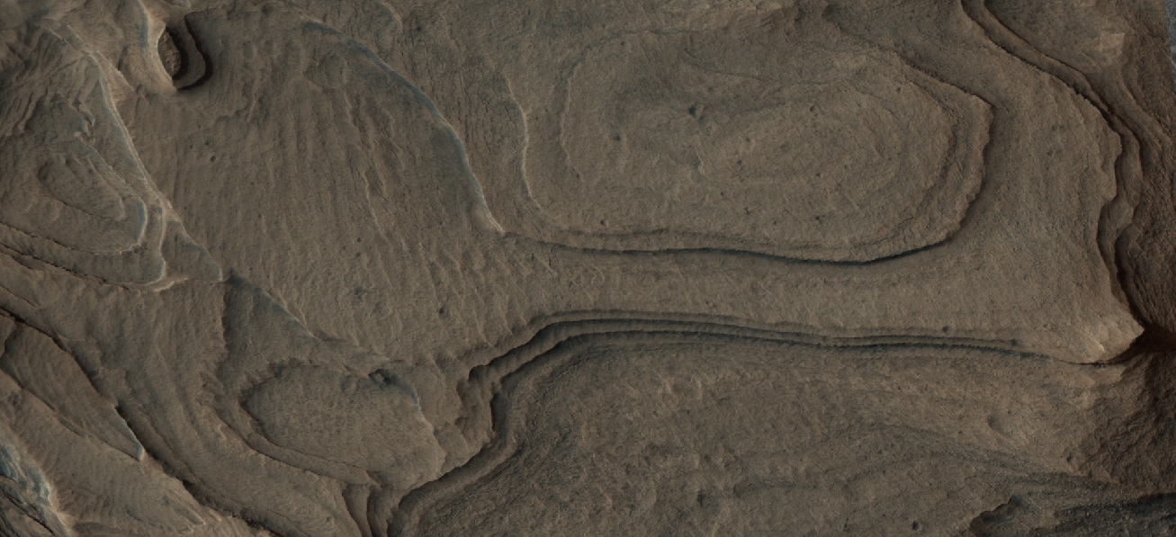
| 07:53, 18 March 2022 | 72599 1735CandorChasmargb.jpg (file) |  |
254 KB | Suitupandshowup | Candor Chasma layers, as seen by HiRISE Source: https://www.uahirise.org/ESP_072599_1735 Credit: NASA/JPL/University of Arizona | 1 |
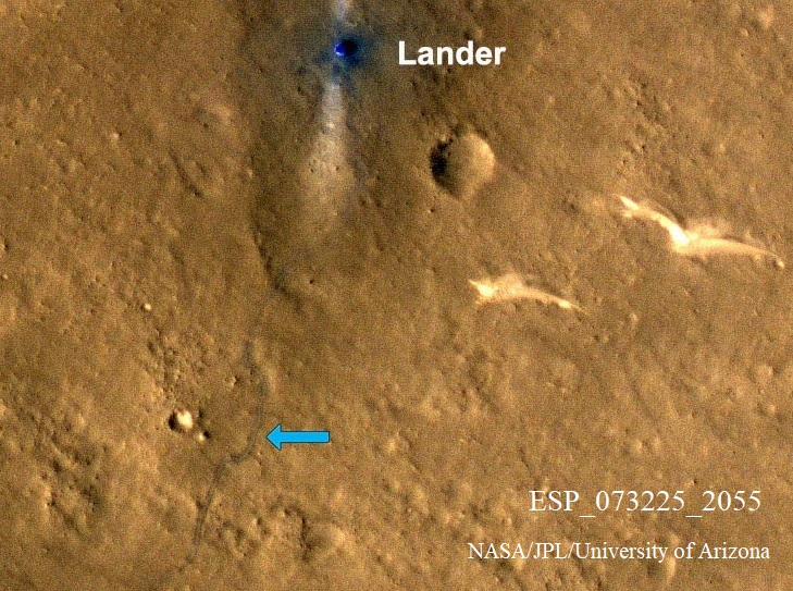
| 06:18, 18 March 2022 | ZhurongChina.jpg (file) |  |
217 KB | Suitupandshowup | Zhurong, as seen by HiRISE. The Chinese Zhurong rover landed on Mars in May 2021. (It was 14 May in the United States, but 15 May China.) This HiRISE image was acquired on 11 March 2022. Its wheel tracks left on the surface are indicated with blue arrow. Source: https://www.uahirise.org/hipod/ESP_073225_2055 Image credit: NASA/JPL/University of Arizona | 1 |
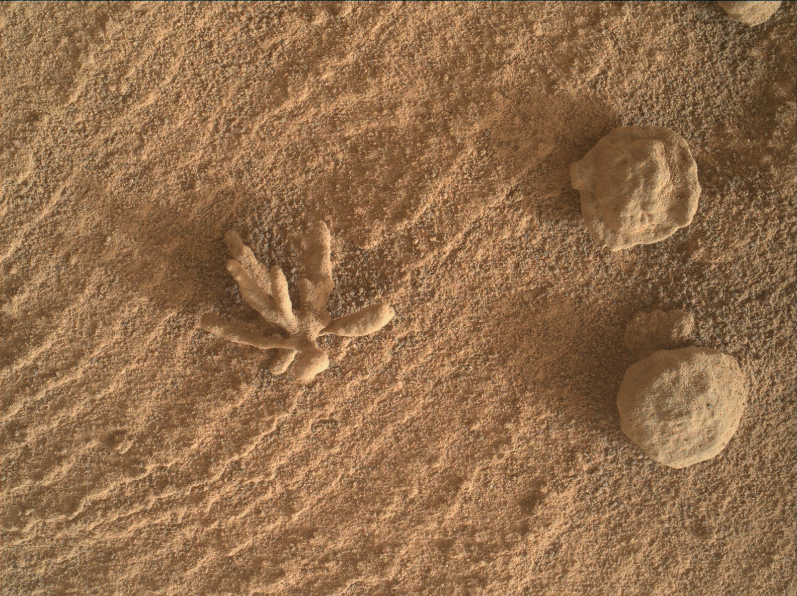
| 17:02, 3 March 2022 | Curiosityblackthorn.jpg (file) |  |
1,010 KB | Suitupandshowup | Feature called "Blackthorn" as seen by Curiosity in Gale Crater. It was a type of concretion. Source: https://mars.nasa.gov/raw_images/1029787/?site=msl Image Credit: NASA/JPL-Caltech/MSSS | 1 |
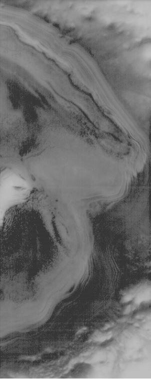
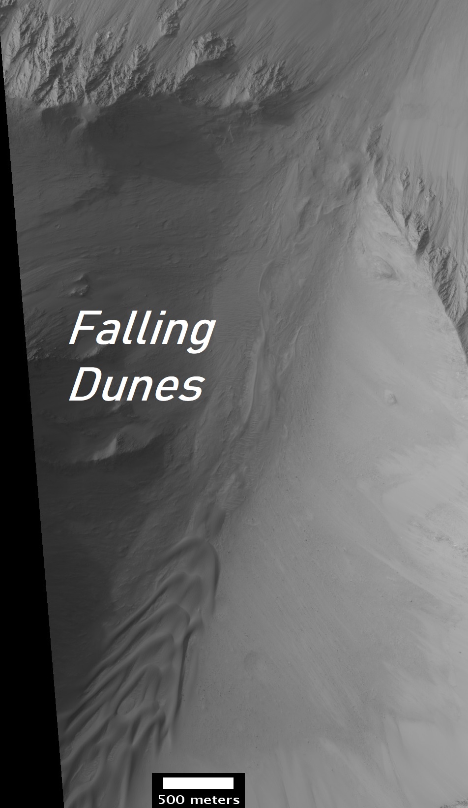
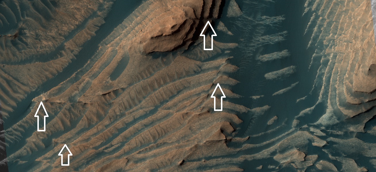
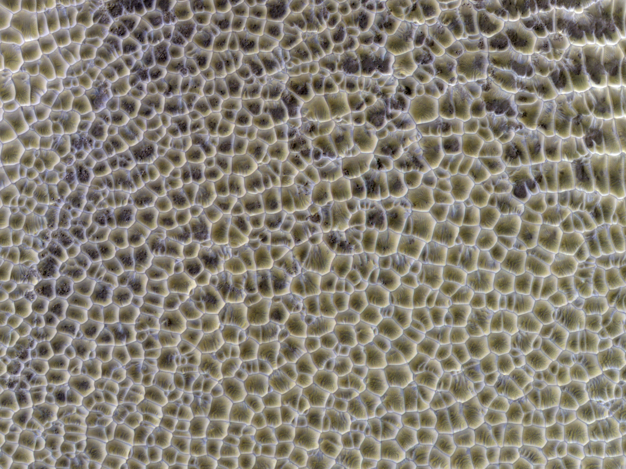
| 06:42, 24 January 2022 | PSP 010277 1650fallingdunes.croppedjpg.jpg (file) |  |
257 KB | Suitupandshowup | Falling dunes, as seen by HiRISE. Source: https://www.uahirise.org/PSP_010277_1650 Image credit: NASA/JPL/University of Arizona/Secosky This image shows a transect of approximately 8-kilometers of Coprates Chasma wall stratigraphy, which includes (moving down sequence): the southern plateau, wall spurs, fans of eroded material, gullies, sand dunes, and canyon floor. Dunes located in the center left show slip faces on the downhill side and aligned with the local gradient, indicating down sl... | 1 |
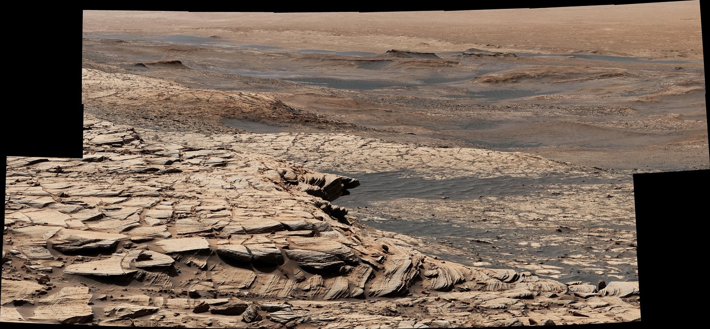
| 16:56, 20 January 2022 | CuriosityjpegPIA23974.width-1440.jpg (file) |  |
284 KB | Suitupandshowup | Stitched together from 28 images, this view from NASA's Curiosity Mars rover was captured on April 9, 2020, the 2,729th Martian day, or sol, of the mission after the rover ascended a steep slope, part of a geologic feature called "Greenheugh Pediment." In the foreground is the crusty sandstone cap that stretches the length of the pediment, forming an overhanging ledge in some parts. At center is the "clay-bearing unit," a region with a unique story to tell about the history of water on Mount... | 1 |
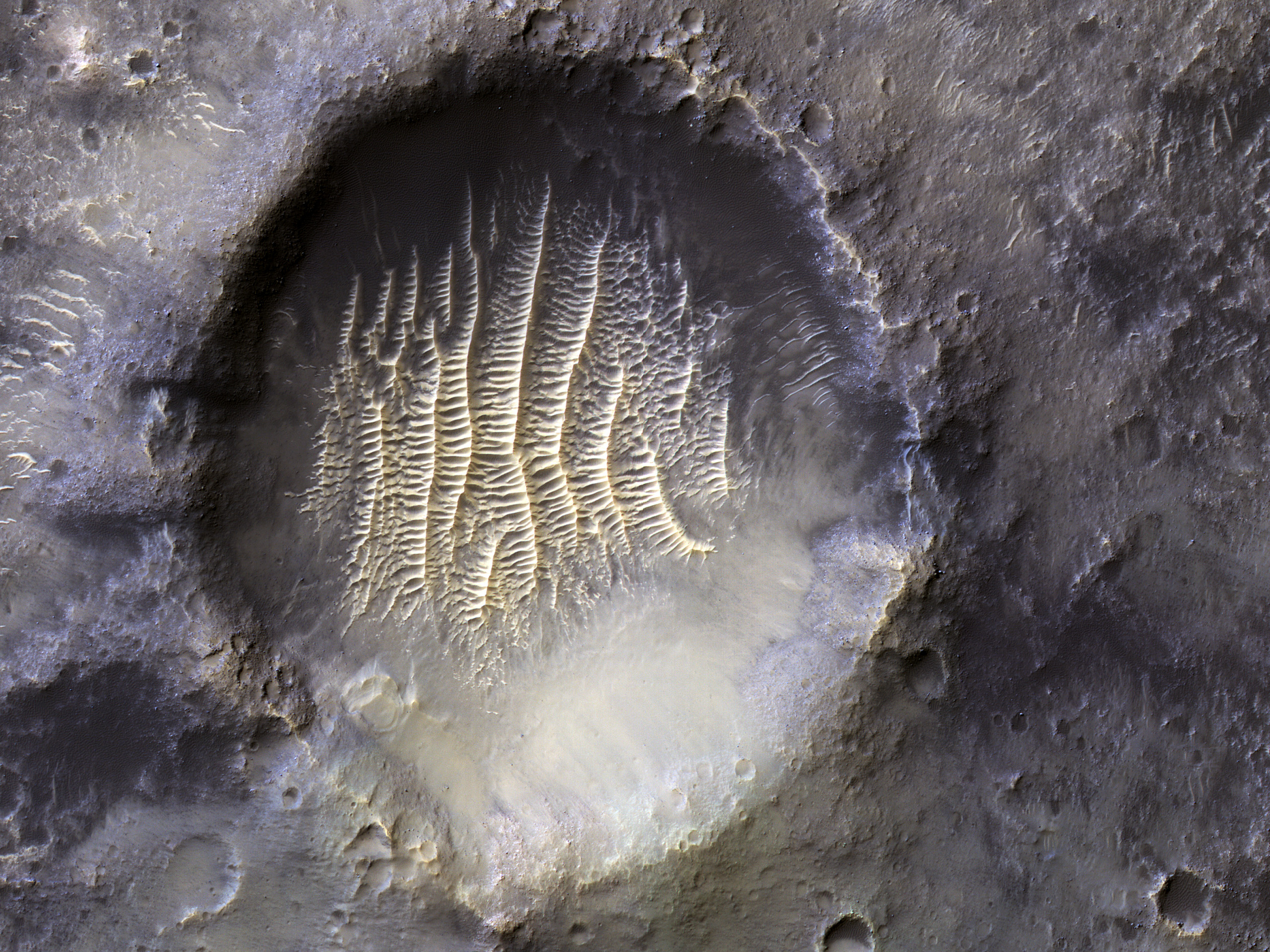
| 09:04, 20 January 2022 | ESP 071502 1750longitudecrater.jpg (file) |  |
1.88 MB | Suitupandshowup | Crater at the zero longitude on Mars, as seen by HiRISE Source: hirise.lpl.arizona.edu/ESP_071502_1750 Image credit: NASA/JPL/University of Arizona/ | 1 |
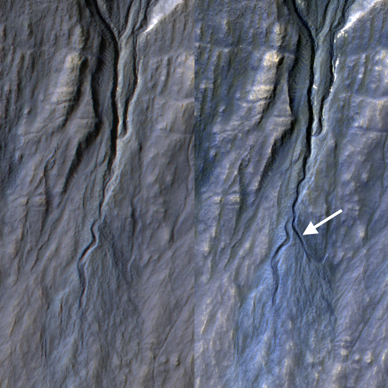
| 07:15, 13 January 2022 | 71634 1880layersfaultslabeled.jpg (file) |  |
293 KB | Suitupandshowup | Faults in layered terrain, as seen by HiRISE under HiWish program Some faults are indicated with white arrow. The location is Danielson Crater in the Oxia Palus quadrangle at 7.688 N and 353.101 E (ESP_071634_1880). Source: hirise.lpl.arizona.edu/ESP_071634_1880 Image credit: NASA/JPL/University of Arizona/Secosky | 1 |
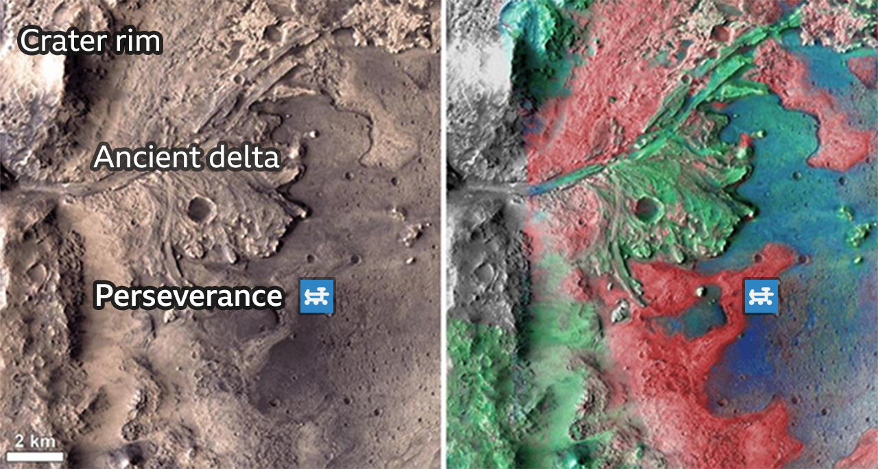
| 09:24, 18 December 2021 | Perseveranceseith 122237583 map-nc.png (file) |  |
1.51 MB | Suitupandshowup | Map showing distribution of minerals in Jezero delta. Source: https://www.bbc.com/news/science-environment-59677383 Image credit: ASAA/JPL_CALTECH/MSSS | 1 |
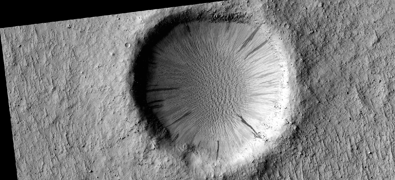
| 09:42, 22 November 2021 | ESP 046876 1465secondarycraters.jpg (file) |  |
401 KB | Suitupandshowup | This image of a southern mid-latitude crater was intended to investigate the lineated material on the crater floor. At the higher resolution of HiRISE, the image reveals a landscape peppered by small impact craters. These craters range from about 30 meters in diameter down to the resolution limit (about 2 meter diameter in this image acquired by averaging 2 by 2 picture elements). Such dense clusters of small craters are frequently formed by secondary craters, caused by the impact of materia... | 1 |
| 11:11, 31 October 2021 | ESP 032011 1425newgullies.jpg (file) |  |
790 KB | Suitupandshowup | Changes in gullies, as seen by HiRISE This observation is evidence that something other than flowing water can make gullies. Observations like this show that gullies are forming today. Although we cannot pin down the season of this event, locations where HiRISE has been able to image more often demonstrate that this sort of event generally occurs in the winter, when liquid water is very unlikely. Despite their resemblance to water-formed ravines on Earth, carbon dioxide may play a key role... | 1 |
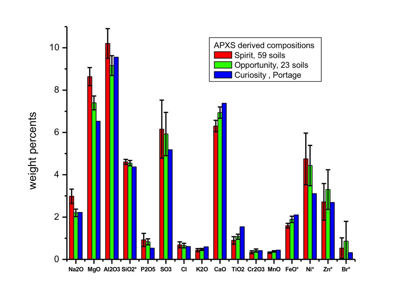
| 18:30, 17 October 2021 | Jpl nasa gov jpegPIA16572.width-1280.jpg (file) |  |
93 KB | Kee.nethery | Image from ppl.nasa.gov report https://www.jpl.nasa.gov/images/inspecting-soils-across-mars Note: SiO2 and FeO numbers displayed have been divided by 10 so they'll fit on the chart, and Ni, Zn, and Br numbers have been multiplied by 100 to show up on the chart. The Spirit and Opportunity deviation bars show the deviations in the various samples that were taken. Only one sample was taken with Curiosity. | 1 |
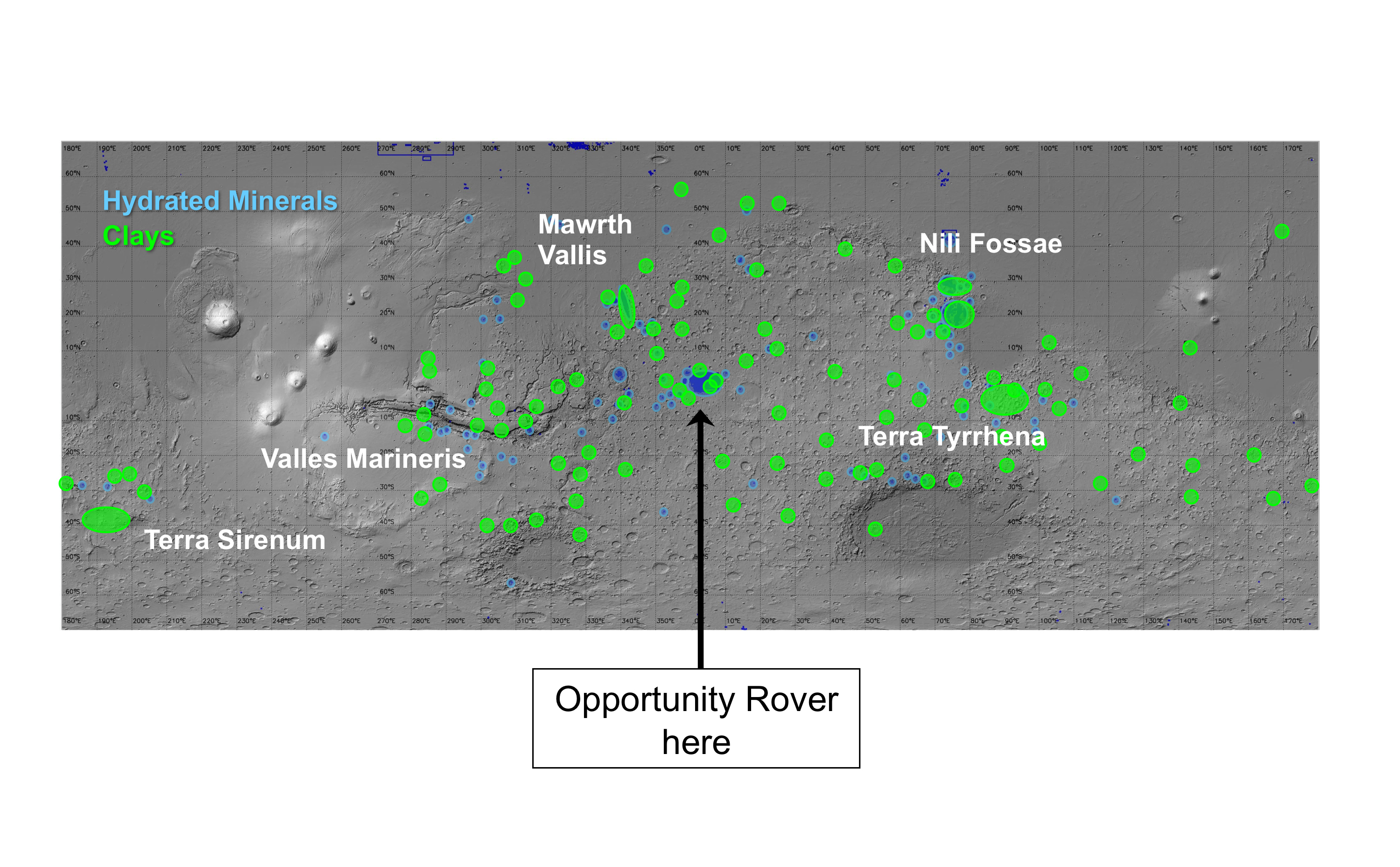
| 16:21, 13 October 2021 | Claymap.jpg (file) |  |
2.25 MB | Suitupandshowup | Map showing locations where clays and hydrated minerals have been found on Mars. Clay needs water to form and it is good for preserving fossils and organic material. Image Credit: NASA/JPL-Caltech/JHU-APL Source:https://mars.nasa.gov/resources/3433/regions-of-mars-with-clays-and-hydrated-minerals-identified-from-orbit/ | 1 |
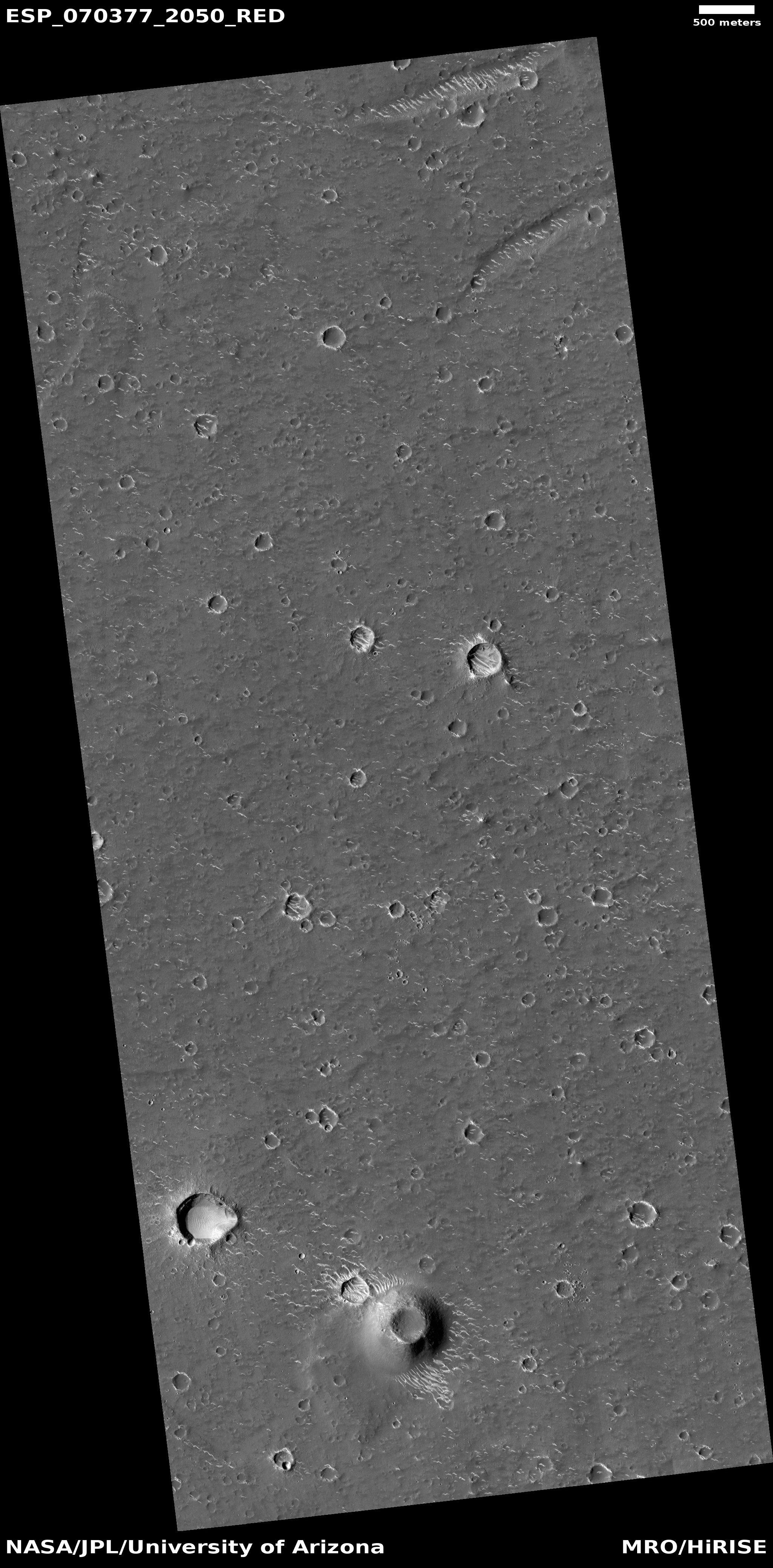
| 06:57, 23 September 2021 | ESP 070377 2050chinawide.jpg (file) |  |
1.92 MB | Suitupandshowup | Wide view of landscape near China's lander, as seen by HiRISE The lander is called Zhurong and is in Utopia Planitia The scale bar at the top is 500 meters long. Source: HiRISE.lpl.arizona.edu/ESP_070377_2050 Image credit: NASA/JPL/University of Arizona | 1 |
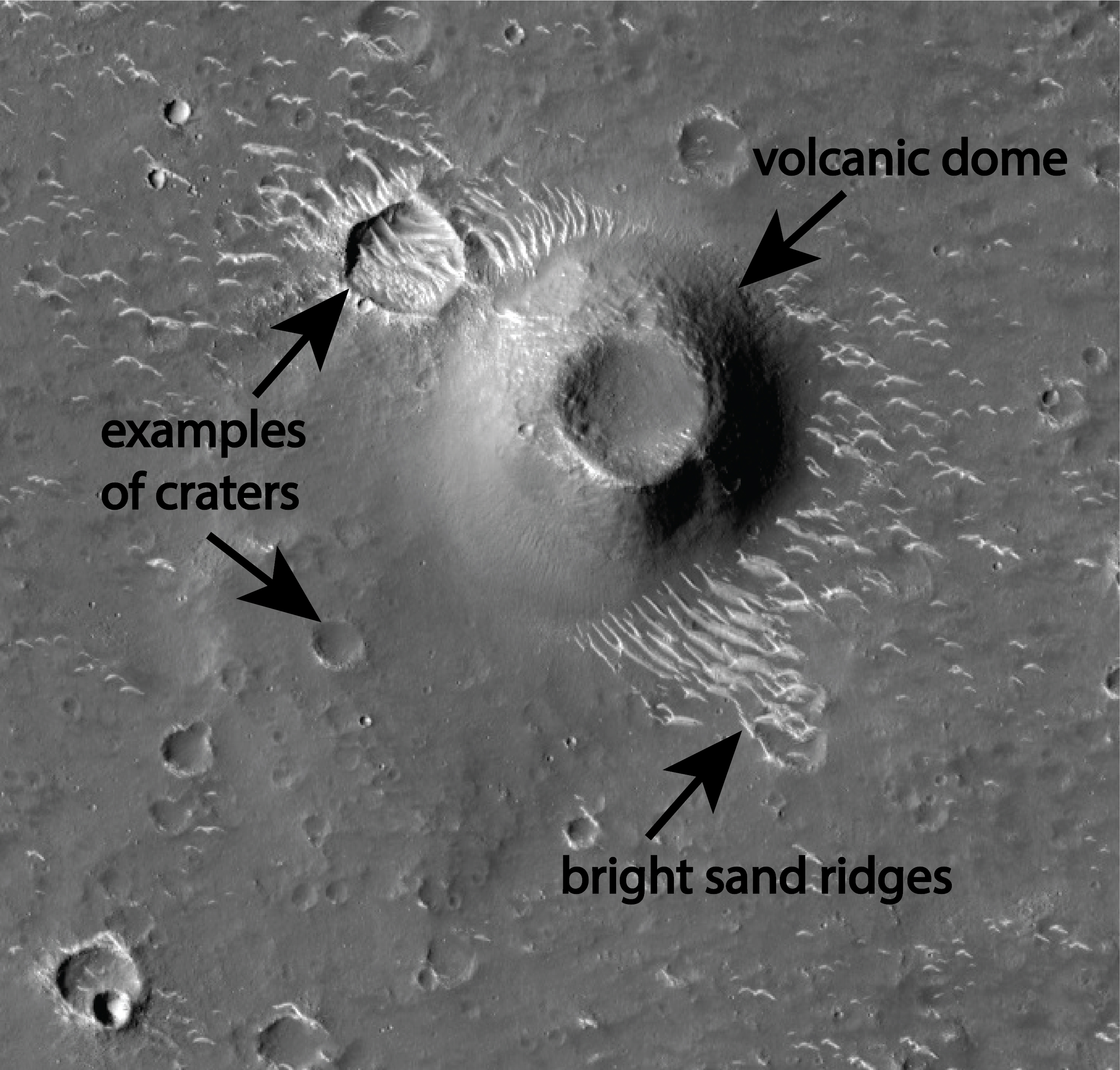
| 06:48, 23 September 2021 | ESP 070377 2050china.jpg (file) |  |
3.24 MB | Suitupandshowup | Features near China's lander, as seen by HiRISE The lander is called Zhurong and is in Utopia Planitia Source: HiRISE.lpl.arizona.edu/ESP_070377_2050 Image credit: NASA/JPL/University of Arizona | 1 |
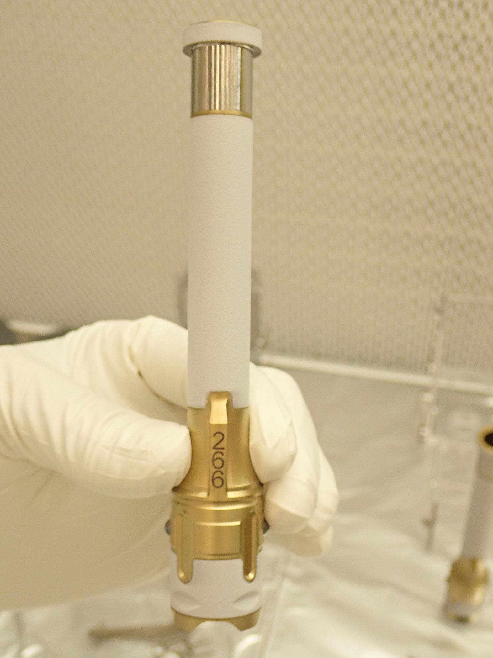
| 08:30, 21 September 2021 | Sampletube26218 PIA24808.jpg (file) |  |
251 KB | Suitupandshowup | Sample tube like the one used to gather the first sample from Mars. It was from a rock called “Rochette.” Source: https://mars.nasa.gov/news/9029/nasas-perseverance-rover-collects-first-mars-rock-sample/ Credits: NASA/JPL-Caltech | 1 |
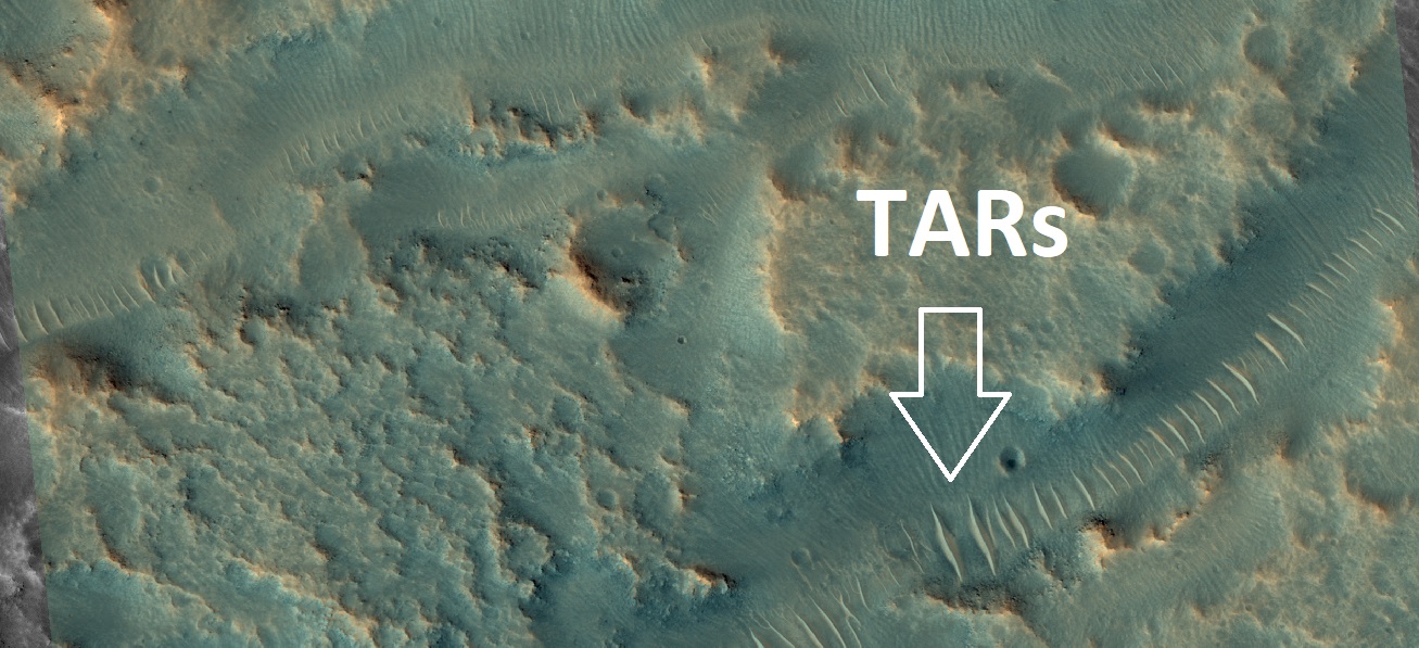
| 15:03, 20 September 2021 | 59515 2160tarswidearrows.jpg (file) |  |
294 KB | Suitupandshowup | TARs in low areas, as seen by HiRISE under HiWish program Arrows point to some of the TAR's. Source: HiRISE.lpl.arizona.edu/ESP_59515_2160 Image credit: NASA/JPL/University of Arizona | 1 |
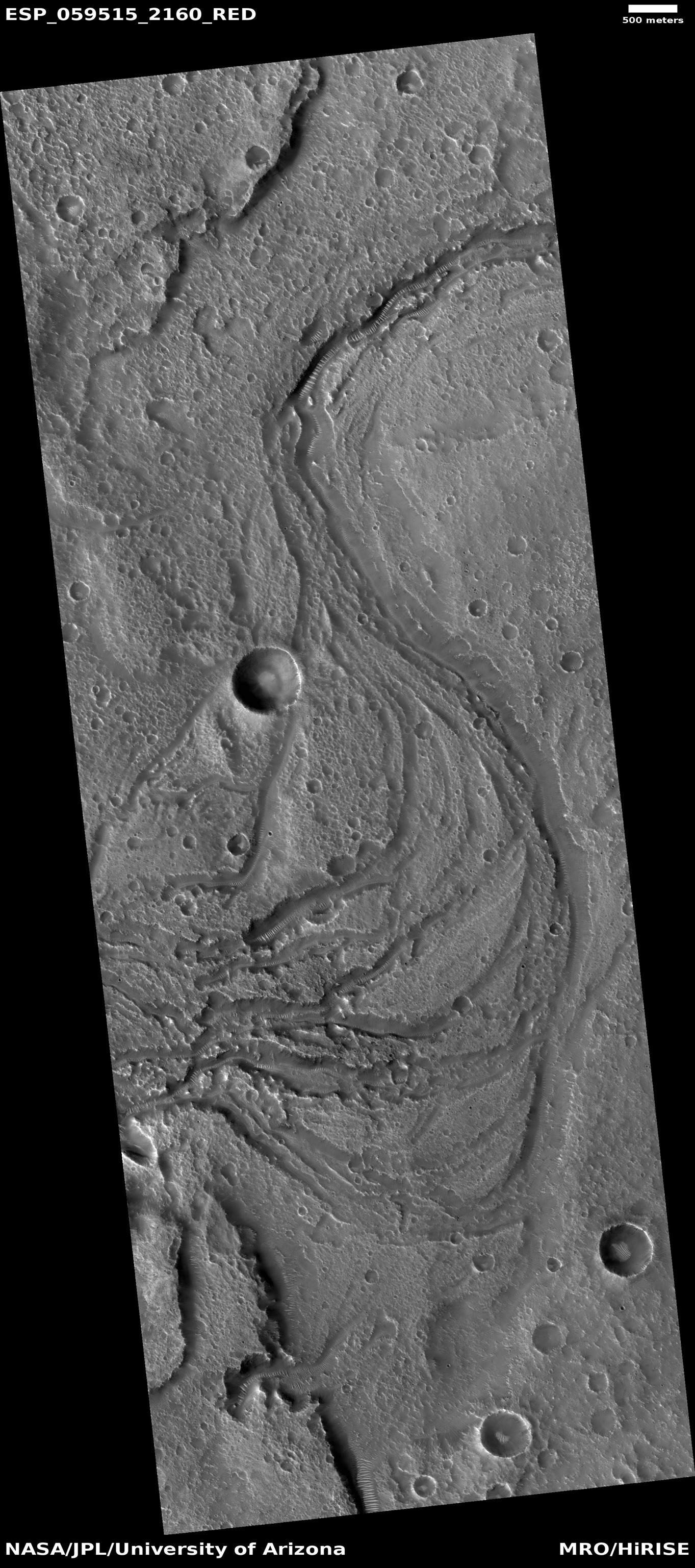
| 15:01, 20 September 2021 | 59515 2160tarslabeled.jpg (file) |  |
286 KB | Suitupandshowup | TARs in low areas, as seen by HiRISE under HiWish program Source: HiRISE.lpl.arizona.edu/ESP_59515_2160 Image credit: NASA/JPL/University of Arizona | 1 |
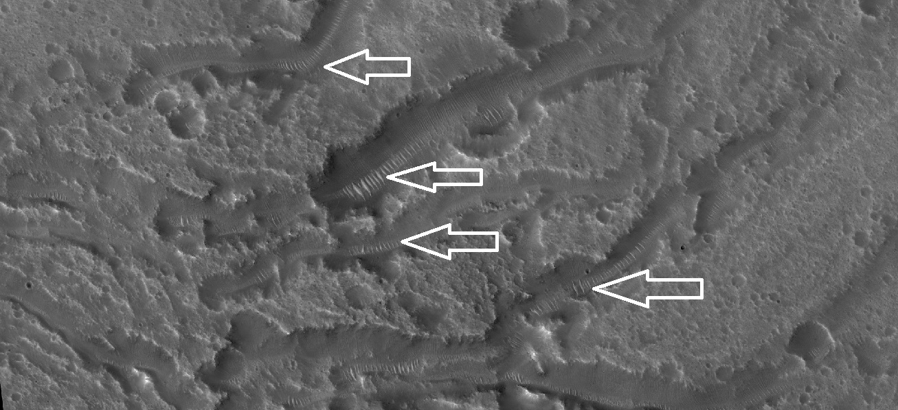
| 14:42, 20 September 2021 | Com59515 2160meander.jpg (file) |  |
923 KB | Suitupandshowup | Meander with TARs in low areas, as seen by HiRISE under HiWish program Source: HiRISE.lpl.arizona.edu/ESP_59515_2160 Image credit: NASA/JPL/University of Arizona | 1 |
| 09:20, 16 September 2021 | ESP 031138 1380dunes.jpg (file) |  |
1.58 MB | Suitupandshowup | Dunes, as seen by HiRISE under HiWish program Source: HiRISE.lpl.arizona.edu/ESP_031138_1380 Image credit: NASA/JPL/University of Arizona | 1 |
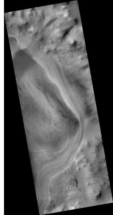
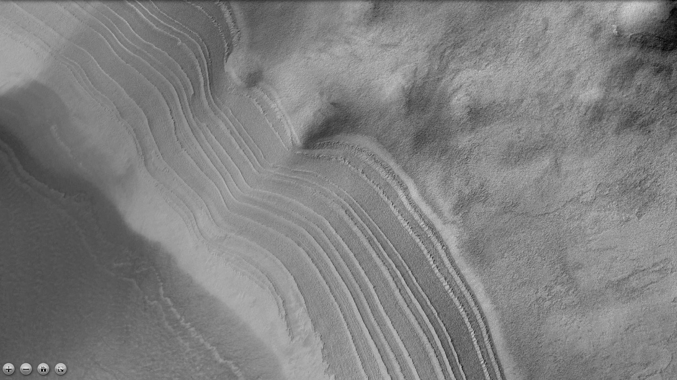
| 08:42, 15 September 2021 | 69629 2605npolarlayerswide.jpg (file) |  |
275 KB | Suitupandshowup | Layers in north polar ice cap, as seen by HiRISE under HiWish program. Source: HiRISE.lpl.arizona.edu/ESP_69629_2605 Credit: NASA/JPL/University of Arizona/Secosky | 1 |
| 08:20, 10 September 2021 | 70288 1960craterstreaks.jpg (file) |  |
426 KB | Suitupandshowup | Streaks in crater This type of arrangement of streaks is common in Martian craters. The scene is the Arabia quadrangle at 15.744 N and 21.271 E (Streaks in crater This type of arrangement of streaks is common in Martian craters. The scene is the Arabia quadrangle at 15.744 N and 21.271 E (ESP_070288_1960). There is much dust in the Arabia quadrangle so streaks are common there. Image credit: NASA/JPL/University of Arizona/Secosky.). There is much dust in the Arabia quadrangle so strea... | 1 |
| 15:02, 7 September 2021 | B17 016128 1596glaciersmarssocietywithglaciersjpg.jpg (file) |  |
318 KB | Suitupandshowup | Channels from past glaciers in a crater, called crater B. It is believed that past glaciers that were on the crater wall made channels and a lake. This crater represents another way that lakes can be created in craters. Source: http://viewer.mars.asu.edu/planetview/inst/ctx/B17_016128_1596_XI_20S317W#P=B17_016128_1596_XI_20S317W&T=2 Credit: NASA/MSSS | 1 |
| 14:58, 7 September 2021 | B17 016128 1596glaciersmarssociety.jpg (file) |  |
316 KB | Suitupandshowup | Channels from past glaciers in a crater, called crater B. It is believed that past glaciers that were on the crater wall made channels and a lake. This crater represents another way that lakes can be created in craters. Source: http://viewer.mars.asu.edu/planetview/inst/ctx/B17_016128_1596_XI_20S317W#P=B17_016128_1596_XI_20S317W&T=2 Credit: NASA/MSSS | 1 |
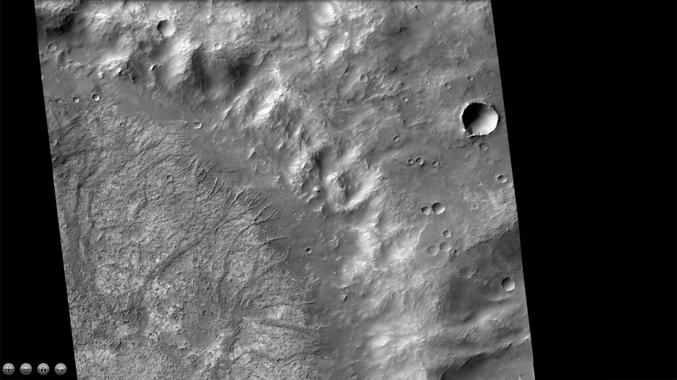
| 14:45, 7 September 2021 | J03 045825 2081sappingcraterdelta.jpg (file) |  |
114 KB | Suitupandshowup | CTX image of deltas that formed from ground water. This is evidence for an extensive ground water system on Mars. In some craters like these water came out of the ground and formed a lake in craters. Source: http://viewer.mars.asu.edu/planetview/inst/ctx/J05_046932_1903_XI_10N327W#P=J05_046932_1903_XI_10N327W,J03_045825_2081_XN_28N348W&T=3 Image Credit: NASA/MSSS | 1 |
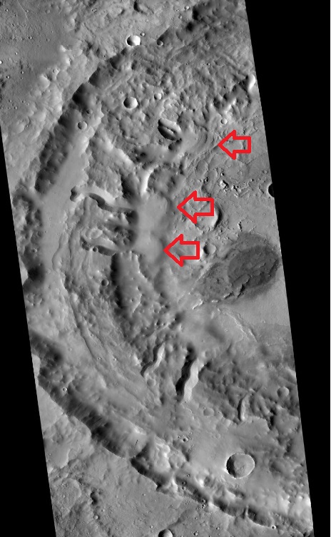
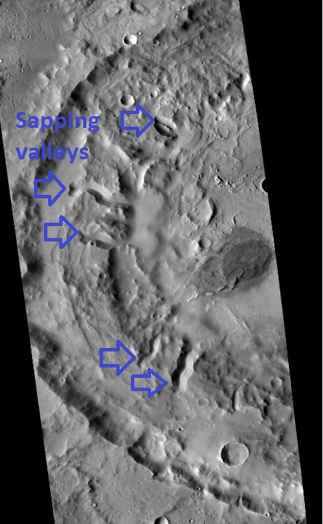
| 11:42, 5 September 2021 | J03 045825 2081sappingcraterarrowslabeled.jpg (file) |  |
118 KB | Suitupandshowup | CTX image of sapping valleys that formed from ground water. Image Credit: NASA/MSSS | 1 |
| 20:52, 20 August 2021 | Olympus2.jpg (file) |  |
238 KB | Michel Lamontagne | 1 | |
| 20:50, 20 August 2021 | Olympus.jpg (file) |  |
222 KB | Michel Lamontagne | 1 | |
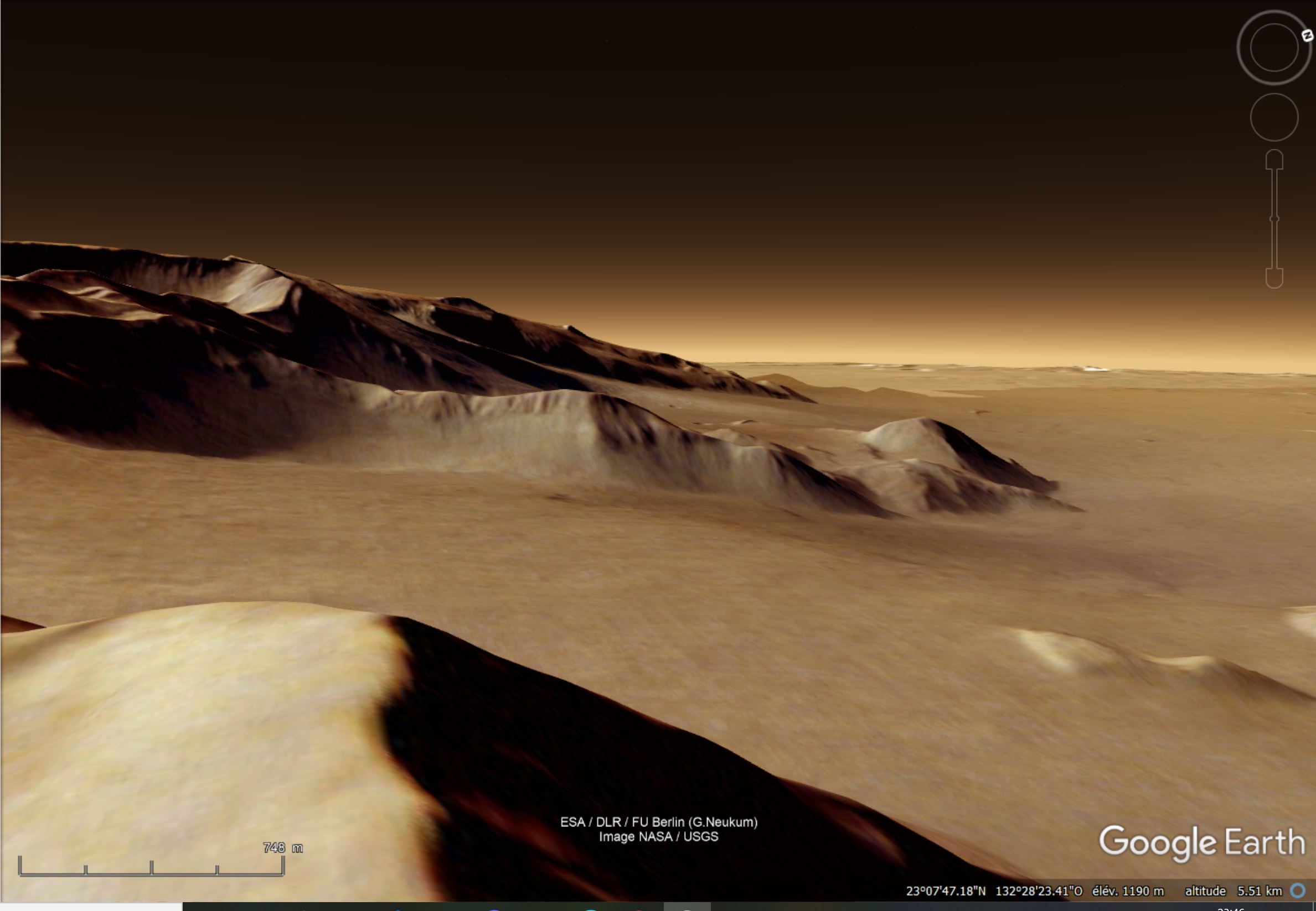
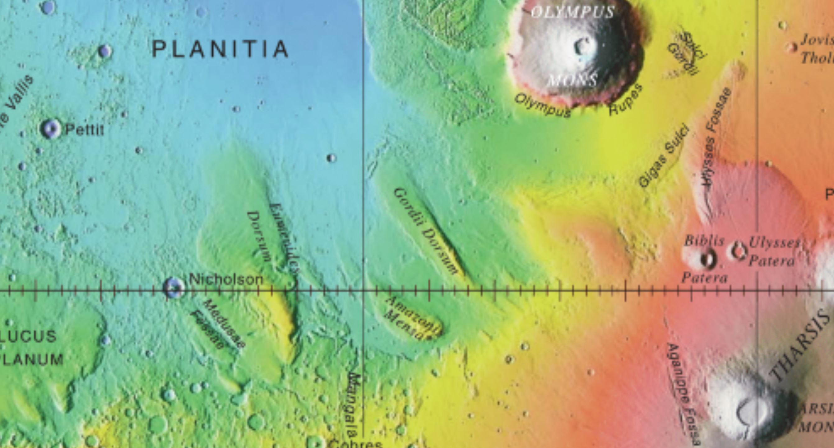
| 20:36, 20 August 2021 | Nicholson Google.jpg (file) |  |
322 KB | Michel Lamontagne | 1 | |
| 20:28, 20 August 2021 | Nicholson Crater.jpg (file) |  |
296 KB | Michel Lamontagne | 1 | |
| 06:05, 4 June 2021 | Shell2.png (file) |  |
292 KB | Michel Lamontagne | 1 | |
| 06:04, 4 June 2021 | Shell1.jpg (file) |  |
34 KB | Michel Lamontagne | 1 | |
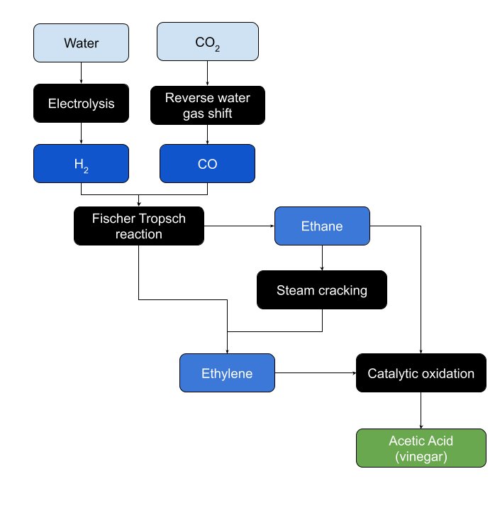
| 19:44, 25 May 2021 | Process-Acetic acid.png (file) |  |
36 KB | Michel Lamontagne | 1 | |
| 07:59, 15 May 2021 | 68460 1945lavechannel.jpg (file) |  |
247 KB | Suitupandshowup | Lave channel from Olympus Mons, as seen by HiRISE under HiWish program Source: Image Credit: | 1 |
| 07:56, 15 May 2021 | 68460 1945laveolympus.jpg (file) |  |
252 KB | Suitupandshowup | Lava flowing down a slope, as seen by HiRISE under HiWish program Lava is coming from Olympus Mons, the largest volcano in the solar system. Source: http://hirise.lpl.arizona.edu/ESP_068460_1945 Image Credit: NASA.JPL.University of Arizona | 1 |
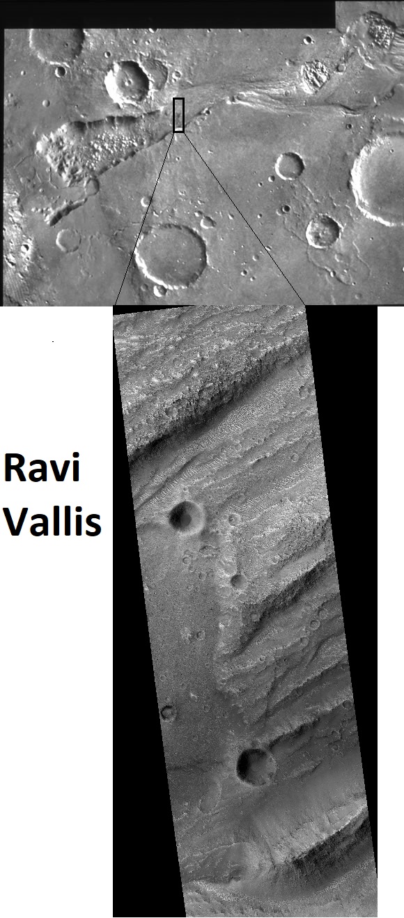
| 05:59, 13 May 2021 | 68206 1790ravicomposite.jpg (file) |  |
244 KB | Suitupandshowup | The Source Region of the Outflow Channel Ravi Vallis (1°S,42°W) This mosaic of the head of Ravi Vallis shows a 300-kilometer-long portion of the channel. Like many other channels that empty into the northern plains of Mars, Ravi Vallis originates in a region of collapsed and disrupted (“chaotic”) terrain within the planet's older, cratered highlands. Structures in these channels (slides #24 and #25) indicate that the channels were carved by liquid water moving at high flow rates. The abrupt... | 1 |


