File list
This special page shows all uploaded files.
| Date | Name | Thumbnail | Size | User | Description | Versions |
|---|---|---|---|---|---|---|
| 09:23, 1 June 2018 | Wide view of gully on hill.jpg (file) |  |
23 KB | Suitupandshowup | Wide, context view of gully on a hill Source: http://viewer.mars.asu.edu/planetview/inst/ctx/P06_003227_1345_XN_45S167W#start Image credit: NASA/MSSS | 1 |
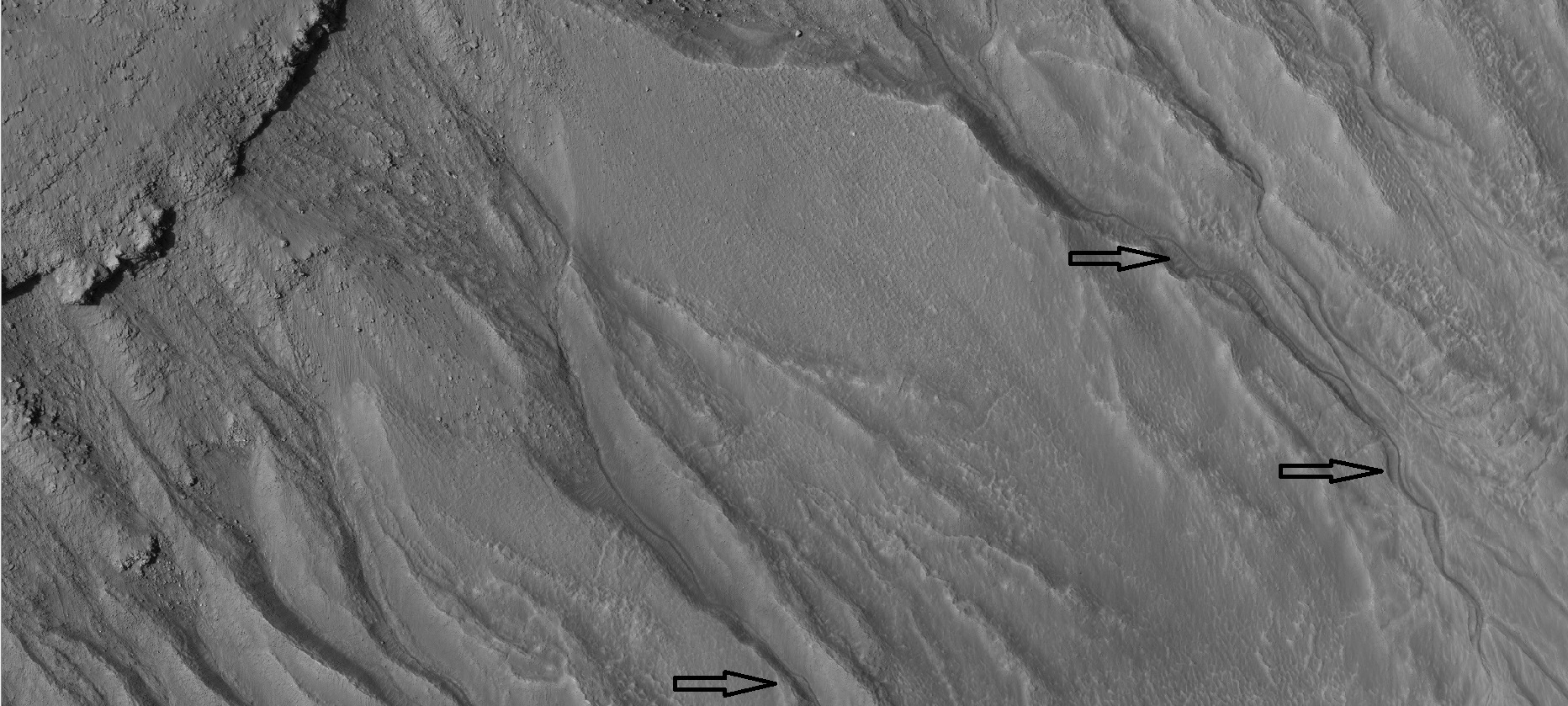
| 09:19, 1 June 2018 | ESP 039793 1385channeldetails.jpg (file) |  |
617 KB | Suitupandshowup | Gullies in crater with arrows showing channels within larger valleys, as seen by hirise under HiWish program Source: http://hirise.lpl.arizona.edu/ESP_039793_1385 Image credit: NASA/JPL/University of Arizona/Secosky | 1 |
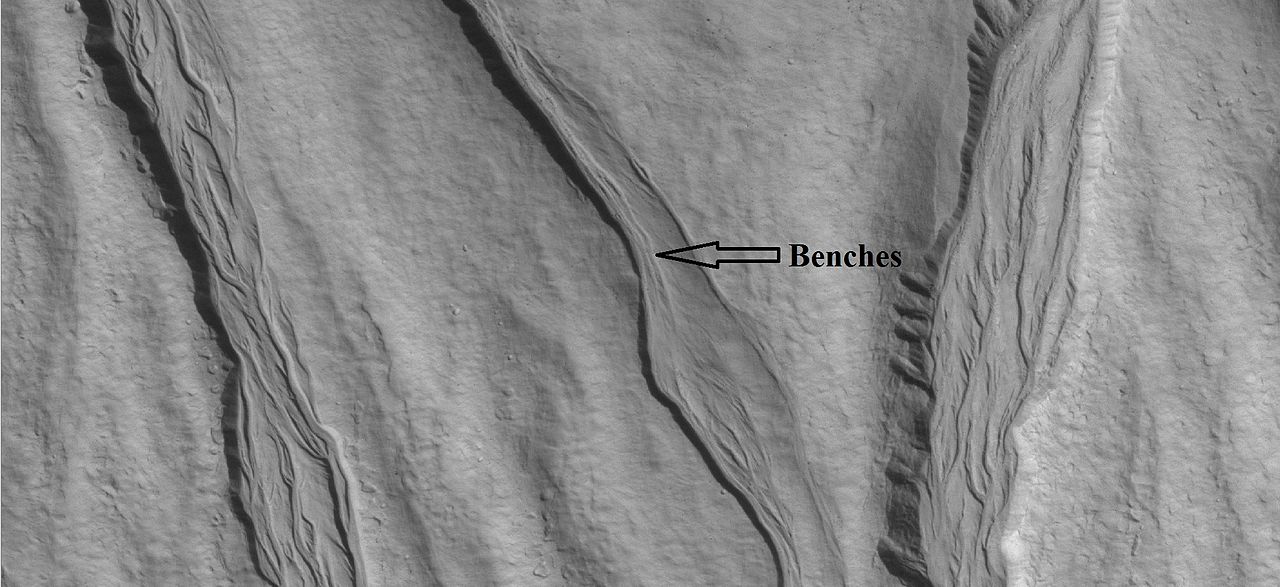
| 09:14, 1 June 2018 | ESP 037506 2285gullychannelsclose.jpg (file) |  |
131 KB | Suitupandshowup | Gully channel up close as seen by hirise under HiWish program Arrow points to benches in valley, so the level of water changed over time. Source: http://hirise.lpl.arizona.edu/ESP_037506_2285 Image credit: NASA/JPL/University of Arizona/Secosky | 1 |
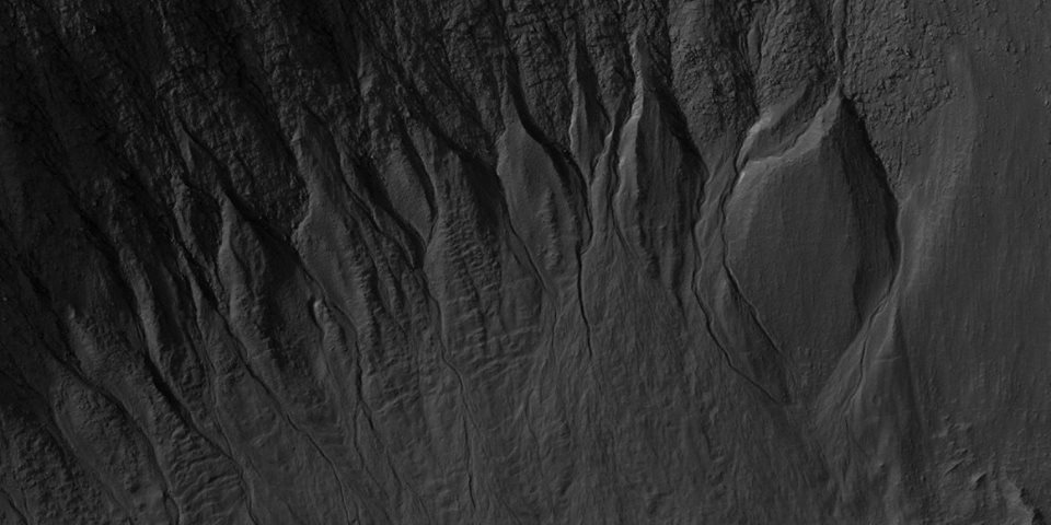
| 09:08, 1 June 2018 | 46386 1420gullies.jpg (file) |  |
74 KB | Suitupandshowup | Gullies, as seen by HiRISE under HiWish program The location is Phaethontis quadrangle at 37.608 S and 182.221 E (ESP_046386_1420). Source: http://hirise.lpl.arizona.edu/ESP_046386_1420 Image credit is NASA/JPL/University of Arizona. | 1 |
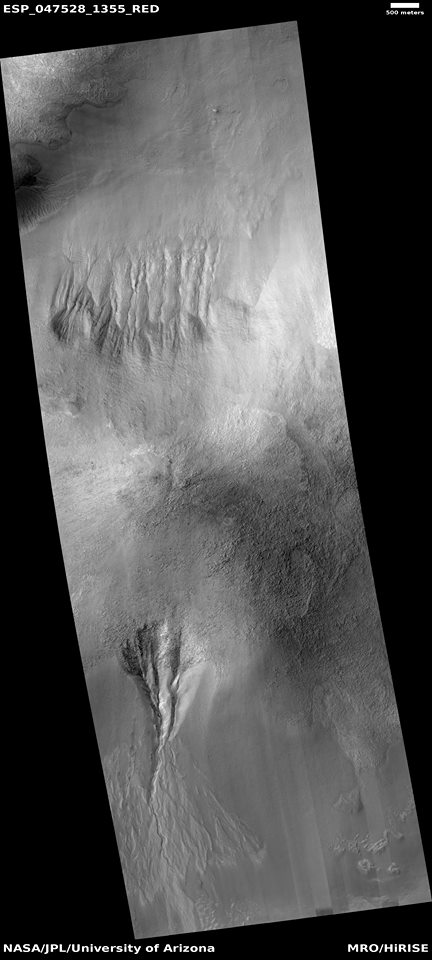
| 09:00, 1 June 2018 | 47528 1355gulliesmound.jpg (file) |  |
59 KB | Suitupandshowup | Gullies on 2 sides of a mound, as seen by HiRISE under HiWish program The location is Nereidum Montes in the Argyre quadrangle at 44.178 S and 326.195 E (ESP_047528_1355). Source: http://hirise.lpl.arizona.edu/ESP_047528_1355 Image credit is NASA/... | 1 |
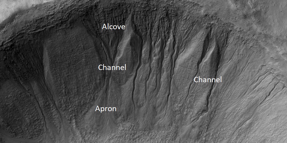
| 08:41, 1 June 2018 | 50858 1435gullies.jpg (file) |  |
153 KB | Suitupandshowup | Gullies with alcove, channels, and apron labeled, as seen by HiRISE under HiWish program The location is 36.353 S and 125.289 E (ESP_050858_1435). Source: http://hirise.lpl.arizona.edu/ESP_050858_1435 Image credit is NASA/JPL/University of Arizona. | 1 |
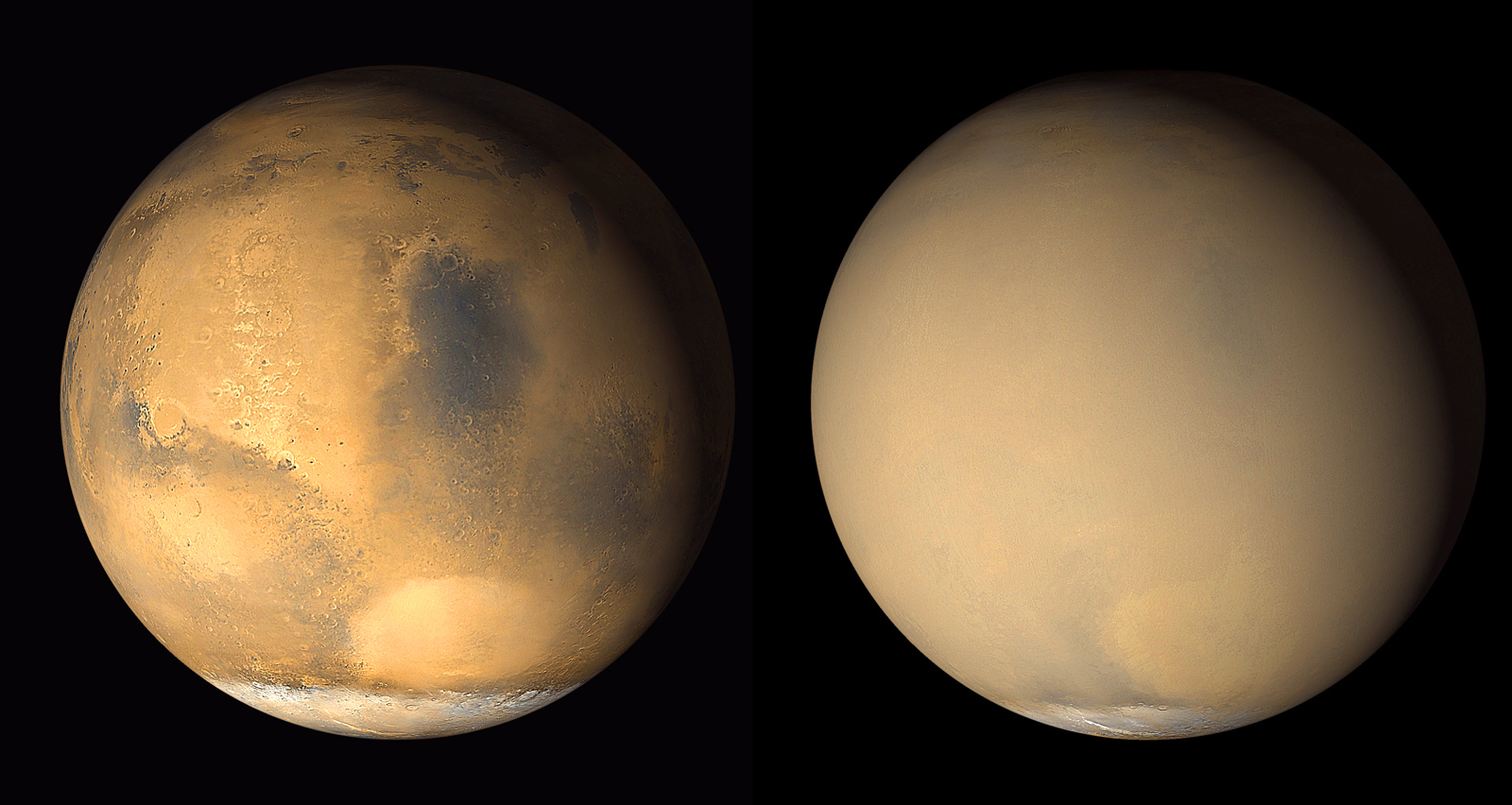
| 11:34, 29 May 2018 | PIA03170 fig1duststroms.jpg (file) |  |
959 KB | Suitupandshowup | Mars without a dust storm on June 2001 (on left) and with a dust storm on July 2001 (on right), as seen by Mars Global Surveyor. Source: https://photojournal.jpl.nasa.gov/figures/PIA03170_fig1.jpg Image credit: NASA/JPL/MSSS | 1 |
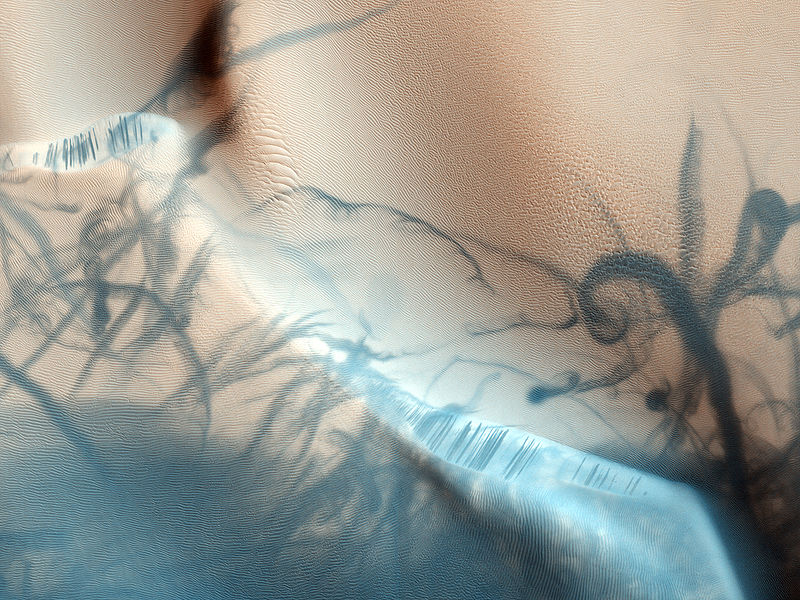
| 18:11, 28 May 2018 | WikidanielsonPSP 002522 1880devil.jpg (file) |  |
50 KB | Suitupandshowup | Dust devil tracks and layers in Danielson Crater in the Arabia quadrangle, as seen by HiRISE under HiWish program Source: http://hirise.lpl.arizona.edu/PSP_002522_1880 Image Credit: NASA/JPL/University of Arizona/Secosky | 1 |
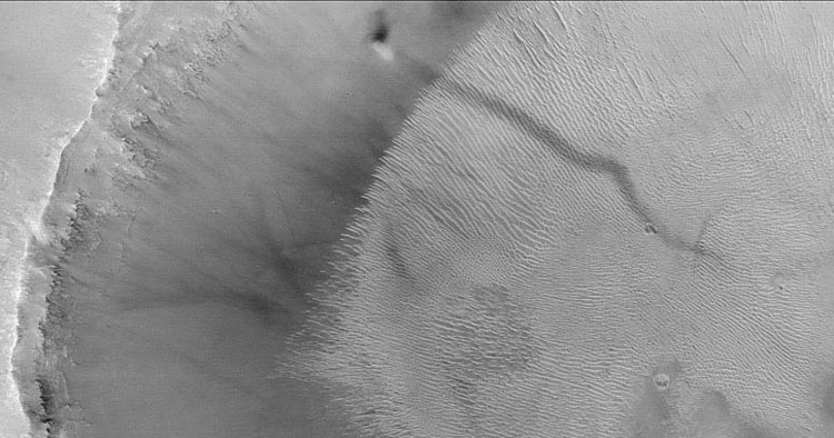
| 18:09, 28 May 2018 | ESP 036631 2335devilsbottom.jpg (file) |  |
60 KB | Suitupandshowup | Dust devil tracks, as seen by hirise under HiWish program Location is Casius quadrangle. Source: http://hirise.lpl.arizona.edu/ESP_036631_2335 Image credit: NASA?JPL/University of Arizona/Secosky | 1 |
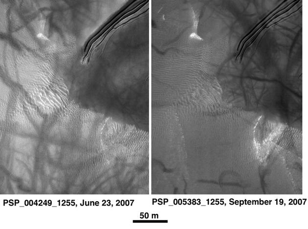
| 18:06, 28 May 2018 | Russel Crater Dust Devil Changes.jpg (file) |  |
43 KB | Suitupandshowup | Russel Crater Dust Devil Changes, as seen by hirise. Location is 54.3 degrees south latitude and 13 degrees east longitude. Image was taken by the Mars Reconnaissance Orbiter's HiRISE. The HiRISE camera was built by Ball Aerospace and Technology Corpor... | 1 |
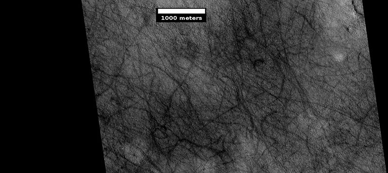
| 17:58, 28 May 2018 | Martian Dust Devil Trails.jpg (file) |  |
147 KB | Suitupandshowup | This portion of a recent high-resolution picture from the HiRISE camera on board the Mars Reconnaissance Orbiter shows twisting dark trails criss-crossing light coloured terrain on the Martian surface. Newly formed trails like these had presented resea... | 1 |
| 17:54, 28 May 2018 | Dust.devil.mars.arp.750pix.jpg (file) |  |
76 KB | Suitupandshowup | A dust devil on Mars, photographed by Mars Global Surveyor. The long dark streak is formed by a moving swirling column of Martian atmosphere. The dust devil itself (the black spot) is climbing the crater wall. The streaks on the right are sand dunes on... | 1 |
| 06:44, 25 May 2018 | 53630 2195brainslvf.jpg (file) |  |
241 KB | Suitupandshowup | Brain terrain The wide ridges probably still contain a core of ice. The location is the Ismenius Lacus quadrangle at 39.374 N and 34.883 E (ESP_053630_2195). Image credit is NASA/JPL/University of Arizona. | 1 |
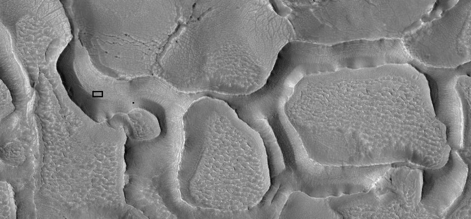
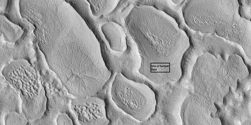
| 06:36, 25 May 2018 | 54527 2225brainsface.jpg (file) |  |
335 KB | Suitupandshowup | Brain terrain to the right with box showing size of football field. Picture taken with HiRISE under HiWish program. Source: http://hirise.lpl.arizona.edu/54527_2225 Image credit: NASA/JPL/University of Arizona/Secosky | 1 |
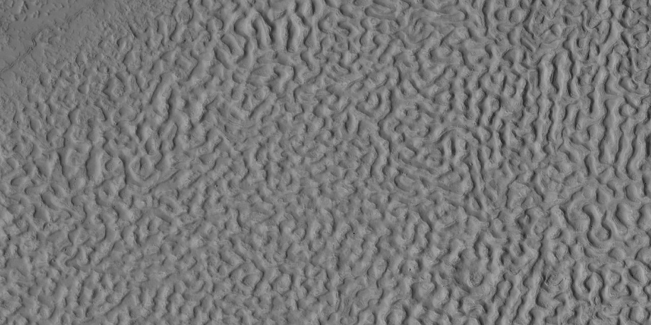
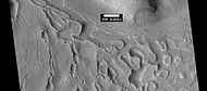
| 06:56, 23 May 2018 | 45507 2200brains.jpg (file) |  |
136 KB | Suitupandshowup | Brain terrain, as seen by hirise under HiWish program Source: http://hirise.lpl.arizona.edu/ESP_045507_2200 Image credit: NASA/JPL/University of Arizona | 1 |
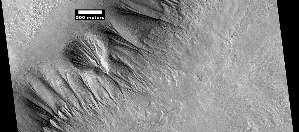
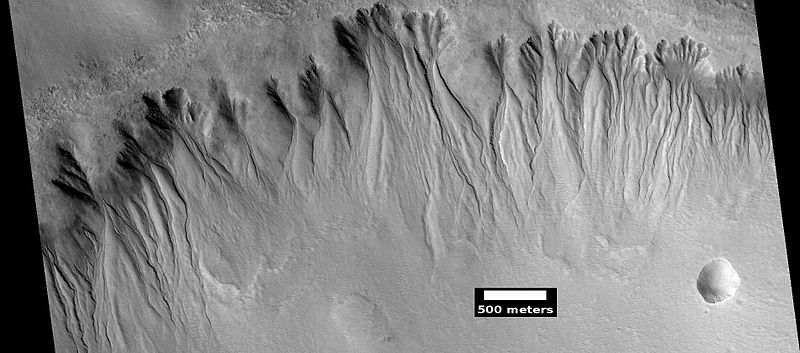
| 06:46, 23 May 2018 | ESP 044707 2285gullies.jpg (file) |  |
126 KB | Suitupandshowup | Gullies, as seen by hirise under HiWish program, location Arcadia quadrangle, along mesa wall Source: http://hirise.lpl.arizona.edu/ESP_044707_2285 Image credit: NASA/JPL/ University of Arizona/Secosky | 1 |
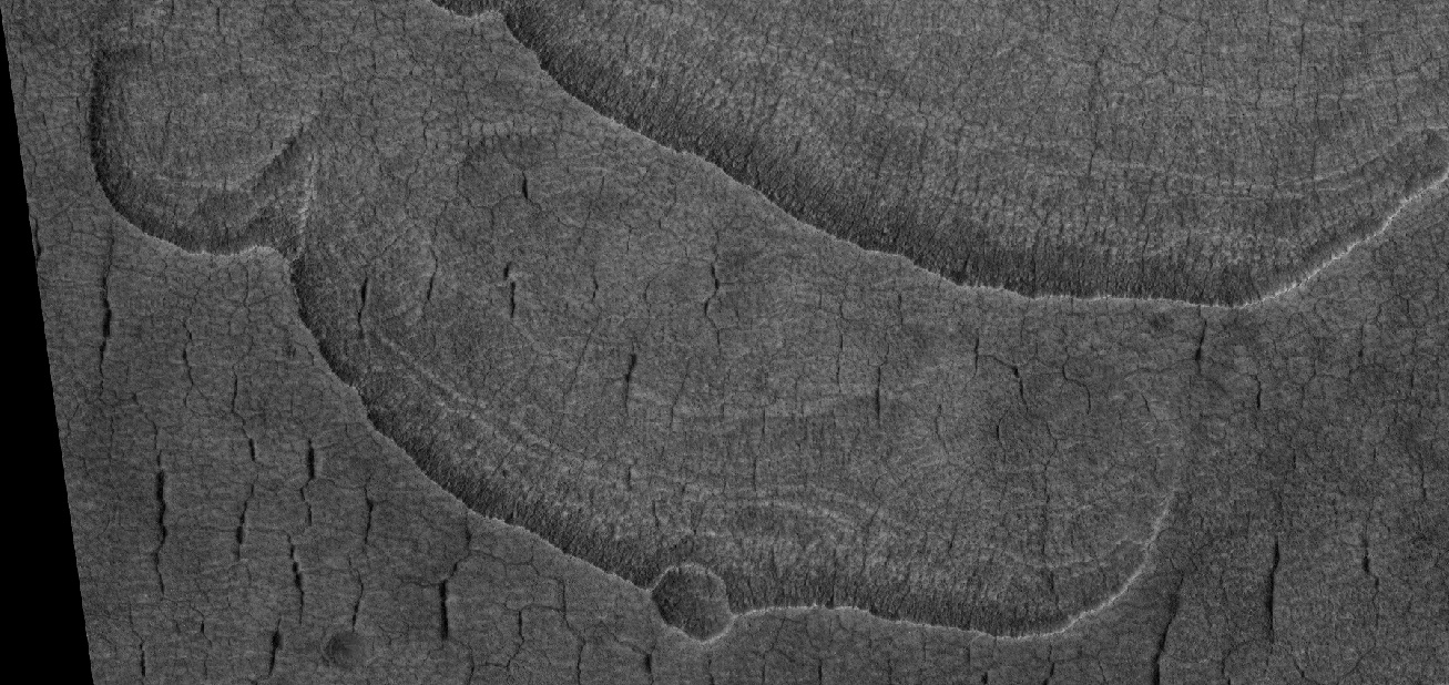
| 05:41, 23 May 2018 | 53496 2245scallopsclose.jpg (file) |  |
391 KB | Suitupandshowup | Close view of scalloped terrain The location is the Casius quadrangle at 44.333 N and 91.382 E (ESP_053496_2245). Image credit is NASA/JPL/University of Arizona. Source: http://hirise.lpl.arizona.edu/53496_2245 | 1 |
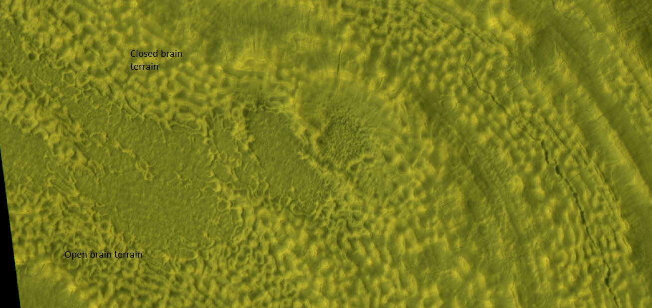
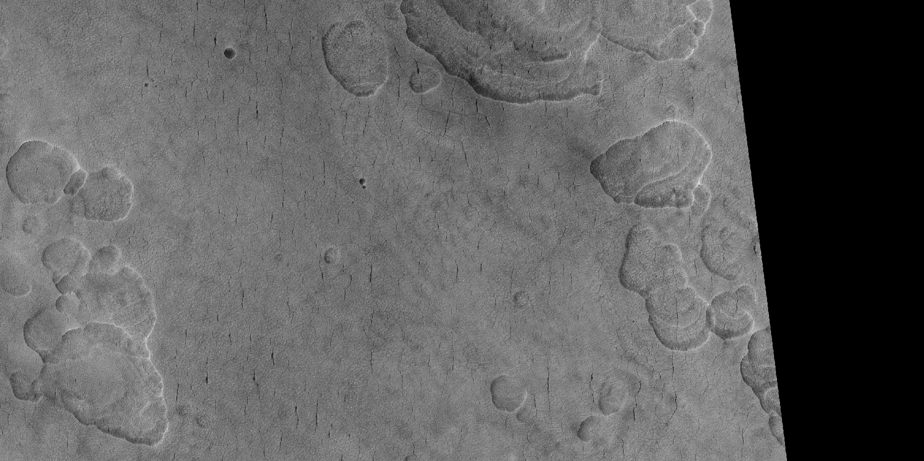
| 15:32, 18 May 2018 | 53642 2225brains.jpg (file) |  |
251 KB | Suitupandshowup | Open and closed brain terrain labeled, as seen by HiRISE under HiWish program Source: hirise.lpl.arizona.edu/ESP_53642_2225 Image credit: NASA/JPL/University of Arizona/Secosky | 1 |
| 13:25, 18 May 2018 | 44042 2240scallopedterrain.jpg (file) |  |
734 KB | Suitupandshowup | Scalloped terrain, as seen by HiRISE under HiWish program Location is Casius quadrangle Source: http://hirise.lpl.arizona.edu/ESP_44042_2240 Image credit: NASA/JPL/ University of Arizona | 1 |
| 13:08, 18 May 2018 | 58846 4712092039657 1751888588 nhallowsfootball.jpg (file) |  |
104 KB | Suitupandshowup | Hollowed terrain, as seen by HiRISE under HiWish program Box shows the size of a football field. The location is 44.6 N and 28.2 E (ESP_028207_2250). Image credit is NASA/JPL/University of Arizona. | 1 |
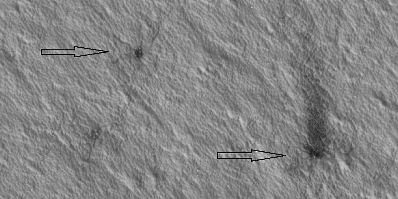
| 12:51, 18 May 2018 | 47609 0985spiderlongclose.jpg (file) |  |
130 KB | Suitupandshowup | Plumes and spiders in Mare Australe quadrangle, as seen by HiRISE under HiWish program Source: http:hirise.lpl.arizona.edu/ESP_047609_0985 Image credit: NASA/JPL/University of Arizona/Secosky | 1 |
| 12:41, 18 May 2018 | ESP 037506 2285gullychannels.jpg (file) |  |
62 KB | Suitupandshowup | Gullies in Mare Acidalium quadrangle as seen by hirise under HiWish program Source: http://hirise.lpl.arizona.edu/ESP_037506_2285 Image Credit: NASA/JPL/University of Arizona/Secosky | 1 |
| 11:46, 18 May 2018 | 46325 2225hollowsclose2.jpg (file) |  |
85 KB | Suitupandshowup | Hollows formed in ribbed terrain in the Ismenius Lacus quadrangle, as seen by HiRISE under HiWish program Source: http://hirise.lpl.arizona.edu/ESP_046325_2225 Image Credit: NASA/JPL/University of Arizona/Jim Secosky | 1 |
| 11:37, 18 May 2018 | ESP 042554 2245ribbedterrain.jpg (file) |  |
5 KB | Suitupandshowup | Ribbed terain developing, as seen by hirise under HiWish program Location is 44.029 N and 25.53 E Source: http://hirise.lpl.arizona.edu/ESP_042554_2245 Image courtesy NASA/JPL/University of Arizona | 1 |
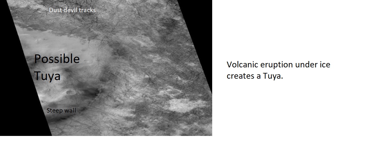
| 07:56, 7 May 2018 | Volcanounderice.jpg (file) |  |
124 KB | Suitupandshowup | Labeled picture of a possible Tuya (volcano that erupted under ice), as seen by CTX Author: Jim Secosky modified CTX image Image credit:NASA/MSSS/Secosky Source: http://viewer.mars.asu.edu/planetview/inst/ctx/J11_049043_1156_XN_64S355W#P=J11_049043_1... | 1 |
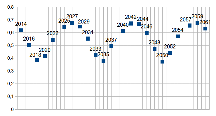
| 06:17, 1 May 2018 | Mars oppositions 2012-2061.png (file) |  |
21 KB | Denis nyrkov | Mars oppositions from 2012 to 2061 year | 1 |
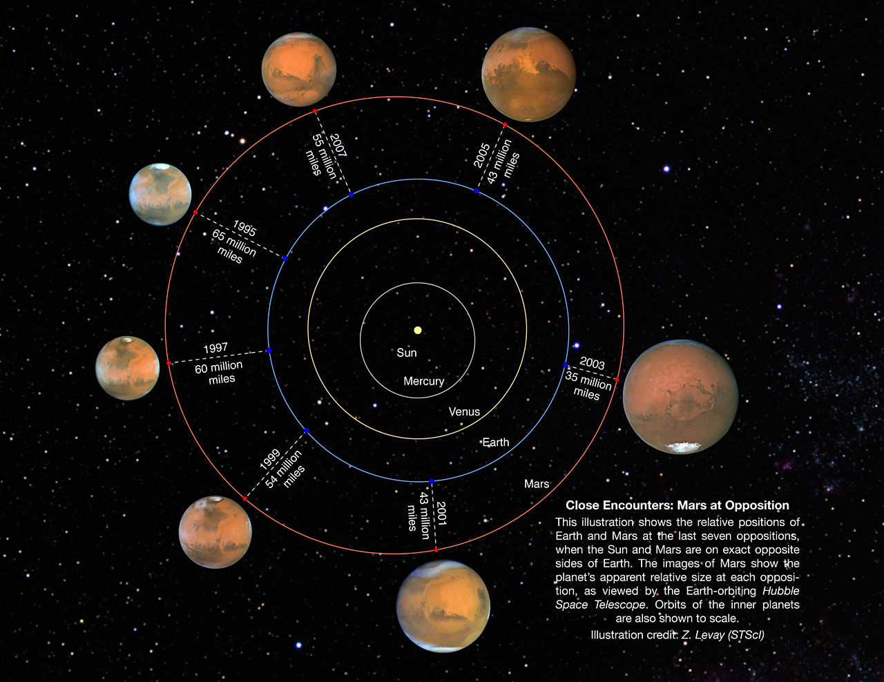
| 23:36, 30 April 2018 | Mars oppositions.jpg (file) |  |
195 KB | Denis nyrkov | Mars Oppositions from 1995 to 2007 year | 1 |
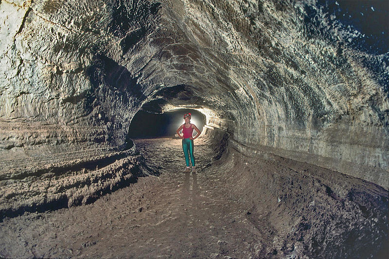
| 06:19, 28 April 2018 | Valentine Cave.JPG (file) |  |
185 KB | Suitupandshowup | Valentine Cave, a lava tube at Lava Beds National Monument, California, USA Source: Dave Bunnell / Under Earth Images https://commons.wikimedia.org/wiki/File:Valentine_Cave.JPG | 1 |
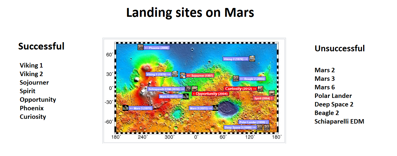
| 12:13, 27 April 2018 | Marspedialanders.png (file) |  |
435 KB | Suitupandshowup | Topographic map showing landing site of successful and unsuccessful missions Image credit: NASA/USGS/USGS Astrogeology Center/Secosky | 1 |
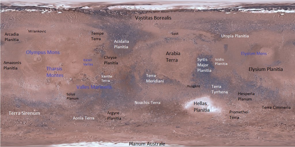
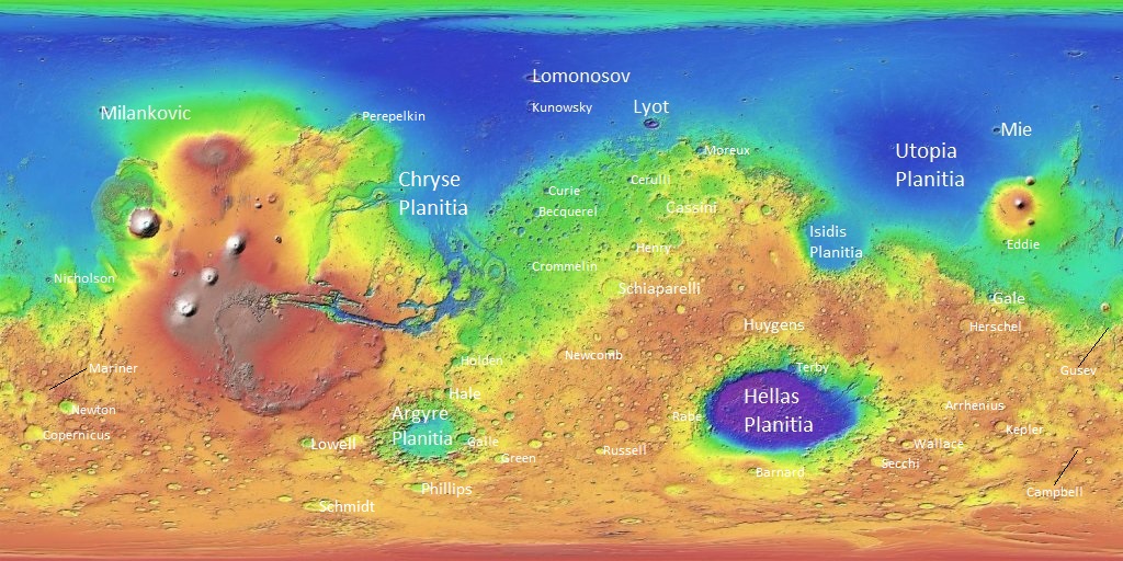
| 11:53, 27 April 2018 | Mars Viking MDIM21 ClrMosaic global 1024labeled5.jpg (file) |  |
195 KB | Suitupandshowup | Labeled map of major features/regions using Mariner 9 and Viking images Image credit: NASA/NAS AMES/USGS Astrogelolgy Center/Secosky Source: https://astrogeology.usgs.gov/search/map/Mars/Viking/MDIM21/Mars_Viking_MDIM21_ClrMosaic_global_232m | 1 |
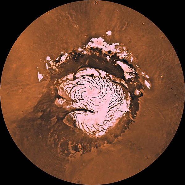
| 16:05, 26 April 2018 | Mars NPArea-PIA00161.jpg (file) |  |
84 KB | Suitupandshowup | North pole region showing ice cap with spiral-patterned troughs that expose layered terrrain Source: http://photojournal.jpl.nasa.gov/catalog/PIA00161 Image credit: NASA/JPL/USGS | 1 |
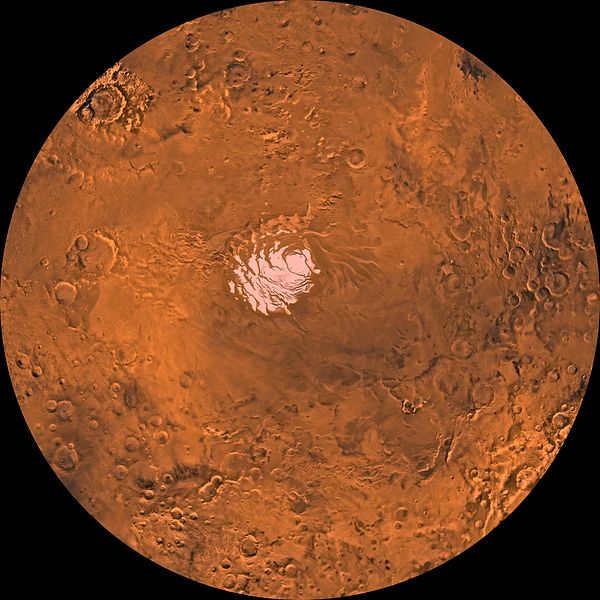
| 15:41, 26 April 2018 | PIA00190-MC-30-MareAustraleRegion-19980605.jpg (file) |  |
72 KB | Suitupandshowup | Mare Australe Region showing southern ice cap Source: http://photojournal.jpl.nasa.gov/jpeg/PIA00190.jpg Image credit: NASA/JPL/USGS | 1 |
| 12:13, 26 April 2018 | Mars MGS colorhillshade mola 1024craters2.jpg (file) |  |
221 KB | Suitupandshowup | Topographic map with Martian craters labeled Feel free to use this. I labeled the craters onto a map that was public domain, and I give my permission to use this map. Source: https://planetarynames.wr.usgs.gov/ Image Credit: NASA/USGS/USGS Astrogeo... | 1 |
| 08:10, 26 April 2018 | MGS MOC Wide Angle Map of Mars PIA03467.jpg (file) |  |
55 KB | Suitupandshowup | MGS MOC Wide Angle Map of Mars In 1979, NASA published ATLAS OF MARS: THE 1:5,000,000 MAP SERIES, edited by R.M. Batson, P.M. Bridges, and J.L. Inge, of the U.S. Geological Survey in Flagstaff, Arizona. This was a compendium of airbrushed shaded reli... | 1 |
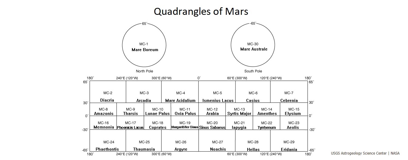
| 07:59, 26 April 2018 | Marspediaquadrangleoutline.jpg (file) |  |
101 KB | Suitupandshowup | Outline showing names and locations of quadrangles on Mars Source: https://planetarynames.wr.usgs.gov/Page/mars1to5mTHEMIS Picture credit: NASA/USGS Astrogeology Science Center | 1 |
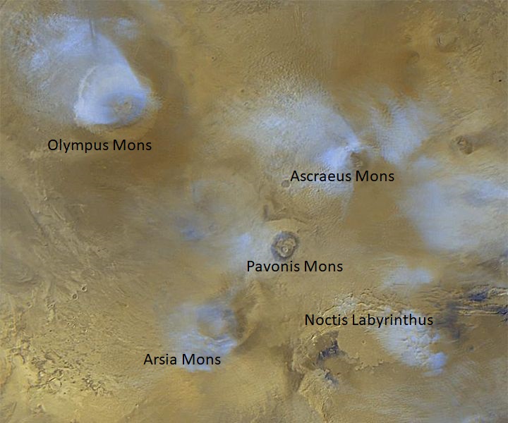
| 08:06, 25 April 2018 | Tharsis-PIA02049clouds.jpg (file) |  |
107 KB | Suitupandshowup | The volcanoes of the Tharsis region are highlighted by this color image mosaic obtained on a single martian afternoon by the Mars Orbiter Camera (MOC) onboard the Mars Global Surveyor (MGS) spacecraft. Olympus Mons dominates the upper left corner -- it... | 1 |
| 08:02, 25 April 2018 | Tharsis mons Viking.jpg (file) |  |
86 KB | Suitupandshowup | Viking 1 picture with features labeled of Tharsis Montes Source: NASA Image Credit: NASA/Secosky | 1 |
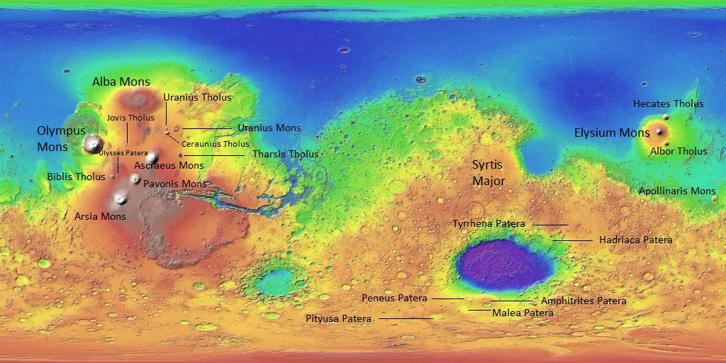
| 07:45, 25 April 2018 | Mars MGS colorhillshade mola 1024volcanoessyrtis.jpg (file) |  |
225 KB | Suitupandshowup | Topographic map with Martian volcanoes labeled including Tharsis volcanoes to the left Feel free to use this. I labeled the volcanoes and give my permission to use this map. Source: https://planetarynames.wr.usgs.gov/ Image Credit: NASA/USGS/USGS A... | 1 |
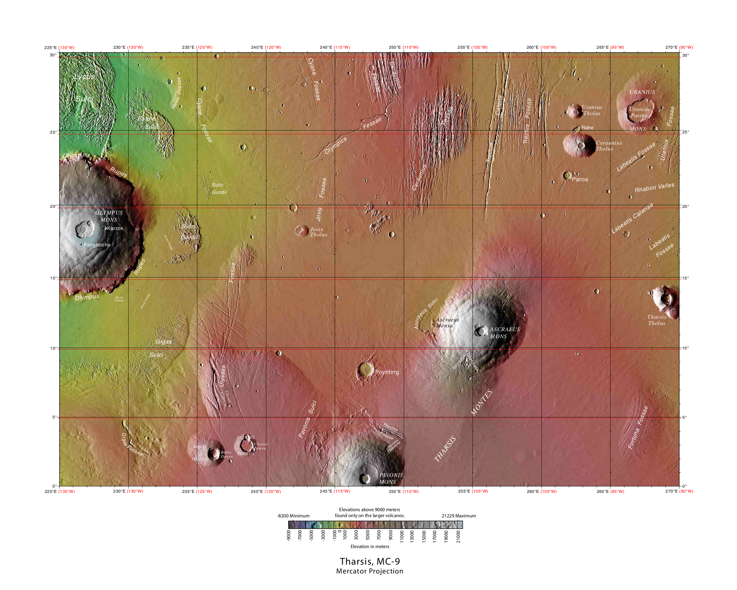
| 07:35, 25 April 2018 | USGS-Mars-MC-9-TharsisRegion-mola.png (file) |  |
4.51 MB | Suitupandshowup | Topographic map of Tharsis quadrangle showing many of the volcanoes of Tharsis Source: https://planetarynames.wr.usgs.gov/Page/Images Image credit: NASA/USGS/USGS Astrogeology Center | 1 |
| 08:46, 14 April 2018 | PIA22240slopstreaks.jpg (file) |  |
140 KB | Suitupandshowup | Slope streaks, as seen by HiRISE Source: https://photojournal.jpl.nasa.gov/catalog/PIA22240 https://hirise.lpl.arizona.edu/ESP_053518_1955 Image credit: NASA/JPL/University of Arizona | 1 |
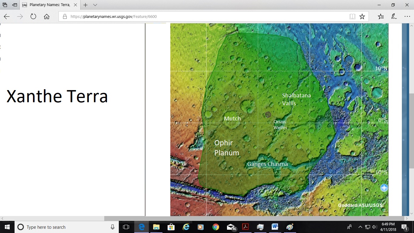
| 18:15, 12 April 2018 | Xantheterra6.jpg (file) |  |
310 KB | Suitupandshowup | Map of Xanthe Terra with some parts labeled Source: https://planetarynames.wr.usgs.gov/Feature/6600;jsessionid=9863D06D27E9EAF7A14084DCDEB35AC1 Picture credit: NASA/USGS/Secosky | 1 |
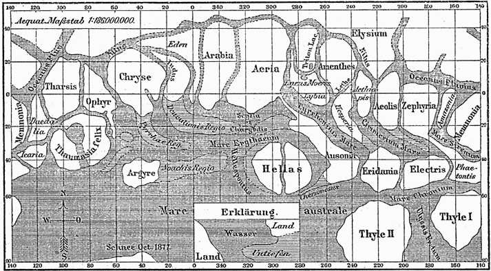
| 15:19, 12 April 2018 | Karte Mars Schiaparelli MKL1888.png (file) |  |
86 KB | Suitupandshowup | Historical map of planet Mars from Giovanni Schiaparelli Source: Meyers Konversations-Lexikon (German encyclopaedia), 1888. This image comes from the 4th edition of Meyers Konversationslexikon (1885–90). The copyrights have expired and this image... | 1 |
| 15:04, 12 April 2018 | Mars m04 11emarinercraterfrom mariner4.jpg (file) |  |
115 KB | Suitupandshowup | Photo of Mariner crater on Mars taken by Mariner 4 Source: http://www.jpl.nasa.gov/history/60s/Mariner4_1965.htm [1] Permission: PD NASA | 1 |
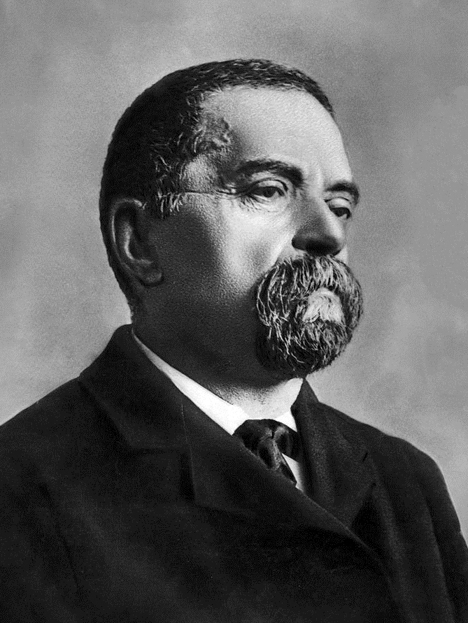
| 14:57, 12 April 2018 | Giovanni Schiaparelli 1890s.jpg (file) |  |
365 KB | Suitupandshowup | Giovanni Schiaparelli who named many of the regions of Mars This image is in the public domain because its copyright has expired and its author is anonymous. | 1 |
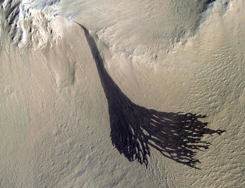
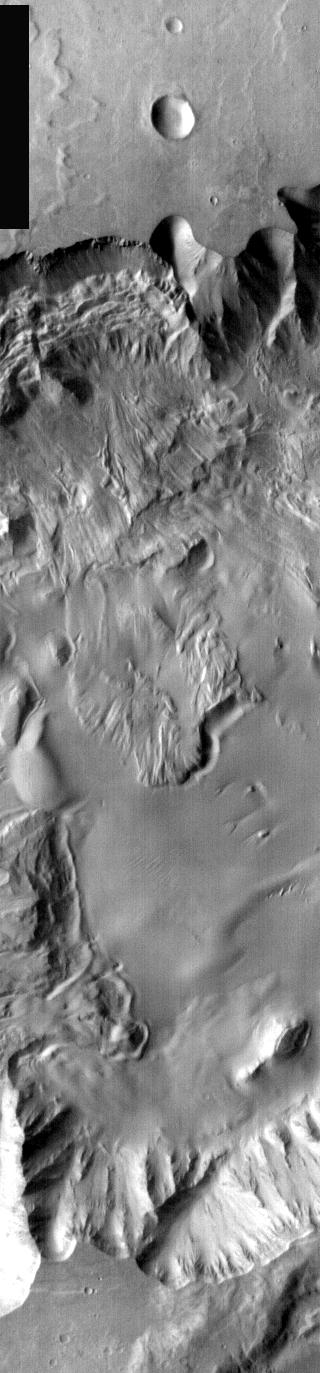
| 12:10, 12 April 2018 | Chaos in Xanthe.jpg (file) |  |
69 KB | Suitupandshowup | This is a daytime THEMIS IR image of a chaos region within Xanthe Terra, showing a landslide. Source: http://photojournal.jpl.nasa.gov/catalog/PIA07204 Image credit: NASA/JPL/Arizona State University | 1 |
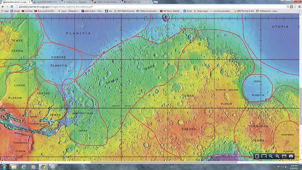
| 12:06, 12 April 2018 | Wikiarabiaboundaries.jpg (file) |  |
199 KB | Suitupandshowup | MOLA map showing boundaries of Xanthe Terra, Arabia, and nearby regions Source: http://planetarynames.wr.usgs.gov/images/mola_regional_boundaries.pdf Image Credit: NASA/USGS | 1 |
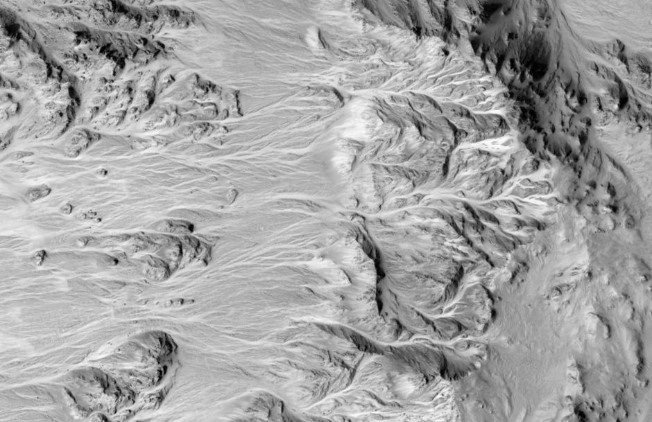
| 11:24, 12 April 2018 | Alluvial Fans in Mojave Crater.jpg (file) |  |
102 KB | Suitupandshowup | Alluvial fans in Mojave Crater of Mars, as seen by Hirise. Location is 7.6 N and 327.4 E. Source: http://hirise.lpl.arizona.edu/PSP_001415_1875 Image credit: NASA/JPL/University of Arizona | 1 |
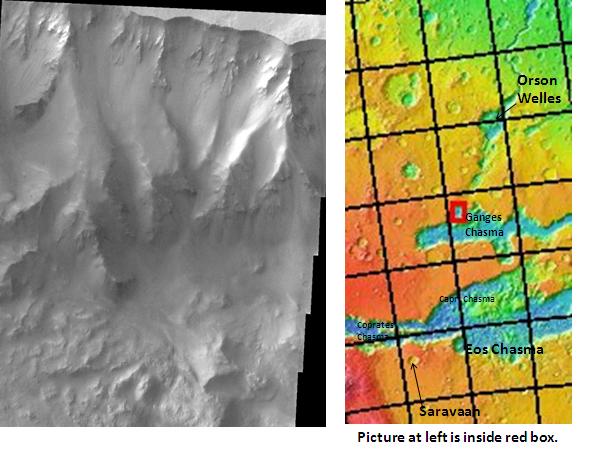
| 08:12, 11 April 2018 | Ganges Chasma.jpg (file) |  |
48 KB | Suitupandshowup | Ganges Chasma, as seen by THEMIS. The location is 6.4 degrees south latitude and 310.7 degrees east longitude. Image is about 18 km wide. Date Source: http://themis.asu.edu/zoom-20050413a Image credit: NASA/JPL/ASU/Secosky | 1 |
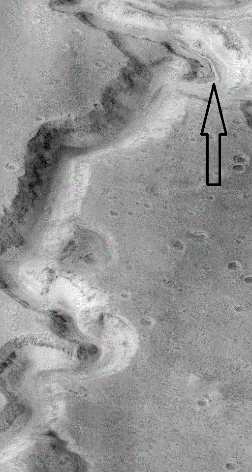
| 08:07, 11 April 2018 | Nanedivallesmoc2.gif (file) |  |
135 KB | Suitupandshowup | Nanedi Vallis, as seen by the Mars Orbiter Camera (MOC) on Mars Global Surveyor Arrow shows location of small channel on floor Image Credit: Malin Space Science Systems/NASA Source: http://www.msss.com/mars_images/moc/2_2_98_release/8704/index.html | 1 |
| 08:03, 11 April 2018 | Nanedivallesmoc.gif (file) |  |
135 KB | Suitupandshowup | Close view of Nanedi Vallis, as seen by the Mars Orbiter Camera (MOC) on the Mars Global Surveyor spacecraft Arrow shows location of small channel on floor Source: http://www.msss.com/mars_images/moc/2_2_98_release/8704/index.html Image Credit: Ma... | 1 |


