File list
This special page shows all uploaded files.
| Date | Name | Thumbnail | Size | User | Description | Versions |
|---|---|---|---|---|---|---|
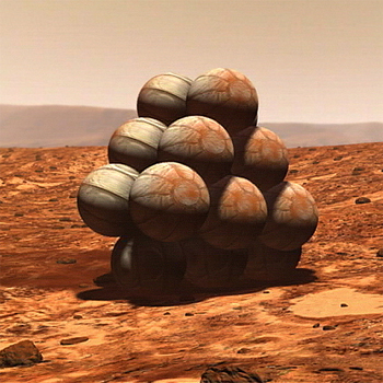
| 15:03, 29 October 2018 | Pathfinder-airbag-landing-concept.jpg (file) |  |
146 KB | Suitupandshowup | Drawing showing how Pathfinder landed The craft was surrounded by giant air bags. It bounced several times before coming to rest. And then the air bags deflated and were pulled away. Source: https://mars.nasa.gov/programmissions/missions/past/path... | 1 |
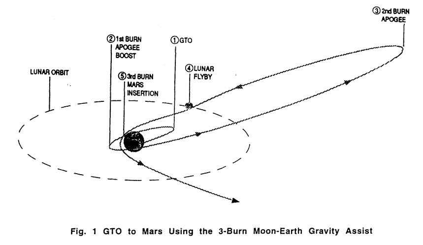
| 19:51, 24 October 2018 | GTO-to-Mars.png (file) |  |
72 KB | Pb | GOT to Mars using the 2-burn Moon-Earth gravity assist. From "Mission design for Mars mission using the Ariane ASAP launch capability," by Paul Penzo, 1999. https://trs.jpl.nasa.gov/bitstream/handle/2014/16879/99-0288.pdf?sequence=1 | 1 |
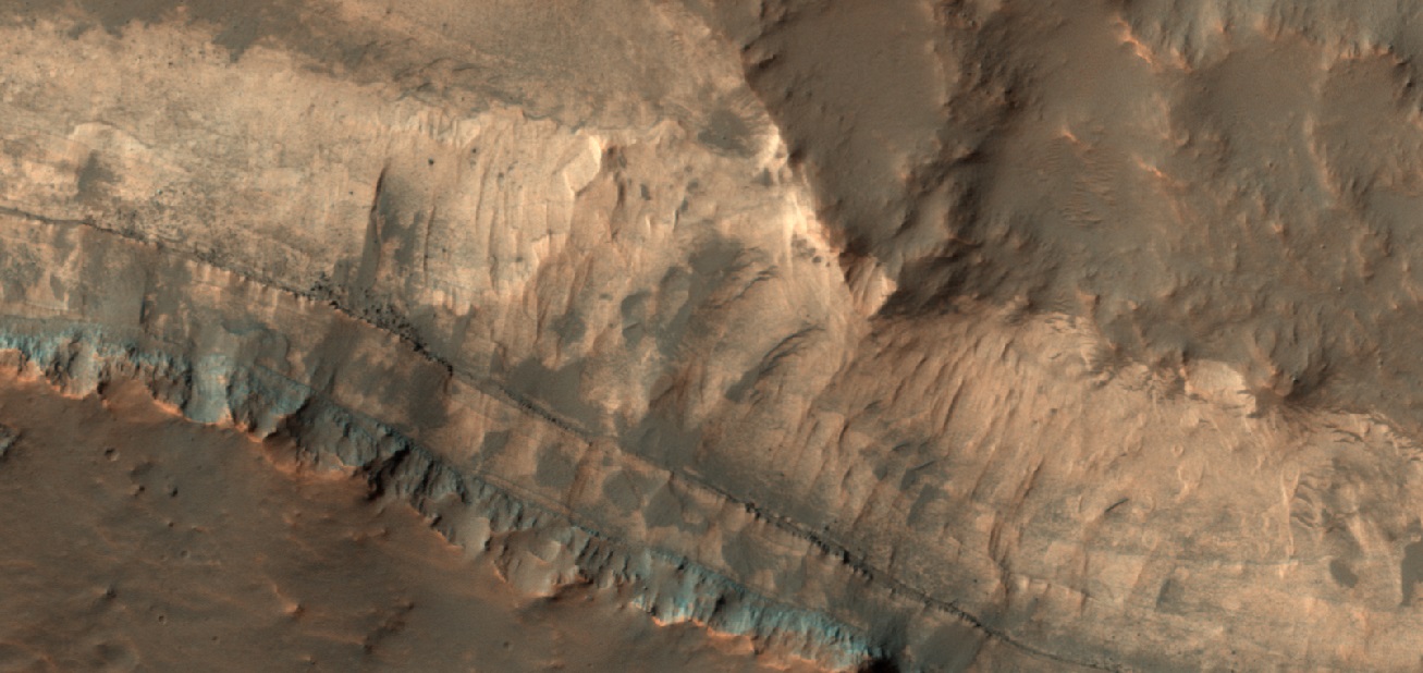
| 08:14, 24 October 2018 | 54710 1495layerscolor.jpg (file) |  |
226 KB | Suitupandshowup | Close, color view of layers, as seen by HiRISE under HiWish program Source: http://hirise.lpl.arizona.edu/ESP_54710_1495 Image credit: NASA/JPL/University of Arizona/Secosky | 1 |
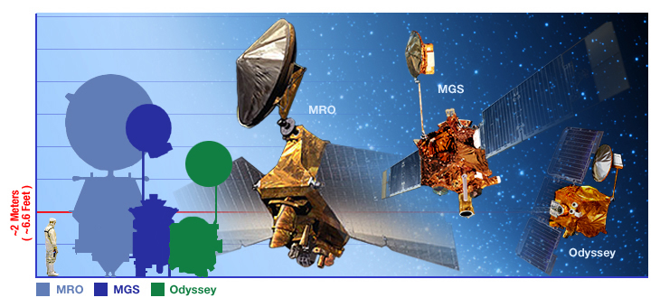
| 07:57, 24 October 2018 | Mars orbiters.jpg (file) |  |
236 KB | Suitupandshowup | The Mars Reconnaisance Orbiter is a massive and capable spacecraft; it dwarfs its predecessors, Mars Global Surveyor and Mars Odyssey. Source: http://mars.jpl.nasa.gov/mro/gallery/artwork/mars_orbiters.html (image link) Image credit: NASA/JPL | 1 |
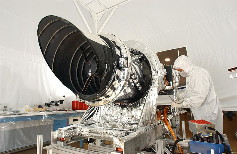
| 16:34, 22 October 2018 | Mars Reconnaissance Orbiter HiRISE.jpg (file) |  |
113 KB | Suitupandshowup | HiRISE camera of the Mars Reconnaissance Orbiter (NASA). Original description: The high resolution imaging science experiment (Hirise) is one of six science instruments for NASA's Mars Reconnaissance Orbiter. The orbiter is scheduled for launch in Aug... | 1 |
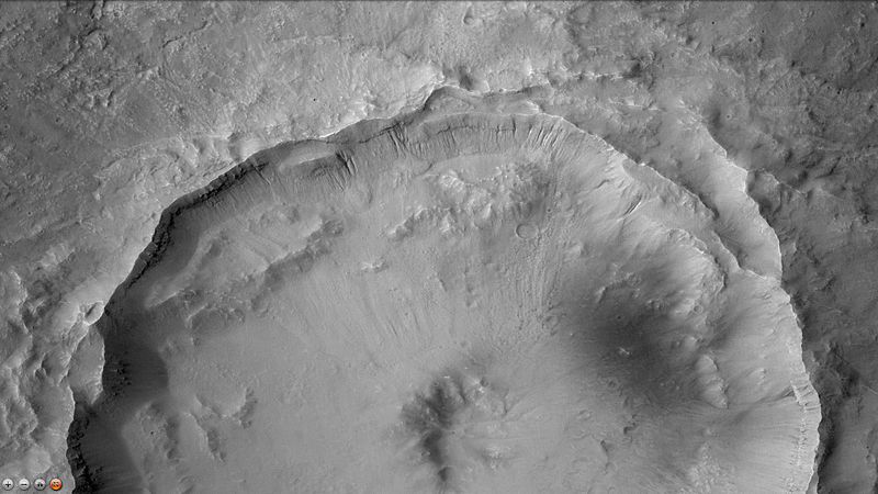
| 16:31, 22 October 2018 | Aureum Chaos HiWish.JPG (file) |  |
50 KB | Suitupandshowup | Enlarged part of image of Aureum Chaos taken under HiWish program. Location is 2.438 S and 332.144 E. Date 4/1/10 Source http://hirise.lpl.arizona.edu/ESP_016869_1775 Image credit: NASA/JPL/University of Arizona/Secosky | 1 |
| 16:27, 22 October 2018 | Aureum Chaos wide viewhirise.JPG (file) |  |
28 KB | Suitupandshowup | Wide view of Aureum Chaos, one of first 8 images released in public suggestion program. Location is 2.438 S and 332.144 E. Date 4/1/10 Source http://hirise.lpl.arizona.edu/ESP_016869_1775 Image source: NASA/JPL/University of Arizona/Secosky | 1 |
| 16:22, 22 October 2018 | Aureum Chaos wide context.JPG (file) |  |
79 KB | Suitupandshowup | Themis Day IR showing wide context for other images. Black box is approximate location of HiRISE image. Center longitude is 333.06 E Date 1 April 2010 Source http://viewer.mars.asu.edu/planetview/inst/ctx/P03_002325_1757_XN_045027W#start Image credit:... | 1 |
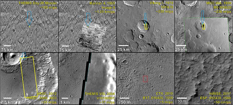
| 16:00, 22 October 2018 | ESP 052438 1560-2compositemanypictures.jpg (file) |  |
126 KB | Suitupandshowup | Composite demonstrating relative resolution of 7 different cameras that imaged Mars: HiRISE (Mars Reconnaissance Orbiter), THEMIS VIS (Mars Odyssey), MOC-WAC (Mars Global Surveyor), HRSC (Mars Express), CTX (Mars Reconnaissance Orbiter), Viking, Marine... | 1 |
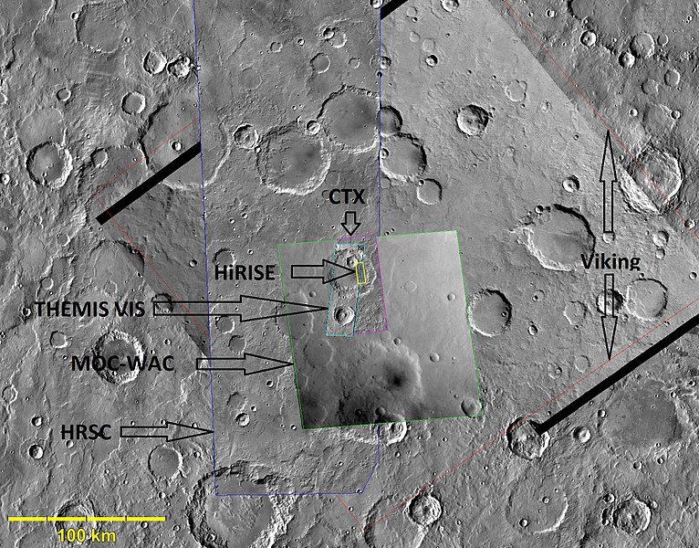
| 15:56, 22 October 2018 | ESP 052438 1560-1differentspacecraftpicturesarrows.jpg (file) |  |
198 KB | Suitupandshowup | Composite demonstrating relative resolution of 7 different cameras that imaged Mars: HiRISE (Mars Reconnaissance Orbiter), THEMIS VIS (Mars Odyssey), MOC-WAC (Mars Global Surveyor), HRSC (Mars Express), CTX (Mars Reconnaissance Orbiter), Viking, Marine... | 1 |
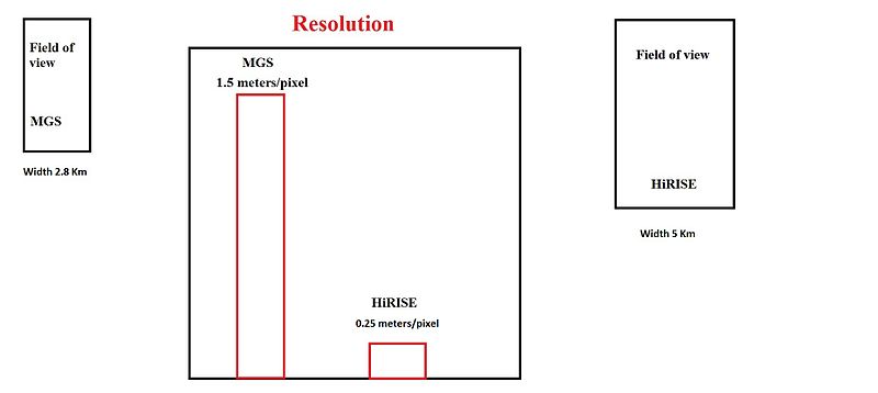
| 15:48, 22 October 2018 | Fall36camerascomparedwidthslabeled.jpg (file) |  |
15 KB | Suitupandshowup | Diagram showing the relative size of MGS and HiRISE images Image credit: Jim Secosky | 1 |
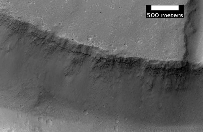
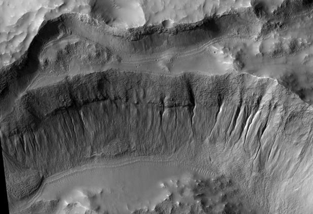
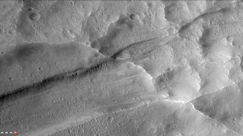
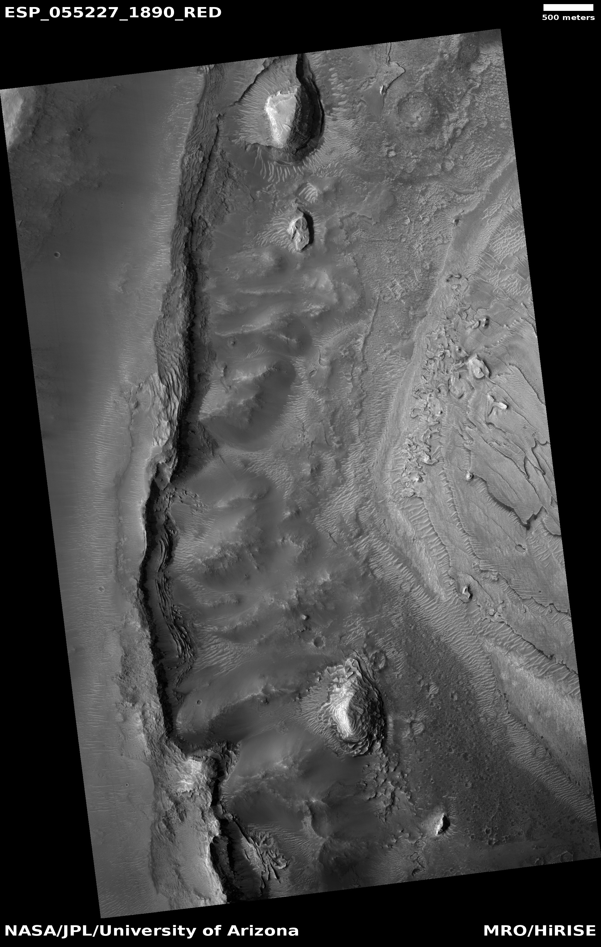
| 15:39, 22 October 2018 | Crater wall inside Mariner Crater.JPG (file) |  |
47 KB | Suitupandshowup | Crater wall inside Mariner Crater showing gullies, as seen by HiRISE. Location is 34.9 degrees south latitude and 195.1 degrees east longitude. Image was taken by the Mars Reconnaissance Orbiter's HiRISE. Image credit: NASA/JPL/University of Arizona... | 1 |
| 15:35, 22 October 2018 | Wikimarinergullies.jpg (file) |  |
65 KB | Suitupandshowup | Part of Mariner Crater, as seen by CTX This covers part of Mariner 4 images and shows gullies in a crater on the floor of Mariner Crater. Some of the gullies have been imaged with HiRISE. Source: http://viewer.mars.asu.edu/planetview/inst/ctx/P11_00521... | 1 |
| 15:33, 22 October 2018 | Wikimarinertrough.jpg (file) |  |
80 KB | Suitupandshowup | Part of Mariner Crater, as seen by CTX This covers part of Mariner 4 images and shows troughs with possible gullies of Mariner Crater. The troughs go across the southern edge of crater. Date 20 December 2014 Source: http://viewer.mars.asu.edu/planetvie... | 1 |
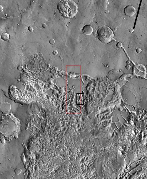
| 15:30, 22 October 2018 | Marinerctxboxes.jpg (file) |  |
46 KB | Suitupandshowup | CTX image with black and red boxes showing locations of pictures taken with HiRISE Source http://viewer.mars.asu.edu/planetview/inst/ctx/P11_005218_1452_XN_34S165W#P=P11_005218_1452_XN_34S165W&T=2 Author Jim Secosky modified NASA image NASA/Malin Spac... | 1 |
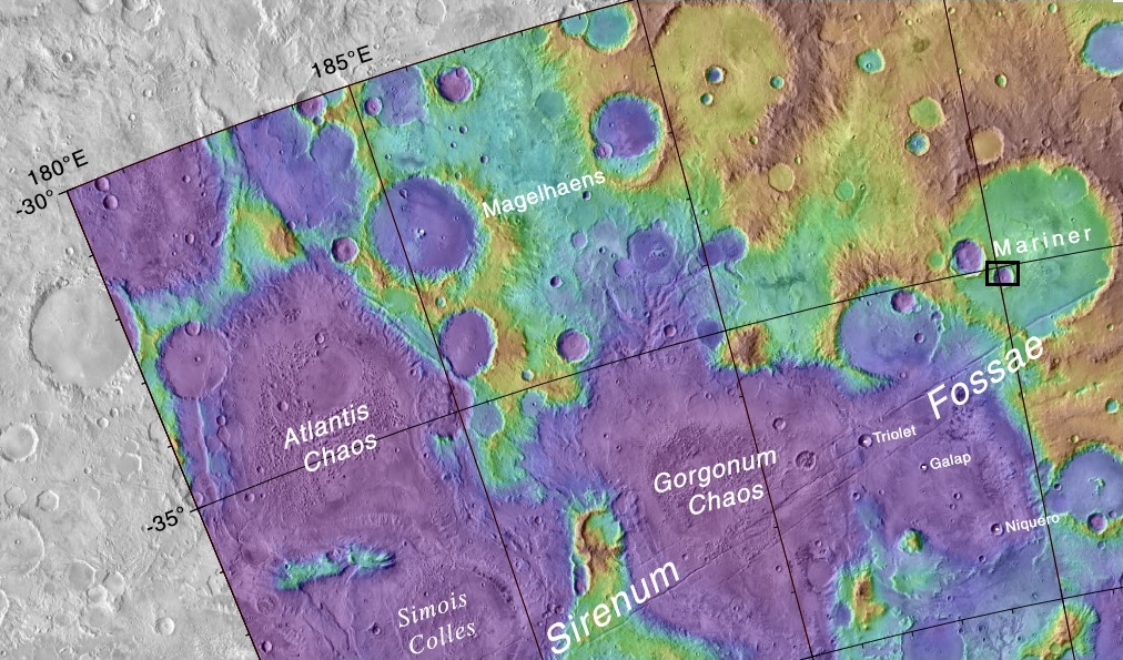
| 15:27, 22 October 2018 | Mapmariner.jpg (file) |  |
315 KB | Suitupandshowup | Labeled topographic map showing area around Mariner Crater Black and red boxes show locations of some pictures from CTX and HiRISE. Source https://planetarynames.wr.usgs.gov/images/mc24_2014.pdf Author Jim Secosky modified NASA image NASA/USGS/Secosky | 1 |
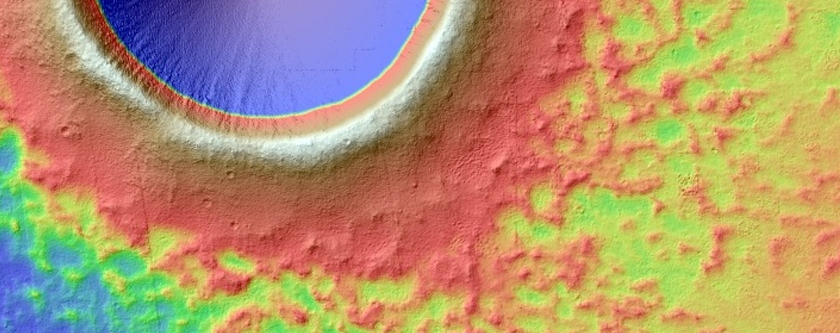
| 15:19, 22 October 2018 | PSP 005837 1965cratercolor.jpg (file) |  |
233 KB | Suitupandshowup | Crater showing topography with different colors Source: http://hirise.lpl.arizona.edu/PSP_005837_1965 and http://hirise.lpl.arizona.edu/PSP_005903_1965. Image credit: NASA/JPL/University of Arizona | 1 |
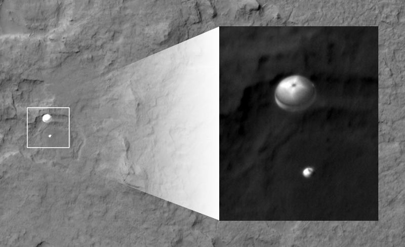
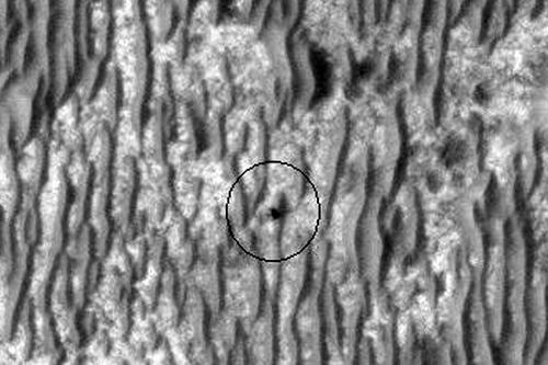
| 14:50, 22 October 2018 | MRO sees Curiosity landing.jpg (file) |  |
43 KB | Suitupandshowup | NASA's Curiosity rover and its parachute were spotted by NASA's Mars Reconnaissance Orbiter as Curiosity descended to the surface on 5 Aug 2012 PDT (6 Aug EDT). The High-Resolution Imaging Science Experiment (HiRISE) camera captured this image of Curio... | 1 |
| 14:46, 22 October 2018 | Opportunity Rover by HiRISE.jpg (file) |  |
52 KB | Suitupandshowup | Opportunity Rover as seen by HiRISE. Image taken 1/29/09 at 2.1 South and 354.5 E. Date 6 June 2009 Source http://hirise.lpl.arizona.edu/ESP_011765_1780 Picture credit: NASA/JPL/University of Arizona | 1 |
| 14:42, 22 October 2018 | Opportunity Tracks.jpg (file) |  |
115 KB | Suitupandshowup | Opportunity Tracks, as seen by hirise. Location is 2.1 South and 354.5 East. Date 4 June 2009 Source hirise.lpl.arizona.edu/PSP_004289_1780 Picture credit: NASA/JPL/University of Arizona | 1 |
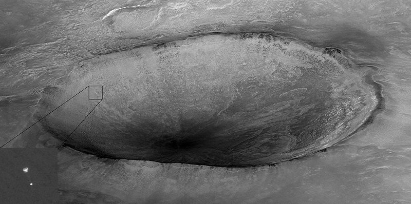
| 14:39, 22 October 2018 | Phoenix with a crater in the background taken by Mars Reconnaissance Orbiter.jpg (file) |  |
109 KB | Suitupandshowup | Image taken by Mars Reconnaissance Orbiter showing descent of Phoenix with a crater in the background. Original caption from NASA: "Mars Reconnaissance Orbiter's High Resolution Imaging Science Experiment (HiRISE) camera acquired this image of Phoenix... | 1 |
| 09:00, 22 October 2018 | Coneselysium.jpg (file) |  |
119 KB | Suitupandshowup | Cones This arrangement of cones was formed by hot lava flowing over icy ground. Ice changed to steam and made these cones. Rafts of lava are also visible to the right. The location is the Elysium quadrangle at 26.029° N and 172.936° E (ESP_037643_2... | 1 |
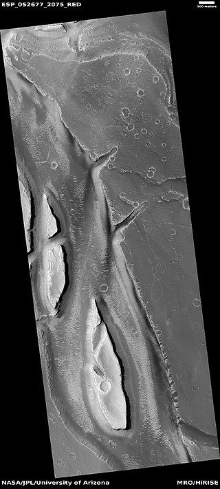
| 08:53, 22 October 2018 | 27657392 10211535607485206 6751244250901339355 nstreamlined.jpg (file) |  |
44 KB | Suitupandshowup | Streamlined features in channel The location is the Elysium quadrangle at 27.4° N and 135.7 E(ESP_052677_2075). Image credit is NASA/JPL/University of Arizona. Source: http://hirise.lpl.arizona.edu/ESP_052677_2075 | 1 |
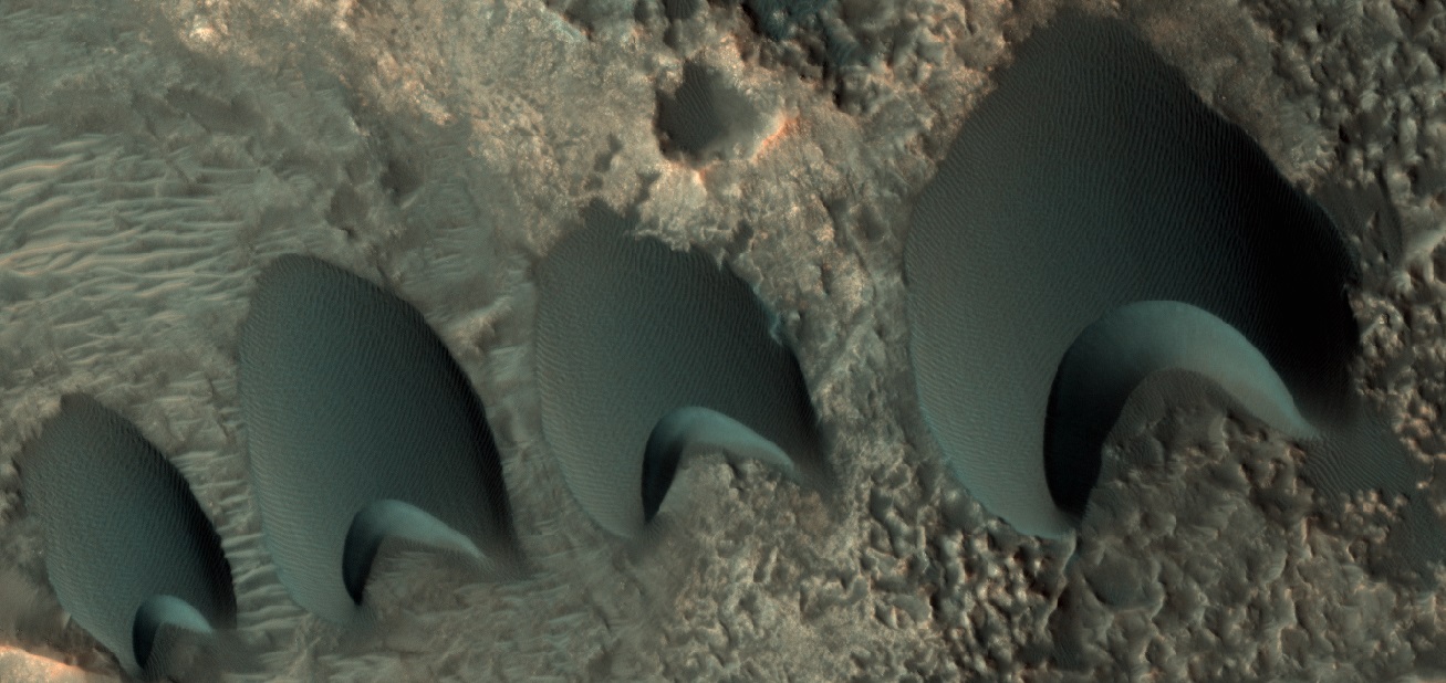
| 08:38, 22 October 2018 | 55095 2170dunelinecolor.jpg (file) |  |
254 KB | Suitupandshowup | Sand dunes, as seen by HiRISE under HiWish program Dark color is from dark minerals in the volcanic rock called basalt. Source: http://hirise.lpl.arizona.edu/ESP_55095_2170 Image credit: NASA/JPL/University of Arizona/Secosky | 1 |
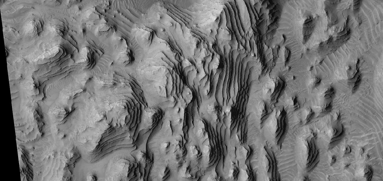
| 08:14, 22 October 2018 | 54858 1885bottomlayers.jpg (file) |  |
356 KB | Suitupandshowup | Wide view of layers, as seen by HiRISE under HiWish program Layers may have formed with the aid of water. Source: http://hirise.lpl.arizona.edu/ESP_54858_1885 Image credit: NASA/JPL/University of Arizona/Secosky | 1 |
| 07:56, 22 October 2018 | 55227 1890layeredmound.jpg (file) |  |
211 KB | Suitupandshowup | Close, color view of layers in mound, as seen by HiRISE under HiWish program Picture was enlarged using the HiView program Source: http://hirise.lpl.arizona/ESP_55227_1890 Image credit: NASA/JPL/University of Arizona/Secosky | 1 |
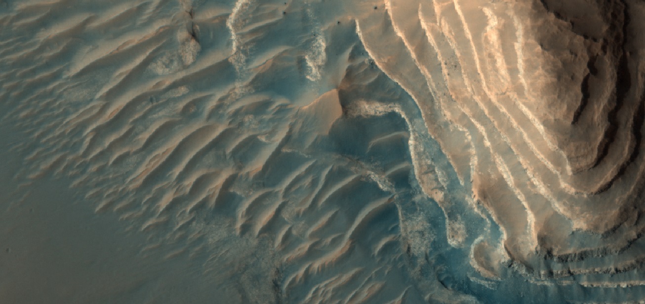
| 07:52, 22 October 2018 | 55227 1890layeredmoundwide.jpg (file) |  |
265 KB | Suitupandshowup | Layered mound, as seen by HiRISE under HiWish program Source: http://hirise.lpl.arizona.edu/ESP_55227_1890 Image credit: NASA/JPL/University of Arizona/Secosky | 1 |
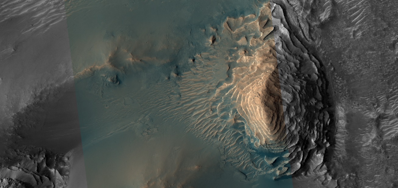
| 07:48, 22 October 2018 | ESP 055227 1890layeredmound.jpg (file) |  |
1.52 MB | Suitupandshowup | Wide view of layers and layered mounds, as seen by HiRISE under HiWish program Source: http://hirise.lpl.arizona.edu/ESP_055227_1890 Image credit: NASA/JPL/University of Arizona | 1 |
| 13:32, 16 October 2018 | HAL-MDRS.png (file) |  |
11 KB | Jburk | 1 | |
| 08:38, 11 October 2018 | R0502109dorsaargentea.jpg (file) |  |
51 KB | Suitupandshowup | Dorsa Argentea in south polar region of Mars, as seen by Mars Global Surveyor MOC Location is 76 S and 318 E. Source: http://www.msss.com/moc_gallery/r03_r09/images/R05/R0502109.html Image credit: NASA/JPL/Malin Space Science Systems/Secosky | 1 |
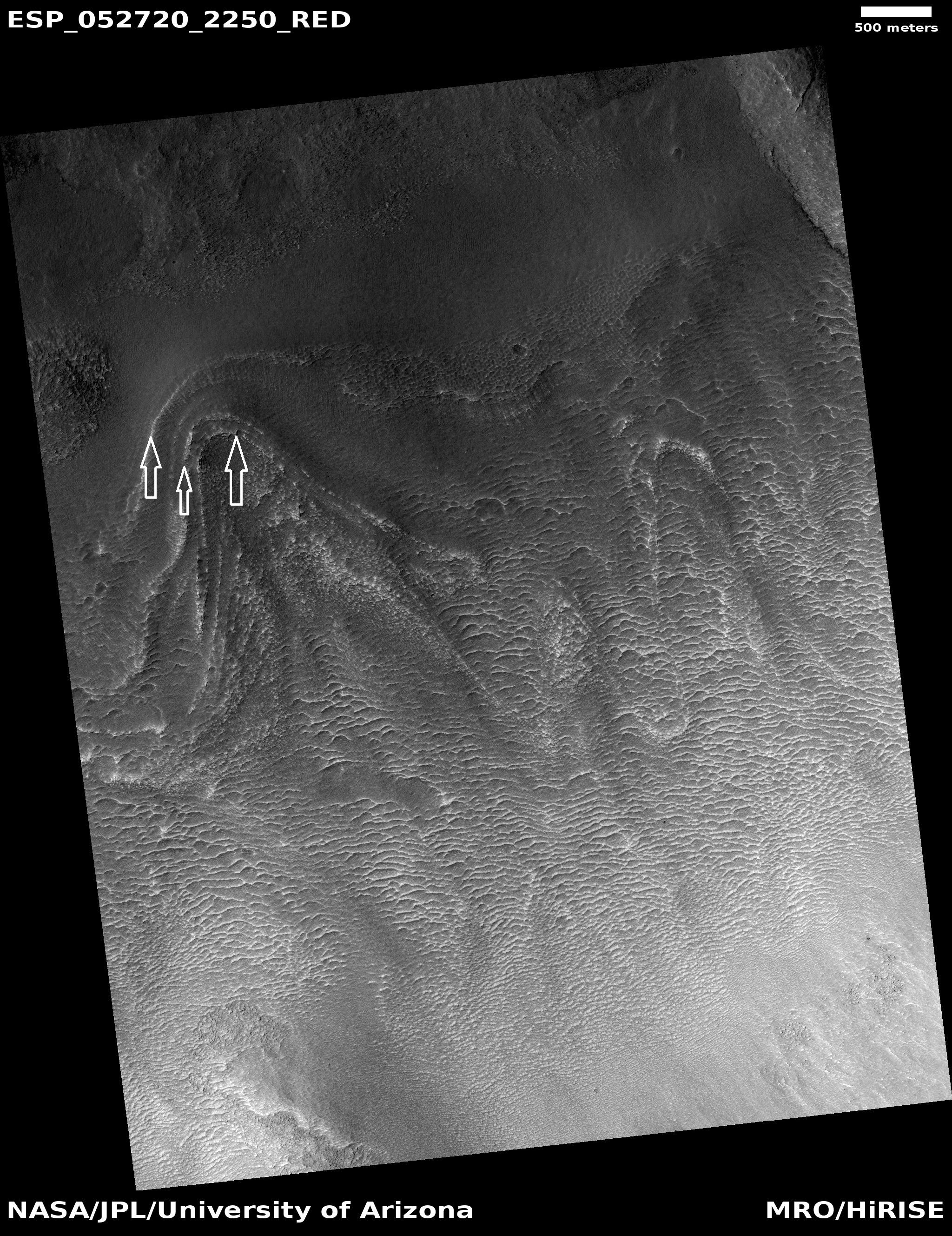
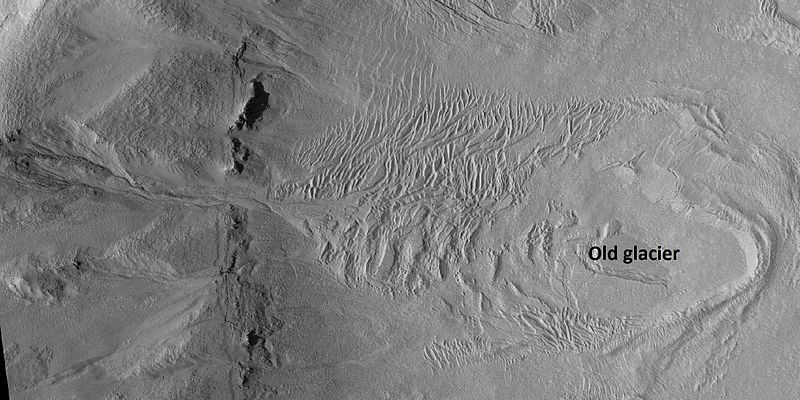
| 08:00, 9 October 2018 | Moraines52720 2250.jpg (file) |  |
1.95 MB | Suitupandshowup | Old glacier showing multiple moraines, as seen by HiRISE under HiWish program White arrows point to 3 different moraines. As the glacier retreated, it left a moraine. Source: http://hirise.lpl.arizona.edu/ESP_052720_2250 Image credit: NASA/JPL/Un... | 1 |
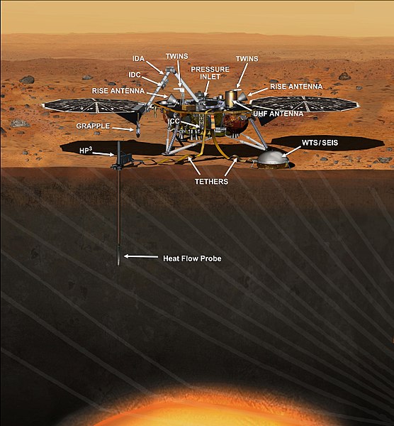
| 18:41, 8 October 2018 | PIA17358-MarsInSightLander-20140326.jpg (file) |  |
76 KB | Suitupandshowup | PIA17358: Artist's Concept of InSight Lander on Mars Source: http://photojournal.jpl.nasa.gov/catalog/PIA17358 This artist's concept depicts the stationary NASA Mars lander known by the acronym InSight at work studying the interior of Mars. The InSig... | 1 |
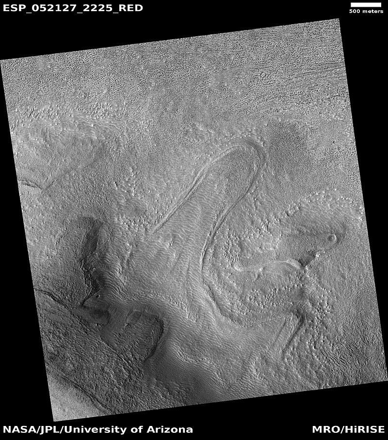
| 18:28, 8 October 2018 | Tongueismenius.jpg (file) |  |
159 KB | Suitupandshowup | Tongue-shaped glacier, as seen by HiRISE under HiWish program Source: http://hirise.lpl.arizona.edu/ESP_052127_2225 | 1 |
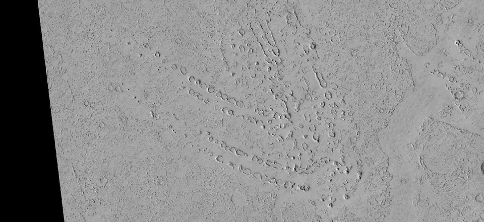
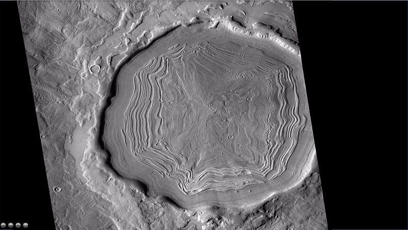
| 18:21, 8 October 2018 | 30707946 10212010896087124 5214252926280663040 nccf.jpg (file) |  |
60 KB | Suitupandshowup | Concentric crater fill, as seen by CTX The location is the Casius quadrangle at 38° N and 75.6° E (ESP_018144_2185). Source: http://viewer.mars.asu.edu/planetview/inst/ctx/B22_018144_2182_XN_38N284W#P=B22_018144_2182_XN_38N284W&T=2 Image credit... | 1 |
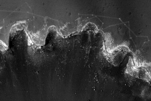
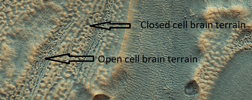
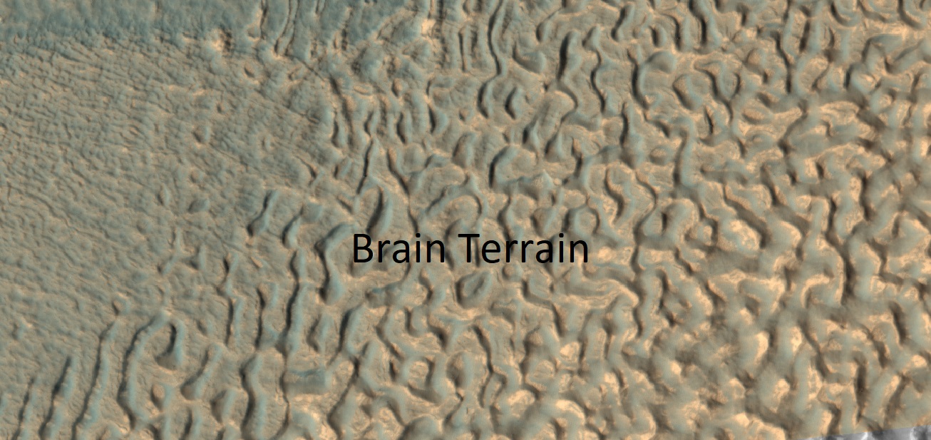
| 18:03, 8 October 2018 | ESP 053642 2225brainslabeled.jpg (file) |  |
205 KB | Suitupandshowup | Open and closed cell brain terrain, as seen by HiRISE under HiWish program The open and closed cell brain terrain are each labeled. Closed brain terrain still contains an ice core. Source: http://hirise.lpl.arizona.edu/ESP_053642_2225 Image credit... | 1 |
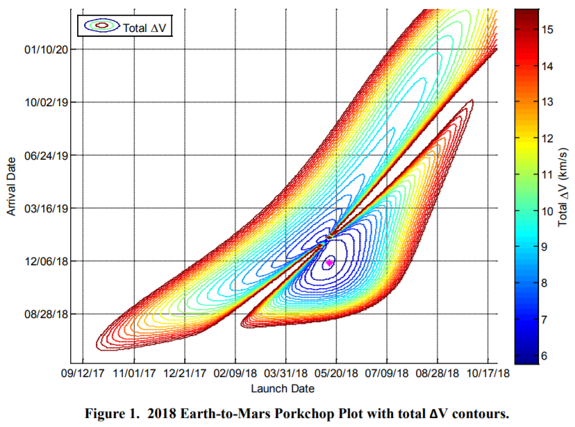
| 17:19, 8 October 2018 | Porkchopplot.png (file) |  |
343 KB | Pb | Example porkchop plot for Earth-Mars transfer in the 2018 window. https://trs.jpl.nasa.gov/bitstream/handle/2014/44336/13-0679_A1b.pdf?sequence=1 Ryan C. Woolley and Charles W. Whetsel "On the nature of Earth-Mars porkchop plots" 2014 AAS | 1 |
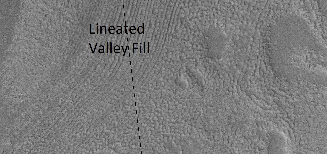
| 16:37, 8 October 2018 | 56544 2200lvfbrains.jpg (file) |  |
402 KB | Suitupandshowup | Wide view of lineated valley fill, as seen by HiRISE under HiWish program Picture taken during the end of a global dust storm. Source: http://hirise.lpl.arizona.edu/ESP_056544_2200 Image credit: NASA/JPL/University of Arizona/Secosky | 1 |
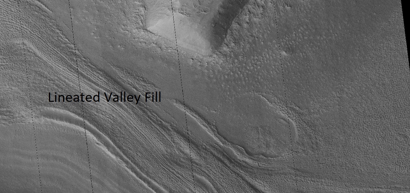
| 16:29, 8 October 2018 | 56544 2200lvf.jpg (file) |  |
388 KB | Suitupandshowup | Close view of Lineated Valley fill, as seen by HiRISE under HiWish program Image was taken during the end of a global dust storm. Source: http://hirise.lpl.arizona.edu/ESP_056544_2200 Image credit: NASA/JPL/University of Arizona/Secosky | 1 |
| 16:21, 8 October 2018 | Marspedia Intership Program Flyer.pdf (file) | 158 KB | Jburk | 1 | ||
| 16:12, 8 October 2018 | 44410 2195glacier.jpg (file) |  |
83 KB | Suitupandshowup | Old glacier in Casius quadrangle, as seen by HiRISE under HiWish program Source: http://hirise.lpl.arizona.edu/ESP_044410_2195 Image credit: NASA/JPL/ University of Arizona/Secosky | 1 |
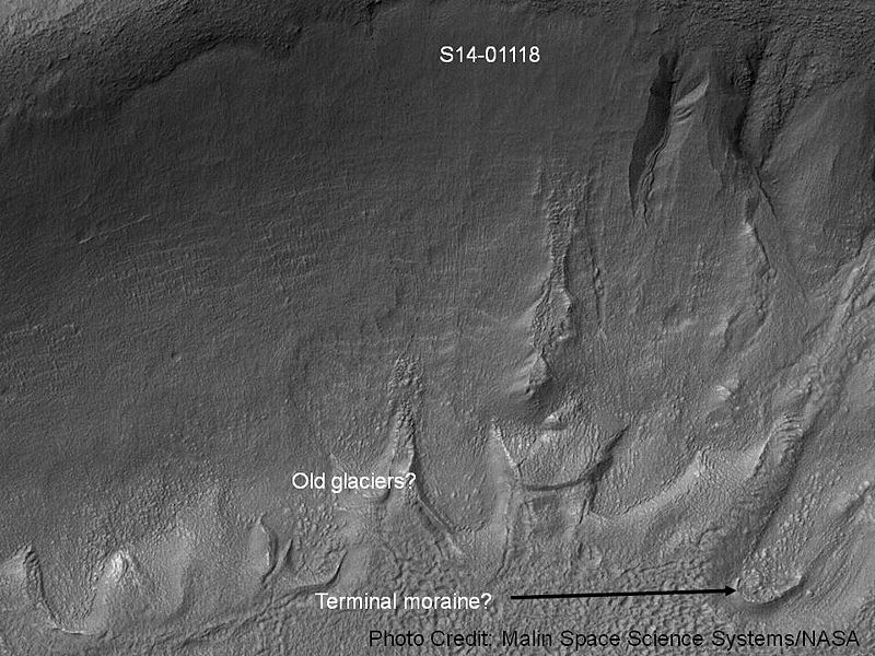
| 16:06, 8 October 2018 | Gullies and tongue-shaped glacier.jpg (file) |  |
117 KB | Suitupandshowup | Gullies and remains of old glaciers This image was taken with the Mars Orbital Camera MOC) on the Mars Global Surveyor MGS). It's id number is S14-01118, and its location is 222.93 degrees west longitude and 37.43 degrees south latitude. The photo c... | 1 |
| 15:57, 8 October 2018 | 54527 2225brainsclosecolor.jpg (file) |  |
284 KB | Suitupandshowup | Close, color view of brain terrain Source: https://www.uahirise.org/ESP_054527_2225 Image credit: NASA/JPL/University of Arizona/Secosky | 1 |
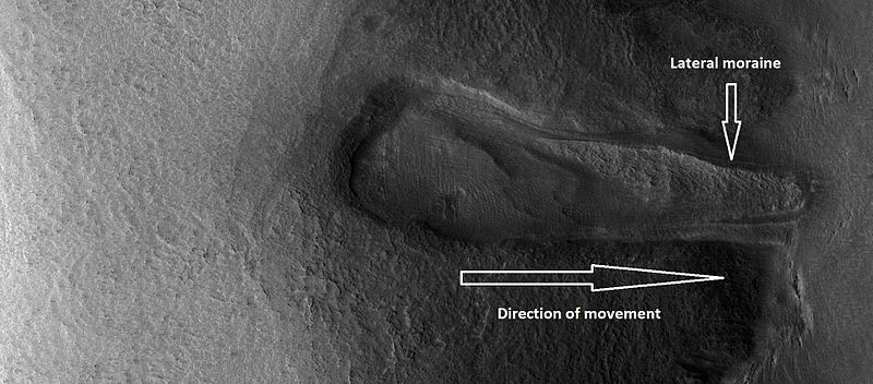
| 15:40, 8 October 2018 | ESP 028352 2245glacier.jpg (file) |  |
67 KB | Suitupandshowup | Glacier flowing down valley It has lost most of its ice, but has left a moraine. Source: http://hirise.lpl.arizona.edu/ESP_028352_2245 Image credit: NASA/JPL/University of Arizona/Secosky | 1 |
| 08:05, 6 October 2018 | HAL.png (file) |  |
65 KB | Jburk | 1 | |
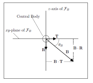
| 07:24, 3 October 2018 | B Plane Targeting.png (file) |  |
14 KB | Pb | Diagram of the "B-Plane" used in targeting for interplanetary maneuvers including gravity assists, orbital insertion, and atmospheric entry. Image courtesy NASA, taken from GMAT tutorial on B-Plane targeting: http://gmat.sourceforge.net/docs/R2018a/he... | 1 |
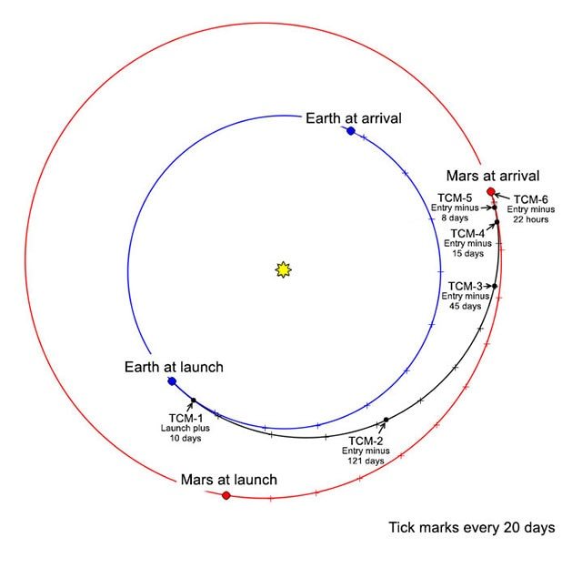
| 06:50, 3 October 2018 | InSight Trajectory.jpg (file) |  |
35 KB | Pb | The trajectory of NASA's InSight lander, including planned trajectory correction maneuvers (TCMs). Image credit NASA/JPL | 1 |
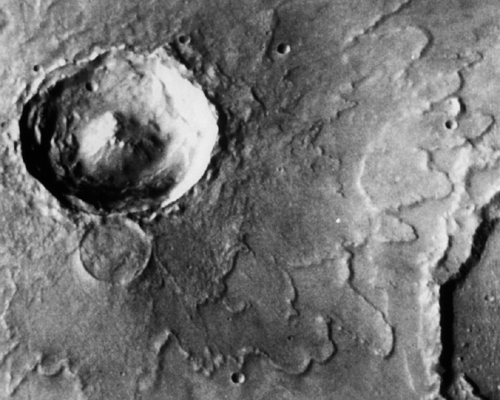
| 15:24, 28 September 2018 | Mars rampart crater.jpg (file) |  |
149 KB | Suitupandshowup | Multiple-layer rampart crater ejecta, Mars; as seen by Viking Source: http://solarsystem.nasa.gov/multimedia/display.cfm?IM_ID=824 Picture credit: NASA | 1 |
| 15:06, 28 September 2018 | MarsLomonosovCraterWinter.jpg (file) |  |
250 KB | Suitupandshowup | The Martian crater Lomonosov in winter as seen by Mars Global Surveyor. The photo credit is Malin Space Science Systems/JPL/NASA. Source: http://mars.jpl.nasa.gov/mgs/msss/camera/images/4_27_00_wintercrater/moc2_msss_crater_100.jpg | 1 |
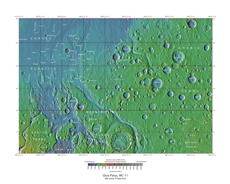
| 08:53, 27 September 2018 | USGS-Mars-MC-11-OxiaPalusRegion-mola.png (file) |  |
649 KB | Suitupandshowup | Labeled typo map of outflow channels in the Oxia Palus region Source: http://planetarynames.wr.usgs.gov/images/mc11_mola.pdf Image credit: USGS (United States Geological Survey) | 1 |
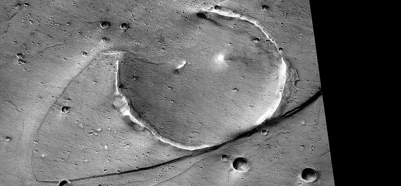
| 08:32, 27 September 2018 | Tsunamisstreamlinedp20008931.jpg (file) |  |
72 KB | Suitupandshowup | Streamlined form eroded on one side by tsunamis, as seen by CTX Image credit: NASA/Malin Space Science Systems/Secosky Image source: http://viewer.mars.asu.edu/planetview/inst/ctx/P20_008931_2108_XI_30N036W#P=P20_008931_2108_XI_30N036W&T=2 | 1 |


