File list
This special page shows all uploaded files.
| Date | Name | Thumbnail | Size | User | Description | Versions |
|---|---|---|---|---|---|---|
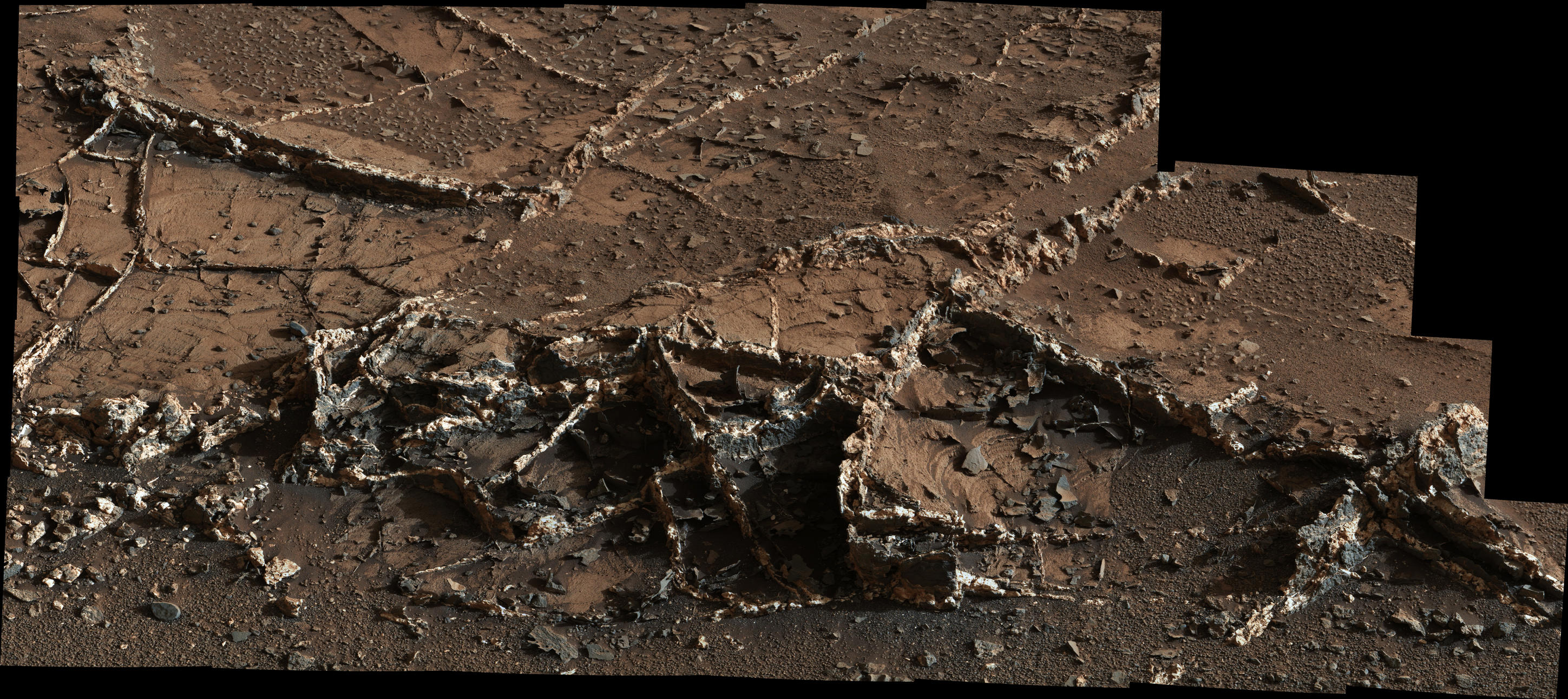
| 09:26, 29 December 2018 | 7056 mars-rover-curiosity-mount-sharp-sol929-pia19161-full2veins.jpg (file) |  |
952 KB | Suitupandshowup | This view from the Mast Camera (Mastcam) on NASA's Curiosity Mars rover shows a network of two-tone mineral veins at an area called "Garden City" on lower Mount Sharp. The veins combine light and dark material. The veins at this site jut to heights of... | 1 |
| 17:00, 28 December 2018 | 5970 PIA17936-MAIN-evening star annotated-full2.jpg (file) |  |
187 KB | Suitupandshowup | The Earth and Moon, as seen from mars by Curiosity Source: https://mars.nasa.gov/news/nasa-mars-rover-curiosity-sees-evening-star-earth/ Image credit: NASA/JPL-Caltech/MSSS/TAMU | 1 |
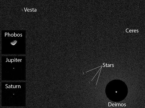
| 16:55, 28 December 2018 | 6205 PIA17937-MAIN ceres annotated1-full2.jpg (file) |  |
44 KB | Suitupandshowup | Planets, moons stars, asteroids, as seen by Curiosity Source: https://mars.nasa.gov/resources/6205/first-asteroid-image-from-the-surface-of-mars-annotated/ Image credit: NASA/JPL-Caltech/MSSS/Texas A&M | 1 |
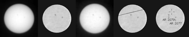
| 16:52, 28 December 2018 | 6314 PIA18389 mercury transit-full2.jpg (file) | 9 KB | Suitupandshowup | This animated blink comparison shows five different versions of observations that NASA's Curiosity rover made about one hour apart while Mercury was passing in front of the sun on June 3, 2014. Two sunspots, each about the diameter of Earth, also appea... | 1 | |
| 16:41, 28 December 2018 | 5001 pia16564 Sol-133 LNav SnakeRiver-full2yellowknife.jpg (file) |  |
86 KB | Suitupandshowup | The sinuous rock feature in the lower center of this mosaic of images recorded by the NASA Mars rover Curiosity is called "Snake River." The location is called "Yellowknife Bay." Source: https://mars.nasa.gov/news/1407/curiosity-rover-explores-yello... | 1 |
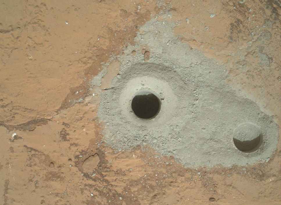
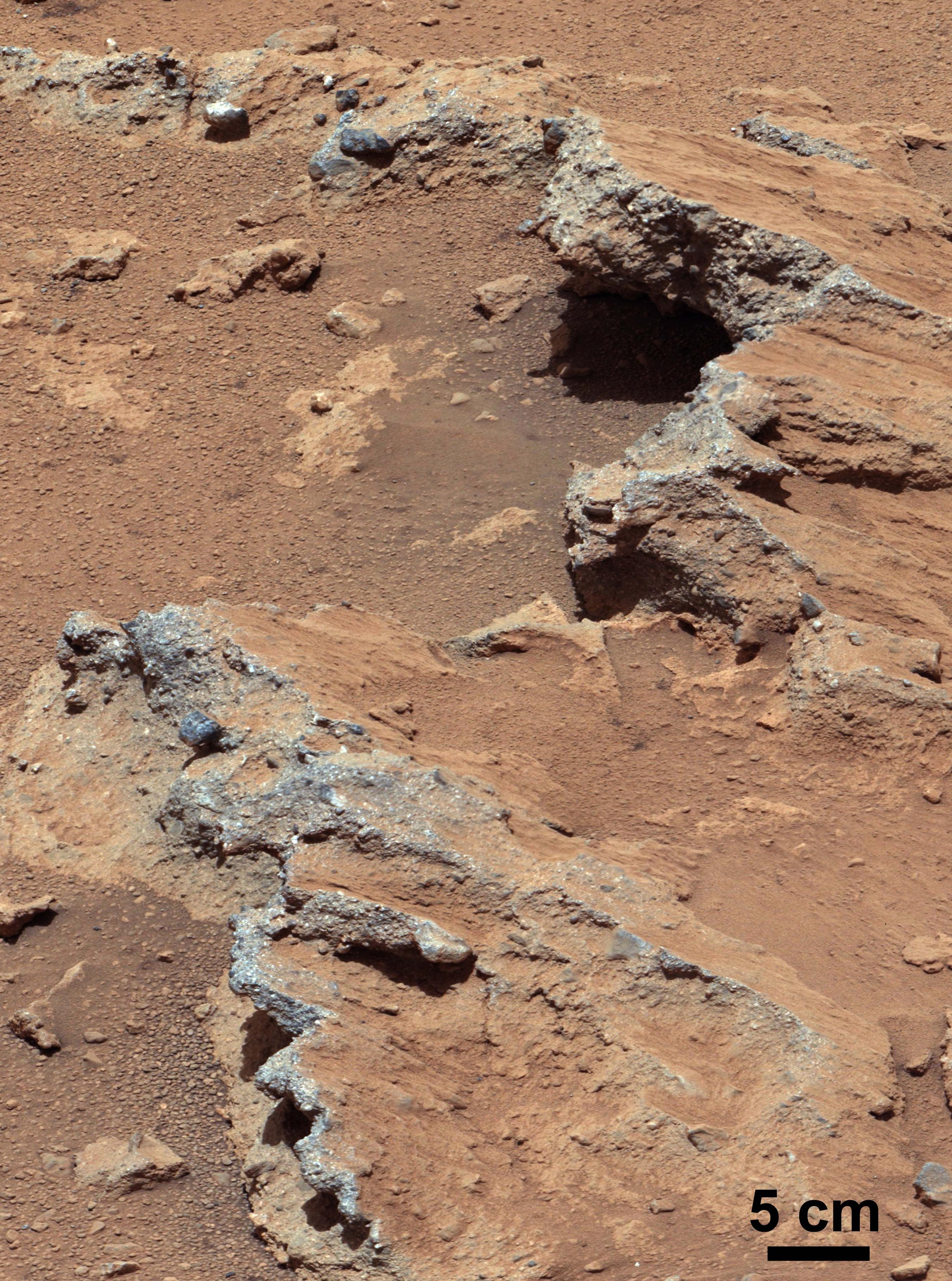
| 16:32, 28 December 2018 | 5073 pia16726-full2john.jpg (file) |  |
129 KB | Suitupandshowup | At the center of this image from NASA's Curiosity rover is the hole in a rock called "John Klein" where the rover conducted its first sample drilling on Mars. The drilling took place on Feb. 8, 2013, or Sol 182, Curiosity's 182nd Martian day of operati... | 1 |
| 16:24, 28 December 2018 | 5316 pia17062 Hottah WB-full2conglomerate.jpg (file) |  |
1.49 MB | Suitupandshowup | NASA's Curiosity rover found evidence for an ancient, flowing stream on Mars at a few sites, including the rock outcrop pictured here, which the science team has named "Hottah" after Hottah Lake in Canada's Northwest Territories. It may look like a bro... | 1 |
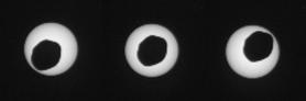
| 16:19, 28 December 2018 | 5536 PIA17356 transit trio-full2eclipse.jpg (file) | 2 KB | Suitupandshowup | This set of three images shows views three seconds apart as the larger of Mars' two moons, Phobos, passed directly in front of the sun as seen by NASA's Mars rover Curiosity. Curiosity photographed this annular, or ring, eclipse with the telephoto-lens... | 1 | |
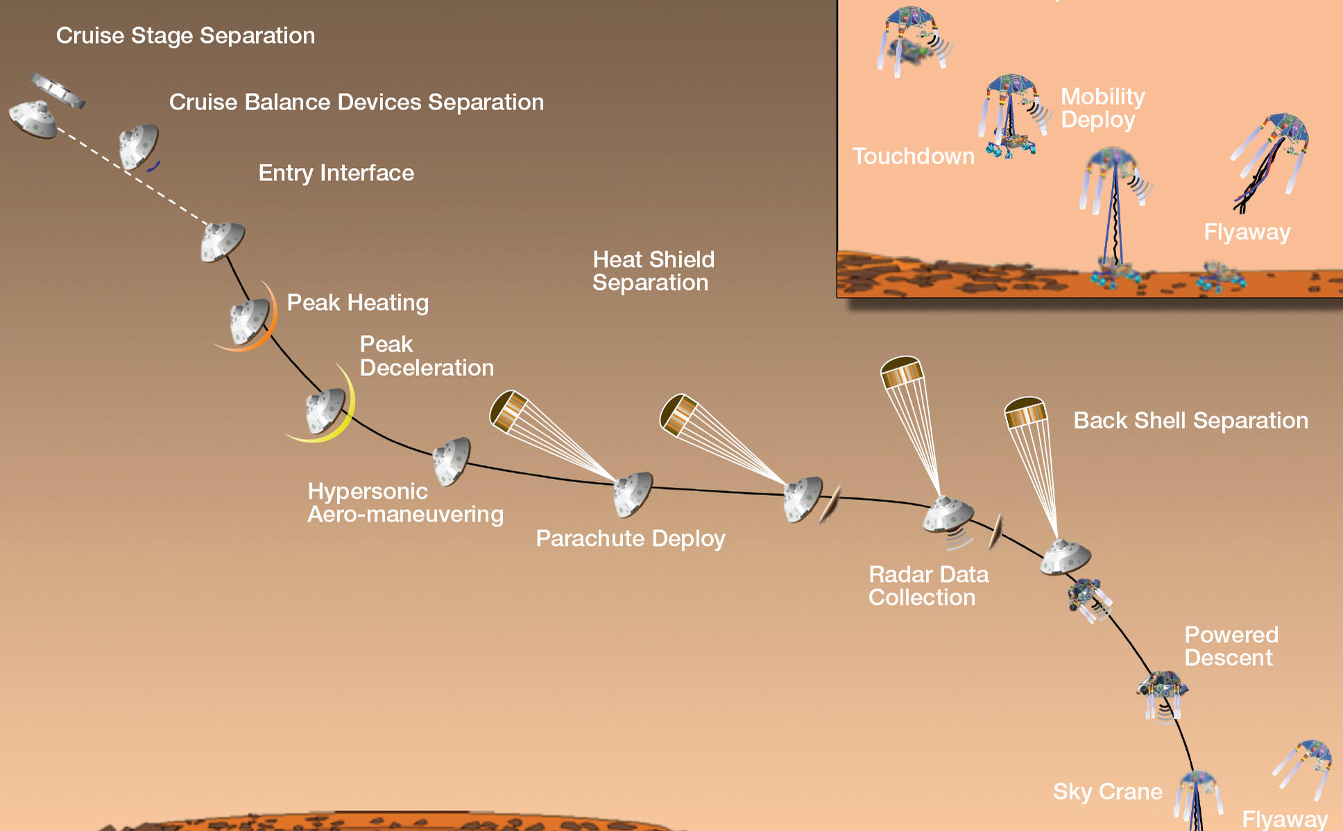
| 16:08, 28 December 2018 | 4392 edl20120809-full2landingsteps.jpg (file) |  |
165 KB | Suitupandshowup | Mission Events During Curiosity's Landing Source: https://mars.nasa.gov/resources/4392/timeline-of-major-mission-events-during-curiositys-landing/ Image credit: NASA/JPL-Caltech | 1 |
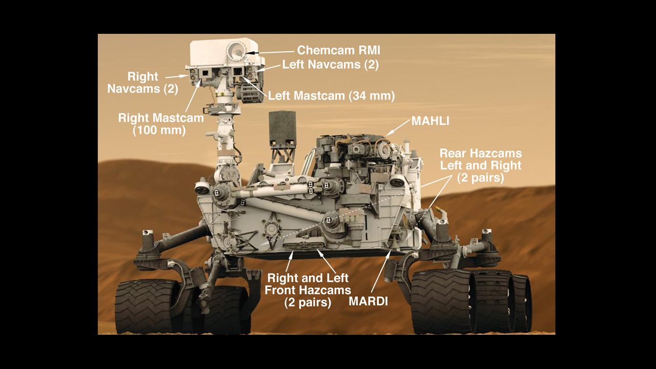
| 13:25, 28 December 2018 | 4077 malin-4rovercam-full.jpg (file) |  |
399 KB | Suitupandshowup | Cameras on Curiosity This graphic shows the locations of the cameras on NASA's Curiosity rover. The rover's mast features seven cameras: the Remote Micro Imager, part of the Chemistry and Camera suite; four black-and-white Navigation Cameras (two on t... | 1 |
| 10:24, 28 December 2018 | Wikimudcracksdense.jpg (file) |  |
102 KB | Suitupandshowup | Close view of mud cracks, as seen by Curiosity. Source http://www.jpl.nasa.gov/spaceimages/details.php?id=pia21263 Image credit: NASA/JPLJPL-Caltech/MSSS | 1 |
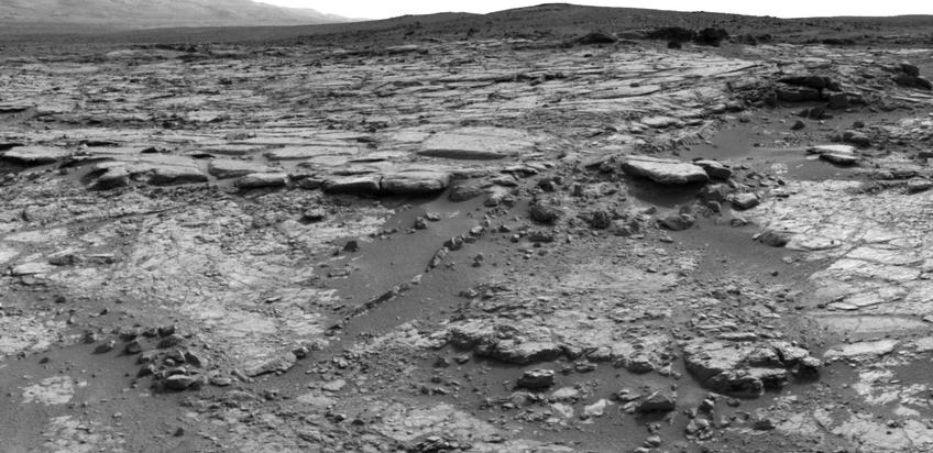
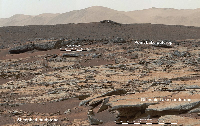
| 10:19, 28 December 2018 | PIA17603 Erosion by Scarp Retreat in Gale Crater, Annotated Version.jpg (file) |  |
141 KB | Suitupandshowup | This mosaic of images from the Mast Camera (Mastcam) instrument on NASA's Curiosity Mars rover shows a series of sedimentary deposits in the Glenelg area of Gale Crater, from a perspective in Yellowknife Bay looking toward west-northwest. The outcrop... | 1 |
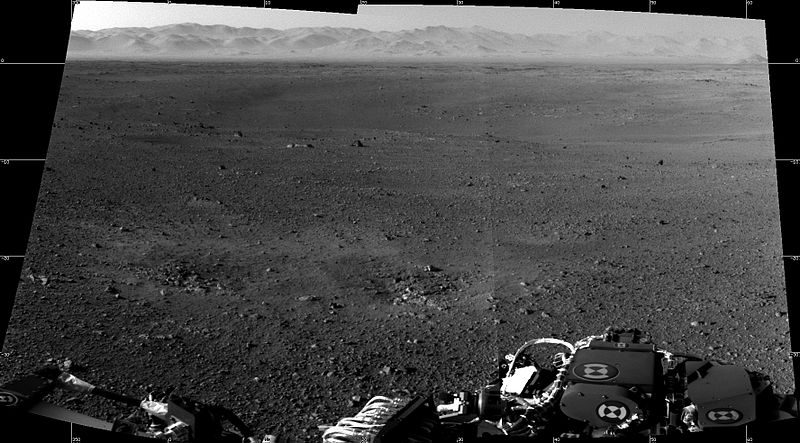
| 10:08, 28 December 2018 | First two full-resolution images from the Curosity rover.jpg (file) |  |
80 KB | Suitupandshowup | These are the first two full-resolution images of the Martian surface from the Navigation cameras on NASA's Curiosity rover, which are located on the rover's "head" or mast. The rim of Gale Crater can be seen in the distance beyond the pebbly ground. T... | 1 |
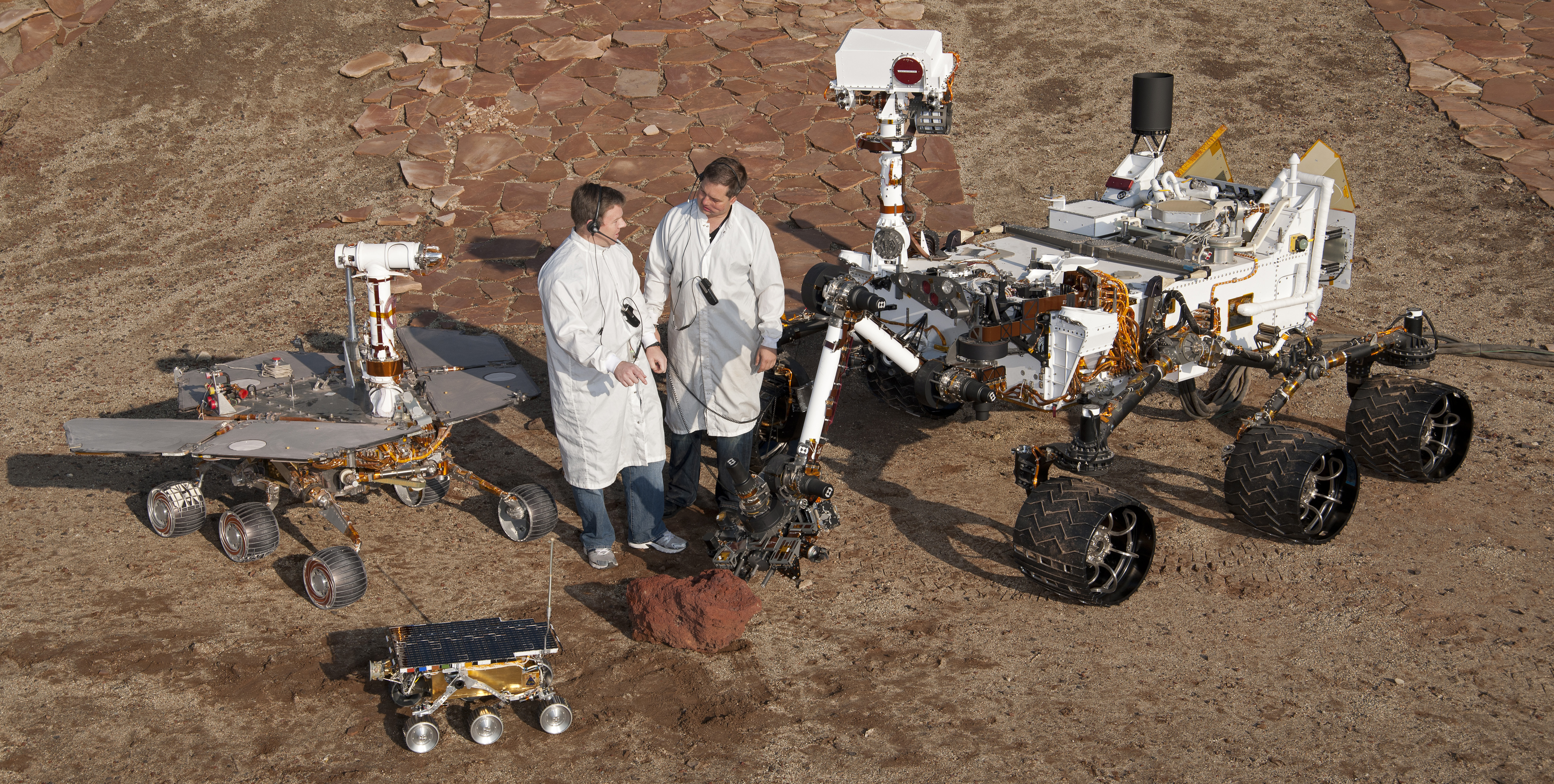
| 09:51, 28 December 2018 | PIA15279 3rovers-stand D2011 1215 D521.jpg (file) |  |
7.34 MB | Suitupandshowup | two spacecraft engineers stand with a group of vehicles providing a comparison of three generations of Mars rovers developed at NASA's Jet Propulsion Laboratory, Pasadena, Calif. The setting is JPL's Mars Yard testing area. Front and center is the flig... | 1 |
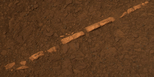
| 18:12, 20 December 2018 | PIA15033 Pancam sol2769 L456atc brvein.jpg (file) |  |
48 KB | Suitupandshowup | 'Homestake' Vein in Color This color view of a mineral vein called "Homestake" comes from the panoramic camera (Pancam) on NASA's Mars Exploration Rover Opportunity. Source: https://mars.jpl.nasa.gov/mer/newsroom/pressreleases/20111207a.html Image... | 1 |
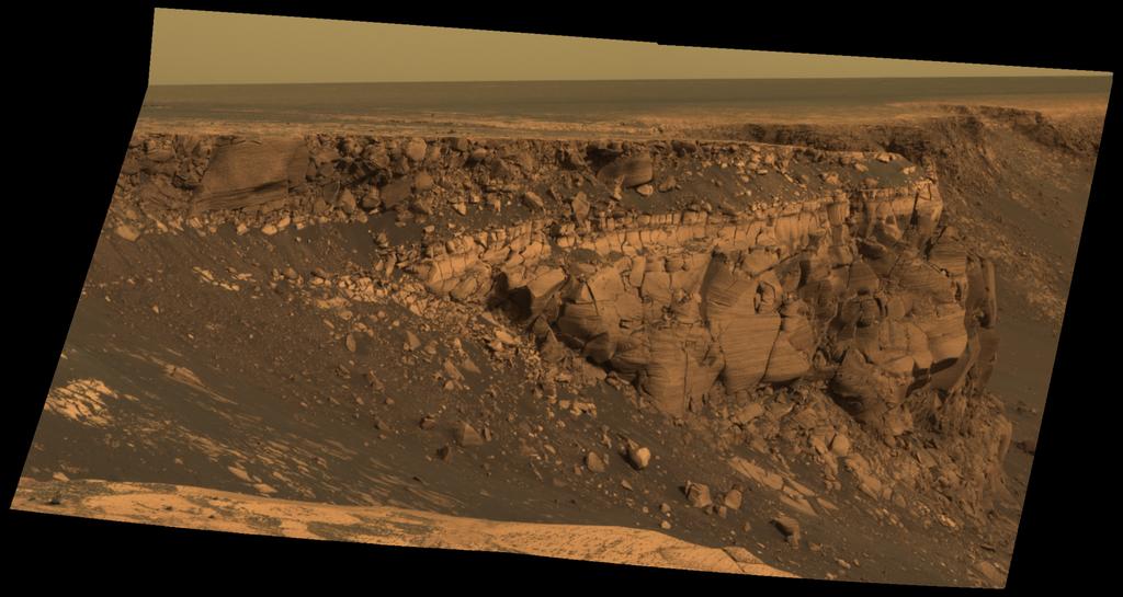
| 17:41, 20 December 2018 | Sol1167B P2419 L257atc br2victoriacrater.jpg (file) |  |
88 KB | Suitupandshowup | This image captured by NASA's Mars Exploration Rover Opportunity shows "Cape St. Vincent," one of the many promontories that jut out from the walls of Victoria Crater, Mars. The material at the top of the promontory consists of loose, jumbled rock, the... | 1 |
| 17:34, 20 December 2018 | PSP 004289 1780 sub bropportunitytracks.jpg (file) |  |
17 KB | Suitupandshowup | Tracks left by NASA's Mars Exploration Rover Opportunity as it traveled along the rim of Victoria Crater can be seen clearly in this image taken by the High Resolution Imaging Science Experiment (HiRISE) camera on NASA's Mars Reconnaissance Orbiter spa... | 1 |
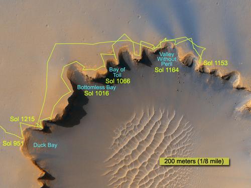
| 17:29, 20 December 2018 | Traverse Near Victoria Sol1215B br.jpg (file) |  |
33 KB | Suitupandshowup | The route followed by NASA's Mars Exploration Rover Opportunity during its exploration partway around the rim of Victoria Crater is marked on this map Source: https://mars.jpl.nasa.gov/mer/newsroom/pressreleases/20070628a.html Image credit: Image cr... | 1 |
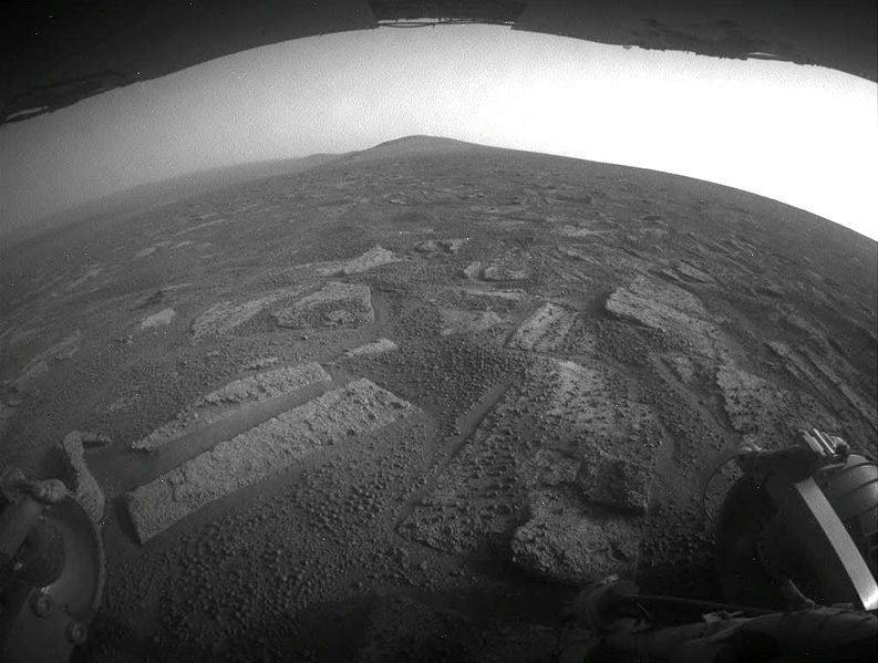
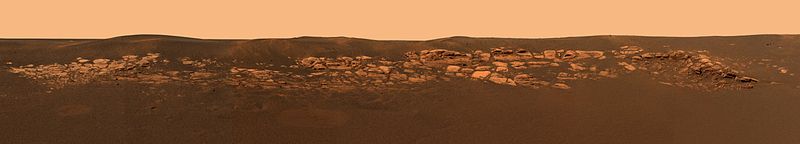
| 16:19, 20 December 2018 | Pia17271 sol3355-rearhaz 3botanybaysolanderpoint.jpg (file) |  |
74 KB | Suitupandshowup | Hazcam image of Botany Bay and Solander Point (2013) Source from http://www.nasa.gov/mission_pages/mer/multimedia/pia17271.html Author NASA/JPL-Caltech (original uploader was Fotaun at English Wikipedia) https://commons.wikimedia.org/wiki/File:Pia17... | 1 |
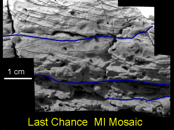
| 16:09, 20 December 2018 | LastChance D JG03-B058R1 br.jpg (file) |  |
229 KB | Suitupandshowup | Interpretations of cross-lamination patterns presented as clues to this martian rock's (nicknamed "Last Chance") origin under flowing water are marked on images taken by the microscopic imager on NASA's Opportunity rover. The microscopic view is a mosa... | 1 |
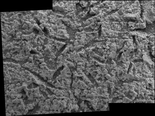
| 15:44, 20 December 2018 | Voids on bedrock on Mars.jpg (file) |  |
61 KB | Suitupandshowup | Voids in rock Large crystals formed and then they dissolved away and left voids of where they were. Source: https://mars.jpl.nasa.gov/mer/gallery/press/opportunity/20040302a.html Image Credit: NASA/JPL/US Geological Survey | 1 |
| 15:33, 20 December 2018 | Meridianiblueberriesdrawing.jpg (file) |  |
29 KB | Suitupandshowup | Drawing shows how "blueberries" (hematite) at Meridiani Planum are believed to have formed. Date 25 January 2012 Source Own work/https://commons.wikimedia.org/wiki/File:Meridianiblueberries.jpg Author Jimmarsmars/Jim Secosky | 1 |
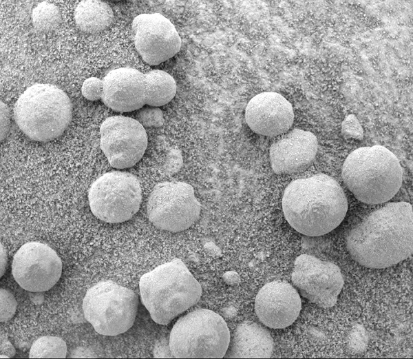
| 15:29, 20 December 2018 | Blueberries eagle.jpg (file) |  |
173 KB | Suitupandshowup | "Blueberries" (Hematite Spheres) at Eagle Crater on Mars. Microscopic Imager Non-linearized Full frame EDR acquired on Sol 46 of Opportunity's mission to Meridiani Planum at approximately at approximately 11:35:50 Mars local solar time, Microscopic Ima... | 1 |
| 15:22, 20 December 2018 | Eagle crater on the Mars PIA05163.jpg (file) | 16 KB | Suitupandshowup | This high-resolution image captured by the Mars Exploration Rover Opportunity's panoramic camera highlights the puzzling rock outcropping that scientists are eagerly planning to investigate. Presently, Opportunity is on its lander facing northeast; the... | 1 | |
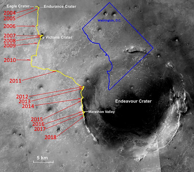
| 14:25, 20 December 2018 | Opportunity rover lifetime progress map.jpg (file) |  |
132 KB | Suitupandshowup | Yearly progress of opportunity rover with D.C. overlay for distance comparison. Date 18 February 2018 Source Own work Author James919 https://commons.wikimedia.org/wiki/File:Opportunity_rover_lifetime_progress_map.jpg Image credit: NASA/James919 | 1 |
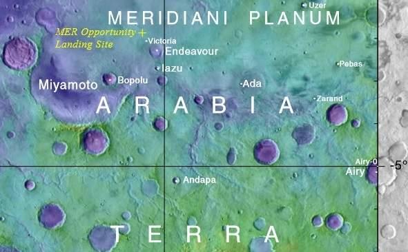
| 14:19, 20 December 2018 | Meridianicropped.png (file) |  |
510 KB | Suitupandshowup | Map showing the location of Opportunity's landing site and nearby features Source This file was derived from: Mapbeer.jpg https://commons.wikimedia.org/wiki/File:Meridianicropped.png Image credit: NASA | 1 |
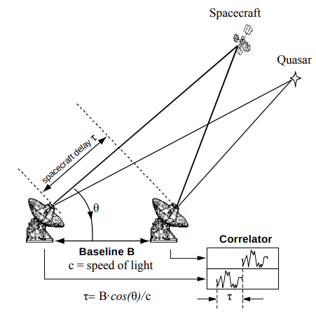
| 22:51, 19 December 2018 | CCSDS DDOR Observation Geometry.png (file) |  |
50 KB | Pb | Figure representing the geometry when performing Delta-DOR measurements for spacecraft navigation. Obtained from the CCSDS May 2013 Green Book, Delta-DOR Technical Characteristics and Performance. Available here: https://public.ccsds.org/Pubs/500x1g1.pdf | 1 |
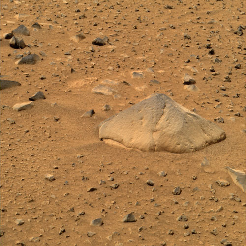
| 17:34, 18 December 2018 | AdirondackP2542 Sol14 L456-A16R1 br.jpg (file) |  |
80 KB | Suitupandshowup | This approximate true color image taken by the panoramic camera onboard the Mars Exploration Rover Spirit shows "Adirondack," the rover's first target rock. Spirit traversed the sandy martian terrain at Gusev Crater to arrive in front of the football-s... | 1 |
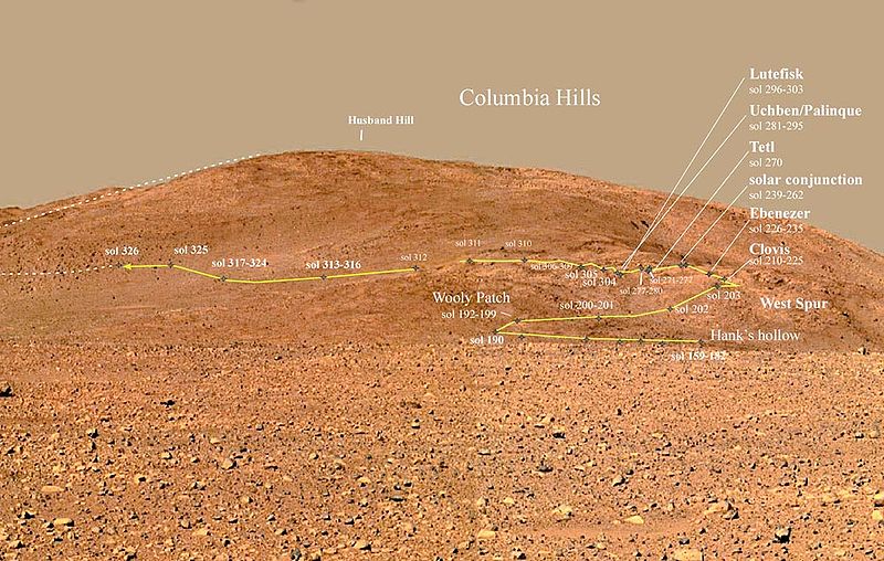
| 19:44, 17 December 2018 | Gusev - Colina Husbandlabeled.jpg (file) |  |
125 KB | Suitupandshowup | Columbia Hills - Gusev Crater Source: Source: http://www.jpl.nasa.gov/news/news.cfm?release License: http://www.jpl.nasa.gov/images/policy/ JPL Image Policy Unless otherwise noted, images and video on JPL public web sites (public sites ending with... | 1 |
| 19:38, 17 December 2018 | PIA05591 Spirit's Destination (panorama).jpg (file) | 56 KB | Suitupandshowup | This panoramic image mosaic from the Mars Exploration Rover Spirit panoramic camera, shows the rover's destination toward the hills nicknamed the "Columbia Hills," on the right. The rover's heatshield can be seen on the left as a tiny bright dot in the... | 1 | |
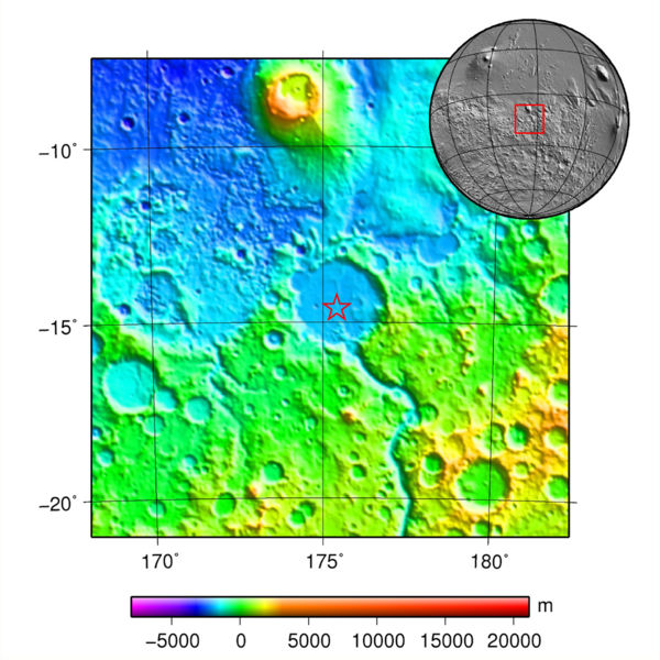
| 19:32, 17 December 2018 | MOLA spiritlandingmap.jpg (file) |  |
96 KB | Suitupandshowup | Map and globe showing Spirit's landing location. Colors relate to elevation. Source: plotted using GMT and gridded MOLA data archive meg0031t.grd https://commons.wikimedia.org/wiki/File:MOLA_spirit.jpg Author: Martin Paue | 1 |
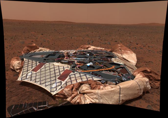
| 19:26, 17 December 2018 | PIA05117 modestspiritfolded.jpg (file) |  |
51 KB | Suitupandshowup | This image mosaic taken by the panoramic camera onboard the Mars Exploration Rover Spirit shows the rover's landing site, the Columbia Memorial Station, at Gusev Crater, Mars. This spectacular view may encapsulate Spirit's entire journey, from lander t... | 1 |
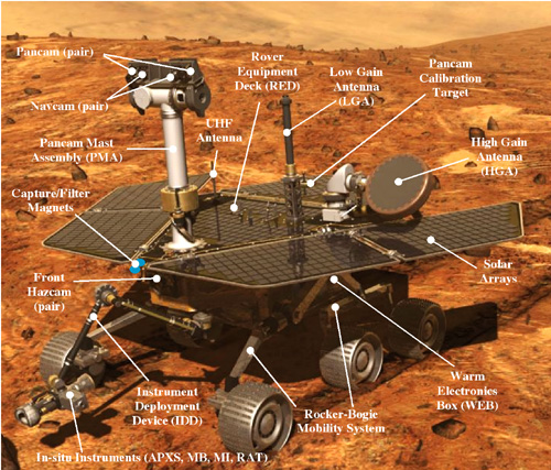
| 17:01, 17 December 2018 | Rover1 detail 500.jpg (file) |  |
154 KB | Suitupandshowup | Mars Rover with parts labeled Source: https://mars.jpl.nasa.gov/mer/mission/images/rover1_detail_500.jpg Image Credit: NASA/JPL | 1 |
| 16:13, 17 December 2018 | Internet Task Force.png (file) |  |
20 KB | Jburk | 1 | |
| 16:11, 17 December 2018 | James Burk.jpg (file) |  |
35 KB | Jburk | 1 | |
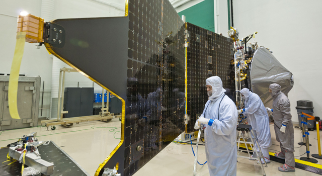
| 10:09, 17 December 2018 | Maven20130213-640solarpanels.jpg (file) |  |
199 KB | Suitupandshowup | MAVEN showing solar panel while in clean room at Lockheed Martin with technicians installed the orbiter's two solar panels. Courtesy Lockheed Martin Source: https://www.jpl.nasa.gov/news/news.php?feature=3690 | 1 |
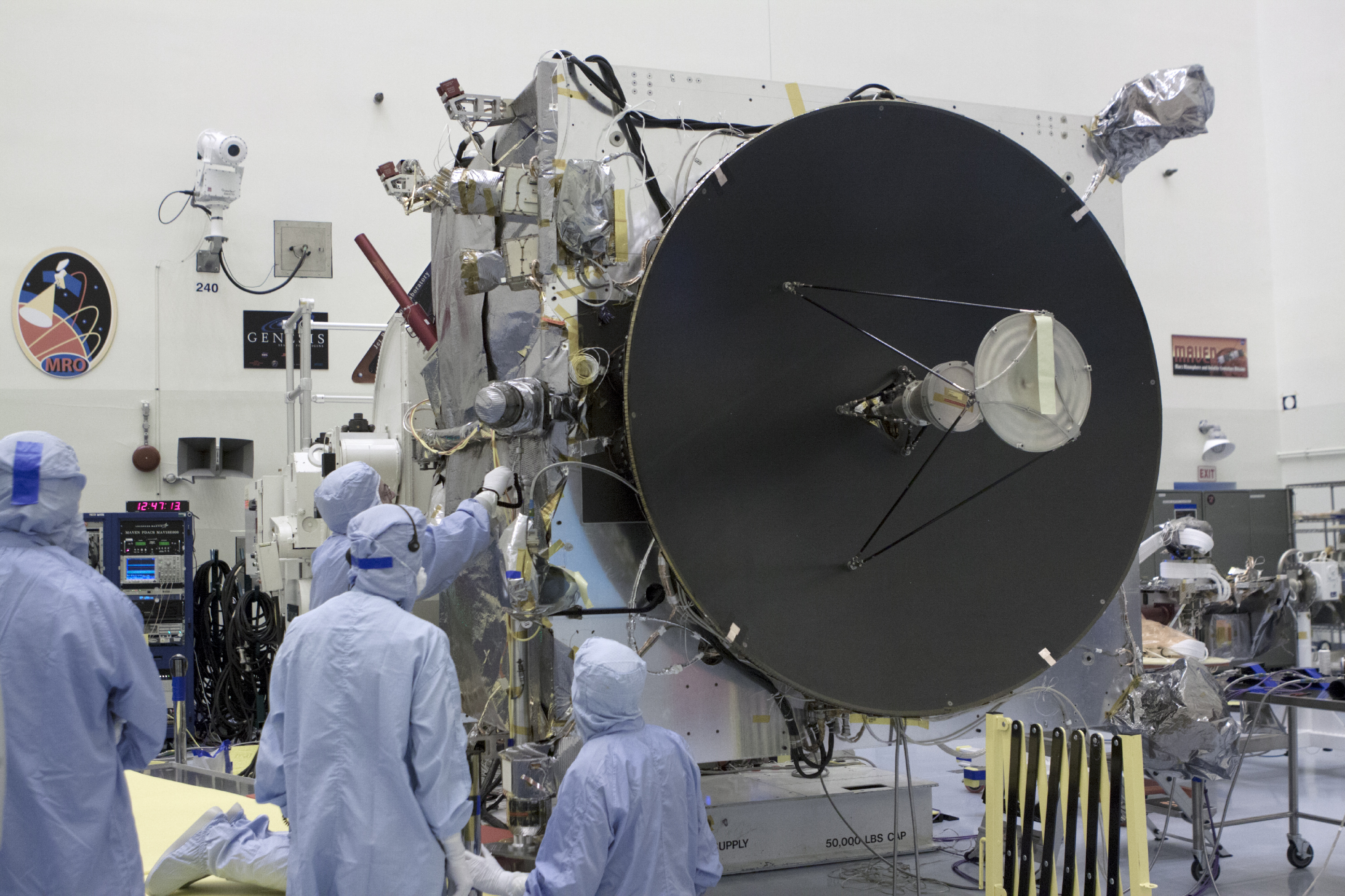
| 10:03, 17 December 2018 | Dsn-mavenhighgain.jpg (file) |  |
3.81 MB | Suitupandshowup | MAVEN in clean room showing high-gain antenna Source: https://www.nasa.gov/sites/default/files/dsn-mavenhighgain.jpg Image credit: NASA/Gov | 1 |
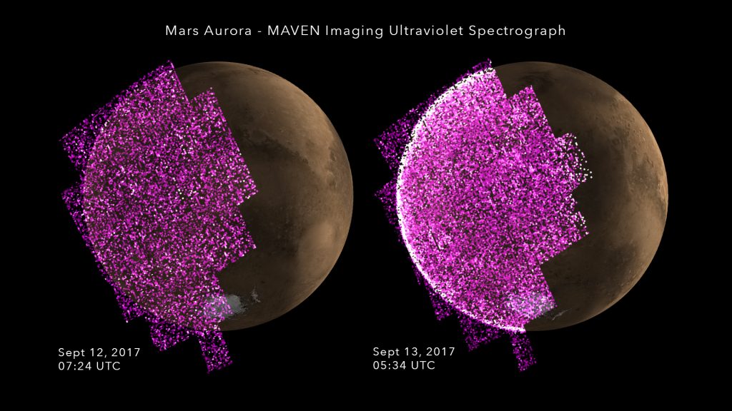
| 09:47, 17 December 2018 | MAVENAuroraBeforeDuring-1024x576.jpg (file) |  |
106 KB | Suitupandshowup | Aurora before and during solar storm arrival, as seen by MAVEN Source: http://lasp.colorado.edu/home/maven/solar-storm-triggers-whole-planet-aurora-at-mars/ Courtesy NASA/University of Colorado Boulder-LASP | 1 |
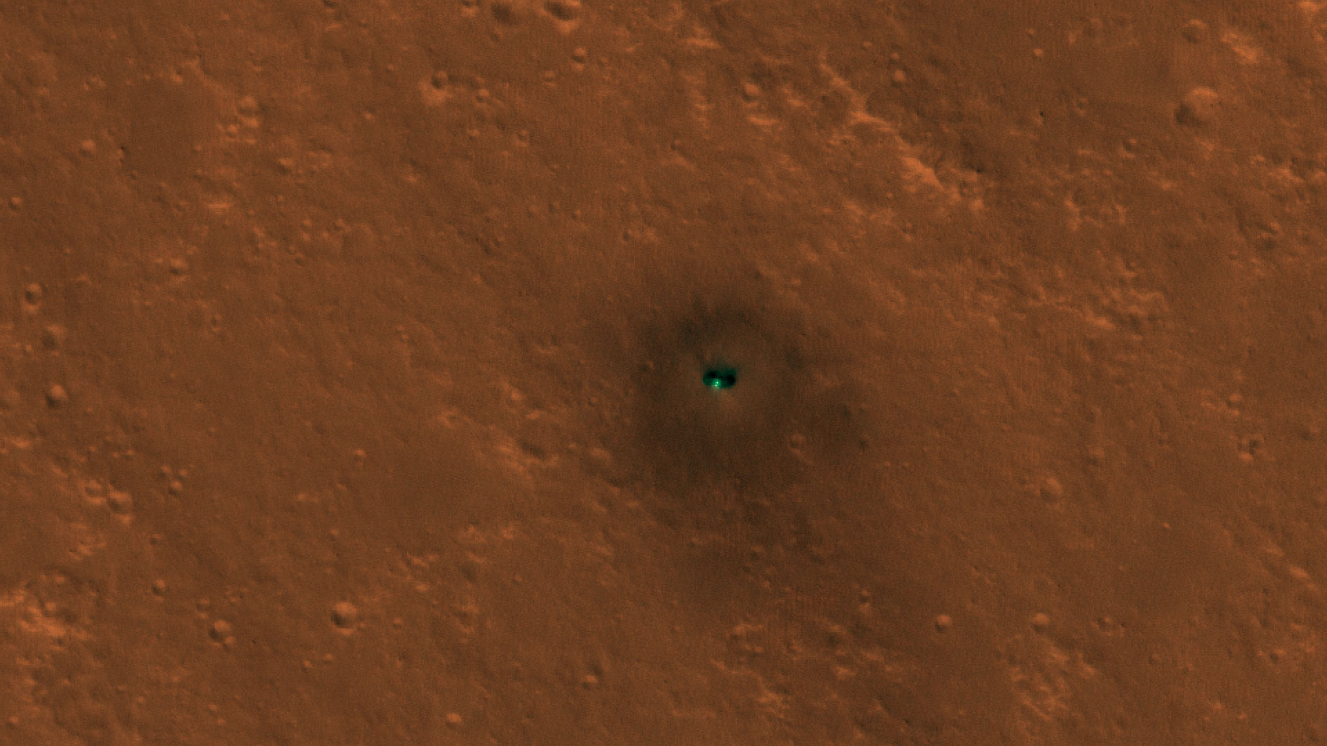
| 14:17, 15 December 2018 | ESP 058005 1845-lander-full-res.jpg (file) |  |
300 KB | Suitupandshowup | InSight on Mars, as seen by HiRISE Source: https://static.uahirise.org/images/2018/details/cut/ESP_058005_1845-lander-full-res.jpg Image credit: NASA/JPL/University of Arizona | 1 |
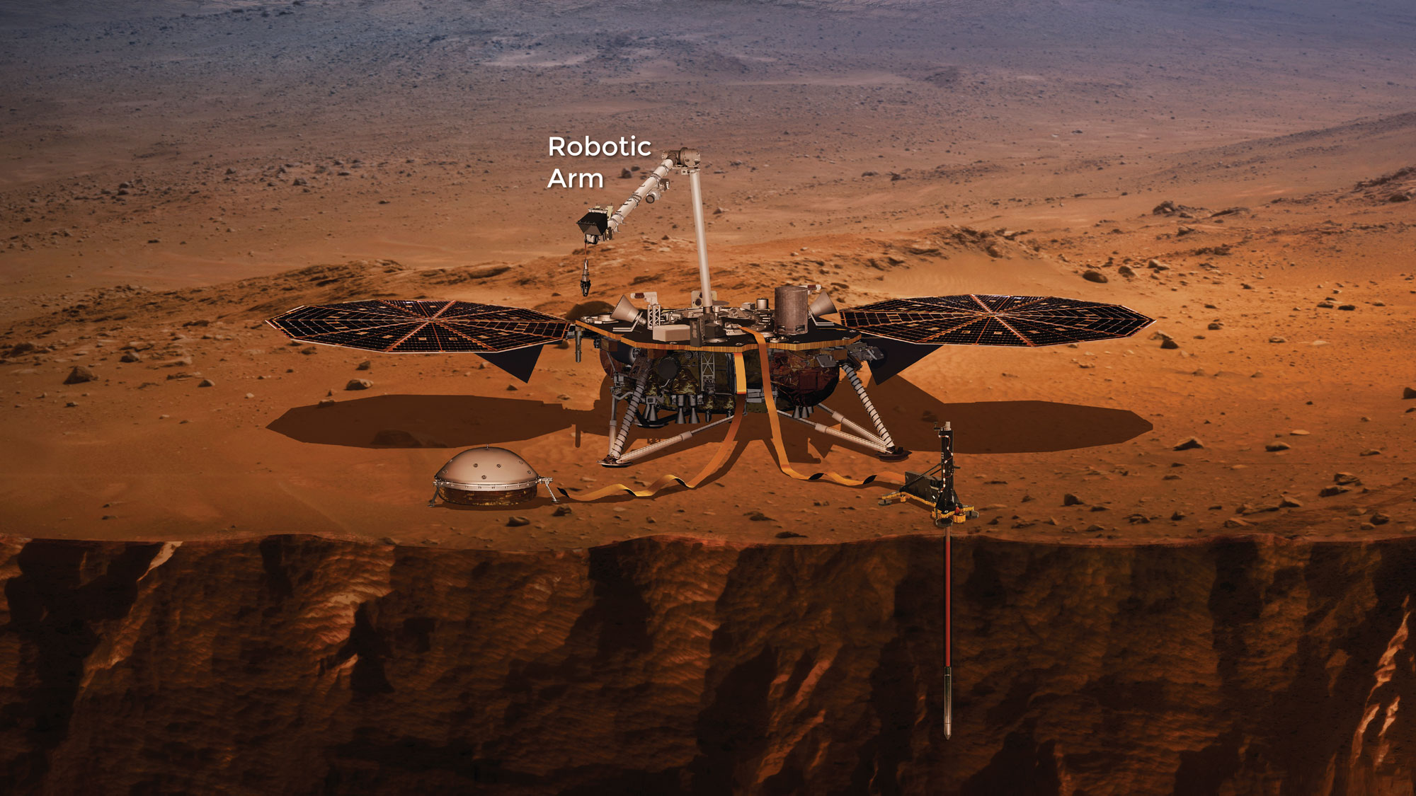
| 13:31, 15 December 2018 | Insightlander.jpg (file) |  |
405 KB | Suitupandshowup | InSight lander Source: https://mars.nasa.gov/insight/spacecraft/about-the-lander/ Image credit: NASA/JPL/ | 1 |
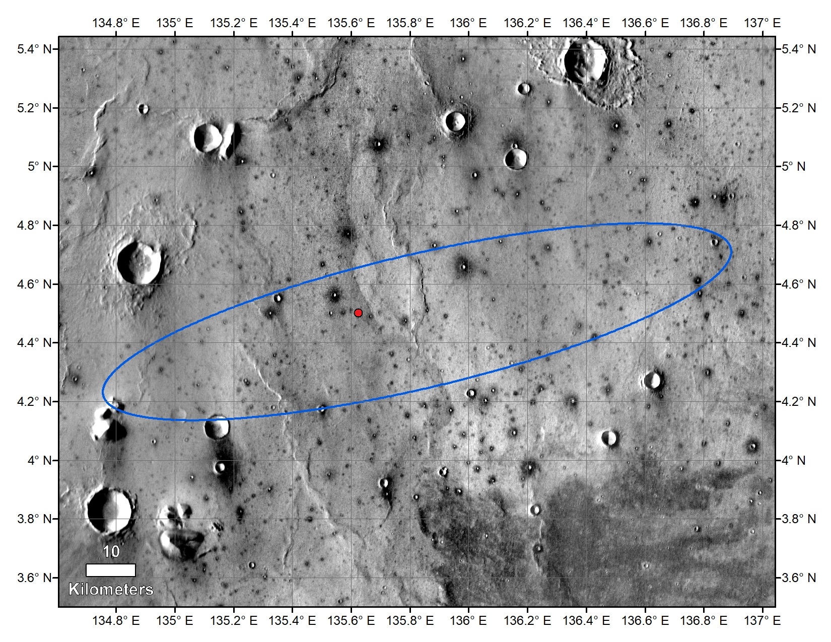
| 13:27, 15 December 2018 | PIA22878b-annotatedinsightlanding.jpg (file) |  |
874 KB | Suitupandshowup | Map showing location of Insight lander--indicated with red dot. Picture taken by the THEMIS camera on NASA's 2001 Mars Odyssey orbiter in 2015 Source: https://mars.nasa.gov/insight/resources/22222/insights-final-location-on-mars/ Image credit: NASA... | 1 |
| 18:44, 14 December 2018 | Vikikinglander2.jpg (file) |  |
492 KB | Suitupandshowup | Viking lander Source: https://www.jpl.nasa.gov/missions/web/viking.jpg Image credit: NASA/JPL | 1 |
| 17:37, 14 December 2018 | Vikinglander2-1viking2.jpg (file) |  |
844 KB | Suitupandshowup | View of surface around Viking 2 Source: https://nssdc.gsfc.nasa.gov/image/planetary/mars/vikinglander2-1.jpg Image Credit: NASA/GSFC/NSSDC | 1 |
| 17:28, 14 December 2018 | Mars landsite globe.jpg (file) |  |
139 KB | Suitupandshowup | Map of Mars showing landing sites of Vikings and pathfinder. Source: https://nssdc.gsfc.nasa.gov/planetary/image/mars_landsite_globe.gif Image credit: NASA/GSFC/NSSDC | 1 |
| 15:59, 14 December 2018 | Viking orbiter.jpg (file) |  |
15 KB | Suitupandshowup | Viking as it traveled to Mars with orbiter at the top and lander inside the egg-shaped aeoshell at the bottom. Source: https://nssdc.gsfc.nasa.gov/photo_gallery/photogallery-spacecraft.html#viking Image credit: NASA | 1 |
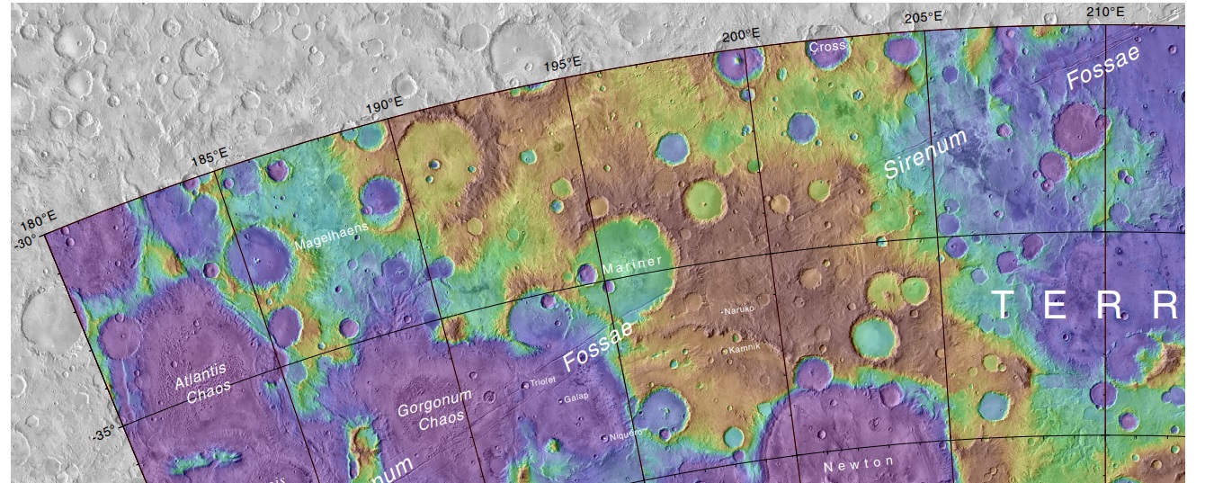
| 07:51, 7 December 2018 | Marinercratermap.jpg (file) |  |
375 KB | Suitupandshowup | Map showing Mariner Crater and other nearby features. Mariner Crater was named after the Mariner 4 spacecraft which first imaged the crater. Source: https://planetarynames.wr.usgs.gov/images/mc24_2014.pdf Image Credit: NASA/USGS | 1 |
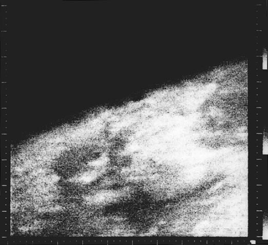
| 16:28, 5 December 2018 | Mars (Mariner 4)first image.jpg (file) | first_image.jpg) |
48 KB | Suitupandshowup | Mariner 4 image, the first close-up image ever taken of Mars. This shows an area about 330 km across by 1200 km from limb to bottom of frame, centered at 37 N, 187 W. The area is near the boundary of Elysium Planitia to the west and Arcadia Planitia to... | 1 |
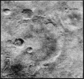
| 13:27, 5 December 2018 | Mariner 4 craters.jpg (file) |  |
37 KB | Suitupandshowup | Mars craters, as seen by mariner 4 Image credit: NASA | 1 |
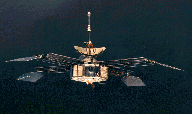
| 13:22, 5 December 2018 | Mariner 3 and 4.jpg (file) |  |
299 KB | Suitupandshowup | Mariner 3 and 4 The two craft were identical. Source: http://solarsystem.nasa.gov/multimedia/display.cfm?IM_ID=1897 http://nssdc.gsfc.nasa.gov/image/spacecraft/mariner04.gif. Image credit: NASA | 1 |
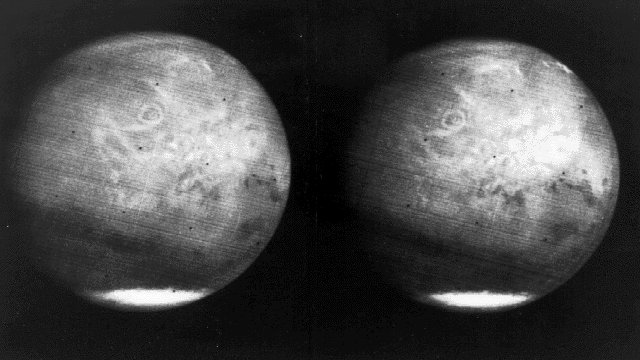
| 11:33, 30 November 2018 | Mars full disk approach view from Mariner 7.jpg (file) |  |
65 KB | Suitupandshowup | (1969) View of the entire planet of Mars from Mariner 7, showing NIX Olympia (later identified as the giant shield volcano Olympus Mons), and polar caps. Photographed from 200,000 miles away. Mariner 7 was launched on March 27, 1969 and arrived on Au... | 1 |


.jpg)