File:ESP 047940 2190channelnetwork.jpg
Revision as of 09:57, 22 January 2019 by Suitupandshowup (talk | contribs) (Close-up of gullies, as seen by hirise under HiWish program. Location is 55.8 N and 208.1 E. Date 5/7/12 Source http://hirise.lpl.arizona.edu/ESP_026420_2360 Image credit: NASA/JPL/University of Arizona/Secosky)
Error creating thumbnail: Unable to save thumbnail to destination
No higher resolution available.
ESP_047940_2190channelnetwork.jpg (277 × 600 pixels, file size: 43 KB, MIME type: image/jpeg)
Summary
Close-up of gullies, as seen by hirise under HiWish program. Location is 55.8 N and 208.1 E. Date 5/7/12 Source http://hirise.lpl.arizona.edu/ESP_026420_2360
Image credit: NASA/JPL/University of Arizona/Secosky
Licensing
Public domain images are available for anybody to use without any licenses, royalties, or special permissions.
File history
Click on a date/time to view the file as it appeared at that time.
| Date/Time | Thumbnail | Dimensions | User | Comment | |
|---|---|---|---|---|---|
| current | 09:57, 22 January 2019 | 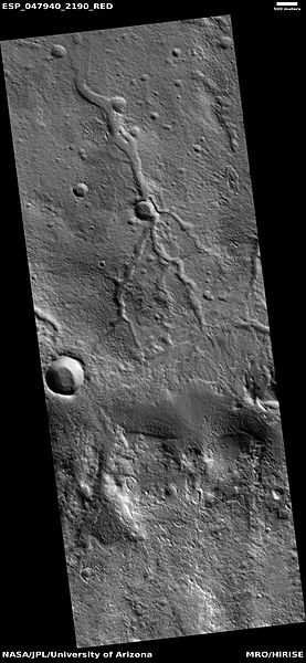 | 277 × 600 (43 KB) | Suitupandshowup (talk | contribs) | Close-up of gullies, as seen by hirise under HiWish program. Location is 55.8 N and 208.1 E. Date 5/7/12 Source http://hirise.lpl.arizona.edu/ESP_026420_2360 Image credit: NASA/JPL/University of Arizona/Secosky |
You cannot overwrite this file.
File usage
The following page uses this file:


