Uploads by Suitupandshowup
This special page shows all uploaded files.
| Date | Name | Thumbnail | Size | Description | Versions |
|---|---|---|---|---|---|
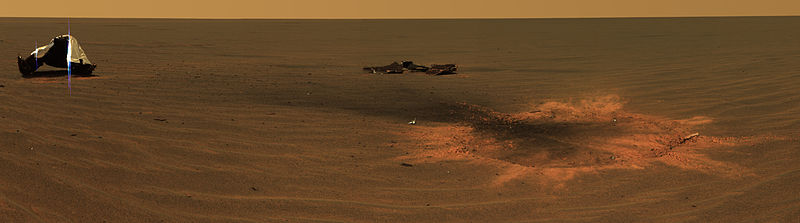
| 08:22, 29 March 2018 | Opportunity Heat Shield.jpg (file) |  |
28 KB | This stunning image features the heat shield impact site of NASA's Mars Exploration Rover Opportunity. This is an approximately true-color mosaic of panoramic camera images taken through the camera's 750-, 530-, and 430-nanometer filters. The mosaic w... | 1 |
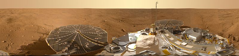
| 08:06, 29 March 2018 | PIA13804-MarsPhoenixLander-Panorama-20080525b.jpg (file) | 36 KB | Mars Panorama of Phoenix Landing Site and Lander Deck The full-circle panorama in approximately true color shows the polygonal patterning of ground at the landing area, similar to patterns in permafrost areas on Earth. The center of the image is the... | 1 | |
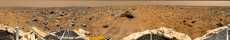
| 07:50, 29 March 2018 | Mars pathfinder panorama large.jpg (file) | 61 KB | Panoramic image from Mars Pathfinder mission Picture Credit: NASA | 1 | |
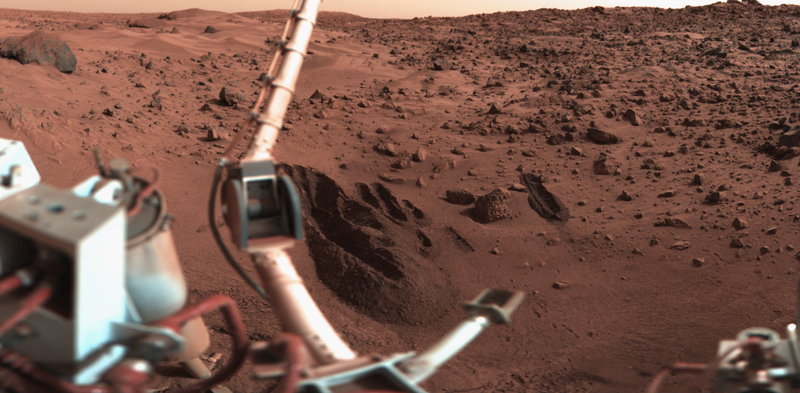
| 07:40, 29 March 2018 | Mars Viking 11d128.png (file) |  |
544 KB | Original Caption Released with NASA image: The Viking 1 Lander sampling arm created a number of deep trenches as part of the surface composition and biology experiments on Mars. The digging tool on the sampling arm (at lower center) could scoop up samp... | 1 |
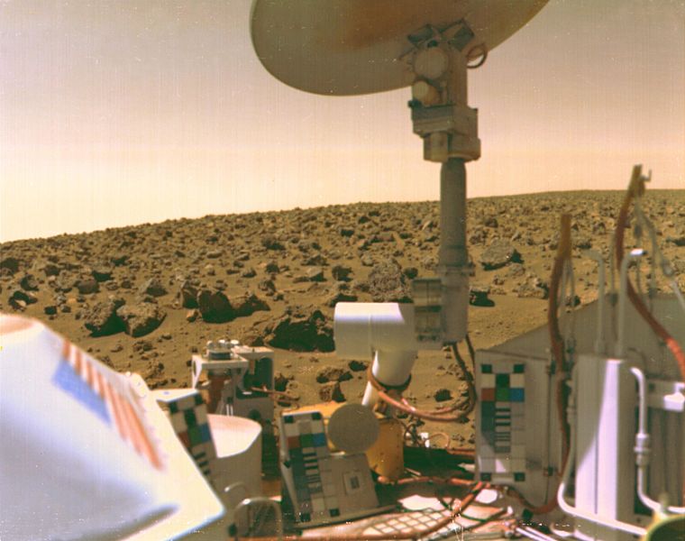
| 07:35, 29 March 2018 | Viking2lander1.jpg (file) |  |
66 KB | A boulder-strewn field of red rocks stretches across the horizon in this self-portrait of Viking 2 on Mars' Utopian Plain. Fine particles of red dust have settled on spacecraft's surfaces. The same dust is responsible for Mars' salmon-colored sky as th... | 1 |
| 06:33, 29 March 2018 | ESP 039753 1385gulliespits.jpg (file) |  |
68 KB | Group of gullies with scale Source: http://hirise.lpl.arizona.edu/ESP_036753_1385 Image credit: NASA/JPL/University of Arizona | 1 |
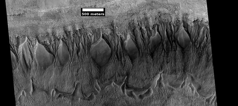
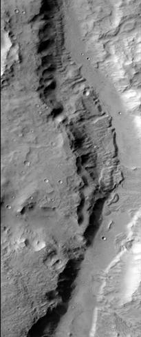
| 08:03, 28 March 2018 | ESP 036995 1410tonguewide.jpg (file) |  |
2.86 MB | Tongue-shaped glacier Source: http://hirise.lpl.arizona/edu/ESP_036995_1410 Image credit: NASA/JPL/University of Arizona | 1 |
| 07:57, 28 March 2018 | Wikiconcentricclose22451.jpg (file) |  |
80 KB | Close-up of concentric crater fill, as seen by HiRISE under HiWish program. Source: http://hirise.lpl.arizona.edu/ESP_022451_1350 Image credit: NASA/JPL/University of Arizona | 1 |
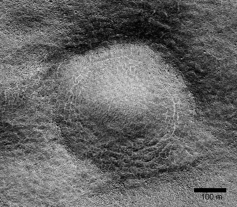
| 07:51, 28 March 2018 | Wikiconcentric.jpg (file) |  |
97 KB | Concentric crater, as seen by ctx--same place as hirise esp_022451_1350 Source: http://viewer.mars.asu.edu/planetview/inst/ctx/B16_016003_1347_XN_45S140W#P=B16_016003_1347_XN_45S140W&T=2 Image credit: NASA/MSS | 1 |
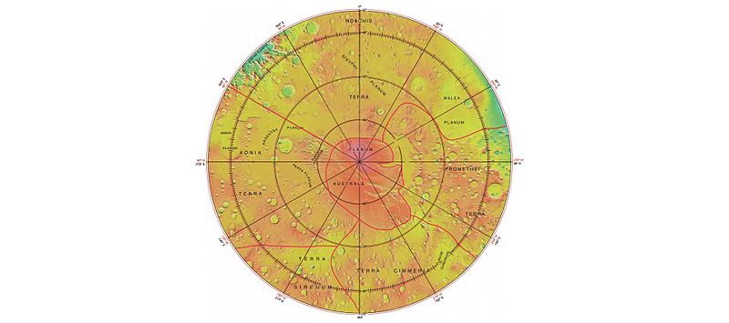
| 07:43, 28 March 2018 | Wikimolasouthpole.jpg (file) |  |
36 KB | MOLA map showing boundaries around south pole of Mars Source: http://planetarynames.wr.usgs.gov/images/mola_regional_boundaries.pdf Image credit: NASA/International Astronomical Union Working Group for Planetary System Nomenclature. "Gazetteer of Pla... | 1 |
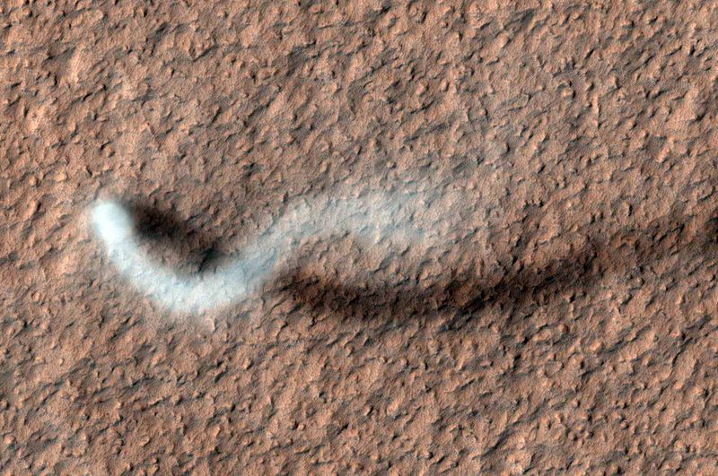
| 08:59, 19 March 2018 | The Serpent Dust Devil on Mars PIA15116.jpg (file) |  |
132 KB | A towering dust devil casts a serpentine shadow over the Martian surface in this image acquired by the High Resolution Imaging Science Experiment (HiRISE) camera on NASA's Mars Reconnaissance Orbiter. The devil is 800m in height and 30m wide. Source:... | 1 |
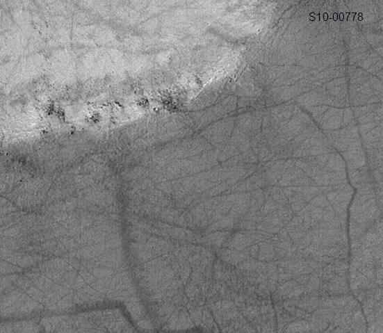
| 08:49, 19 March 2018 | Dust devil tracks in Eridania.jpg (file) |  |
45 KB | Dust devil tracks in Eridania. This image was taken with the Mars Orbital Camera MOC) on the Mars Global Surveyor MGS). It's id number is S10-00778, and its location is 196.63 degrees west longitude and 55.11 degrees south latitude. The photo credit... | 1 |
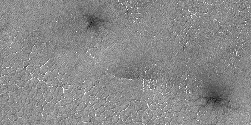
| 08:19, 19 March 2018 | 48845 1010spiders.jpg (file) |  |
83 KB | Spiders, as seen by HiRISE under HiWish program Source: http://hirise.lpl.arizona.edu/48845_1010 Image credit: NASA/JPL/University of Arizona/Secosky | 1 |
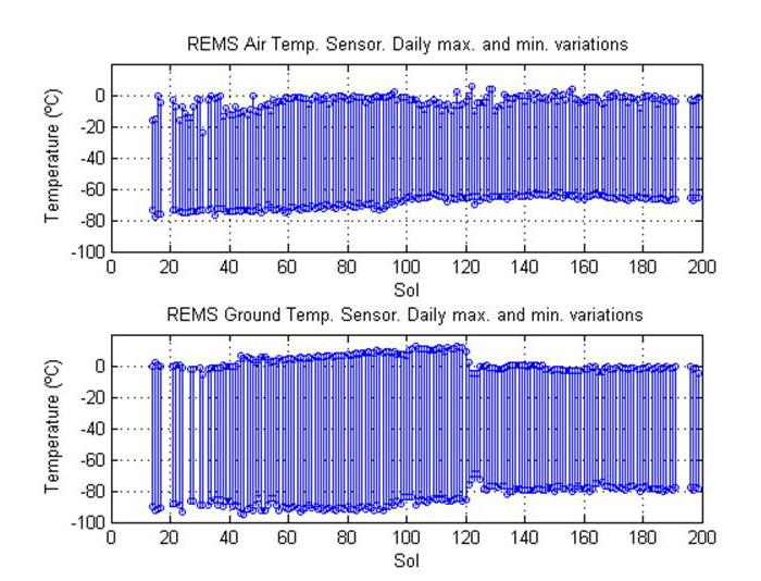
| 06:23, 19 March 2018 | PIA16913-MarsCuriosityRover-SteadyTemperature-GaleCrater.jpg (file) |  |
74 KB | This pair of graphs shows about one-fourth of a Martian year's record of temperatures (in degrees Celsius) measured by the Rover Environmental Monitoring Station (REMS) on NASA's Curiosity rover. The data are graphed by sol number (Martian day, startin... | 1 |
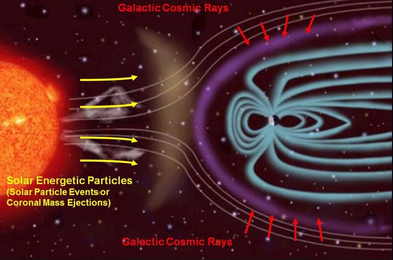
| 06:14, 19 March 2018 | PIA16938-RadiationSources-InterplanetarySpace.jpg (file) |  |
77 KB | PIA16938: Sources of Ionizing Radiation in Interplanetary Space Galactic cosmic rays are a variable shower of charged particles coming from supernova explosions and other events extremely far from our solar system. The sun is the other main source of... | 1 |
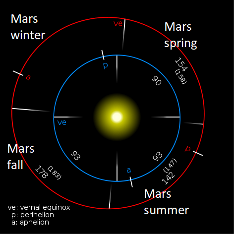
| 13:16, 17 March 2018 | Mars earth orbitlabeled.png (file) |  |
43 KB | Diagram comparing the orbits and seasons of Mars and the Earth The vernal equinox is the first day of spring. The lengths of the seasons for Mars are given in both Earth days and Mars days (called sols). For example the diagram shows 142 Mars days... | 1 |
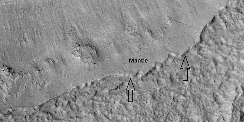
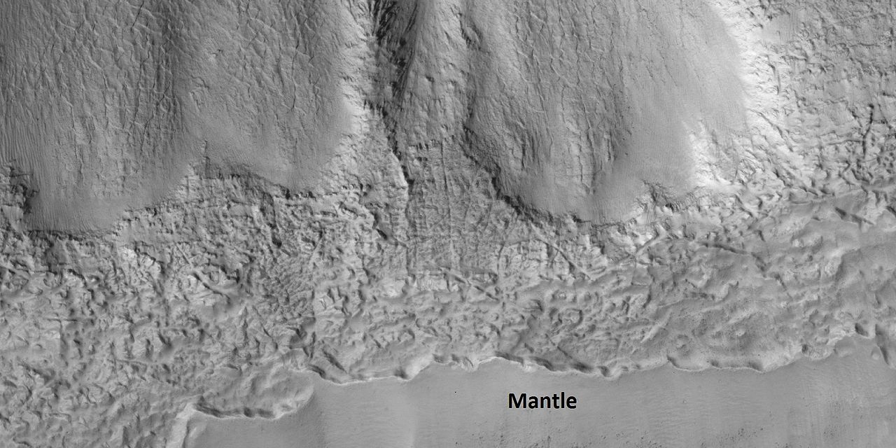
| 08:50, 17 March 2018 | 48063 1395mantle.jpg (file) |  |
69 KB | Mantle in Hellas quadrangle, as seen by HiRISE under HiWish program Arrows show thickness of mantle. Source: http://hirise.lpl.arizona.edu/ESP_048063_1395 Image credit: NASA/JPL/University of Arizona/Secosky | 1 |
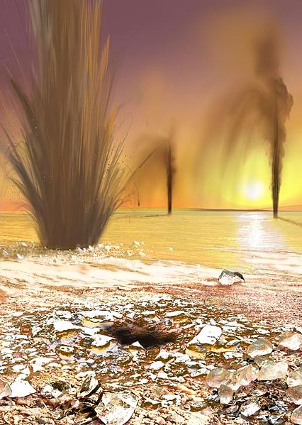
| 08:39, 17 March 2018 | Geysers on Mars.jpg (file) |  |
66 KB | Artist concept showing sand-laden jets (Geysers on Mars) shoot into the Martian polar sky. Image credit: Arizona State University/Ron Miller Source: NASA's Jet Propulsion Laboratory: http://www.jpl.nasa.gov/news/news.cfm?release=2006-100 | 1 |
| 08:16, 17 March 2018 | MarsDustDevi-AmazonisPlanitia-MGS-MOC-20010401-E03-00938.gif (file) |  |
154 KB | One objective for the Mars Global Surveyor (MGS) Mars Orbiter Camera (MOC) in the Extended Mission is to continue looking for changes and dynamic events taking place on the red planet. The feature shown here elicited gasps of exitement among the MOC Op... | 1 |
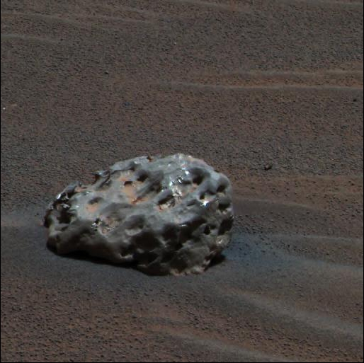
| 08:01, 17 March 2018 | Meteoritemars.jpg (file) |  |
152 KB | Iron meteorite found on Mars by a rover Image credit: NASA | 1 |
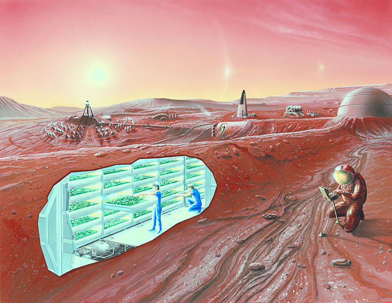
| 08:37, 16 March 2018 | Concept Mars colony-underground.jpg (file) |  |
144 KB | Artist impression of a Mars settlement with cutaway view, including underground greenhouse Image credit: NASA Ames Research Center - NASA Ames featured images | 1 |
| 08:32, 16 March 2018 | Mars Greenhouse.jpg (file) |  |
105 KB | A conceptual rendering of a greenhouse on the surface of Mars. Image credit: NASA/Human Systems Engineering and Development Division | 1 |
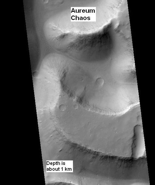
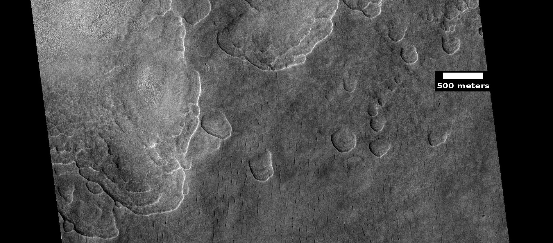
| 10:20, 15 March 2018 | Aureum Chaos wide view.jpg (file) |  |
28 KB | Wide view of Aureum Chaos, one of first 8 images released in public suggestion program. Location is 2.438 S and 332.144 E. Source: http://hirise.lpl.arizona.edu/ESP_016869_1775 Image credit: NASA/JPL/University of Arizona/Secosky | 1 |
| 10:16, 15 March 2018 | 24807whitebuttei.jpg (file) |  |
75 KB | White butte in Margartifer Sinus quadrangle, as seen by HiRISE under HiWish program Box shows size of a football field. Source: http:hirise.lpl.arizona.edu/ESP_024807_1755 Picture credit: NASA/JPL/University of Arizona/Secosky | 1 |
| 10:11, 15 March 2018 | Wikimolaargyre.jpg (file) |  |
107 KB | MOLA map showing boundaries in southern hemisphere of Mars Source: http://planetarynames.wr.usgs.gov/images/mola_regional_boundaries.pdf Picture credit: NASA/Astronomical Union Working Group for Planetary System Nomenclature. "Gazetteer of Planetar... | 1 |
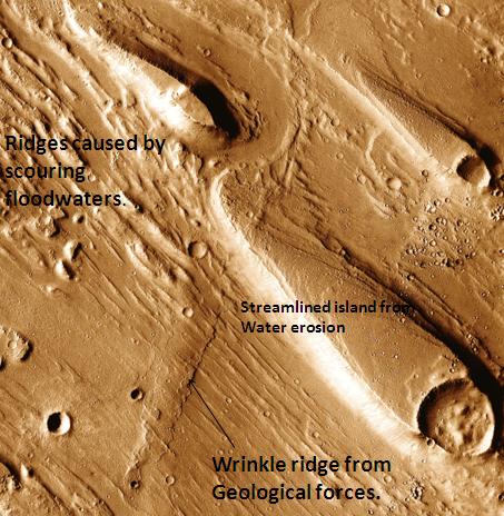
| 09:22, 9 March 2018 | Erosion features in Ares Vallis.jpg (file) |  |
59 KB | Erosion features in Ares Vallis, as seen by themis. Location is 15.9 degrees north latitude and 30 degrees west longitude. Picture taken with Mars Odyssey's THEMIS. http://themis.asu.edu/features/aresvallis Photo credit NASA/JPL/ASU. | 1 |
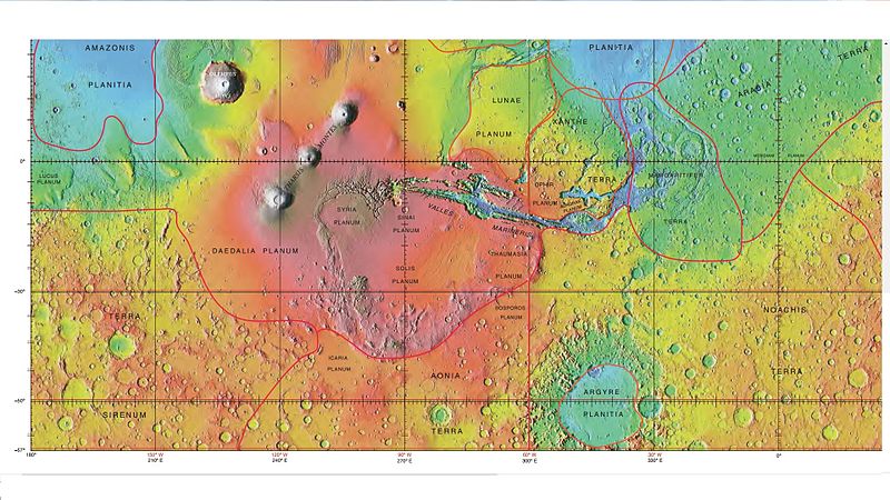
| 09:16, 9 March 2018 | Wikichaosmap.jpg (file) |  |
113 KB | Modified map showing Ares Vallis and other nearby features including many chaos regions Source: http://planetarynames.wr.usgs.gov/images/mc11_mola.pdf Image credit: Image courtesy NASA/USGS/Secosky | 1 |
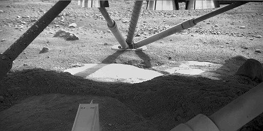
| 09:25, 1 March 2018 | PIA10741 Possible Ice Below Phoenix.jpg (file) |  |
33 KB | View under Phoenix spacecraft showing ice that was uncovered by blast from landing rockets. The Robotic Arm Camera on NASA's Phoenix Mars Lander captured this image underneath the lander on the fifth Martian day, or sol, of the mission. Descent thruste... | 1 |
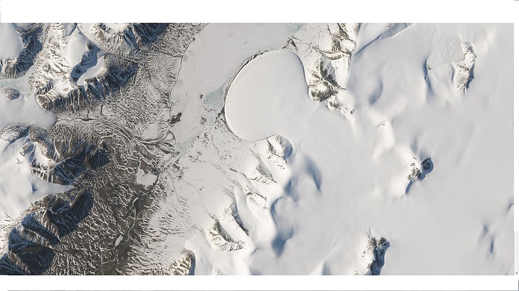
| 09:14, 1 March 2018 | Wikielephantglacier.jpg (file) |  |
113 KB | Elephant Foot Glacier at Romer Lake, Northeast Greenland Centered at 80.9° N, 19.5° W, acquired by Landsat 8. Source: http://eoimages.gsfc.nasa.gov/images/imagerecords/85000/85303/elephantfoot_oli_2014172_lrg.jpg Image credit: NASA | 1 |
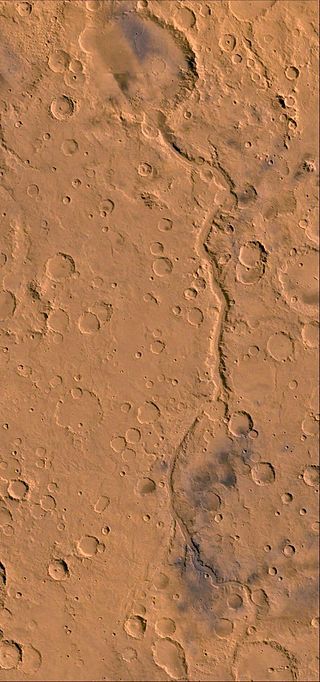
| 08:39, 1 March 2018 | Gusev - Ma'adim Vallis.jpg (file) |  |
56 KB | Ma'adim Vallis Source: http://www.jpl.nasa.gov/news/features.cfm?feature=527 Image credit: NASA | 1 |
| 08:36, 1 March 2018 | Maadim Vallis.jpg (file) |  |
19 KB | Ma'adim Vallis as seen by HiRISE. The location is 20.58 degrees south latitude and 182.58 degrees west longitude. Picture was taken with the Mars Reconnaissance Orbiter's HiRISE. Source:http://globaldata.mars.asu.edu/ctx/P02_001922_1595_XN_20S182W... | 1 |
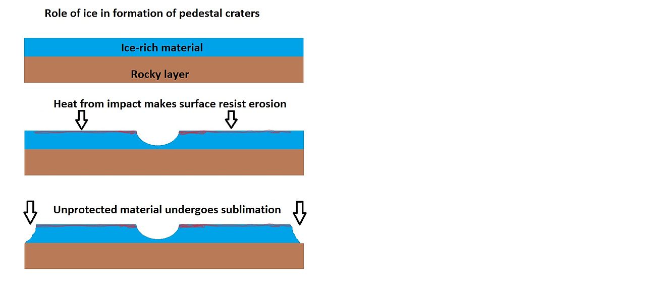
| 16:42, 28 February 2018 | Pedestaldrawingcolor2.jpg (file) |  |
39 KB | Drawing showing one way a pedestal crater could form Image credit: Jim Secosky | 1 |
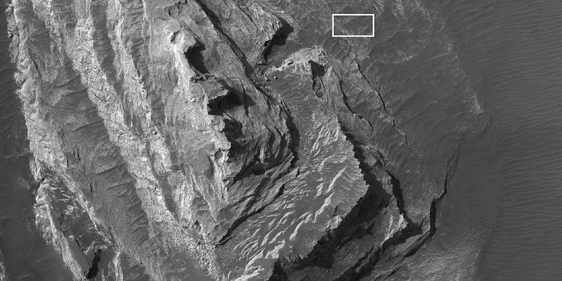
| 16:22, 28 February 2018 | 46622 1365ctxcontextccf.jpg (file) |  |
464 KB | Context view of hirise image 46622_1365, as seen by CTX Concentric crater fill Source: http://viewer.mars.asu.edu/planetview/inst/ctx/G15_023941_1374_XN_42S140W#P=G15_023941_1374_XN_42S140W&T=2 Image credit: NASA/MSS | 1 |
| 14:21, 28 February 2018 | ESP 037461 2255scallopstop.jpg (file) |  |
648 KB | Scalloped ground as seen by hirise under HiWish program Source: http://hirise.lpl.arizona.edu/ESP_037461_2255 Image credit: NASA/JPL/University of Arizona | 1 |
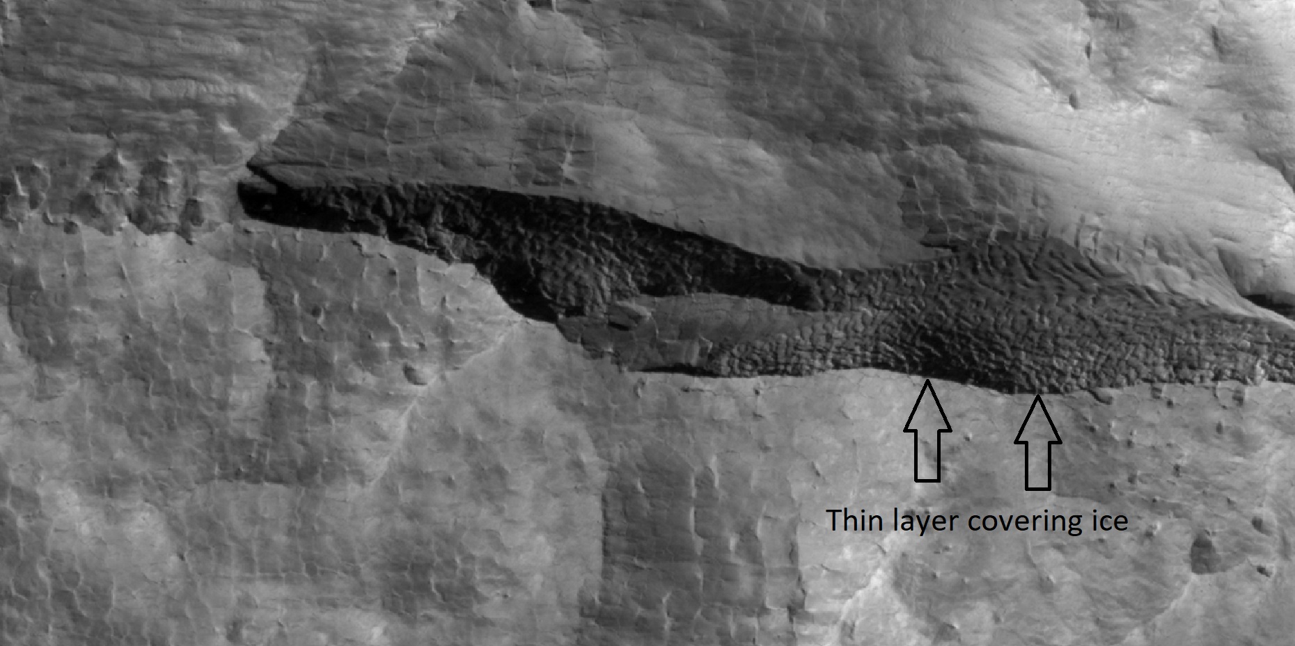
| 14:15, 28 February 2018 | 45290 2350icelayerscloseer.jpg (file) |  |
404 KB | Close view of depression that contains layers of ice under only 1-2 meters of covering debris, as seen by HiRISE under HiWish program Location is the Diacria quadrangle. Arrows indicate thin covering over ice layers. Source: http://hirise.lpl.arizona.... | 1 |
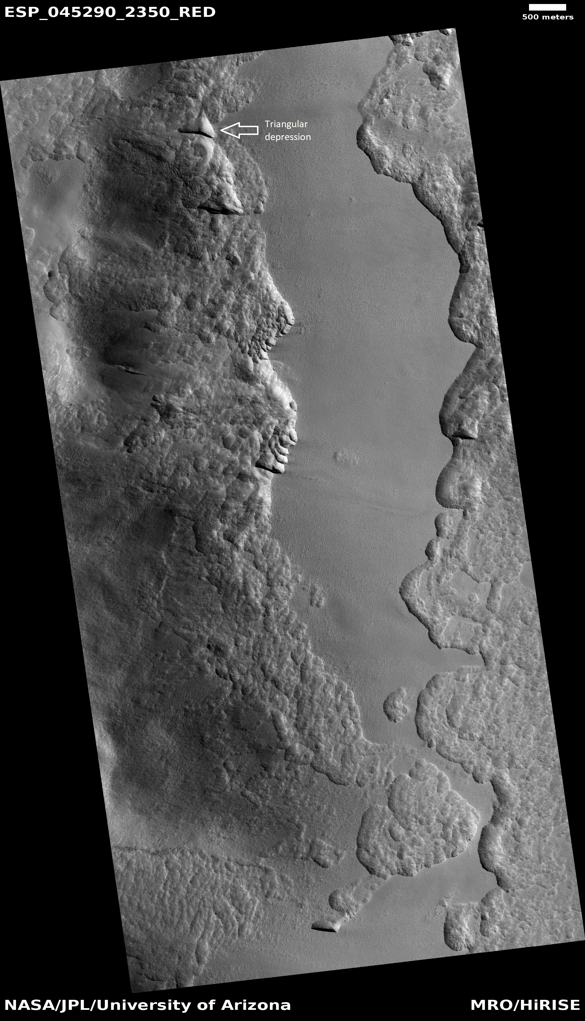
| 14:02, 28 February 2018 | ESP 045290 2350triangulardepression.jpg (file) |  |
2.07 MB | Triangular depression that is associated with ice under a thin cover of debris. Image from HiRISE under HiWish program Image credit: http://hirise.lpl.arizona.edu/ESP_045290_2350 | 1 |
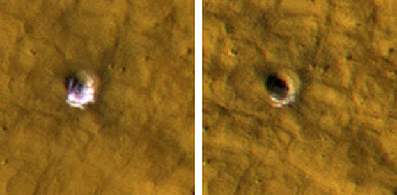
| 12:46, 27 February 2018 | Iceincraterscomparison.jpg (file) |  |
77 KB | Ice in craters, as seen by HiRISE Picture on left shows ice exposed in small crater. In the later picture on right most of the ice is gone. Picture is from ESP_011574_2235 in the Cebrenia quadrangle. Source: https://www.nasa.gov/mission_pages/MRO... | 1 |
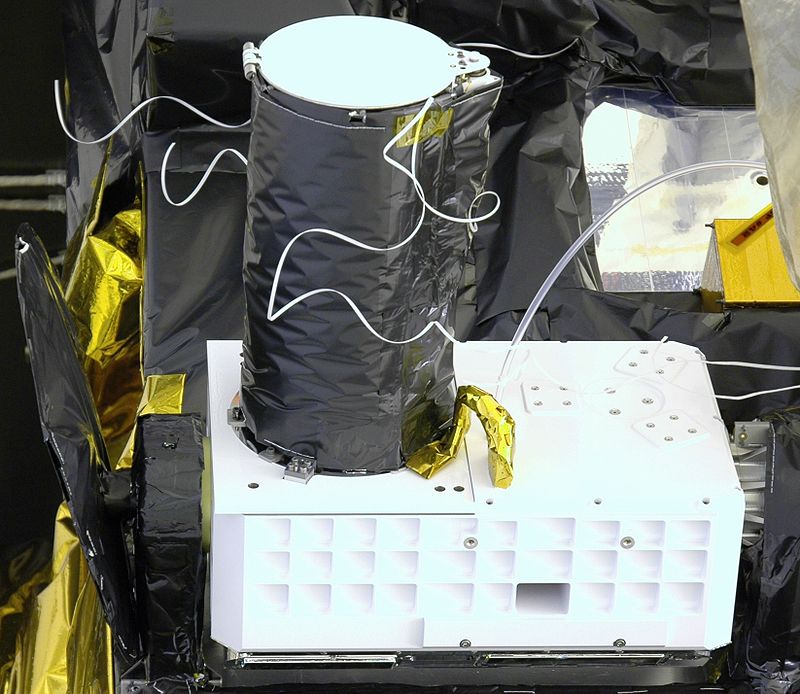
| 12:40, 27 February 2018 | MRO CRISM prelaunch 2.jpg (file) |  |
98 KB | CRISM, the first visible-infrared spectrometer to fly on a NASA Mars mission, will look for the residue of minerals that form in the presence of water – the “fingerprints” left by evaporated hot springs, thermal vents, lakes or ponds. Source:... | 1 |
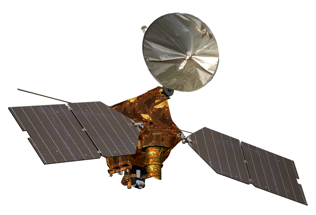
| 12:36, 27 February 2018 | Mars Reconnaissance Orbiter spacecraft model.png (file) |  |
491 KB | Artist's rendering, from NASA, of the Mars Reconnaissance Orbiter spacecraft, in mission configuration. The spacecraft spent its prime mission in orbit around Mars, with its main objectives concerning more detailed and specialised studies of the planet... | 1 |
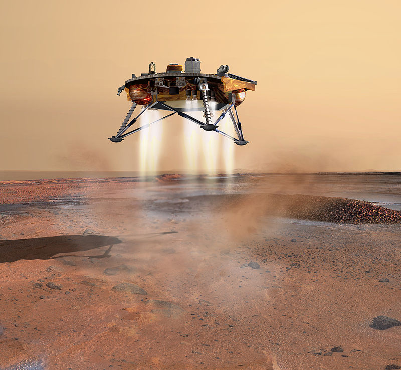
| 12:31, 27 February 2018 | Phoenix landing.jpg (file) |  |
112 KB | An artist's rendition of the Phoenix Mars probe during landing. The sophisticated landing system on Phoenix allows the spacecraft to touch down within 10 kilometres (6.2 mi) of the targeted landing area. Thrusters are started when the lander is 570 met... | 1 |
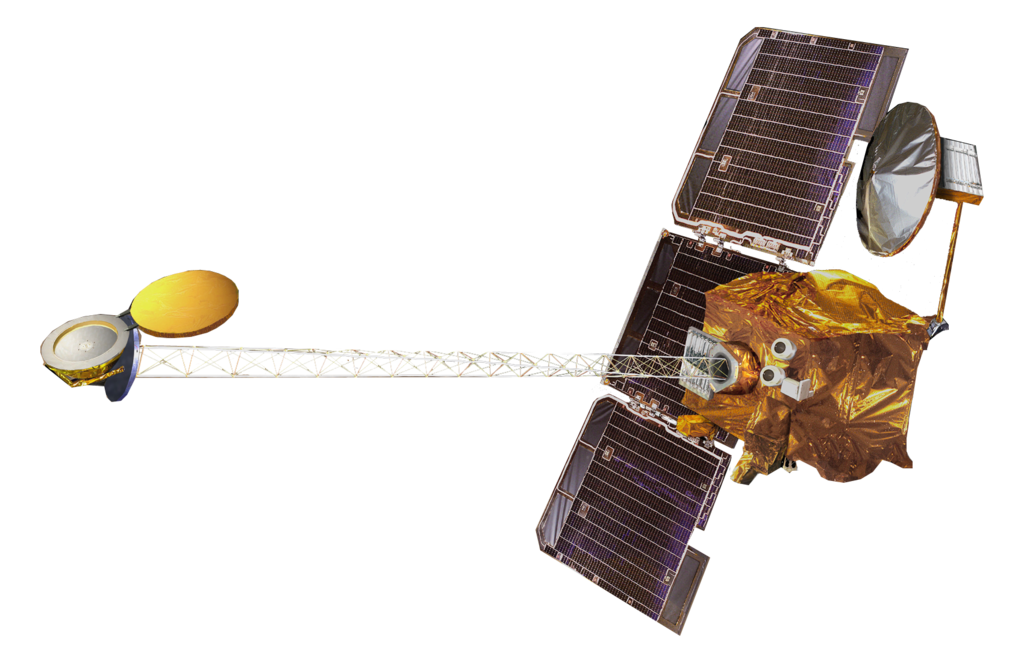
| 12:26, 27 February 2018 | Mars Odyssey spacecraft model.png (file) |  |
464 KB | Artist's view of Mars Odyssey spacecraft Mars Odyssey mapped distribution of water on Mars Source: Published source': "Spacecraft Icons" at NASA Science Direct source: Image hosted by smd-prod.s3.amazonaws.com. Image credit: NASA | 1 |
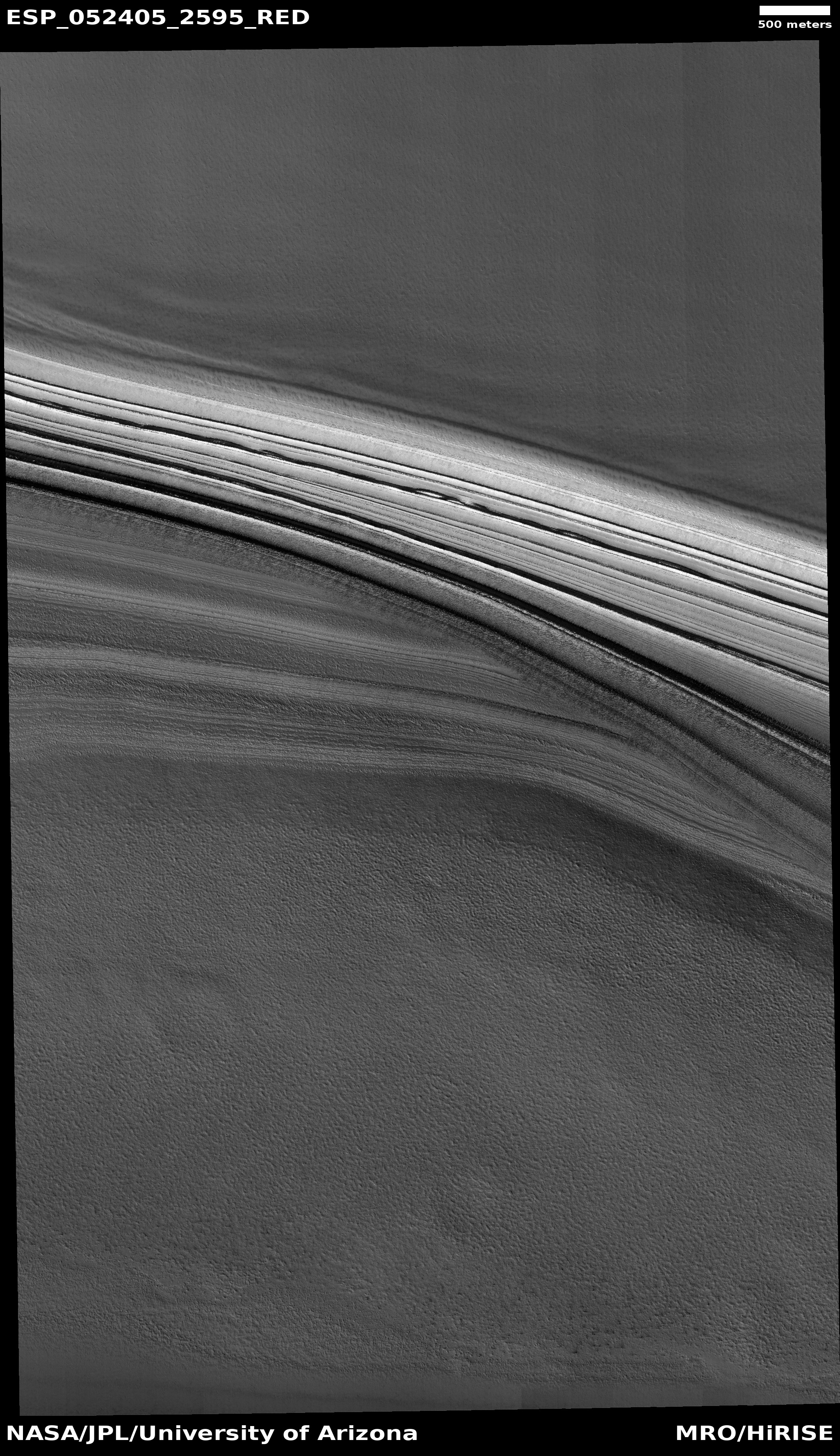
| 12:21, 27 February 2018 | ESP 052405 2595icelayers.jpg (file) |  |
2.5 MB | Ice layers in northern ice cap, as seen by HiRISE under HiWish program Source: http://hirise.lpl.arizona.edu/ESP_052405_2595 Image credit: NASA/JPL/University of Arizona | 1 |
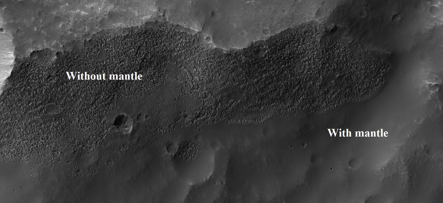
| 12:10, 27 February 2018 | Esp 037167 1445mantle.jpg (file) |  |
565 KB | Parts of surface with and without mantle, as seen by HiRISE under HiWish program Mantle may supply future colonists with water. Source: http://hirise.lpl.arizona.edu/ESP_037167_1445 Image credit: NASA/JPL/University of Arizona | 1 |
| 12:03, 27 February 2018 | 45917 2220gulliesmantle.jpg (file) |  |
164 KB | Close view of latitude dependent mantle, as seen by HiRISE under HiWish program A certain percentage of the mantle is ice; hence we may obtain water from this for future colonists. Source: http://hirise.lpl.arizona.edu/ESP_045917_2220 Image Credit:... | 1 |
| 11:59, 27 February 2018 | 46444 2225mantle.jpg (file) |  |
151 KB | Latitude dependent mantle, as seen by HiRISE under HiWish program A certain percentage of mantle is ice. Source: http://hirise.lpl.arizona.edu/ESP_046444_2225 Image Credit: NASA/JPL/University of Arizona | 1 |
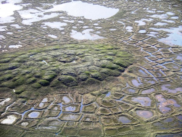
| 11:51, 27 February 2018 | Melting pingo wedge ice.jpg (file) |  |
104 KB | Pingo on Earth with melting near Tuktoyaktuk, Northwest Territories, Canada. Source: Originally uploaded to English Wikipedia by en:User:ChrisNF 16 August 2007, as w:Image:Melting pingo wedge ice.jpg. Author: Emma Pike | 1 |
| 11:46, 27 February 2018 | ESP 046359 1250-2pingoscale.jpg (file) |  |
257 KB | Possible pingo, as seen by HiRISE under HiWish program Location is the Phaethontis quadrangle. Source: http://hirise.lpl.arizona.edu/ESP_046359_1250 Image credit: NASA/JPL/University of Arizona/Secosky | 1 |
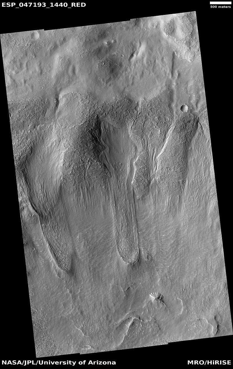
| 11:39, 27 February 2018 | ESP 047193 1440tongues.jpg (file) |  |
227 KB | Tongue shaped glaciers in Hellas quadrangle, as seen by HiRISE under HiWish program Source: http://hirise.lpl.arizona.edu/ESP_047193_1440 Image credit: NASA/JPL/University of Arizona/Secosky | 1 |
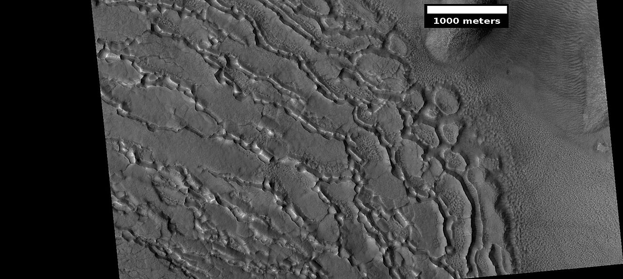
| 20:25, 26 February 2018 | ESP 042198 2235pyramid.jpg (file) |  |
163 KB | Upper plains unit breaking up, by starting with cracks Image taken with HiRISE under HiWish program Source: http://hirise.lpl.arizona.edu/ESP_042198_2235 Image credit: NASA/JPL/University of Arizona | 1 |
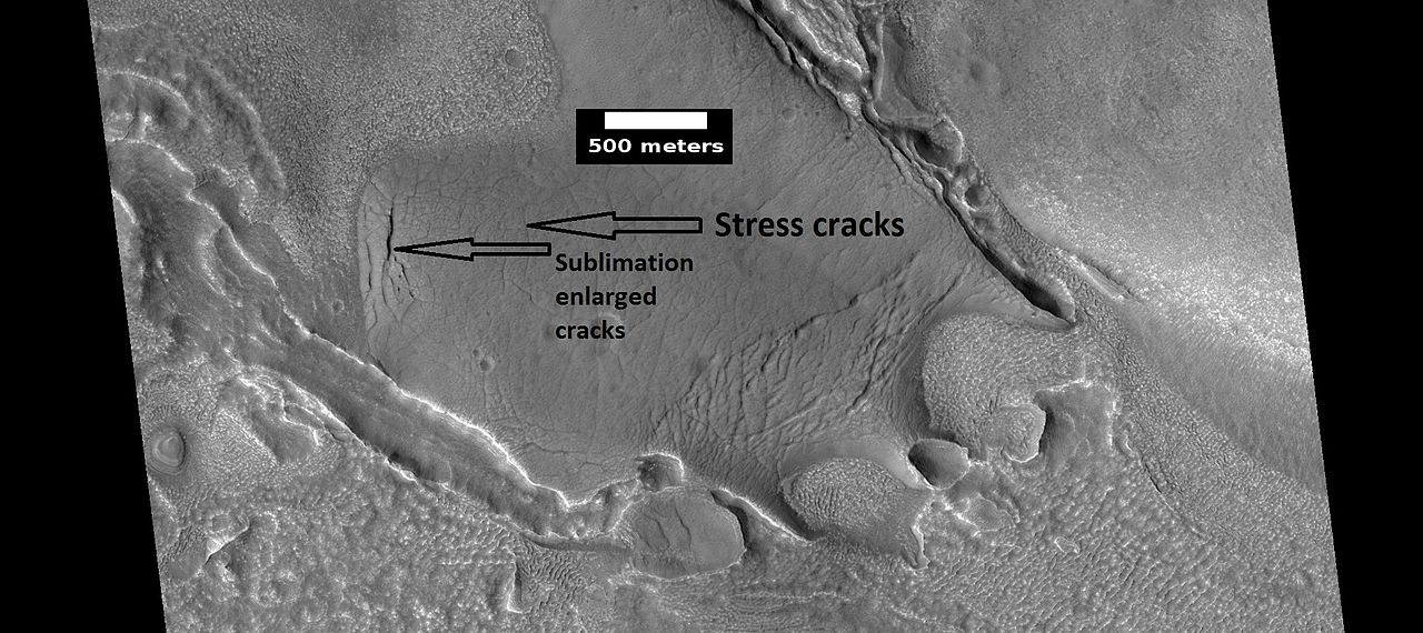
| 20:18, 26 February 2018 | ESP 028339 2245headarticle.jpg (file) |  |
137 KB | Ribbed terrain in the upper plains unit, as seen by HiRISE under the HiWish program Small cracks become larger and larger because the more surface area the more sublimation. Source: http://hirise.lpl.arizona.edu/ESP_028339_2245 Image credit: NA... | 1 |


