Uploads by Suitupandshowup
This special page shows all uploaded files.
| Date | Name | Thumbnail | Size | Description | Versions |
|---|---|---|---|---|---|
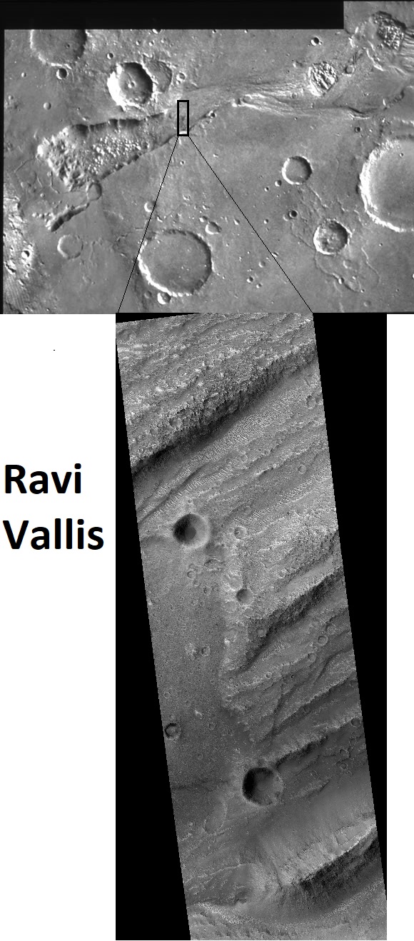
| 05:59, 13 May 2021 | 68206 1790ravicomposite.jpg (file) |  |
244 KB | The Source Region of the Outflow Channel Ravi Vallis (1°S,42°W) This mosaic of the head of Ravi Vallis shows a 300-kilometer-long portion of the channel. Like many other channels that empty into the northern plains of Mars, Ravi Vallis originates in a region of collapsed and disrupted (“chaotic”) terrain within the planet's older, cratered highlands. Structures in these channels (slides #24 and #25) indicate that the channels were carved by liquid water moving at high flow rates. The abrupt... | 1 |
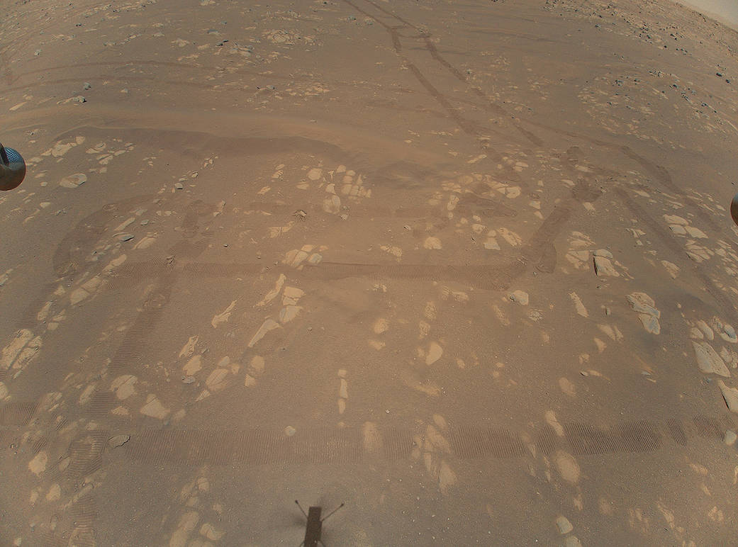
| 17:00, 25 April 2021 | Helicoptersurfacepia24593-1400.jpg (file) |  |
96 KB | This is the first color image of the Martian surface taken by an aerial vehicle while it was aloft. The Ingenuity Mars Helicopter captured it with its color camera during its second successful flight test on April 22, 2021. At the time this image, Ingenuity was 17 feet (5.2 meters) above the surface and pitching (moving the camera’s field of view upward) so the helicopter could begin its 7-foot (2-meter) translation to the west – away from the rover. The image, as well as the inset showing a... | 1 |
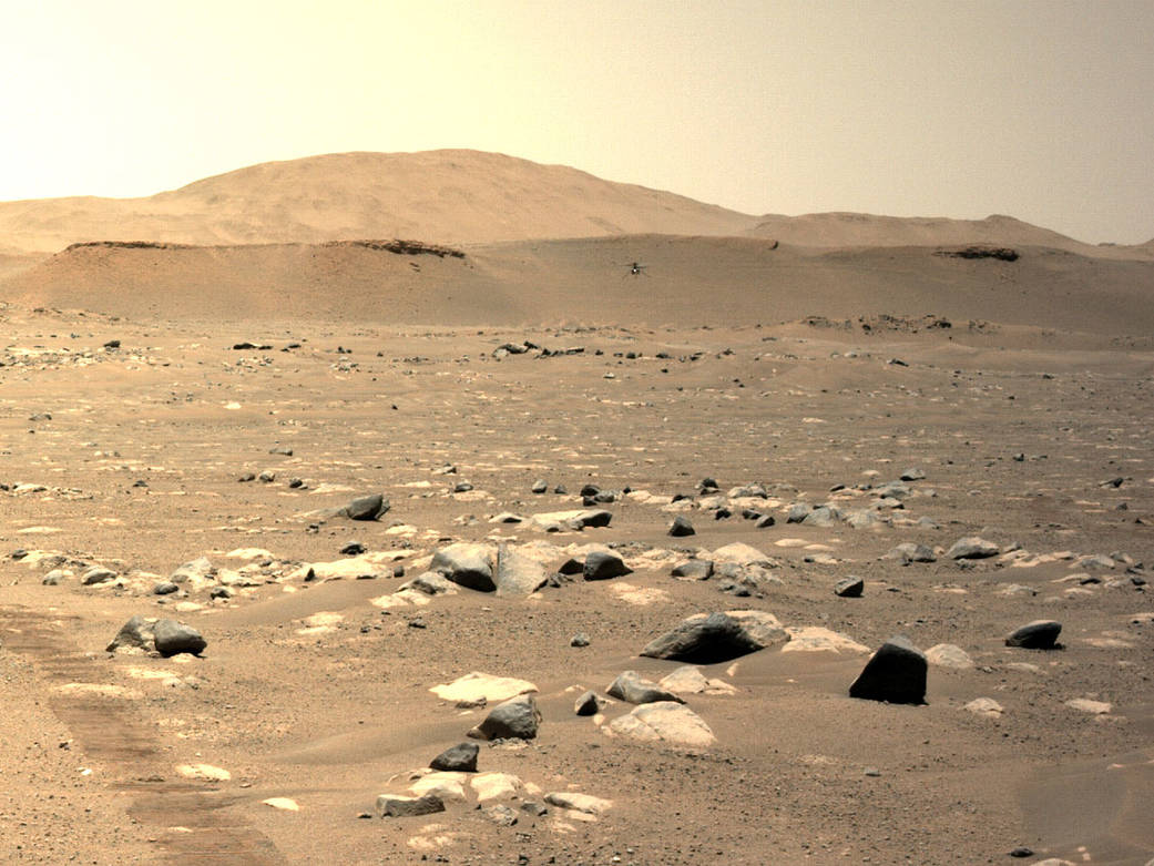
| 16:51, 25 April 2021 | Thirdflightpia24624.jpg (file) |  |
130 KB | NASA’s Ingenuity Mars Helicopter can be seen hovering during its third flight on April 25, 2021, as seen by the left Navigation Camera aboard NASA’s Perseverance Mars rover. The Ingenuity Mars Helicopter was built by JPL, which also manages this technology demonstration project for NASA Headquarters. Credit: NASA/JPL-Caltech | 1 |
| 14:28, 24 April 2021 | Ingenuitypia24581-1200.jpg (file) |  |
242 KB | Wide view of Ingenuity This image was captured by the Mastcam-Z imager on NASA’s Perseverance Mars rover on the following sol, April 8, 2021. Source: https://www.nasa.gov/perseverance/images Credit: NASA/JPL-Caltech | 1 |
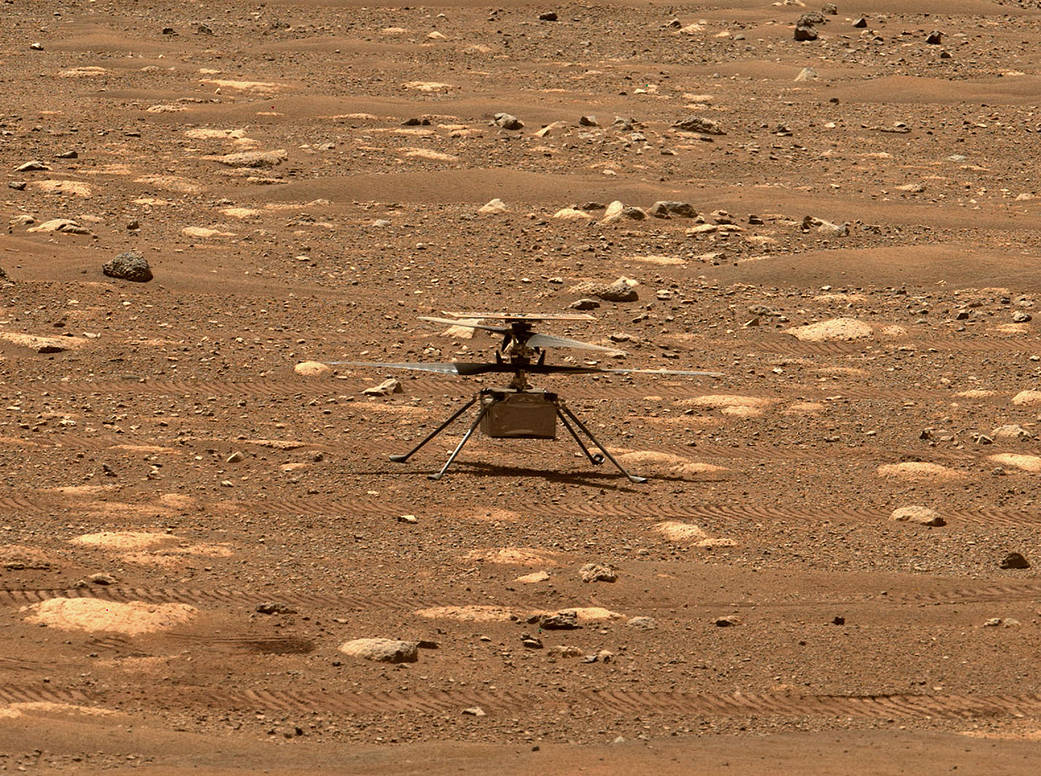
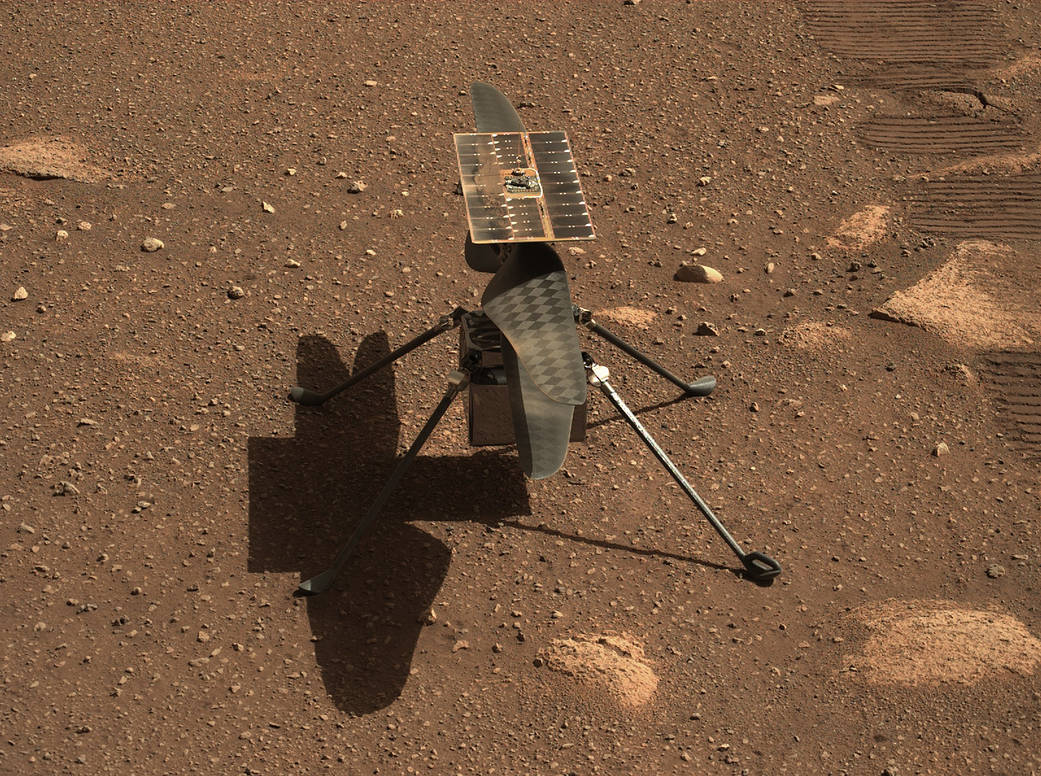
| 14:26, 24 April 2021 | Ingenuity1-pia24547-mastcam-z gives ingenuity.jpg (file) |  |
242 KB | Close up of Ingenuity as seen with mastcam z. Source: https://www.nasa.gov/perseverance/images Credit: NASA/JPL-Caltech | 1 |
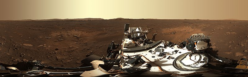
| 09:16, 9 March 2021 | PerseveranceMastcam-Z's First 360-Degree Panorama (1).jpg (file) | .jpg) |
56 KB | This is the first 360-degree panorama taken by Mastcam-Z, a zoomable pair of cameras aboard NASA’s Perseverance Mars rover. Source: https://mars.nasa.gov/resources/25640/mastcam-zs-first-360-degree-panorama/ Image credit: NASA/JPL-Caltech/ASU/MSSS | 1 |
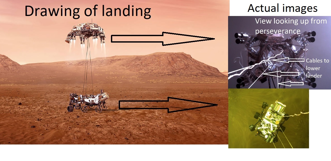
| 15:35, 8 March 2021 | Perseverancelandingcompositelabeled.jpg (file) |  |
252 KB | Drawing and actual pictures of Perseverance landing on Mars. Source: https://www.nasa.gov/image-feature/jpl/perseverance-touches-down-on-mars and https://www.nasa.gov/perseverance/images Image credit: NASA/JPL-Caltech/Secosky | 1 |
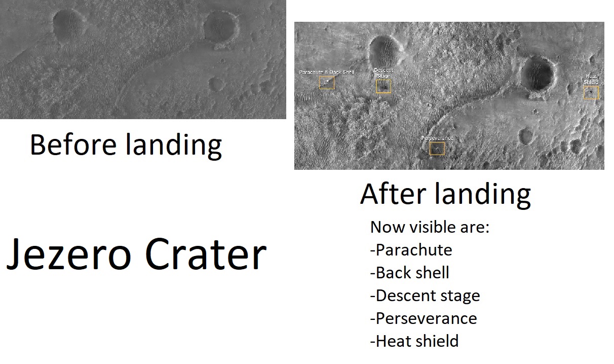
| 11:14, 8 March 2021 | Perseverancebeforeafter.jpg (file) |  |
232 KB | Jezero Crater before and after Perseverance landed as seen by HiRISE Source: https://www.nasa.gov/image-feature/jpl/perseverance-and-mars-2020-spacecraft-components-on-the-surface Credit: NASA/JPL-Caltech/University of Arizona | 1 |
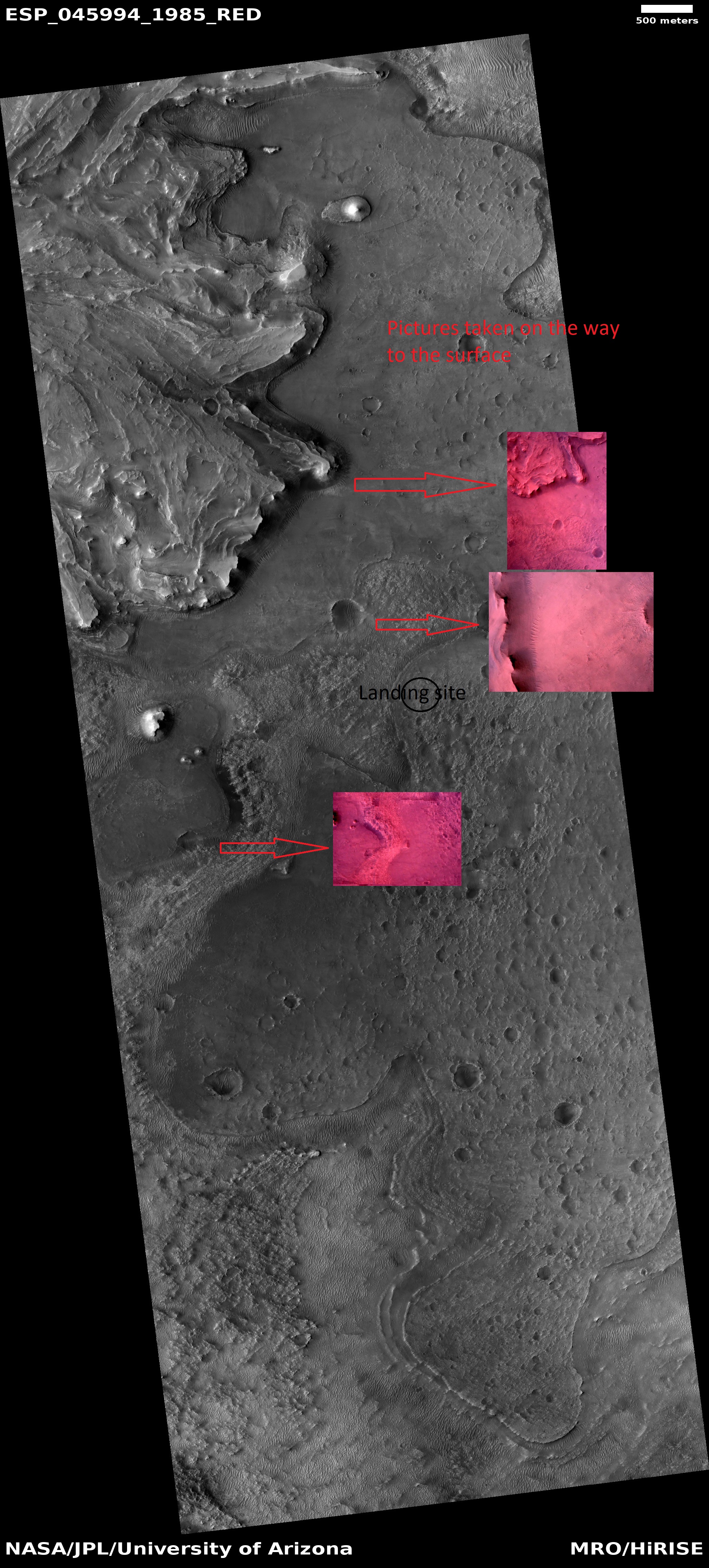
| 11:02, 8 March 2021 | Perseverancelandingcomposite4arrows.jpg (file) |  |
2.53 MB | Pictures (in pink) taken from Perseverance before landing and matched up with features from orbit. Image Credit: NASA/JPL-Caltech and NASA/JPL/University of Arizona Source: https://mars.nasa.gov/mars2020/multimedia/raw-images/ and HiRISE.lpl.arizona.edu/ESP_45994_1985 | 1 |
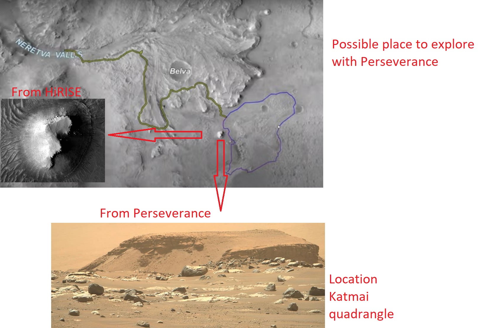
| 10:42, 8 March 2021 | Perseverancetransvers.jpg (file) | 335 KB | Possible paths that Perseverance may undertake. A mesa that may be visited is showed from HiRISE and from Perseverance. Image credit: NASA/JPL-Caltech/University of Arizona Source: https://www.nasa.gov/image-feature/jpl/the-road-ahead-for-perseverance | 1 | |
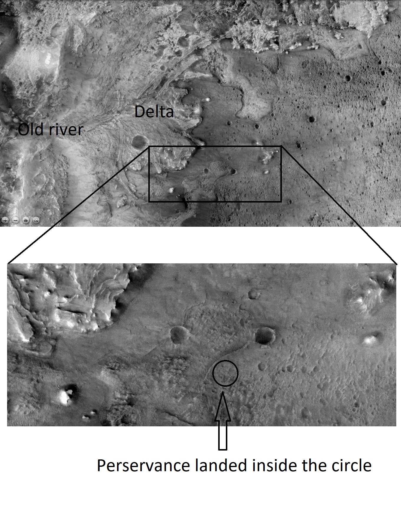
| 09:31, 8 March 2021 | ESP 045994 1985jezerocroppedcircle.jpg (file) |  |
476 KB | Jezero crater as seen by HiRISE. Perseverance landed inside circle. Source: hirise.lpl.arizona.edu/ESP_45994_1985 Image credit: NASA/JPL/University of Arizona | 1 |
| 09:28, 8 March 2021 | ESP 045994 1985jezerolcircle.jpg (file) |  |
2.48 MB | Jezero crater as seen by HiRISE. Source: hirise.lpl.arizona.edu/ESP_45994_1985 Image credit: NASA/JPL/University of Arizona | 1 |
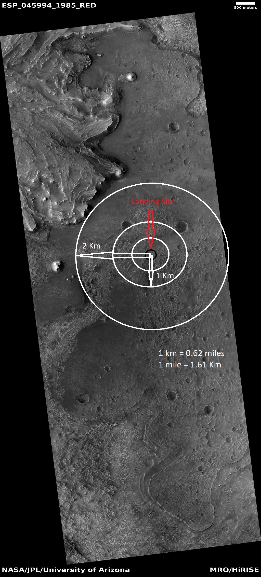
| 09:02, 8 March 2021 | ESP 045994 1985jezerokmcircles.jpg (file) |  |
781 KB | Jezero crater as seen by HiRISE. Circles indicate distances from landing site. Source: hirise.lpl.arizona.edu/ESP_45994_1985 Image credit: NASA/JPL/University of Arizona | 1 |
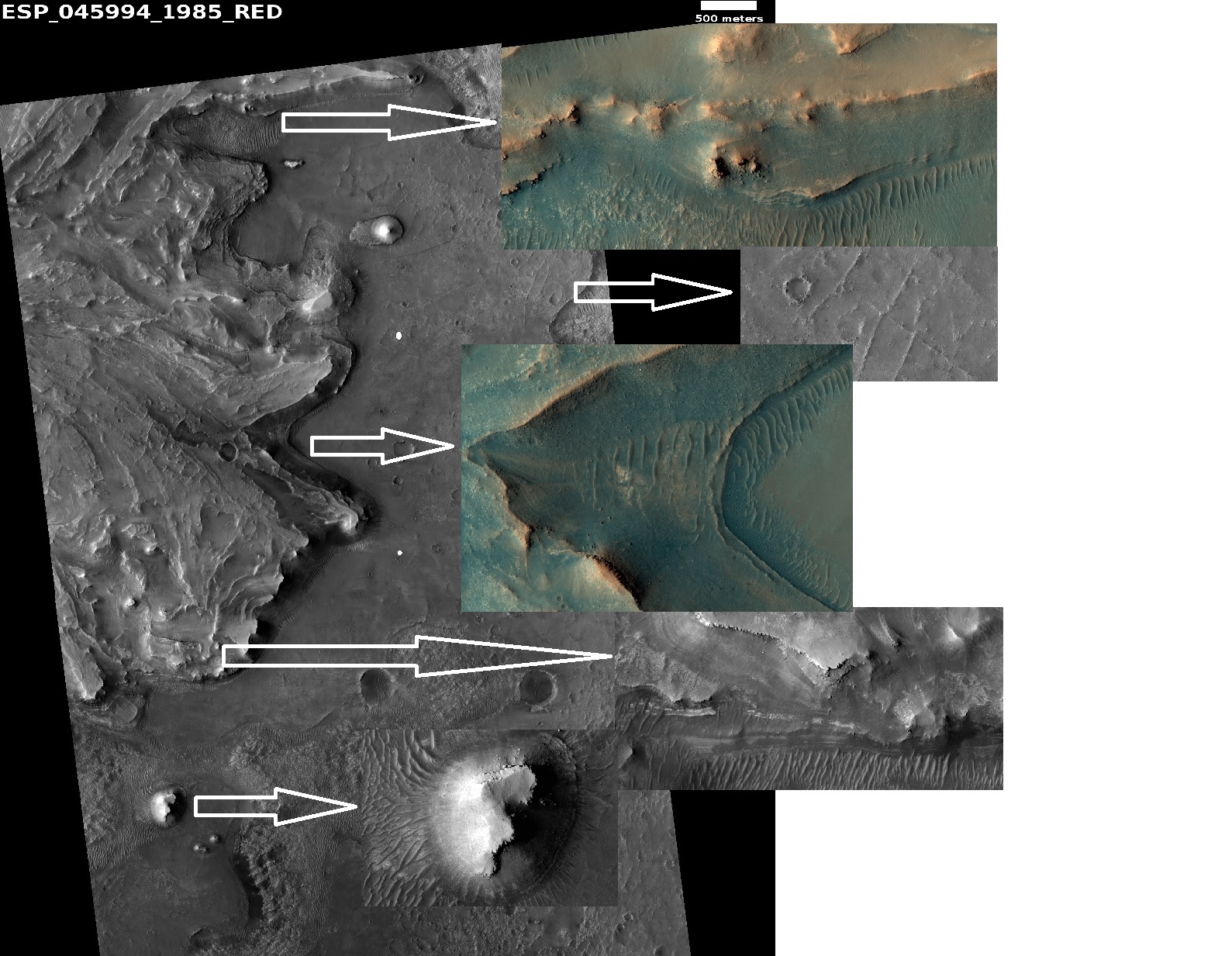
| 09:23, 20 February 2021 | 45994 1985jezweocompositecompositearrows.jpg (file) |  |
570 KB | Jezero crater as seen by HiRISE. Arrows show enlargements of features around delta. Source: hirise.lpl.arizona.edu/ESP_45994_1985 Image credit: NASA/JPL/University of Arizona | 1 |
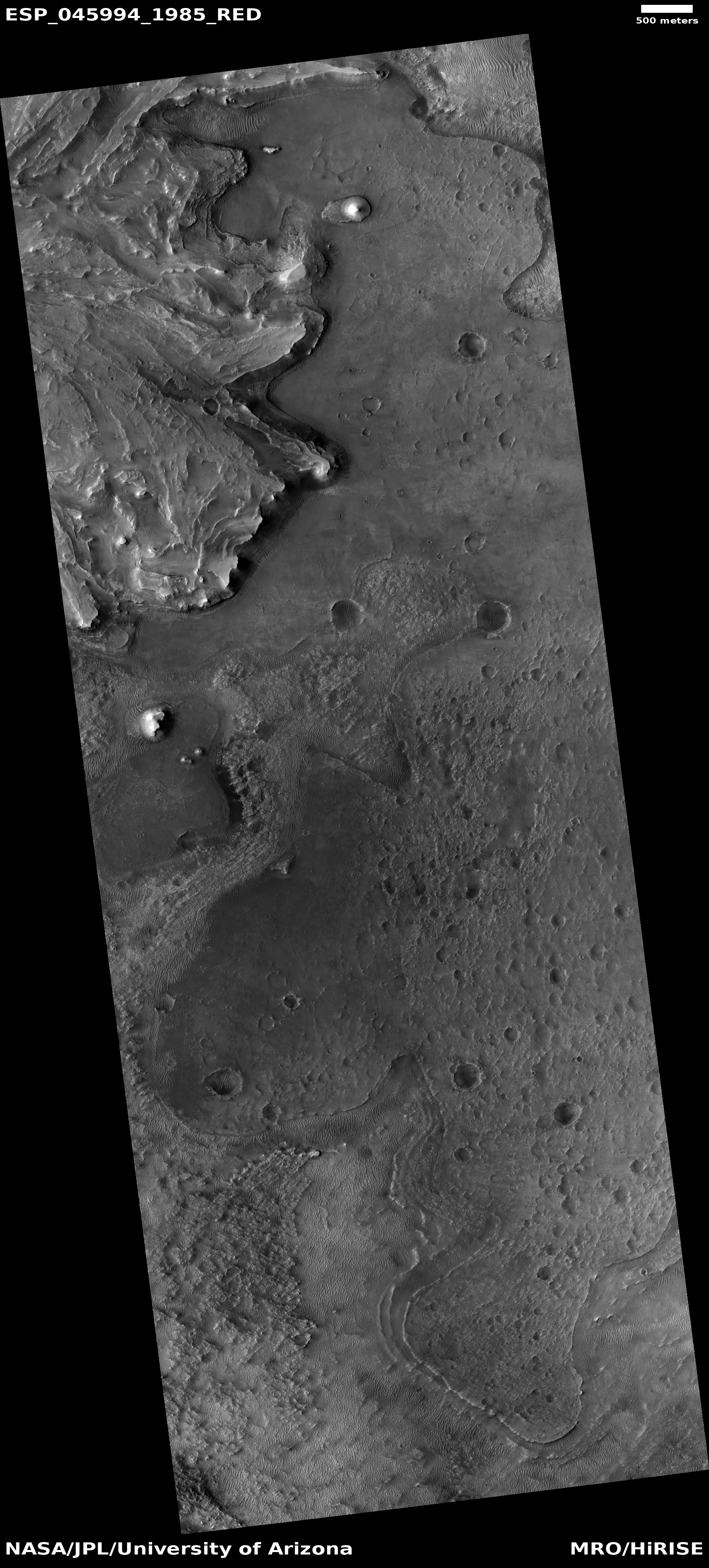
| 08:51, 19 February 2021 | ESP 045994 1985jezero.jpg (file) |  |
2.37 MB | Landing site for Perseverance Rover in Jezero Crater, as seen by CTX. Source: http://hirise.lpl.arizonia.edu/ESP_045994_1985 Image credit: NASA/JPL/University of Arizona | 1 |
| 08:48, 19 February 2021 | Jezerocloselabeledforlanding.jpg (file) |  |
725 KB | Landing site for Perseverance Rover in Jezero Crater, as seen by CTX. Source: http://viewer.mars.asu.edu/planetview/inst/ctx/F04_037396_1985_XN_18N282W#P=F04_037396_1985_XN_18N282W&T=2 Image credit: NASA/MSSS | 1 |
| 07:30, 17 February 2021 | Jezerocraterclose.jpg (file) |  |
319 KB | 1 | |
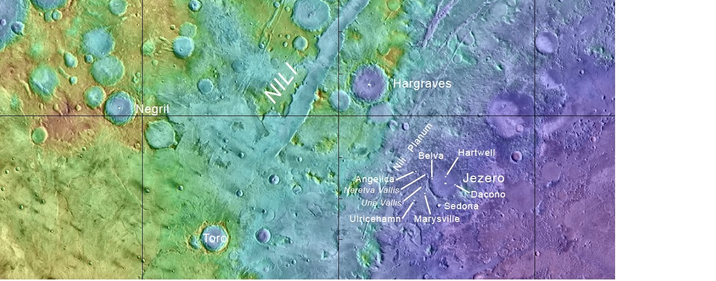
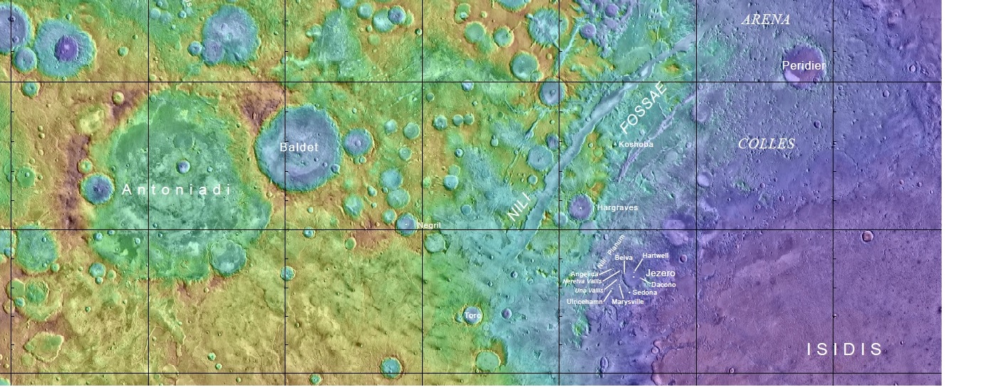
| 07:17, 17 February 2021 | Jezerocraterwidenames.jpg (file) |  |
390 KB | Map with names of features near Jezero Crater Source: https://planetarynames.wr.usgs.gov/images/mc13_2014.pdf Picture credit: NASA/USGS | 1 |
| 09:12, 21 January 2021 | ESP 067414 0945swisscheesechanges20112020.jpg (file) |  |
1,007 KB | HiRISE images showing changes from 2011 to 2020. Source: https://www.uahirise.org/ESP_067414_0945 Image credit: NASA/JPL/University of Arizona | 1 |
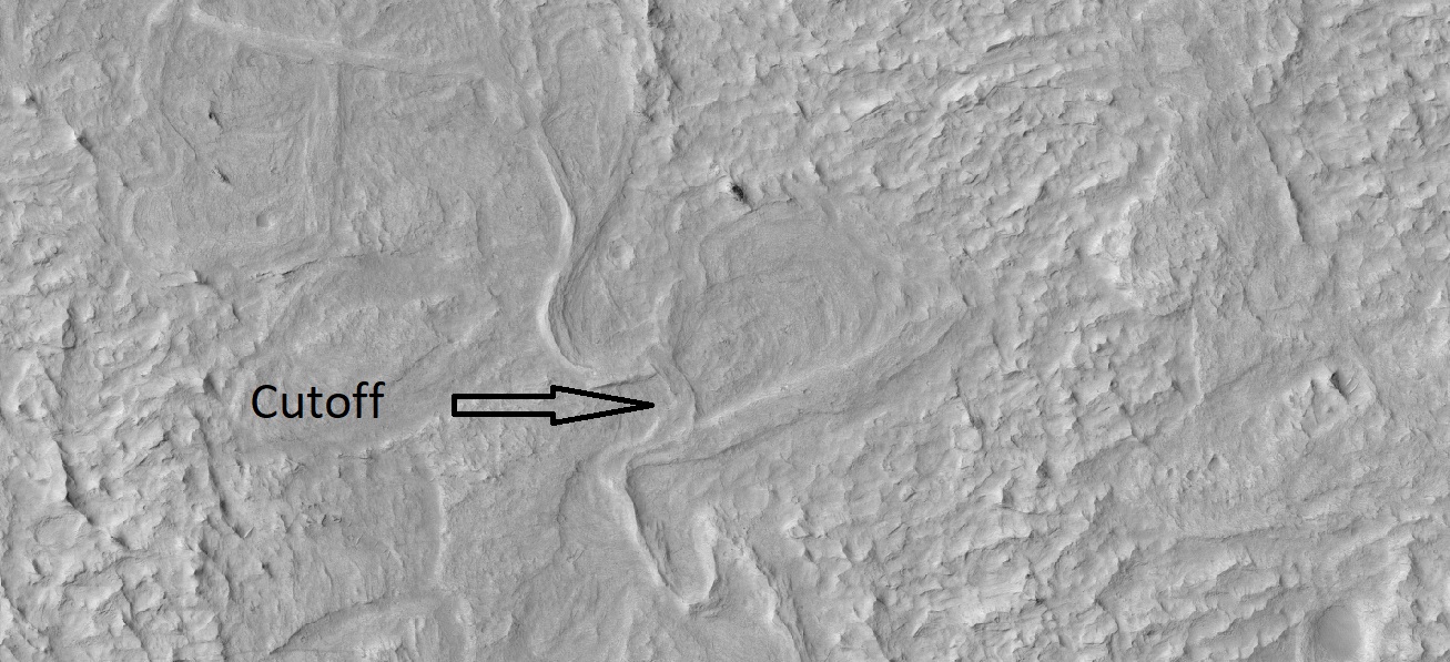
| 14:18, 21 December 2020 | 34189 1740cutoff.jpg (file) |  |
320 KB | Cutoff meander. This forms as a river cuts its outer bank and curves more and more, until it decides to take a “short-cut.” The abandoned channel may have formed an oxbow lake, when water was present. This type of river system forms slowly over time, unlike the catastrophic flood channels seen elsewhere on Mars. Source: https://www.uahirise.org/ESP_034189_1740 Image credit: NASA/JUPL/University of Arizona/Secosky | 1 |
| 10:34, 30 September 2020 | Lakessouthpole.jpeg (file) |  |
52 KB | Radar data showing possible lakes under south pole ice cap. Source: https://www.livescience.com/mars-hiding-salty-subsurface-lakes.html?utm_source=Selligent&utm_medium=email&utm_campaign=9160&utm_content=LVS_newsletter+&utm_term=2946561&m_i=NcWUmWPZCNUUBcfjrLEXvWUmBWslMd0nk6QTmc7rtrRAM8m0_rsoL4i8sG3PazmneinVTm0HeW%2B5rIL0NctkmEHjhsPMlx3u7APzefANNh Image credit: Image credit: Elena Pettinelli et al, 2020. Nature. | 1 |
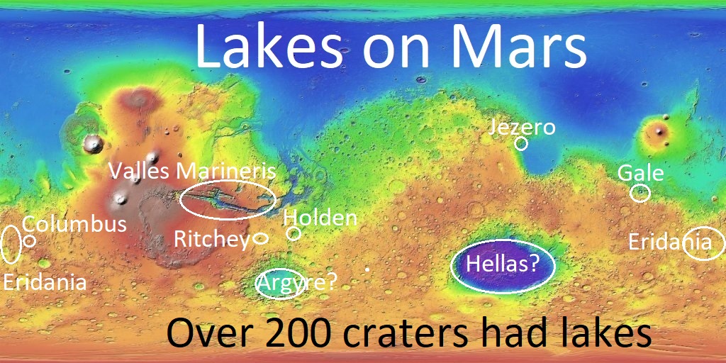
| 10:24, 18 September 2020 | Societytalksmarswith200.jpg (file) |  |
242 KB | Map showing locations of places on Mars thought to have lakes. Image Credit: NASA/USGS/USGS Astrogeology Center/Secosky Source: http://USGS | 1 |
| 13:25, 5 September 2020 | ESP 025698 1485pinksalt.jpg (file) |  |
3.88 MB | Color HiRISE image showing pick deposits that have been determined to be of salts. Source: https://static.uahirise.org/images/2012/details/cut/ESP_025698_1485.jpg Image Credit: NASA/JPL/University of Arizona | 1 |
| 05:45, 12 May 2020 | 64038 2155tarslabeled.jpg (file) |  |
230 KB | TAR's, as seen by HiRISE under HiWish program TAR's are a type of sand dune found in low places, especially on the floors of old channels. Source: http://hirise.lpl.arizona.edu/ESP_64038_2155 Image Credit: NASA/JPL/University of Arizona/Secosky | 1 |
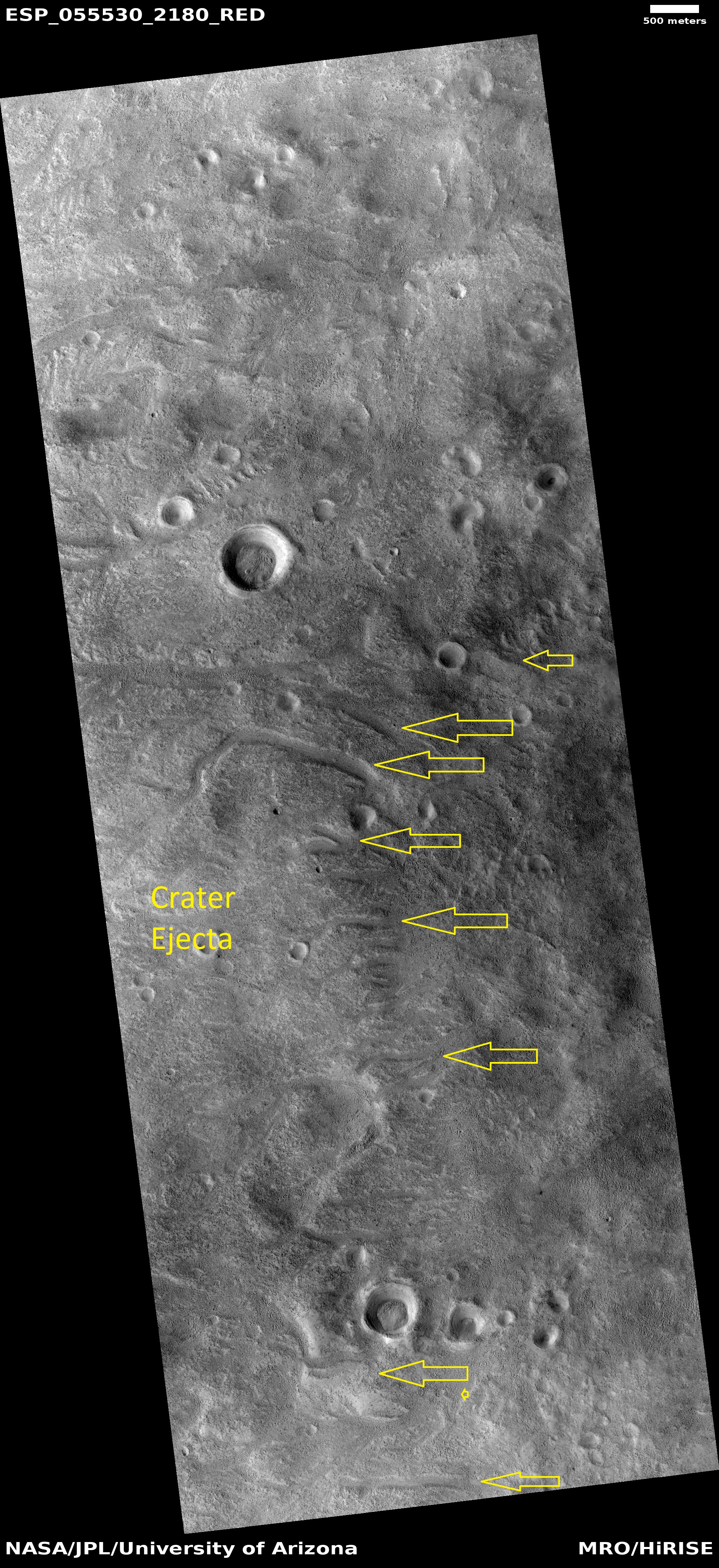
| 08:57, 21 April 2020 | ESP 055530 2180channels.jpg (file) |  |
3.4 MB | Channels on the edge of a crater's ejecta. The heat form the impact ejecta may have melted ice in the ground and formed the channels we see. Source: http://hirise.lpl.arizona.edu/ESP_055530_2180 Image credit: NASA/JPL/University of Arizona | 1 |
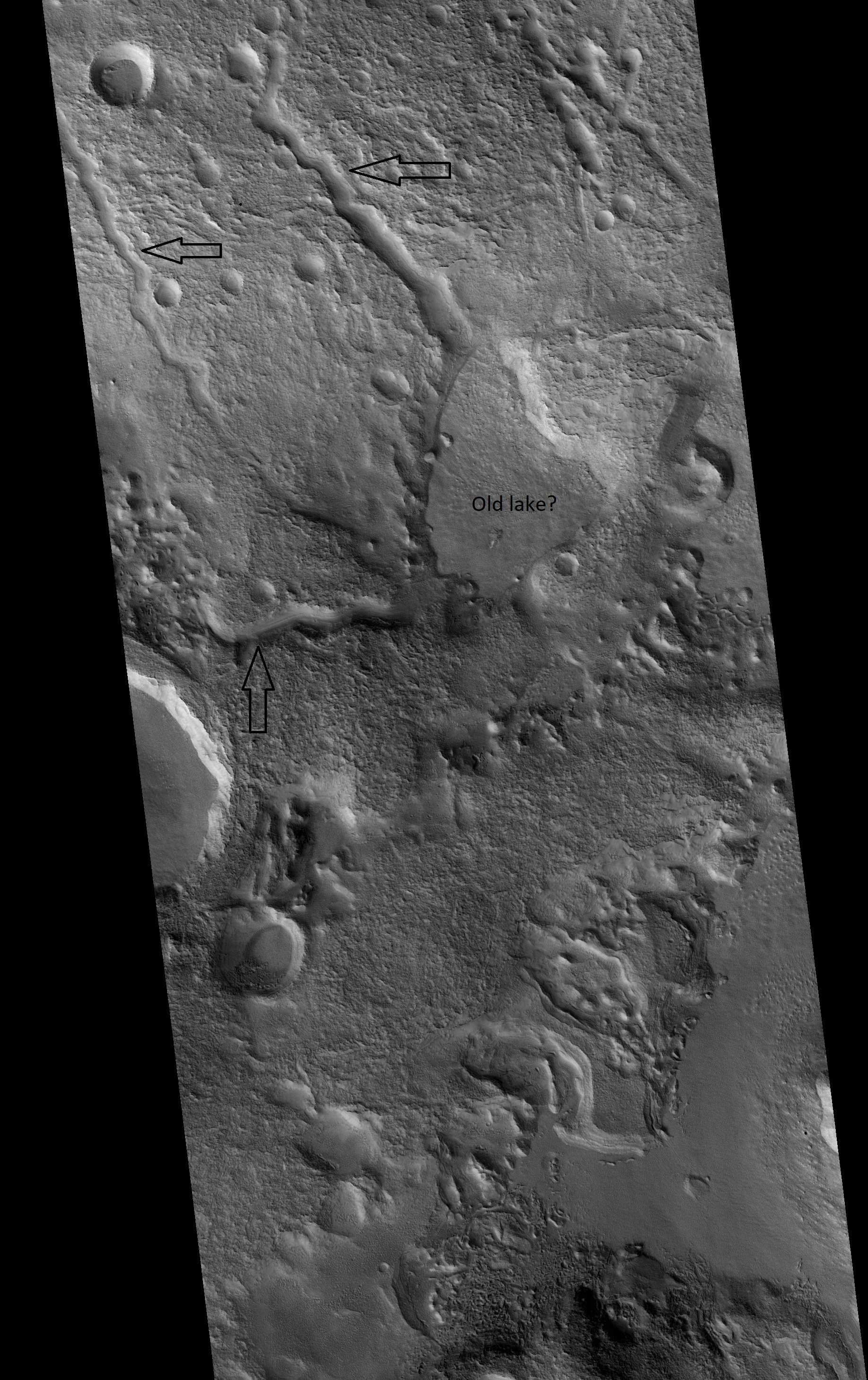
| 14:20, 20 April 2020 | ESP 056689 2210channelslowspotcropped.jpg (file) |  |
1.75 MB | Channels emptying into a low area in the Ismenius Lacus quadrangle, as seen by HiRISE under HiWish program Date Source http://hirise.lpl.arizonia.edu/ESP_056689_2210 Image credit: NASA/JPL/University of Arizona/Secosky | 1 |
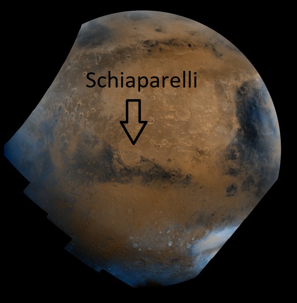
| 14:08, 20 April 2020 | Schiaparelli Hemisphere - PIA00004labeled.jpg (file) |  |
69 KB | This mosaic is composed of about 100 red- and violet- filter Viking Orbiter images. The images were acquired in 1980 during mid northern summer on Mars (Ls = 89 degrees). The center of the image is near the impact crater Schiaparelli (latitude -3 degrees, longitude 343 degrees). The limits of this mosaic are approximately latitude -60 to 60 degrees and longitude 280 to 30 degrees. The color variations have been enhanced by a factor of two. The large circular area with a bright yellow color... | 1 |
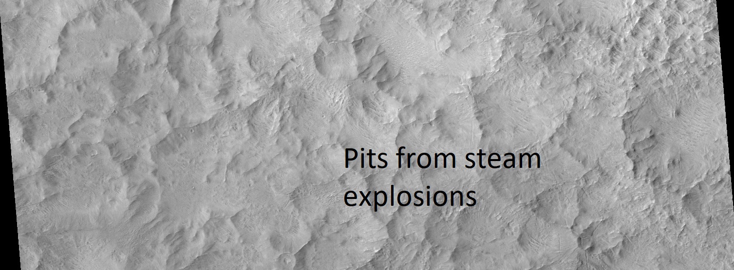
| 08:07, 18 April 2020 | ESP 012531 1435pits.jpg (file) |  |
304 KB | Pits on floor of Hale crater from steam explosions, as seen by HiRISE Hot molted rock fell after impact and caused steam explosions in the ice rich ground. Source: https://www.uahirise.org/https://www.uahirise.org/ESP_012531_1435 Image credit: NASA/JPL/University of Arizona/Secosky | 1 |
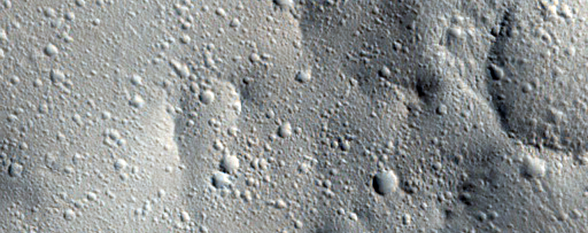
| 07:51, 18 April 2020 | ESP 030244 2040secondarycraters.jpg (file) |  |
339 KB | Secondary craters, as seen by HiRISE Source: https://www.uahirise.org/ESP_030244_2040 Image credit: NASA/JPL/University of Arizona | 1 |
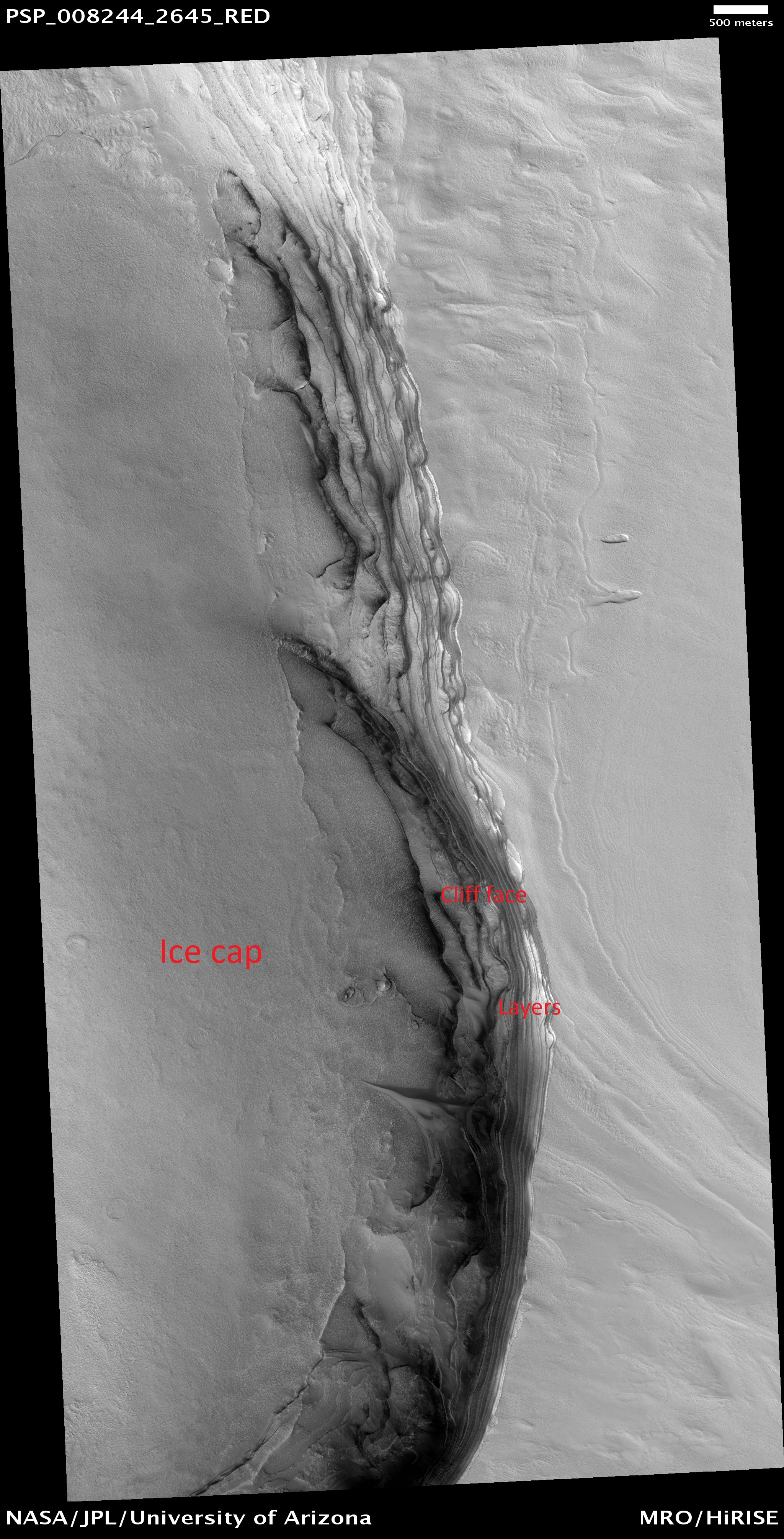
| 05:52, 18 April 2020 | PSP 008244 2645northicecaplabeled.jpg (file) |  |
2.66 MB | Lava tubes and lava flows, as seen by HiRISE Source: https://www.uahirise.org/PSP_008244_2645 Image credit: NASA/JPL/University of Arizona/Secosky | 1 |
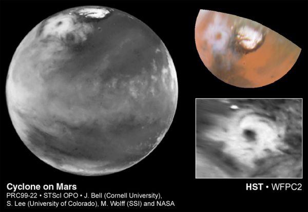
| 08:41, 17 April 2020 | Marscyclone hst.jpg (file) |  |
31 KB | Cyclone on Mars, as seen by HST. Source: https://apod.nasa.gov/apod/ap990520.html Credit: J. Bell (Cornell), S. Lee (Univ. Colorado), M. Wolff (SSI), et al., NASA | 1 |
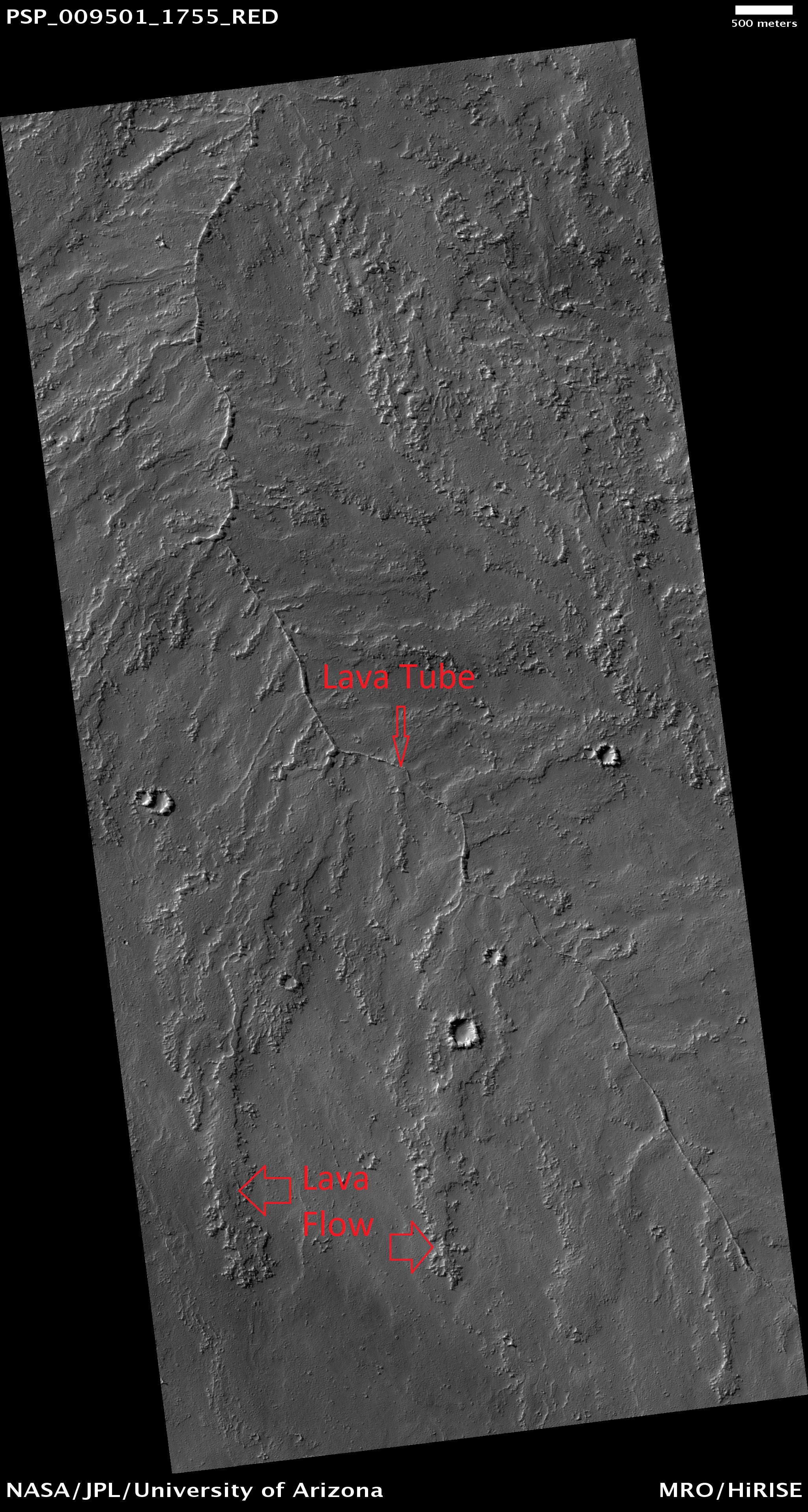
| 08:29, 17 April 2020 | PSP 009501 1755lavatube.jpg (file) |  |
2.55 MB | Lava tubes and lava flows, as seen by HiRISE https://www.uahirise.org/PSP_009501_1755 Image credit: NASA/JPL/University of Arizona/Secosky | 1 |
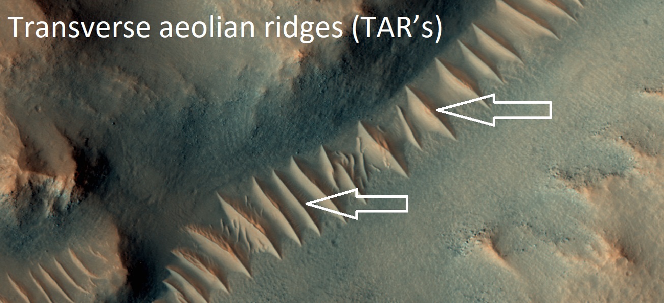
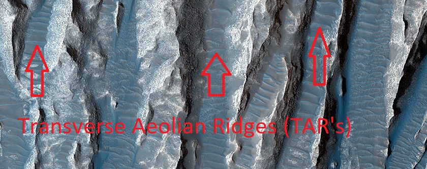
| 08:04, 17 April 2020 | ESP 042625 1655tars.jpg (file) |  |
763 KB | Transverse aeolian ridges (TAR's) Transverse aeolian ridges—or TAR—are mysterious, wind-blown features that are intermediate in size between ripples and much larger sand dunes. Ripples form from hopping sand grains, and dunes form from sand grains being blown over longer distances. One hypothesis for TAR formation is that larger grains like pebbles are rolled on top of smaller ripples; then, finer dust settles into the cracks, “inflating” the pebbles, making the TAR larger than typical rip... | 1 |
| 07:56, 17 April 2020 | ESP 039563 1730tars.jpg (file) |  |
194 KB | Transverse aeolian ridges (TAR's) These are sort of like small sand dunes. We do not understand these totally. Source: https://www.uahirise.org/ESP_039563_1730 Image credit: NASA/JPL/University of Arizona/Secosky | 1 |
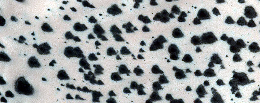
| 07:43, 17 April 2020 | ESP 011605 1170defrosting.jpg (file) |  |
320 KB | Defrosting The dark spots are where the ice has melted, allowing us to see the dark undersurface. This takes place each spring. https://www.uahirise.org/ESP_011605_1170 Image credit: NASA/JPL/University of Arizona | 1 |
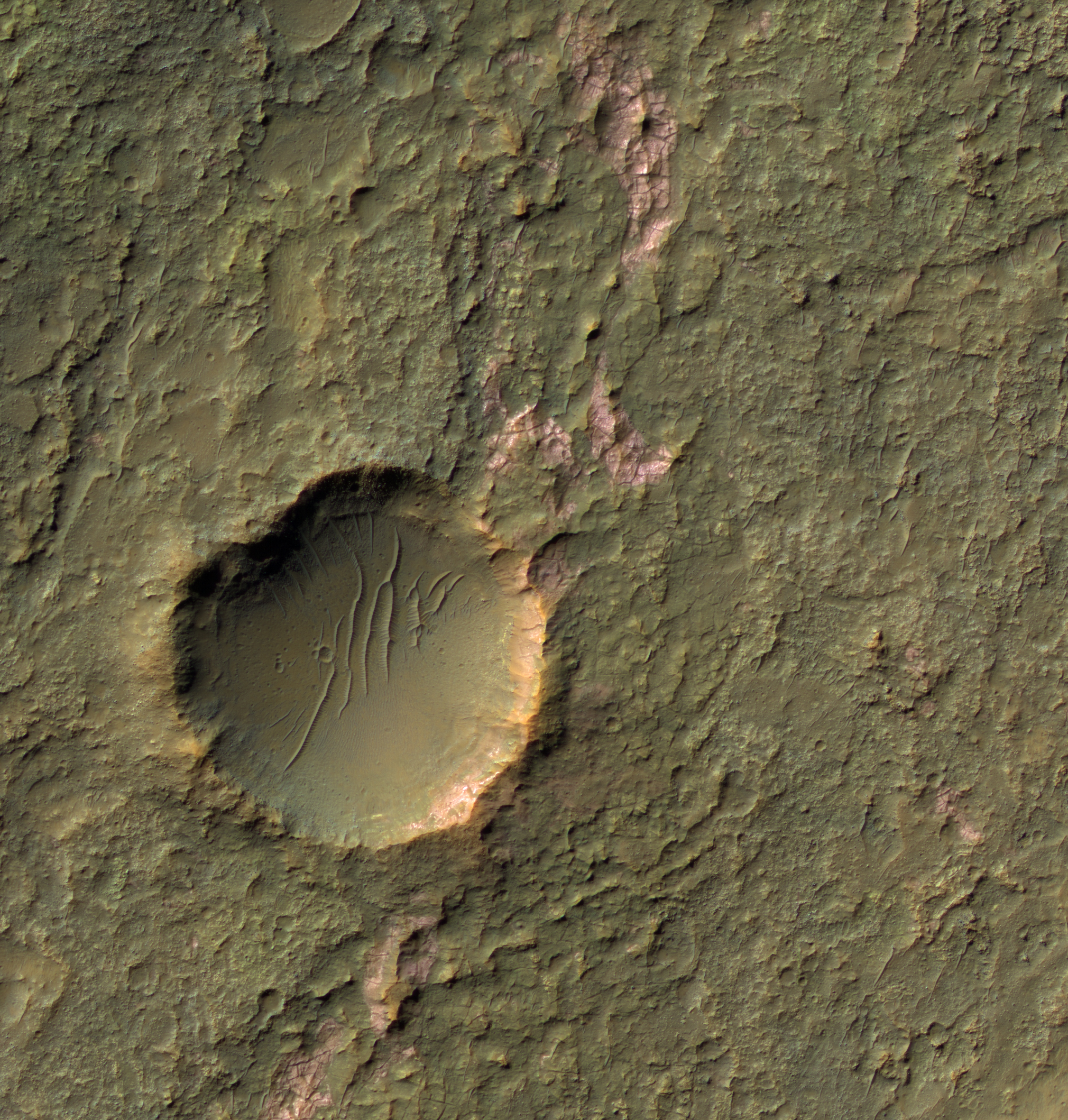
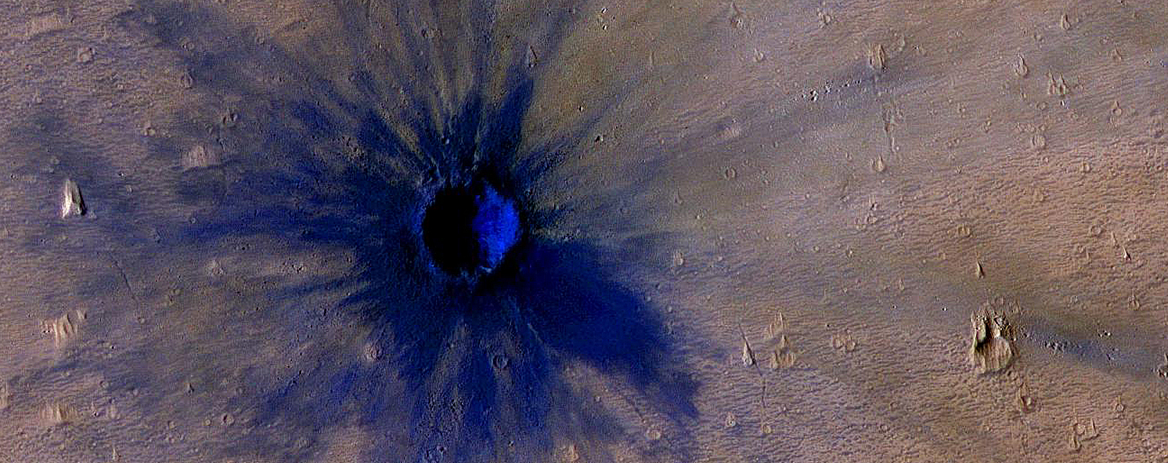
| 05:57, 17 April 2020 | ESP 011425 1775newcrater.jpg (file) |  |
1.18 MB | New crater The dark represents the dark surface that lies under the dust. It is the dark volcanic rock basalt. Image credit: NASA/JPL/University of Arizona Source: https://www.uahirise.org/ESP_011425_1775 | 1 |
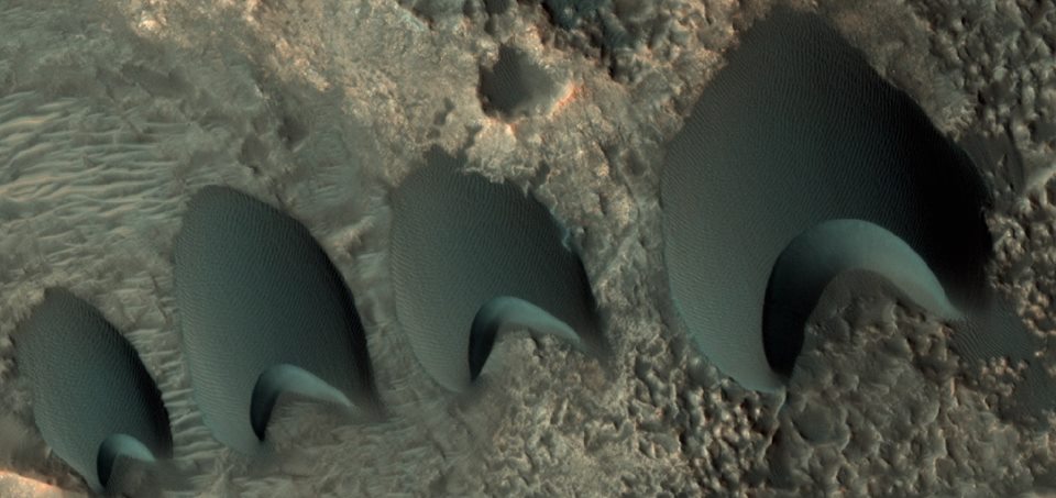
| 11:56, 16 April 2020 | ESP 55095 2170dunes.jpg (file) |  |
70 KB | Close, color view of dunes The location is near Sklodowski Crater in North Arabia Terra in the Ismenius Lacus quadrangle at 36.66 N and 0.787 E (ESP_55095_2170). Picture taken with HiRISE under HiWish program Source: http://hirise.lpl.arizona.edu/ESP_55095_2170 Image credit is NASA/JPL/University of Arizona. | 1 |
| 09:48, 16 April 2020 | ESP 035801 2210dipping.jpg (file) |  |
46 KB | Dipping layers The location is the Ismenius Lacus quadrangle at Latitude (centered) 40.417° N and Longitude 57.678° E. Source: http://hirise.lpl.arizona.edu/ESP_035801_2210 Image courtesy NASA/JPL/University of Arizona | 1 |
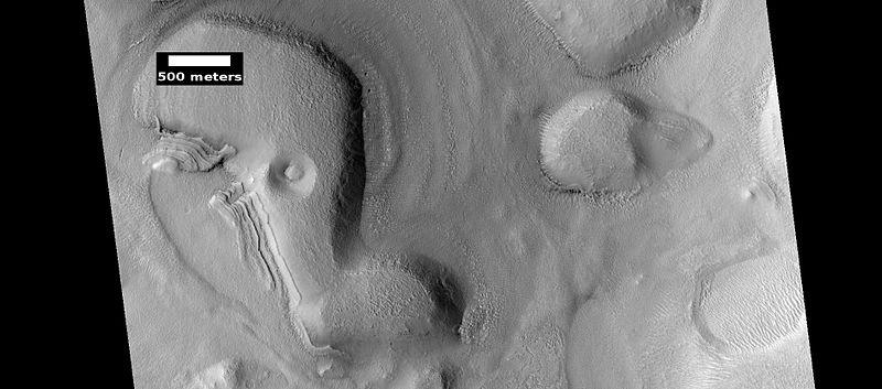
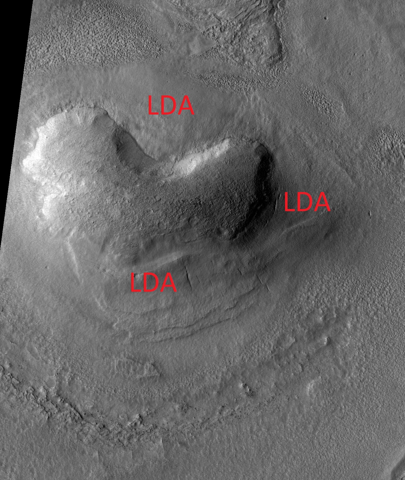
| 10:09, 15 April 2020 | ESP 036619 2275ldalabeled.jpg (file) |  |
808 KB | Lobate debris apron around a mound, as seen by HiRISE under HiWish program Source: http://hirise.lpl.arizona.edu/ESP_036619_2275 Image credit: NASA/JPL/University of Arizona/Secosky | 1 |
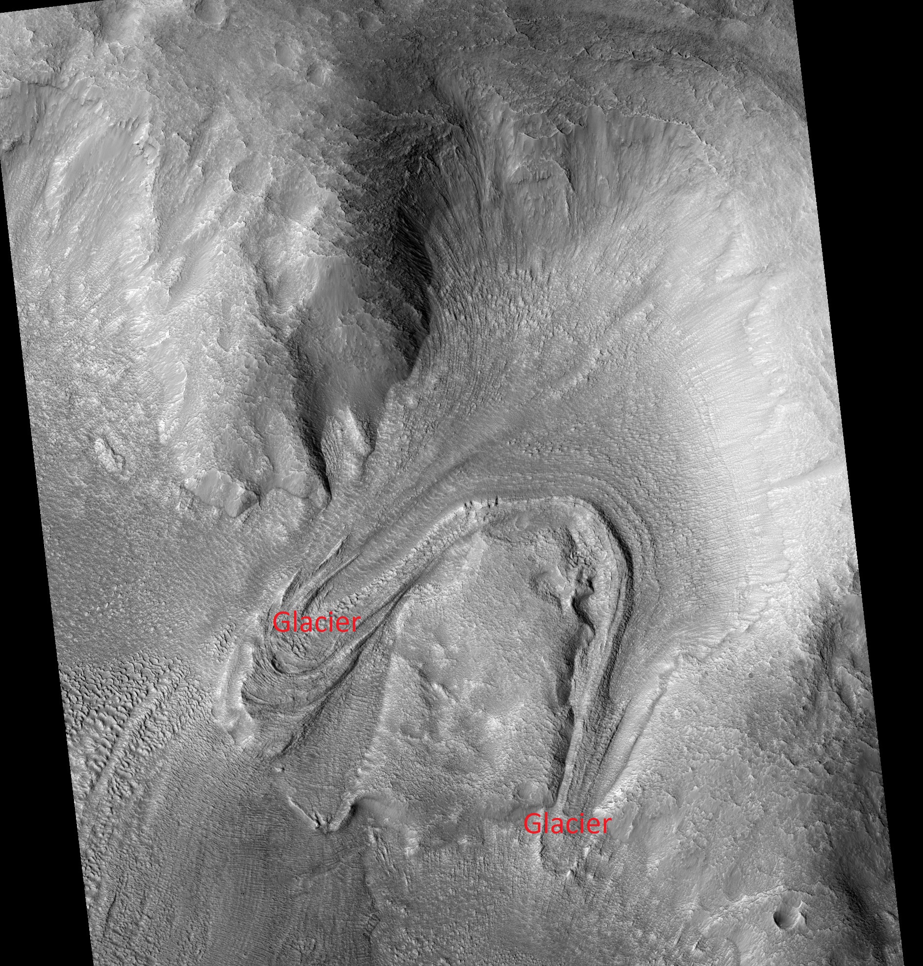
| 10:06, 15 April 2020 | ESP 035327 2255tongues.jpg (file) |  |
1.56 MB | Tongue-shaped glaciers created when flow ran into an obstacle, causing it to split into two. Source: http://hirise.lpl.arizona.edu/ESP_035327_2255 Image credit: NASA/JPL/University of Arizona/Secosky | 1 |
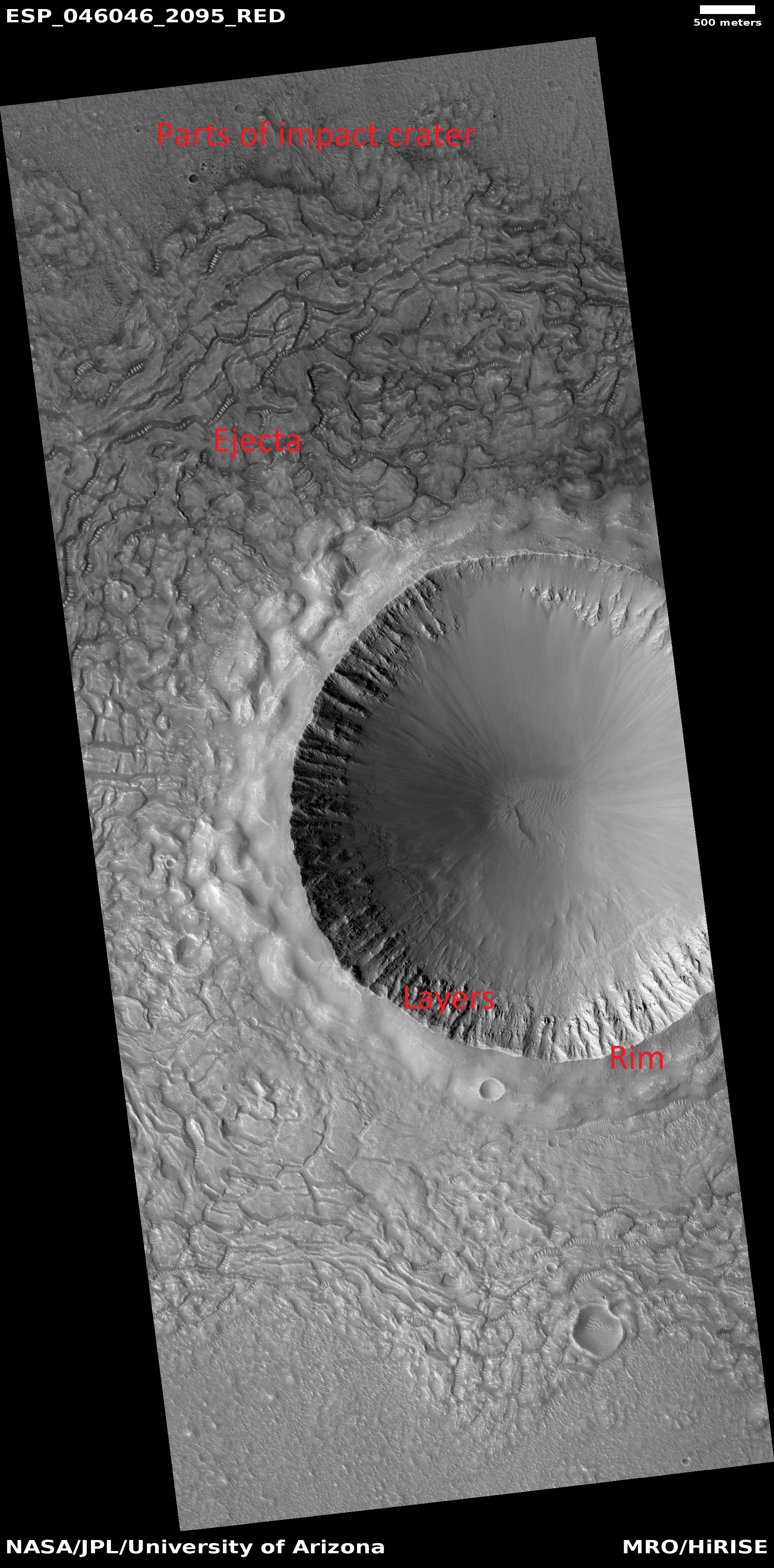
| 06:09, 15 April 2020 | ESP 046046 2095craterejectarim.jpg (file) |  |
2.18 MB | Parts of crater in Amenthes quadrangle quadrangle, as seen by HiRISE under HiWish program Source: http://hirise.lpl.arizona.edu/ESP_046046_2095 Image credit: NASA/JPL/University of Arizona/Jim Secosky | 1 |
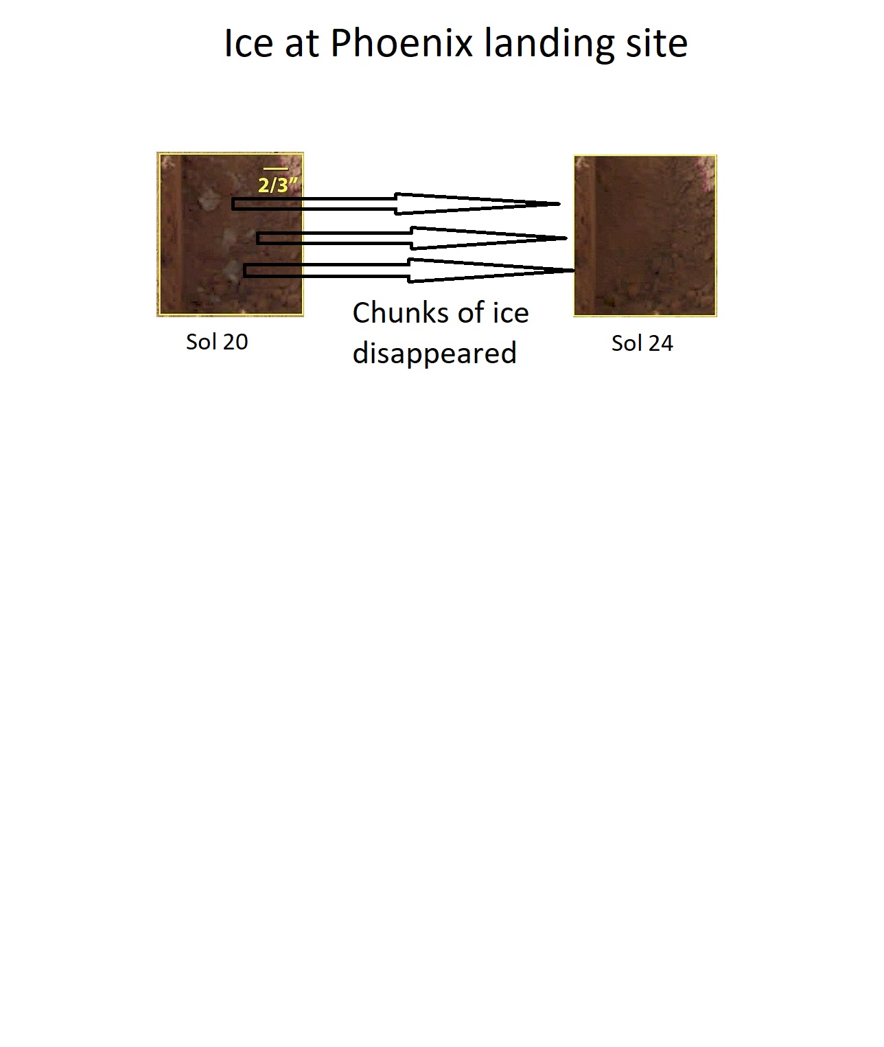
| 15:00, 12 April 2020 | Evaporatingicephoenix.jpg (file) |  |
112 KB | These color images were acquired by NASA's Phoenix Mars Lander's Surface Stereo Imager on the 21st and 25th days of the mission, or Sols 20 and 24 (June 15 and 19, 2008). These images show sublimation of ice in the trench informally called "Dodo-Goldilocks" over the course of four days. In the lower left corner of the left image, a group of lumps is visible. In the right image, the lumps have disappeared, similar to the process of evaporation. Date June 15 and June 19, 2008 Source http://ww... | 1 |
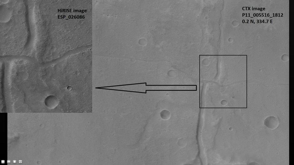
| 07:50, 7 April 2020 | 26086 1800fault.jpg (file) |  |
54 KB | Strike-slip fault in Hydaspis Chaos. Location is 0.2 N and 334.7 E (ESP_026086_1800). Background image is CTX image P11_005516_1812. Source: http://hirise.lpl.arizona.edu/ESP_ 26086_1800 Image credit is NASA/JPL/University of Arizona. Image credit is NASA/JPL-Caltech/Malin Space Science Systems for CTX image. | 1 |
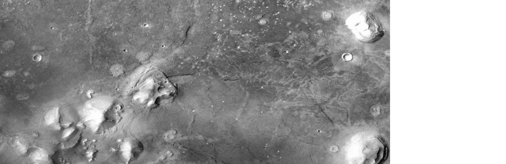
| 06:58, 21 March 2020 | FacectxF23 044929 2199 XI 39N010Wlabeled.jpg (file) |  |
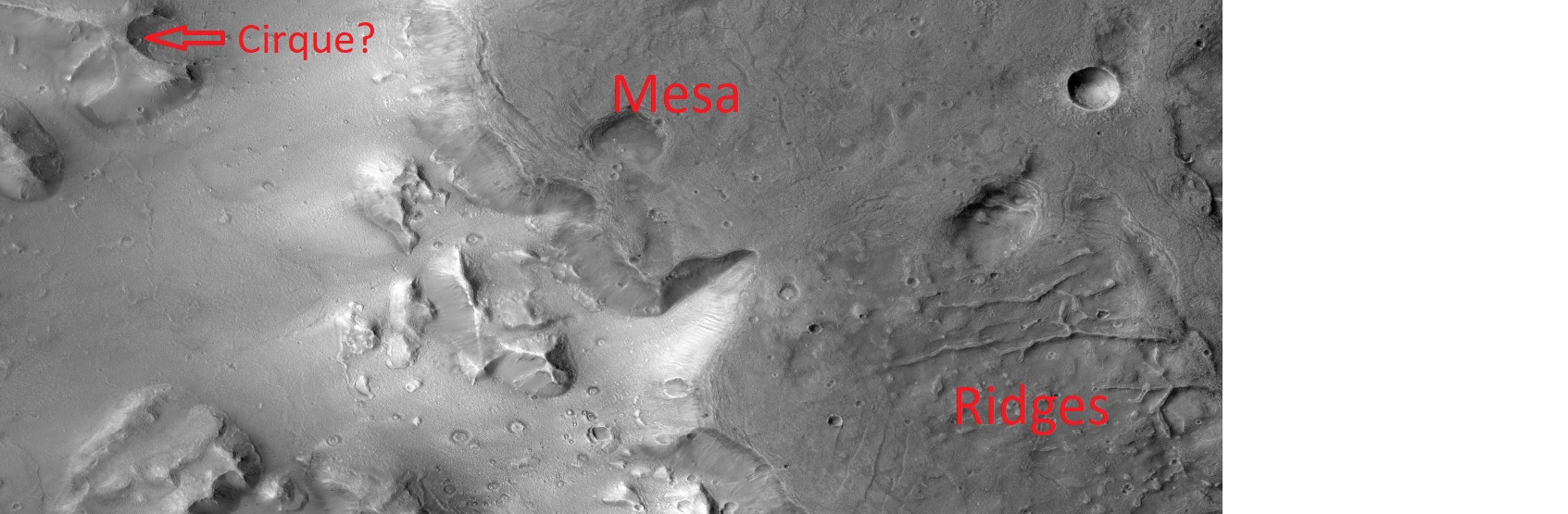
284 KB | Landforms near Face. Mesa, ridges, and possible cirques are present. A '''cirque''' (French, from the Latin word ''circus'') is an amphitheatre-like valley formed by glacial erosion. Alternative names for this landform are '''corrie''' (from Scottish Gaelic coire, meaning a pot or cauldron) and '''cwm''' (Welsh "valley"). A cirque may also be a similarly shaped landform arising from fluvial erosion. The concave shape of a glacial cirque is open on the downhill side, while the cupped secti... | 1 |
| 06:57, 21 March 2020 | FacectxF23 044929 2199 XI 39N010W.jpg (file) |  |
284 KB | Landforms near Face. Mesa, ridges, and possible cirques are present. A '''cirque''' (French, from the Latin word ''circus'') is an amphitheatre-like valley formed by glacial erosion. Alternative names for this landform are '''corrie''' (from Scottish Gaelic coire, meaning a pot or cauldron) and '''cwm''' (Welsh "valley"). A cirque may also be a similarly shaped landform arising from fluvial erosion. The concave shape of a glacial cirque is open on the downhill side, while the cupped secti... | 2 |
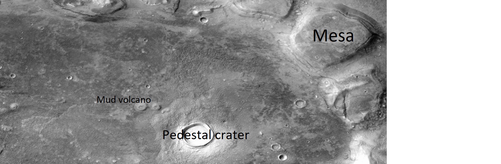
| 17:08, 19 March 2020 | Faceg22 026771 2213pedestal.jpg (file) |  |
332 KB | Terrain near the face on Mars. Mud volcano, mesa, and pedestal crater are visible. Possible erosion by glaciers. Source: http://viewer.mars.asu.edu/planetview/inst/ctx/G22_026771_2213 Image credit: NASA/MSSS/Secosky | 1 |
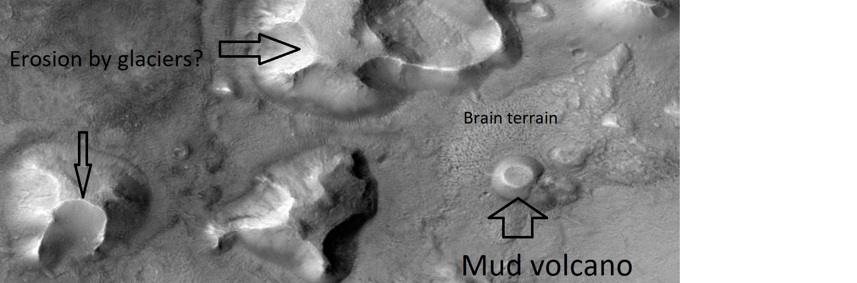
| 17:06, 19 March 2020 | FacectxT01 00807 2205glaciers.jpg (file) |  |
211 KB | Terrain near the face on Mars. Mud volcanoe and brain terrain are visible. Possible erosion by glaciers. Source: http://viewer.mars.asu.edu/planetview/inst/ctx/D02_027892_2219 Image credit: NASA/MSSS/Secosky | 1 |
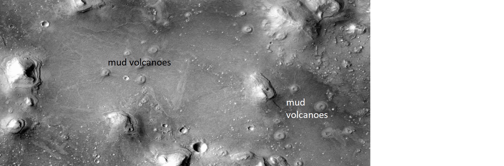
| 17:03, 19 March 2020 | FacectxD02 027892 2219pyramid.jpg (file) |  |
323 KB | Terrain near the face on Mars. Mud volcanoes are visible. Source: http://viewer.mars.asu.edu/planetview/inst/ctx/D02_027892_2219 Image credit: NASA/MSSS/Secosky | 1 |
| 17:01, 19 March 2020 | FaceG22 026771 2213 XI 41N009W.jpg (file) |  |
246 KB | Terrain to the west of the face on Mars. Source: http://viewer.mars.asu.edu/planetview/inst/ctx/G22_026771_2213_XI_41N009W Image credit: NASA/MSSS/Secosky | 1 |
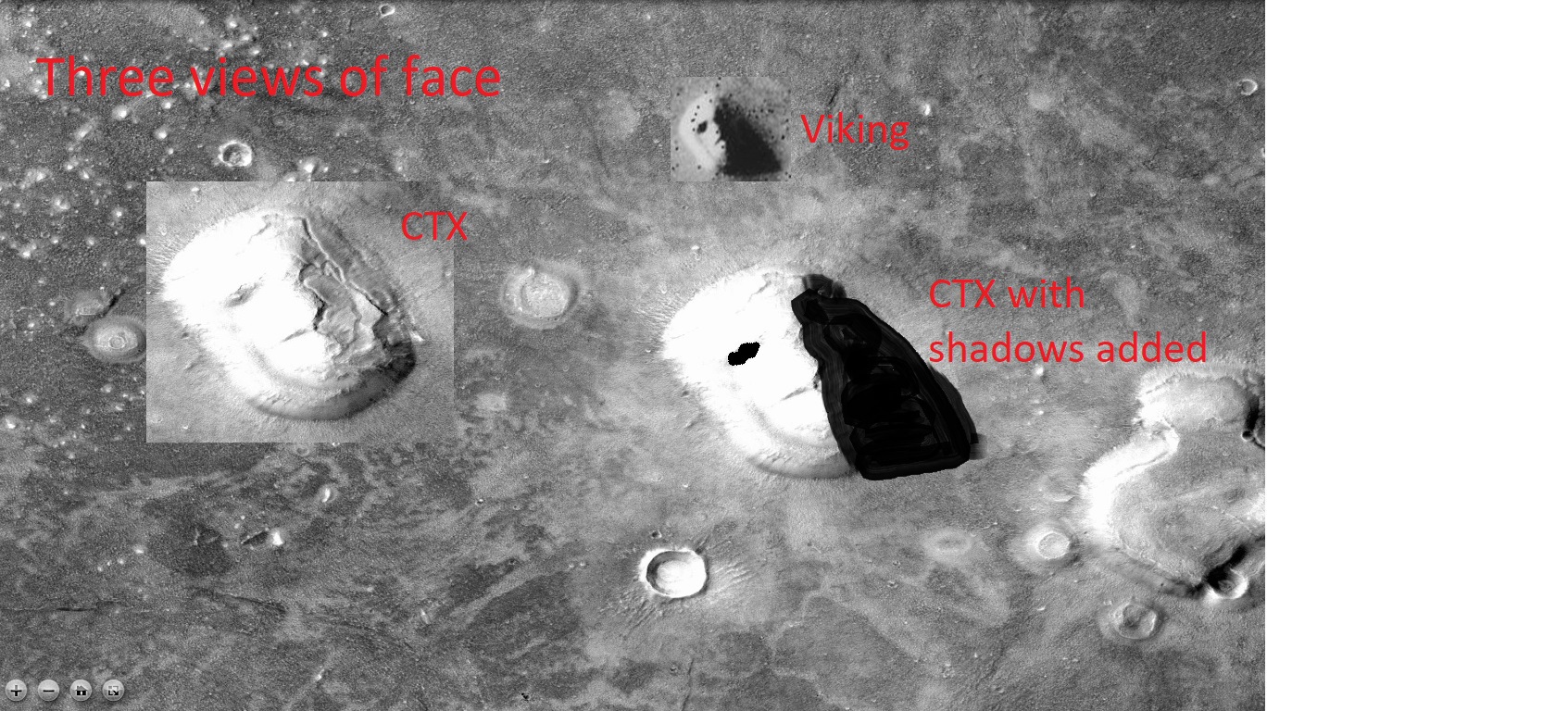
| 06:09, 19 March 2020 | PspfaceG22 026771 2213 XI 41N009Wctx.4threeviews.jpg (file) |  |
530 KB | Three views of famous face on Mars. One is the original from Viking. Two are from CTX on the MRO. One has half of face blackened to simulate effects of shadows. We could not see the whole face in the original. The half we could see did look like a face. Had we seen the whole face, we may not have thought it was a real face. Pictures were modified by Secosky. Source: PspfaceG22_026771_2213_XI_41N009Wctx Image Credit: NASA | 1 |


