Search results
Create the page "Maps" on this wiki! See also the search results found.
File:MGS MOC Wide Angle Map of Mars PIA03467.jpg ...relief maps, controlled photomosaics, and in a few cases albedo (shading) maps, mostly assembled from Mariner 9 survey images, with some gaps filled by Vi ...and various Mars Global Surveyor (MGS) Mars Orbiter Laser Altimeter (MOLA) maps have partially supplanted the ATLAS, it remains a standard desktop referenc(800 × 515 (55 KB)) - 08:10, 26 April 2018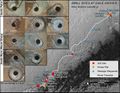
File:7858 mars-curiosity-rover-msl-drill-targets-samples-map-pia20748-full2.jpg This graphic maps locations of the first 14 sites where NASA's Curiosity Mars rover collected(1,600 × 1,236 (1.59 MB)) - 13:20, 29 December 2018


