Search results
Create the page "Rock" on this wiki! See also the search results found.
Page title matches
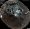
File:8148 mars-meteor-egg-rock-pia21133-full2.jpg Close view of "Egg Rock." small white spots are from laser hits that were used to classify the mete(1,169 × 1,154 (667 KB)) - 09:50, 29 December 2018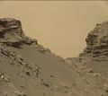
File:Mars-curiosity-rover-msl-rock-layers-PIA21042-full2.jpg Rock layers, as seen by Curiosity Rover View from Mastcam on Curiosity showing(1,344 × 1,200 (135 KB)) - 10:09, 29 December 2018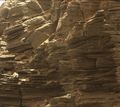
File:8021 mars-curiosity-rover-msl-rock-layers-PIA21043-full2murray.jpg (1,344 × 1,200 (216 KB)) - 10:01, 29 December 2018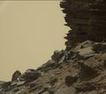
File:8023 mars-curiosity-rover-msl-rock-layers-PIA21045-full2murray.jpg (1,344 × 1,200 (135 KB)) - 10:07, 29 December 2018


Page text matches
File:Rollingstonesrock.jpg ...k is a little bigger than a golf ball, was later nicknamed "Rolling Stones Rock" in honor of The Rolling Stones Source: https://www.space.com/mars-rock-named-after-rolling-stones-nasa-insight-lander.html?utm_source=sdc-newslett(650 × 642 (88 KB)) - 16:10, 23 August 2019
File:AdirondackP2542 Sol14 L456-A16R1 br.jpg ...re better for examining a rock's top coating. Scientists named the angular rock after the Adirondack mountain range in New York. The word Adirondack is Nat(500 × 500 (80 KB)) - 17:34, 18 December 2018
File:MarsViking1Lander-BigJoeRock-19780211.jpg ...tists. The top of the rock is covered with red soil. Those portions of the rock not covered are similar in color to basaltic rocks on Earth. Therefore, thi(596 × 600 (29 KB)) - 10:40, 23 January 2019
File:Crew6 OrangePolka.jpg Orange rock with polka-dots(220 × 165 (24 KB)) - 17:03, 16 March 2020
File:Crew6 PookyPolkadot.jpg Pooky examines a polkadot rock(220 × 165 (24 KB)) - 16:41, 16 March 2020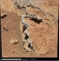
File:Image 9.jpg Jutting rock conglomeration in Gale Crater on Mars imaged by MSL’s Mastcam. (NASA)(807 × 831 (178 KB)) - 10:00, 18 December 2020
File:PIA01153 20594.jpg PIA01153_20594.jpg - Pathfinder site rock names(1,413 × 236 (113 KB)) - 22:30, 12 May 2007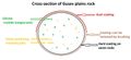
File:Rockgusevdiagram.jpg Diagram of a typical rock on Gusev plains(800 × 368 (34 KB)) - 09:02, 21 February 2018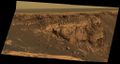
File:Sol1167B P2419 L257atc br2victoriacrater.jpg ...ions to solid bedrock. This transition point is marked by a bright band of rock, visible around the entire crater.(1,024 × 545 (88 KB)) - 17:41, 20 December 2018
File:6866 mars-curiosity-rover-mastcam-sedimentary-deposit-lakebed-rocks-pia19074-full2.jpg ...n Aug. 7, 2014. This is an example of a thick-laminated, evenly-stratified rock type that forms stratigraphically beneath cross-bedded sandstones regarded(983 × 718 (161 KB)) - 08:02, 3 April 2018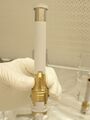
File:Sampletube26218 PIA24808.jpg ...tube like the one used to gather the first sample from Mars. It was from a rock called “Rochette.” ...tps://mars.nasa.gov/news/9029/nasas-perseverance-rover-collects-first-mars-rock-sample/(1,600 × 2,133 (251 KB)) - 08:30, 21 September 2021
File:Voids on bedrock on Mars.jpg Voids in rock Large crystals formed and then they dissolved away and left voids of where(500 × 374 (61 KB)) - 15:44, 20 December 2018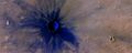
File:ESP 011425 1775newcrater.jpg ...esents the dark surface that lies under the dust. It is the dark volcanic rock basalt.(1,680 × 666 (1.18 MB)) - 05:57, 17 April 2020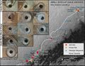
File:7858 mars-curiosity-rover-msl-drill-targets-samples-map-pia20748-full2.jpg ...inside the vehicle. It also presents images of the drilled holes where 12 rock-powder samples were acquired. At the other two sites -- Rocknest and Gobabe Dates when the first 11 drilled-rock samples were collected are: "John Klein" on Feb. 8, 2013 (Sol 182); "Cumber(1,600 × 1,236 (1.59 MB)) - 13:20, 29 December 2018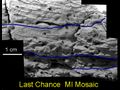
File:LastChance D JG03-B058R1 br.jpg ...pretations of cross-lamination patterns presented as clues to this martian rock's (nicknamed "Last Chance") origin under flowing water are marked on images(720 × 540 (229 KB)) - 16:09, 20 December 2018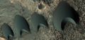
File:55095 2170dunelinecolor.jpg ...ISE under HiWish program Dark color is from dark minerals in the volcanic rock called basalt.(1,307 × 618 (254 KB)) - 08:38, 22 October 2018File:8148 mars-meteor-egg-rock-pia21133-full2.jpg Close view of "Egg Rock." small white spots are from laser hits that were used to classify the mete(1,169 × 1,154 (667 KB)) - 09:50, 29 December 2018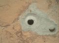
File:5073 pia16726-full2john.jpg At the center of this image from NASA's Curiosity rover is the hole in a rock called "John Klein" where the rover conducted its first sample drilling on The rock Curiosity drilled is called "John Klein" in memory of a Mars Science Labora(967 × 707 (129 KB)) - 16:32, 28 December 2018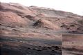
File:PIA16105 malin04ano-br2.jpg ...The pointy mound in the center of the image, looming above the rover-sized rock, is about 1,000 feet (300 meters) across and 300 feet (100 meters) high.(800 × 534 (111 KB)) - 09:44, 15 November 2018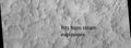
File:ESP 012531 1435pits.jpg ...floor of Hale crater from steam explosions, as seen by HiRISE Hot molted rock fell after impact and caused steam explosions in the ice rich ground.(1,507 × 555 (304 KB)) - 08:07, 18 April 2020


