Difference between revisions of "File:Meandering Ridges.JPG"
(Meandering Ridges, as seen by hirise. Location is 5.4 degrees south latitude and 154.6 degrees east longitude. Image was taken by the Mars Reconnaissance Orbiter's HiRISE. The HiRISE camera was built by Ball Aerospace and Technology Corporation and is...) |
(No difference)
|
Latest revision as of 15:45, 25 January 2019
Summary
Meandering Ridges, as seen by hirise. Location is 5.4 degrees south latitude and 154.6 degrees east longitude. Image was taken by the Mars Reconnaissance Orbiter's HiRISE. The HiRISE camera was built by Ball Aerospace and Technology Corporation and is operated by the University of Arizona.
Image courtesy NASA/JPL/University of Arizona.
Source http://hirise.lpl.arizona.edu/PSP_007474_1745
Licensing
Public domain images are available for anybody to use without any licenses, royalties, or special permissions.
File history
Click on a date/time to view the file as it appeared at that time.
| Date/Time | Thumbnail | Dimensions | User | Comment | |
|---|---|---|---|---|---|
| current | 15:45, 25 January 2019 | 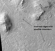 | 190 × 175 (10 KB) | Suitupandshowup (talk | contribs) | Meandering Ridges, as seen by hirise. Location is 5.4 degrees south latitude and 154.6 degrees east longitude. Image was taken by the Mars Reconnaissance Orbiter's HiRISE. The HiRISE camera was built by Ball Aerospace and Technology Corporation and is... |
You cannot overwrite this file.
File usage
The following page uses this file:


