
File:PIA00171-MC-11-OxiaPalusRegion-19980605.jpg: Difference between revisions
Picture of Oxia Palus region Many craters and other features are labeled Converted the original PDF file to a PNG File (via GIMP v2.8.4 program) - and uploaded to Wikimedia Commons. Date 05/06/2013 12:24:02 Source http://planetarynames.wr.usgs.gov/im... |
m →Summary |
||
| (One intermediate revision by the same user not shown) | |||
| Line 1: | Line 1: | ||
== Summary == | == Summary == | ||
Picture of Oxia Palus region Many craters and other features are labeled | Picture of Oxia Palus region Many craters and other features are labeled | ||
Mars digital-image mosaic merged with color of the MC-11 quadrangle, Oxia Palus region of Mars. Heavily cratered highlands of the southeastern two-thirds are cut by several large outflow channels. These channels terminate at the dark large depression, Chryse basin, which contain relatively smooth plains in the northwestern part. Latitude range 0 to 30 degrees, longitude range 0 to 45 degrees. | |||
Converted the original PDF file to a PNG File (via GIMP v2.8.4 program) - and uploaded to Wikimedia Commons. | Converted the original PDF file to a PNG File (via GIMP v2.8.4 program) - and uploaded to Wikimedia Commons. | ||
Date 05/06/2013 12:24:02 | Date 05/06/2013 12:24:02 | ||
Source http://planetarynames.wr.usgs.gov/images/mc11_mola.pdf | Source http://planetarynames.wr.usgs.gov/images/mc11_mola.pdf For more information about names and locations on Mars go to https://planetarynames.wr.usgs.gov/ | ||
Image credit: USGS (United States Geological Survey)/Secosky | Image credit: USGS (United States Geological Survey)/Secosky | ||
== Licensing == | == Licensing == | ||
{{GPL}} | {{GPL}} | ||


Latest revision as of 21:16, 20 August 2020
Summary
Picture of Oxia Palus region Many craters and other features are labeled
Mars digital-image mosaic merged with color of the MC-11 quadrangle, Oxia Palus region of Mars. Heavily cratered highlands of the southeastern two-thirds are cut by several large outflow channels. These channels terminate at the dark large depression, Chryse basin, which contain relatively smooth plains in the northwestern part. Latitude range 0 to 30 degrees, longitude range 0 to 45 degrees.
Converted the original PDF file to a PNG File (via GIMP v2.8.4 program) - and uploaded to Wikimedia Commons. Date 05/06/2013 12:24:02 Source http://planetarynames.wr.usgs.gov/images/mc11_mola.pdf For more information about names and locations on Mars go to https://planetarynames.wr.usgs.gov/
Image credit: USGS (United States Geological Survey)/Secosky
Licensing
GNU General Public License (License Text)
File history
Click on a date/time to view the file as it appeared at that time.
| Date/Time | Thumbnail | Dimensions | User | Comment | |
|---|---|---|---|---|---|
| current | 18:06, 17 January 2019 | 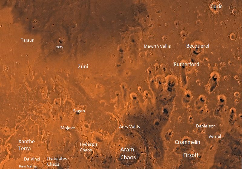 | 800 × 557 (155 KB) | Suitupandshowup (talk | contribs) | Picture of Oxia Palus region Many craters and other features are labeled Converted the original PDF file to a PNG File (via GIMP v2.8.4 program) - and uploaded to Wikimedia Commons. Date 05/06/2013 12:24:02 Source http://planetarynames.wr.usgs.gov/im... |
You cannot overwrite this file.
File usage
The following page uses this file:
