File:Canyons and Mesas of Aureum Chaos in Oxia Palus.JPG
Revision as of 19:40, 28 January 2019 by Suitupandshowup (talk | contribs) (Canyons and Mesas of Aureum Chaos in Oxia Palus. Loacation is 1.6 degrees south latitude and 26.8 degrees west longitude. This picture was taken by the Mars 2001 Odyssey Thermal Emission Imaging System (THEMIS). The picture credit is NASA/JPL/Arizona...)
Error creating thumbnail: Unable to save thumbnail to destination
No higher resolution available.
Canyons_and_Mesas_of_Aureum_Chaos_in_Oxia_Palus.JPG (458 × 480 pixels, file size: 37 KB, MIME type: image/jpeg)
Summary
Canyons and Mesas of Aureum Chaos in Oxia Palus. Loacation is 1.6 degrees south latitude and 26.8 degrees west longitude. This picture was taken by the Mars 2001 Odyssey Thermal Emission Imaging System (THEMIS).
The picture credit is NASA/JPL/Arizona State University.
Source http://thermis.la.asu.edu/zoom-20020617a.html
Licensing
Public domain images are available for anybody to use without any licenses, royalties, or special permissions.
File history
Click on a date/time to view the file as it appeared at that time.
| Date/Time | Thumbnail | Dimensions | User | Comment | |
|---|---|---|---|---|---|
| current | 19:40, 28 January 2019 | 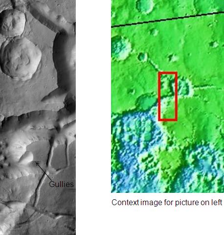 | 458 × 480 (37 KB) | Suitupandshowup (talk | contribs) | Canyons and Mesas of Aureum Chaos in Oxia Palus. Loacation is 1.6 degrees south latitude and 26.8 degrees west longitude. This picture was taken by the Mars 2001 Odyssey Thermal Emission Imaging System (THEMIS). The picture credit is NASA/JPL/Arizona... |
You cannot overwrite this file.
File usage
The following file is a duplicate of this file (more details):
- File:Canyons and Mesas of Aureum Chaos in Oxia Palus.JPG from Wikimedia Commons
The following page uses this file:


