File:Detail of Maja Valles Flow.jpg
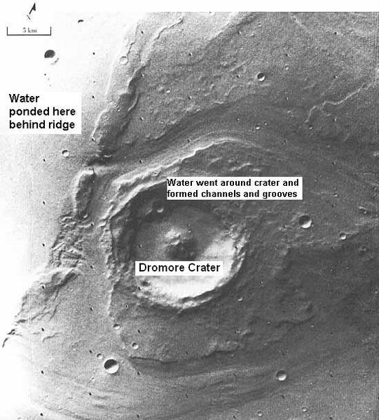
Revision as of 14:42, 3 November 2018 by Suitupandshowup (talk | contribs) (Detail of water flow around Dromore crater within the ouflow channel Maja Valles, as seen by Viking 1. Location is 20N and 49 W. Source http://history.nass.gov/SP-414/ch4.htm Image credit: NASA/Secosky)

Size of this preview: 541 × 599 pixels. Other resolution: 217 × 240 pixels.
Original file (549 × 608 pixels, file size: 70 KB, MIME type: image/jpeg)
Summary
Detail of water flow around Dromore crater within the ouflow channel Maja Valles, as seen by Viking 1. Location is 20N and 49 W.
Source http://history.nass.gov/SP-414/ch4.htm Image credit: NASA/Secosky
Licensing
Public domain images are available for anybody to use without any licenses, royalties, or special permissions.
File history
Click on a date/time to view the file as it appeared at that time.
| Date/Time | Thumbnail | Dimensions | User | Comment | |
|---|---|---|---|---|---|
| current | 14:42, 3 November 2018 | | 549 × 608 (70 KB) | Suitupandshowup (talk | contribs) | Detail of water flow around Dromore crater within the ouflow channel Maja Valles, as seen by Viking 1. Location is 20N and 49 W. Source http://history.nass.gov/SP-414/ch4.htm Image credit: NASA/Secosky |
You cannot overwrite this file.
File usage
The following file is a duplicate of this file (more details):
- File:Detail of Maja Valles Flow.jpg from Wikimedia Commons
The following 3 pages use this file:


