Difference between revisions of "High Resolution Imaging Science Experiment (HiRISE)"
(→Examples of HiRISE images: added image) |
Suitupshowup (talk | contribs) (→External links: added link) |
||
| (17 intermediate revisions by 2 users not shown) | |||
| Line 5: | Line 5: | ||
High Resolution Imaging Science Experiment is a camera on board the [[Mars Reconnaissance Orbiter]]. Ball Aerospace & Technologies Corp., under the direction of the University of Arizona's Lunar and Planetary Laboratory built the 0.5 m (19.7 in) diameter reflecting telescope.<ref name="Ref_l">[http://cat.inist.fr/?aModele=afficheN&cpsidt=20649610 Mission to Mars: the HiRISE camera on-board MRO], ''Focal plane arrays for space telescopes III,'' 27–28 August 2007, San Diego, California, USA</ref> It is the largest telescope to study Mars from orbit. Most of the time, HiRISE has orbited the planet in a nearly circular orbit to approximately 250 miles (316 Km) above the Martian surface, with a period of about 112 minutes.<ref>https://mars.jpl.nasa.gov/mro/newsroom/pressreleases/20060912a.html</ref> <ref>https://www.webcitation.org/6EE9oKZFn?url=http://airandspace.si.edu/research/ceps/cepsicons/highlights/fact_sheet_front.pdf</ref> At this altitude it can take pictures of Mars with resolutions of 0.3 m/pixel (about 1 foot); hence it resolves objects less than a meter across. HiRISE is so powerful that it was able to spot Mars landers on the surface, including the ongoing Curiosity and Opportunity.<ref name=voa>[http://www.voanews.com/english/news/science-technology/Mars-Orbiter-Photographs-Old-NASA-Landers-139039139.html VOA News - Mars Orbiter Photographs Old NASA Lander (February 9, 2012)]</ref> <ref>McEwen, A., et al. 2007. Mars Reconnaissance Orbiter's High Resolution Imaging Science Experiment (HiRISE). Journal of Geophysical Research: Planets Volume 112, Issue E5</ref> <ref>https://agupubs.onlinelibrary.wiley.com/doi/full/10.1029/2005JE002605</ref> | High Resolution Imaging Science Experiment is a camera on board the [[Mars Reconnaissance Orbiter]]. Ball Aerospace & Technologies Corp., under the direction of the University of Arizona's Lunar and Planetary Laboratory built the 0.5 m (19.7 in) diameter reflecting telescope.<ref name="Ref_l">[http://cat.inist.fr/?aModele=afficheN&cpsidt=20649610 Mission to Mars: the HiRISE camera on-board MRO], ''Focal plane arrays for space telescopes III,'' 27–28 August 2007, San Diego, California, USA</ref> It is the largest telescope to study Mars from orbit. Most of the time, HiRISE has orbited the planet in a nearly circular orbit to approximately 250 miles (316 Km) above the Martian surface, with a period of about 112 minutes.<ref>https://mars.jpl.nasa.gov/mro/newsroom/pressreleases/20060912a.html</ref> <ref>https://www.webcitation.org/6EE9oKZFn?url=http://airandspace.si.edu/research/ceps/cepsicons/highlights/fact_sheet_front.pdf</ref> At this altitude it can take pictures of Mars with resolutions of 0.3 m/pixel (about 1 foot); hence it resolves objects less than a meter across. HiRISE is so powerful that it was able to spot Mars landers on the surface, including the ongoing Curiosity and Opportunity.<ref name=voa>[http://www.voanews.com/english/news/science-technology/Mars-Orbiter-Photographs-Old-NASA-Landers-139039139.html VOA News - Mars Orbiter Photographs Old NASA Lander (February 9, 2012)]</ref> <ref>McEwen, A., et al. 2007. Mars Reconnaissance Orbiter's High Resolution Imaging Science Experiment (HiRISE). Journal of Geophysical Research: Planets Volume 112, Issue E5</ref> <ref>https://agupubs.onlinelibrary.wiley.com/doi/full/10.1029/2005JE002605</ref> | ||
| − | <gallery class="center" widths=" | + | |
| + | <gallery class="center" widths="380px" heights="360px"> | ||
File:Fall36camerascomparedwidthslabeled.jpg|HiRISE images are 5 km wide and can be of various lengths. HiRISE is far more powerful than the camera on Mars Global Surveyor (MGS) | File:Fall36camerascomparedwidthslabeled.jpg|HiRISE images are 5 km wide and can be of various lengths. HiRISE is far more powerful than the camera on Mars Global Surveyor (MGS) | ||
</gallery> | </gallery> | ||
| − | <gallery class="center" widths=" | + | |
| + | <gallery class="center" widths="380px" heights="360px"> | ||
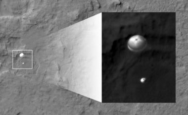
File:Phoenix with a crater in the background taken by Mars Reconnaissance Orbiter.jpg|Phoenix lander descending to surface | File:Phoenix with a crater in the background taken by Mars Reconnaissance Orbiter.jpg|Phoenix lander descending to surface | ||
| Line 15: | Line 17: | ||
File:Opportunity Rover by HiRISE.jpg| Opportunity Rover on its way to Endeavour Crater | File:Opportunity Rover by HiRISE.jpg| Opportunity Rover on its way to Endeavour Crater | ||
File:MRO sees Curiosity landing.jpg|Curiosity Rover descending to surface with parachute | File:MRO sees Curiosity landing.jpg|Curiosity Rover descending to surface with parachute | ||
| + | |||
| + | File:ZhurongChina.jpg|Zhurong, as seen by HiRISE. It's tracks are indicated with blue arrow.China's Zhurong lander is only about the size of a small car, yet HiRISE can see it and its tracks. | ||
</gallery> | </gallery> | ||
| + | |||
Launched on August 12, 2005 by an Atlas V rocket from Cape Canaveral Air Force Station, the Mars Reconnaissance Orbiter (MRO) carrying HiRISE and other instruments arrived at Mars on March 10, 2006. However, it did not begin its main picture taking until November 2006. It began gathering data in November 2006 after completion of a long aerobreaking maneuver in the upper Mars atmosphere to place it in the desired orbit. The orbit has an inclination of 93 degrees, which means it orbits north and south in a polar orbit, as the planet turns beneath it.<ref> Lyons, Daniel T. (August 5–8, 2002). "MARS RECONNAISSANCE ORBITER: AEROBRAKING REFERENCE TRAJECTORY" (PDF). AIAA/AAS Astrodynamics Specialist Conference and Exhibit. Archived from the original (PDF) on October 18, 2011. Retrieved March 9, 2012.</ref> As a result of the characteristics of its orbit, HiRISE takes pictures at about 3 p.m. local time. This time frame produces few shadows, but does avoid morning mist. To arrange for communications support during the arrival of the [[InSight Mission]], a new Mars lander mission, the orbit was slightly modified on September 28, 2016 by a 75 second engine burn.<ref>[http://www.nasa.gov/jpl/mro/nasa-mars-orbiter-preparing-for-mars-landers-2016-arrival NASA Mars Orbiter Preparing for Mars Lander's 2016 Arrival]</ref> <ref>[http://www.gizmag.com/mars-orbiter-prepares-for-new-arrival/38665/ Mars orbiter prepares for next year's InSight lander arrival]. July 29, 2015.</ref> | Launched on August 12, 2005 by an Atlas V rocket from Cape Canaveral Air Force Station, the Mars Reconnaissance Orbiter (MRO) carrying HiRISE and other instruments arrived at Mars on March 10, 2006. However, it did not begin its main picture taking until November 2006. It began gathering data in November 2006 after completion of a long aerobreaking maneuver in the upper Mars atmosphere to place it in the desired orbit. The orbit has an inclination of 93 degrees, which means it orbits north and south in a polar orbit, as the planet turns beneath it.<ref> Lyons, Daniel T. (August 5–8, 2002). "MARS RECONNAISSANCE ORBITER: AEROBRAKING REFERENCE TRAJECTORY" (PDF). AIAA/AAS Astrodynamics Specialist Conference and Exhibit. Archived from the original (PDF) on October 18, 2011. Retrieved March 9, 2012.</ref> As a result of the characteristics of its orbit, HiRISE takes pictures at about 3 p.m. local time. This time frame produces few shadows, but does avoid morning mist. To arrange for communications support during the arrival of the [[InSight Mission]], a new Mars lander mission, the orbit was slightly modified on September 28, 2016 by a 75 second engine burn.<ref>[http://www.nasa.gov/jpl/mro/nasa-mars-orbiter-preparing-for-mars-landers-2016-arrival NASA Mars Orbiter Preparing for Mars Lander's 2016 Arrival]</ref> <ref>[http://www.gizmag.com/mars-orbiter-prepares-for-new-arrival/38665/ Mars orbiter prepares for next year's InSight lander arrival]. July 29, 2015.</ref> | ||
| Line 24: | Line 29: | ||
The following group of images shows some significant images taken by the instrument. Some of them hint at possible sources of water for future colonists. | The following group of images shows some significant images taken by the instrument. Some of them hint at possible sources of water for future colonists. | ||
| − | <gallery widths=" | + | |
| + | <gallery class="center" widths="380px" heights="360px"> | ||
File:ESP 046359 1250-2pingoscale.jpg|Close view of possible pingo with scale, as seen by HiRISE under HiWish program Pingos may contain a core of pure ice. | File:ESP 046359 1250-2pingoscale.jpg|Close view of possible pingo with scale, as seen by HiRISE under HiWish program Pingos may contain a core of pure ice. | ||
File:46444 2225mantle.jpg| Close view of mantle Mantle may be used as a water source by future colonists. | File:46444 2225mantle.jpg| Close view of mantle Mantle may be used as a water source by future colonists. | ||
| Line 39: | Line 45: | ||
Most pictures from spacecraft have some sort of enhancement. For many views of Mars there is not much contrast so the contrast is enhanced in a process known as stretching. The darkest parts are set to black while the lightest parts are set to be white. As a result of this process, many features appear much darker. Much of Mars is covered by a brown/red dust that gives little contrast. Pictures would be very bland. | Most pictures from spacecraft have some sort of enhancement. For many views of Mars there is not much contrast so the contrast is enhanced in a process known as stretching. The darkest parts are set to black while the lightest parts are set to be white. As a result of this process, many features appear much darker. Much of Mars is covered by a brown/red dust that gives little contrast. Pictures would be very bland. | ||
| − | The colors for HiRISE images are different than the human eye would see. HiRISE only sees in 3 colors and sometimes infrared is used rather than red. Displaying colors in this way allows us to better identify rocks and minerals. Usually, color images are constructed in one of two ways. An IRB image assigns the output from the infrared channel to the color red, the wide red channel to the color green, and the blue-green channel to the color blue. On the other hand, a RGB image has the output of the broad red channel displayed as red, the blue-green channel as green, and a synthetic blue channel (blue-green minus part of the red) as blue. The wavelengths of these channels are: RED: 570-830 nanometers BG: <580 nanometers IR: >790 nanometers. One nanometer is equal to one billionth of a metre (0.000 000 001 m). <ref> https://www.uahirise.org/faq/#Colors</ref> <ref> https://en.wikipedia.org/wiki/Nanometre</ref> | + | |
| + | The following back and white image is used to show the difference in colors--depending on how the image is processed. | ||
| + | |||
| + | |||
| + | [[File:61974 1710duneswide.jpg|Wide view of a group of dunes taken just in black and white, as taken under HiWish program|600pxr|Wide view of a group of dunes taken just in black and white]] | ||
| + | |||
| + | Wide view of a group of dunes taken just in black and white | ||
| + | |||
| + | The colors for HiRISE images are different than the human eye would see. HiRISE only sees in 3 colors and sometimes infrared is used rather than red. Displaying colors in this way allows us to better identify rocks and minerals. Redder colors usually mean more dust is present, on the other hand bluer colors may show coarser-grained rocks and/or more ferrous minerals such as olivine, pyroxene.<ref>Bergstrom, N.T. Bridges, E.M. Eliason, D. Gallagher, K.E. Herkenhoff, L. Keszthelyi, S. Mattson, G.K. McArthur, M.T. Mellon, M. Milazzo, P.S. Russell, N. Thomas | ||
| + | Color imaging of Mars by the high resolution imaging science experiment (HiRISE) | ||
| + | Icarus, 205 (2010), pp. 38-52, 10.1016/j.icarus.2009.03.012</ref> Usually, color images are constructed in one of two ways. An IRB image assigns the output from the infrared channel to the color red, the wide red channel to the color green, and the blue-green channel to the color blue. The picture below shows part of the black and white photo processed in IRB. | ||
| + | |||
| + | [[File:61974 1710dunesirb3.jpg|Dune processed in infrared, red, and green (IRB)|600pxr|Dune processed in infrared, red, and green (IRB)]] | ||
| + | |||
| + | Dune processed in infrared, red, and green (IRB) | ||
| + | |||
| + | |||
| + | |||
| + | On the other hand, a RGB image has the output of the broad red channel displayed as red, the blue-green channel as green, and a synthetic blue channel (blue-green minus part of the red) as blue. The wavelengths of these channels are: RED: 570-830 nanometers BG: <580 nanometers IR: >790 nanometers. One nanometer is equal to one billionth of a metre (0.000 000 001 m). <ref> https://www.uahirise.org/faq/#Colors</ref> <ref> https://en.wikipedia.org/wiki/Nanometre</ref> | ||
| + | |||
| + | |||
| + | [[File:61974 1710dunesrgb.jpg|Dune processed in the red, green, blue (RGB) channels|600pxr|Dune processed in red, green, blue (RGB)]] | ||
| + | |||
| + | Dune processed in the red, green, blue (RGB) channels | ||
| + | |||
| + | [[File:ESP 013784 1710Valles Marineriswide.jpg|thumb|300px|left|Black and white image of layers in south wall of Valles Marineris Wall shows many layers; some are from lava flows.]] | ||
| + | |||
| + | [[File:ESP 013784 1710Valles Marineriscolors.jpg|thumb|300px|right|Color image of part of south wall of Valles Marineris, as seen by HiRISE. Different minerals produce different colors.]] | ||
| + | |||
HiRISE images are about 5 km wide with a 1 km wide band in the center that is in color.<ref>McEwen, A., et al. 2017. Mars The Prestine Beauty of the Red Planet. University of Arizona Press. Tucson</ref> | HiRISE images are about 5 km wide with a 1 km wide band in the center that is in color.<ref>McEwen, A., et al. 2017. Mars The Prestine Beauty of the Red Planet. University of Arizona Press. Tucson</ref> | ||
Red color images are at 20,048 pixels wide (6 km in a 300 km orbit), and blue-green and NIR are at 4,048 pixels wide (1.2 km). These are gathered by 14 CCD sensors. HiRISE's onboard computer reads out lines of pixels in time with the orbiter's ground speed; consequently, pictures are potentially unlimited in height. However, height is restricted by the onboard computer's 28 Gigabit (3.5 GByte) memory capacity. The typical maximum size of red images (compressed to 8 bits per pixel) is about 20,000 times 126,000 pixels, or 2520 megapixels and 4,000 times 126,000 pixels (504 megapixels) for the narrower images of the B-G and NIR bands. A single uncompressed image uses up to 28 Gb. However, these images are transmitted compressed, with the usual size being 11.2 Gigabits. These images are released to the general public on the HiRISE website via a new format called JPEG 2000.<ref name="Ref_m">cite web |url=http://marsoweb.nas.nasa.gov/HiRISE/papers/6th_int_mars_conf/Delamere_HiRISE_InstDev.pdf |title=HiRISE: Instrument Development |work=NASA Ames Research Center website |accessdate=7 February 2006 |format=PDF</ref> <ref name="Ref_n">cite web |url=http://www.nasm.si.edu/research/ceps/cepsicons/highlights/fact_sheet_front.pdf |title=Fact Sheet: HiRISE |work=National Air and Space Museum |accessdate=18 February 2006 |format=PDF |deadurl=yes |archiveurl=https://www.webcitation.org/6EE9oKZFn?url=http://airandspace.si.edu/research/ceps/cepsicons/highlights/fact_sheet_front.pdf |archivedate=6 February 2013 </ref> The full image includes a scale bar of 500 or 1000 meter length. | Red color images are at 20,048 pixels wide (6 km in a 300 km orbit), and blue-green and NIR are at 4,048 pixels wide (1.2 km). These are gathered by 14 CCD sensors. HiRISE's onboard computer reads out lines of pixels in time with the orbiter's ground speed; consequently, pictures are potentially unlimited in height. However, height is restricted by the onboard computer's 28 Gigabit (3.5 GByte) memory capacity. The typical maximum size of red images (compressed to 8 bits per pixel) is about 20,000 times 126,000 pixels, or 2520 megapixels and 4,000 times 126,000 pixels (504 megapixels) for the narrower images of the B-G and NIR bands. A single uncompressed image uses up to 28 Gb. However, these images are transmitted compressed, with the usual size being 11.2 Gigabits. These images are released to the general public on the HiRISE website via a new format called JPEG 2000.<ref name="Ref_m">cite web |url=http://marsoweb.nas.nasa.gov/HiRISE/papers/6th_int_mars_conf/Delamere_HiRISE_InstDev.pdf |title=HiRISE: Instrument Development |work=NASA Ames Research Center website |accessdate=7 February 2006 |format=PDF</ref> <ref name="Ref_n">cite web |url=http://www.nasm.si.edu/research/ceps/cepsicons/highlights/fact_sheet_front.pdf |title=Fact Sheet: HiRISE |work=National Air and Space Museum |accessdate=18 February 2006 |format=PDF |deadurl=yes |archiveurl=https://www.webcitation.org/6EE9oKZFn?url=http://airandspace.si.edu/research/ceps/cepsicons/highlights/fact_sheet_front.pdf |archivedate=6 February 2013 </ref> The full image includes a scale bar of 500 or 1000 meter length. | ||
| Line 45: | Line 79: | ||
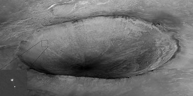
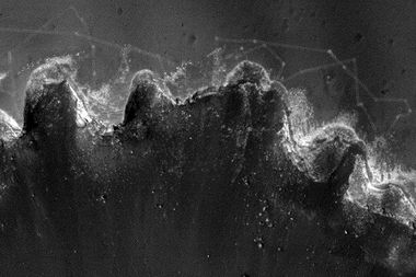
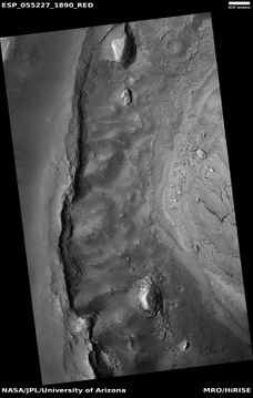
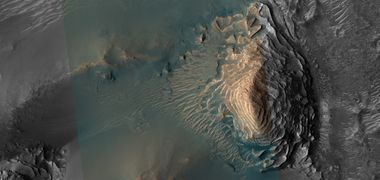
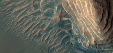
The following set of pictures show first a full image of a scene and then enlargements from parts of it. A program called HiView can be used to produce more detailed views. Some pictures are in color. HiRISE takes a color strip down the middle only. | The following set of pictures show first a full image of a scene and then enlargements from parts of it. A program called HiView can be used to produce more detailed views. Some pictures are in color. HiRISE takes a color strip down the middle only. | ||
| − | <gallery class="center" widths=" | + | |
| + | <gallery class="center" widths="380px" heights="360px"> | ||
File:ESP 055227 1890layeredmound.jpg|Wide view of layers Parts of this image are enlarged in the following images. The scale bar at the top is 500 meters long. | File:ESP 055227 1890layeredmound.jpg|Wide view of layers Parts of this image are enlarged in the following images. The scale bar at the top is 500 meters long. | ||
File:55227 1890layeredmoundwide.jpg|Enlarged view using HiView of mound Only part of the picture is in color because HiRISE only images an center strip in color. | File:55227 1890layeredmoundwide.jpg|Enlarged view using HiView of mound Only part of the picture is in color because HiRISE only images an center strip in color. | ||
| Line 59: | Line 94: | ||
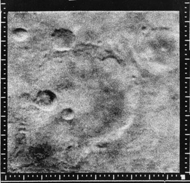
HiRISE is basically a telescope in a low orbit around Mars; consequently, it can provide unbelievable views of the Martian surface. It is far better than all the other cameras that have gone there to look at the planet. This section displays pictures from a variety of cameras on past spacecraft. | HiRISE is basically a telescope in a low orbit around Mars; consequently, it can provide unbelievable views of the Martian surface. It is far better than all the other cameras that have gone there to look at the planet. This section displays pictures from a variety of cameras on past spacecraft. | ||
| − | <gallery class="center" widths=" | + | |
| + | <gallery class="center" widths="380px" heights="360px"> | ||
File:Mars m04 11emarinercraterfrom mariner4.jpg |Mariner Crater, as seen by ''Mariner 4''. This may be the best picture that our first spacecraft to fly by Mars took. Image located in Phaethontis quadrangle. | File:Mars m04 11emarinercraterfrom mariner4.jpg |Mariner Crater, as seen by ''Mariner 4''. This may be the best picture that our first spacecraft to fly by Mars took. Image located in Phaethontis quadrangle. | ||
| Line 76: | Line 112: | ||
The next two images compare pictures taken with 7 different cameras. HiRISE clearly has the best view of the surface. | The next two images compare pictures taken with 7 different cameras. HiRISE clearly has the best view of the surface. | ||
| − | <gallery class="center" widths=" | + | |
| + | <gallery class="center" widths="380px" heights="360px"> | ||
ESP 052438 1560-1differentspacecraftpicturesarrows.jpg|Wide view of portion of Memnonia quadrangle Arrows show locations of images from various cameras. The images from these cameras are shown in the following image. The 7 cameras are HiRISE (Mars Reconnaissance Orbiter), THEMIS VIS (Mars Odyssey), MOC-WAC (Mars Global Surveyor), HRSC (Mars Express), CTX (''Mars Reconnaissance Orbiter''), Viking, Mariner 4. | ESP 052438 1560-1differentspacecraftpicturesarrows.jpg|Wide view of portion of Memnonia quadrangle Arrows show locations of images from various cameras. The images from these cameras are shown in the following image. The 7 cameras are HiRISE (Mars Reconnaissance Orbiter), THEMIS VIS (Mars Odyssey), MOC-WAC (Mars Global Surveyor), HRSC (Mars Express), CTX (''Mars Reconnaissance Orbiter''), Viking, Mariner 4. | ||
| Line 85: | Line 122: | ||
==Results== | ==Results== | ||
| − | As of March 9, 2016, the 10 year Anniversary of MRO, over 2.4 % of the surface has been examined by HiRISE. That is about the area of two Alaska’s. More would have been looked at, but many places were imaged multiple times to look for changes in things like sand dunes, gullies, and streaks. Pictures could contain up to 28 gigabits (Gb) of data. The highly successful mission of Mariner 9 changed many of our ideas about the Red Planet, yet it returned only 7,329 images with a total of 40 Gb of data, according to the final report. <ref> Techinical Report 32-1550. Volume III. Mariner Mars 1971 Project Final Report.</ref> <ref>https://ntrs.nasa.gov/archive/nasa/casi.ntrs.nasa.gov/19730018117.pdf</ref> So just 2 HiRISE images may contain more than the entire Mariner 9 mission. At the time of this writing ( | + | As of March 9, 2016, the 10 year Anniversary of MRO, over 2.4 % of the surface has been examined by HiRISE. That is about the area of two Alaska’s. More would have been looked at, but many places were imaged multiple times to look for changes in things like sand dunes, gullies, and streaks. Pictures could contain up to 28 gigabits (Gb) of data. The highly successful mission of Mariner 9 changed many of our ideas about the Red Planet, yet it returned only 7,329 images with a total of 40 Gb of data, according to the final report. <ref> Techinical Report 32-1550. Volume III. Mariner Mars 1971 Project Final Report.</ref> <ref>https://ntrs.nasa.gov/archive/nasa/casi.ntrs.nasa.gov/19730018117.pdf</ref> So just 2 HiRISE images may contain more than the entire Mariner 9 mission. At the time of this writing (8/14/20, HiRISE had taken 6,882,204 images, generating 194 terabytes of data sent from Mars since 2006.<ref>https://outlook.live.com/mail/0/inbox/id/AQMkADAwATExAGNiNy00YzQ1LTM4MjMtMDACLTAwCgBGAAADdsmEa%2FgtIEmBK%2FX8yb671wcAkr%2FaXi2mwEKimhNbcs0</ref> On another note, the first image sent from Mars by Mariner 4 in the summer of 1965 only contained 240,000 bits.<ref>Leighton, R. 1970. The Surface of Mars. Scientific American: 222, 26-41</ref> One HiRISE image could contain 16,666 times as many bits as that Mariner image. |
| + | One of the most amazing feats done with HiRISE was capturing dust clouds that were caused by blocks of ice tumbling down cliffs in the North Polar Layered Deposits.<ref>https://www.uahirise.org/ESP_060176_2640</ref> | ||
| + | |||
| + | [[File:ESP 060176 2640avalanche.jpg|Wide view of dust clouds being produced when ice chunks fall down cliffs|600pxr|Wide view of dust clouds being produced when ice chunks fall down cliffs]] | ||
| + | Wide view of dust clouds being produced when ice chunks fall down cliffs | ||
| + | |||
| + | |||
| + | [[File:ESP 060176 2640dustavalanche.jpg|Dust clouds from ice chunks falling down cliffs|600pxr|Dust clouds from ice chunks falling down cliffs]] | ||
| + | |||
| + | Dust clouds from ice chunks falling down cliffs | ||
==How to view images== | ==How to view images== | ||
| Line 93: | Line 139: | ||
| − | <gallery class="center" widths=" | + | |
| + | <gallery class="center" widths="380px" heights="360px"> | ||
File:PSP 005837 1965cratercolor.jpg|Digital Terrain Model of crater showing topography with different colors | File:PSP 005837 1965cratercolor.jpg|Digital Terrain Model of crater showing topography with different colors | ||
</gallery> | </gallery> | ||
| Line 103: | Line 150: | ||
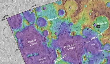
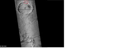
On April 1, 2010, NASA released the first images under the HiWish program in which the public suggested places for HiRISE to photograph. One of the eight locations was Aureum Chaos.<ref name="Ref_d">http://uahirise.org/releases/hiwish-captions.php</ref> The following three images relate to the first images taken under the HiWish program. The first image below gives a wide view of the area from CTX to show where the HiRISE is looking.<ref name="Ref_e">http://hirise.lpl.arizona.edu/ESP_016869_1775</ref> | On April 1, 2010, NASA released the first images under the HiWish program in which the public suggested places for HiRISE to photograph. One of the eight locations was Aureum Chaos.<ref name="Ref_d">http://uahirise.org/releases/hiwish-captions.php</ref> The following three images relate to the first images taken under the HiWish program. The first image below gives a wide view of the area from CTX to show where the HiRISE is looking.<ref name="Ref_e">http://hirise.lpl.arizona.edu/ESP_016869_1775</ref> | ||
| − | <gallery widths=" | + | |
| + | <gallery class="center" widths="380px" heights="360px"> | ||
File:Aureum Chaos wide context.JPG|THEMIS image of wide view of following HiRISE images. Black box shows approximate location of HiRISE images. This image is just a part of the vast area known as Aureum Chaos. Click on image to see more details. | File:Aureum Chaos wide context.JPG|THEMIS image of wide view of following HiRISE images. Black box shows approximate location of HiRISE images. This image is just a part of the vast area known as Aureum Chaos. Click on image to see more details. | ||
| Line 114: | Line 162: | ||
Thousands of pictures have been taken under the HiWish program which has given everyone the privilege of exploring Mars with the best telescope/camera to ever study the Red Planet. The following are other images taken with HiRISE under the HiWish program. | Thousands of pictures have been taken under the HiWish program which has given everyone the privilege of exploring Mars with the best telescope/camera to ever study the Red Planet. The following are other images taken with HiRISE under the HiWish program. | ||
| − | <gallery class="center" widths=" | + | |
| + | <gallery class="center" widths="380px" heights="360px"> | ||
File:55095 2170dunelinecolor.jpg|Dunes | File:55095 2170dunelinecolor.jpg|Dunes | ||
File:29565 2075newcratercomposite.jpg|New, small crater | File:29565 2075newcratercomposite.jpg|New, small crater | ||
| Line 141: | Line 190: | ||
*[https://www.youtube.com/watch?v=YDhHi7upfXM Amazing HiRise Images of Mars] | *[https://www.youtube.com/watch?v=YDhHi7upfXM Amazing HiRise Images of Mars] | ||
*[https://www.youtube.com/watch?v=bdHkgtLgcSY Magnificent Mars: 10 Years of Mars Reconnaissance Orbiter] | *[https://www.youtube.com/watch?v=bdHkgtLgcSY Magnificent Mars: 10 Years of Mars Reconnaissance Orbiter] | ||
| + | * McEwen, A., et al. 2024. The high-resolution imaging science experiment (HiRISE) in the MRO extended science phases (2009–2023). Icarus. Available online 16 September 2023, 115795. In Press. | ||
Latest revision as of 16:26, 13 January 2024
Article written by Jim Secosky. Jim is a retired science teacher who has used the Hubble Space Telescope, the Mars Global Surveyor, and HiRISE.

High Resolution Imaging Science Experiment is a camera on board the Mars Reconnaissance Orbiter. Ball Aerospace & Technologies Corp., under the direction of the University of Arizona's Lunar and Planetary Laboratory built the 0.5 m (19.7 in) diameter reflecting telescope.[1] It is the largest telescope to study Mars from orbit. Most of the time, HiRISE has orbited the planet in a nearly circular orbit to approximately 250 miles (316 Km) above the Martian surface, with a period of about 112 minutes.[2] [3] At this altitude it can take pictures of Mars with resolutions of 0.3 m/pixel (about 1 foot); hence it resolves objects less than a meter across. HiRISE is so powerful that it was able to spot Mars landers on the surface, including the ongoing Curiosity and Opportunity.[4] [5] [6]
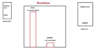
HiRISE images are 5 km wide and can be of various lengths. HiRISE is far more powerful than the camera on Mars Global Surveyor (MGS)

Phoenix lander descending to surface
Tracks of Opportunity Rover at Victoria Crater
Opportunity Rover on its way to Endeavour Crater
Curiosity Rover descending to surface with parachute
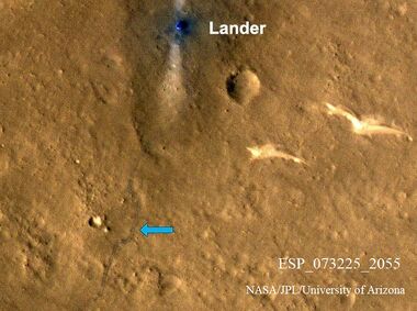
Zhurong, as seen by HiRISE. It's tracks are indicated with blue arrow.China's Zhurong lander is only about the size of a small car, yet HiRISE can see it and its tracks.


Launched on August 12, 2005 by an Atlas V rocket from Cape Canaveral Air Force Station, the Mars Reconnaissance Orbiter (MRO) carrying HiRISE and other instruments arrived at Mars on March 10, 2006. However, it did not begin its main picture taking until November 2006. It began gathering data in November 2006 after completion of a long aerobreaking maneuver in the upper Mars atmosphere to place it in the desired orbit. The orbit has an inclination of 93 degrees, which means it orbits north and south in a polar orbit, as the planet turns beneath it.[7] As a result of the characteristics of its orbit, HiRISE takes pictures at about 3 p.m. local time. This time frame produces few shadows, but does avoid morning mist. To arrange for communications support during the arrival of the InSight Mission, a new Mars lander mission, the orbit was slightly modified on September 28, 2016 by a 75 second engine burn.[8] [9]
Contents
Examples of HiRISE images
The following group of images shows some significant images taken by the instrument. Some of them hint at possible sources of water for future colonists.
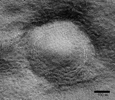
Close view of possible pingo with scale, as seen by HiRISE under HiWish program Pingos may contain a core of pure ice.
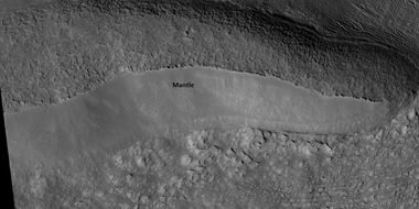
Close view of mantle Mantle may be used as a water source by future colonists.

Color view of dunes defrosting Ice is in the toughs of the polygons.
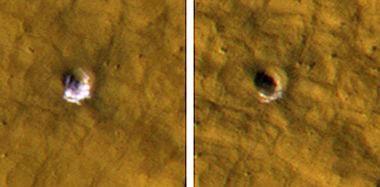
Exposed ice in small craters Ice had almost disappeared when the second picture was taken. This set of images is good evidence that ice lies under a thin layer of debris.
Layers Layers may form with the aid of water.
Evidence of a tsunami caused by an asteroid striking ocean on Mars. These channels were created from the backwash of the giant wave.
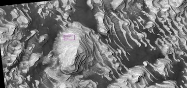
Layers on the floor of Danielson Crater taken under the HiWish program Box shows size of a football field.


Notes about pictures
Most pictures from spacecraft have some sort of enhancement. For many views of Mars there is not much contrast so the contrast is enhanced in a process known as stretching. The darkest parts are set to black while the lightest parts are set to be white. As a result of this process, many features appear much darker. Much of Mars is covered by a brown/red dust that gives little contrast. Pictures would be very bland.
The following back and white image is used to show the difference in colors--depending on how the image is processed.

Wide view of a group of dunes taken just in black and white
The colors for HiRISE images are different than the human eye would see. HiRISE only sees in 3 colors and sometimes infrared is used rather than red. Displaying colors in this way allows us to better identify rocks and minerals. Redder colors usually mean more dust is present, on the other hand bluer colors may show coarser-grained rocks and/or more ferrous minerals such as olivine, pyroxene.[10] Usually, color images are constructed in one of two ways. An IRB image assigns the output from the infrared channel to the color red, the wide red channel to the color green, and the blue-green channel to the color blue. The picture below shows part of the black and white photo processed in IRB.

Dune processed in infrared, red, and green (IRB)
On the other hand, a RGB image has the output of the broad red channel displayed as red, the blue-green channel as green, and a synthetic blue channel (blue-green minus part of the red) as blue. The wavelengths of these channels are: RED: 570-830 nanometers BG: <580 nanometers IR: >790 nanometers. One nanometer is equal to one billionth of a metre (0.000 000 001 m). [11] [12]

Dune processed in the red, green, blue (RGB) channels


HiRISE images are about 5 km wide with a 1 km wide band in the center that is in color.[13] Red color images are at 20,048 pixels wide (6 km in a 300 km orbit), and blue-green and NIR are at 4,048 pixels wide (1.2 km). These are gathered by 14 CCD sensors. HiRISE's onboard computer reads out lines of pixels in time with the orbiter's ground speed; consequently, pictures are potentially unlimited in height. However, height is restricted by the onboard computer's 28 Gigabit (3.5 GByte) memory capacity. The typical maximum size of red images (compressed to 8 bits per pixel) is about 20,000 times 126,000 pixels, or 2520 megapixels and 4,000 times 126,000 pixels (504 megapixels) for the narrower images of the B-G and NIR bands. A single uncompressed image uses up to 28 Gb. However, these images are transmitted compressed, with the usual size being 11.2 Gigabits. These images are released to the general public on the HiRISE website via a new format called JPEG 2000.[14] [15] The full image includes a scale bar of 500 or 1000 meter length.
The following set of pictures show first a full image of a scene and then enlargements from parts of it. A program called HiView can be used to produce more detailed views. Some pictures are in color. HiRISE takes a color strip down the middle only.
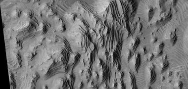
Wide view of layers Parts of this image are enlarged in the following images. The scale bar at the top is 500 meters long.
Enlarged view using HiView of mound Only part of the picture is in color because HiRISE only images an center strip in color.
Close view of layers Picture enlarged using HiView program.


To facilitate the mapping of potential landing sites, HiRISE can produce stereo pairs of images from which the topography can be measured to an accuracy of 0.25 meter.

Wide view of layers in Danielson Crater The center band is in color.
HiRISE compared to other cameras
HiRISE is basically a telescope in a low orbit around Mars; consequently, it can provide unbelievable views of the Martian surface. It is far better than all the other cameras that have gone there to look at the planet. This section displays pictures from a variety of cameras on past spacecraft.
Mariner Crater, as seen by Mariner 4. This may be the best picture that our first spacecraft to fly by Mars took. Image located in Phaethontis quadrangle.
Map showing location of Mariner Crater and other nearby features Black box shows location of enlarged views that were taken with HiRISE.
Wide angle view of part of Mariner Crater with black and red boxes showing locations of close up views Picture taken with CTX. The area in the red box is shown below in a HiRISE image to contain a group of gullies.
Enlargement of troughs from previous image of Mariner Crater. Possible gullies are visible on north wall. This image was taken with CTX camera (on Mars Reconnaissance Orbiter). The location of this image is in the lower black box in the wide view above.
Gullies on the wall of a crater on the floor of Mariner Crater. Some of these gullies were also imaged with HiRISE. Note: this is an enlargement of a previous CTX image.
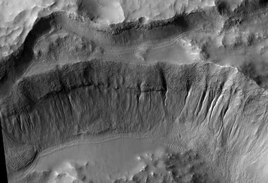
Crater wall inside Mariner Crater, as seen by HiRISE. Note: This is an enlargement of the previous CTX image. This crater sits on the floor of Mariner Crater. This image is from the area in the red box in the wide view shown previously.


The next two images compare pictures taken with 7 different cameras. HiRISE clearly has the best view of the surface.
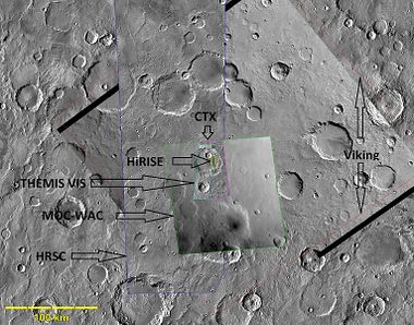
Wide view of portion of Memnonia quadrangle Arrows show locations of images from various cameras. The images from these cameras are shown in the following image. The 7 cameras are HiRISE (Mars Reconnaissance Orbiter), THEMIS VIS (Mars Odyssey), MOC-WAC (Mars Global Surveyor), HRSC (Mars Express), CTX (Mars Reconnaissance Orbiter), Viking, Mariner 4.
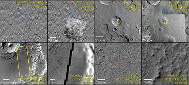
Composite demonstrating relative resolution of 7 different cameras that imaged Mars: HiRISE (Mars Reconnaissance Orbiter), THEMIS VIS (Mars Odyssey), MOC-WAC (Mars Global Surveyor), HRSC (Mars Express), CTX (Mars Reconnaissance Orbiter), Viking, and Mariner 4. Location is Memnonia quadrangle. Blue arrow on some pictures points to same location at with different cameras. Red box with CTX image shows location of the next frame from HiRISE.


Results
As of March 9, 2016, the 10 year Anniversary of MRO, over 2.4 % of the surface has been examined by HiRISE. That is about the area of two Alaska’s. More would have been looked at, but many places were imaged multiple times to look for changes in things like sand dunes, gullies, and streaks. Pictures could contain up to 28 gigabits (Gb) of data. The highly successful mission of Mariner 9 changed many of our ideas about the Red Planet, yet it returned only 7,329 images with a total of 40 Gb of data, according to the final report. [16] [17] So just 2 HiRISE images may contain more than the entire Mariner 9 mission. At the time of this writing (8/14/20, HiRISE had taken 6,882,204 images, generating 194 terabytes of data sent from Mars since 2006.[18] On another note, the first image sent from Mars by Mariner 4 in the summer of 1965 only contained 240,000 bits.[19] One HiRISE image could contain 16,666 times as many bits as that Mariner image. One of the most amazing feats done with HiRISE was capturing dust clouds that were caused by blocks of ice tumbling down cliffs in the North Polar Layered Deposits.[20]
 Wide view of dust clouds being produced when ice chunks fall down cliffs

Dust clouds from ice chunks falling down cliffs
How to view images
Images can be seen at the HiRISE site at http://hirise.lpl.arizona.edu Clicking on the” Catalog” tab at the top will take you to all the HiRISE images. Clicking on the “Caption” tab takes you to hundreds of captioned images that are available in over 20 languages. If you know the image number, you type it in the search box to see it. To see spots in various enlargements, you can download the “HiView “ program that is found on the home page. The “map” tab will allow you to use a map to find HiRISE images of certain areas. For those interested in further understanding Mars, the “Science Nuggets” tab contains posters describing published research using HiRISE. “Updates” shows the latest captioned releases. To see interesting products made with HiRISE images check out the “Special Releases” tab. Several show rovers, such as Opportunity and Curiosity on the surface. One of the most beautiful products created with HiRISE are “Digital Terrain Models.” In a complex, time-consuming process images of the same spot on Mars are taken from slightly different angles. What results is a colorful topographic view. They can be seen with the “DTM” tab. Over 560 have been made so far.
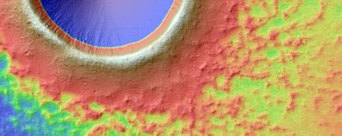
Digital Terrain Model of crater showing topography with different colors

There are several other ways of viewing images. Some allow you to just click on a map location to see what pictures that were taken by HiRISE. One such site is [[1]] http://global-data.mars.asu.edu/bin/hirise.pl Another is at [[2]] https://www.uahirise.org/hiwish/browse
HiWish program
On April 1, 2010, NASA released the first images under the HiWish program in which the public suggested places for HiRISE to photograph. One of the eight locations was Aureum Chaos.[21] The following three images relate to the first images taken under the HiWish program. The first image below gives a wide view of the area from CTX to show where the HiRISE is looking.[22]
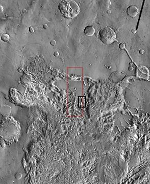
THEMIS image of wide view of following HiRISE images. Black box shows approximate location of HiRISE images. This image is just a part of the vast area known as Aureum Chaos. Click on image to see more details.
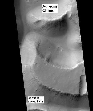
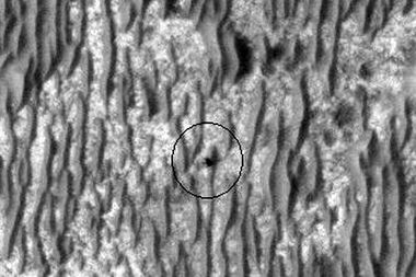
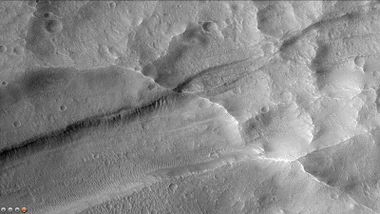
Aureum Chaos, as seen by HiRISE, under the HiWish program. Image is located in Margaritifer Sinus quadrangle.
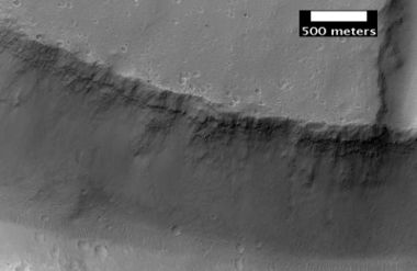
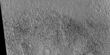
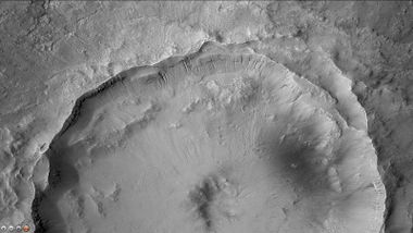
Close up view of previous image, as seen by HiRISE under HiWish program. Small round dots are boulders.


Thousands of pictures have been taken under the HiWish program which has given everyone the privilege of exploring Mars with the best telescope/camera to ever study the Red Planet. The following are other images taken with HiRISE under the HiWish program.
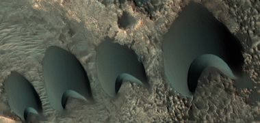
Dunes
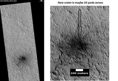
New, small crater
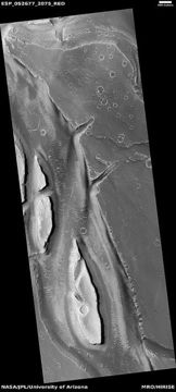
Streamlined shapes created by running water that went from the bottom to the top of the image.
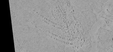
Cones This arrangement of cones was formed by hot lava flowing over icy ground. Ice changed to steam and made these cones. Rafts of lava are also visible to the right


References
- ↑ Mission to Mars: the HiRISE camera on-board MRO, Focal plane arrays for space telescopes III, 27–28 August 2007, San Diego, California, USA
- ↑ https://mars.jpl.nasa.gov/mro/newsroom/pressreleases/20060912a.html
- ↑ https://www.webcitation.org/6EE9oKZFn?url=http://airandspace.si.edu/research/ceps/cepsicons/highlights/fact_sheet_front.pdf
- ↑ VOA News - Mars Orbiter Photographs Old NASA Lander (February 9, 2012)
- ↑ McEwen, A., et al. 2007. Mars Reconnaissance Orbiter's High Resolution Imaging Science Experiment (HiRISE). Journal of Geophysical Research: Planets Volume 112, Issue E5
- ↑ https://agupubs.onlinelibrary.wiley.com/doi/full/10.1029/2005JE002605
- ↑ Lyons, Daniel T. (August 5–8, 2002). "MARS RECONNAISSANCE ORBITER: AEROBRAKING REFERENCE TRAJECTORY" (PDF). AIAA/AAS Astrodynamics Specialist Conference and Exhibit. Archived from the original (PDF) on October 18, 2011. Retrieved March 9, 2012.
- ↑ NASA Mars Orbiter Preparing for Mars Lander's 2016 Arrival
- ↑ Mars orbiter prepares for next year's InSight lander arrival. July 29, 2015.
- ↑ Bergstrom, N.T. Bridges, E.M. Eliason, D. Gallagher, K.E. Herkenhoff, L. Keszthelyi, S. Mattson, G.K. McArthur, M.T. Mellon, M. Milazzo, P.S. Russell, N. Thomas Color imaging of Mars by the high resolution imaging science experiment (HiRISE) Icarus, 205 (2010), pp. 38-52, 10.1016/j.icarus.2009.03.012
- ↑ https://www.uahirise.org/faq/#Colors
- ↑ https://en.wikipedia.org/wiki/Nanometre
- ↑ McEwen, A., et al. 2017. Mars The Prestine Beauty of the Red Planet. University of Arizona Press. Tucson
- ↑ cite web |url=http://marsoweb.nas.nasa.gov/HiRISE/papers/6th_int_mars_conf/Delamere_HiRISE_InstDev.pdf |title=HiRISE: Instrument Development |work=NASA Ames Research Center website |accessdate=7 February 2006 |format=PDF
- ↑ cite web |url=http://www.nasm.si.edu/research/ceps/cepsicons/highlights/fact_sheet_front.pdf |title=Fact Sheet: HiRISE |work=National Air and Space Museum |accessdate=18 February 2006 |format=PDF |deadurl=yes |archiveurl=https://www.webcitation.org/6EE9oKZFn?url=http://airandspace.si.edu/research/ceps/cepsicons/highlights/fact_sheet_front.pdf |archivedate=6 February 2013
- ↑ Techinical Report 32-1550. Volume III. Mariner Mars 1971 Project Final Report.
- ↑ https://ntrs.nasa.gov/archive/nasa/casi.ntrs.nasa.gov/19730018117.pdf
- ↑ https://outlook.live.com/mail/0/inbox/id/AQMkADAwATExAGNiNy00YzQ1LTM4MjMtMDACLTAwCgBGAAADdsmEa%2FgtIEmBK%2FX8yb671wcAkr%2FaXi2mwEKimhNbcs0
- ↑ Leighton, R. 1970. The Surface of Mars. Scientific American: 222, 26-41
- ↑ https://www.uahirise.org/ESP_060176_2640
- ↑ http://uahirise.org/releases/hiwish-captions.php
- ↑ http://hirise.lpl.arizona.edu/ESP_016869_1775
See also
- Martian features that are signs of water ice
- Mars Reconnaissance Orbiter
- Tharsis
- What Mars Actually Looks Like!
External links
- Martian Ice - Jim Secosky - 16th Annual International Mars Society Convention
- Jeffrey Plaut - Subsurface Ice - 21st Annual International Mars Society Convention
- flyover video by Seán Doran of a glacier in Protonilus Mensae, based on NASA ****]
- A FICTIVE FLIGHT ABOVE REAL MARS from Jan Fröjdman
- Vivid Mars - MRO HiRISE
- Amazing HiRise Images of Mars
- Magnificent Mars: 10 Years of Mars Reconnaissance Orbiter
- McEwen, A., et al. 2024. The high-resolution imaging science experiment (HiRISE) in the MRO extended science phases (2009–2023). Icarus. Available online 16 September 2023, 115795. In Press.


