Difference between revisions of "Mars atlas resources"
(Give more information about the gamma ray spectrometer) |
|||
| (18 intermediate revisions by one other user not shown) | |||
| Line 1: | Line 1: | ||
{{Mars atlas}} | {{Mars atlas}} | ||
| − | Some Resources on Mars have been mapped using the gamma ray spectrometer instrument of Mars Odyssey. | + | Some Resources on Mars have been mapped using the gamma ray spectrometer instrument of Mars Odyssey<ref>https://grs.lpl.arizona.edu/latestresults.jsp?lrid=34</ref>. [[Cosmic radiation | Cosmic rays]] activate atoms on the surface, which emit gamma rays at specific frequencies based on the element. This instrument detects surface deposits, and does not show deeper ore bodies. |
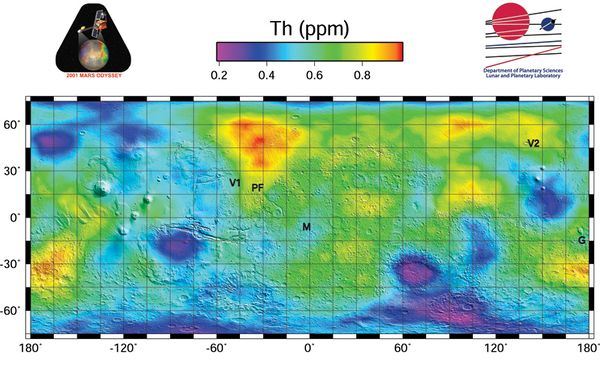
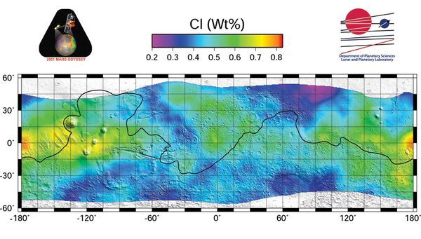
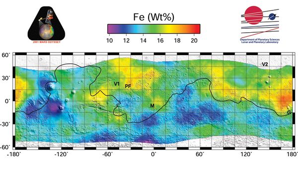
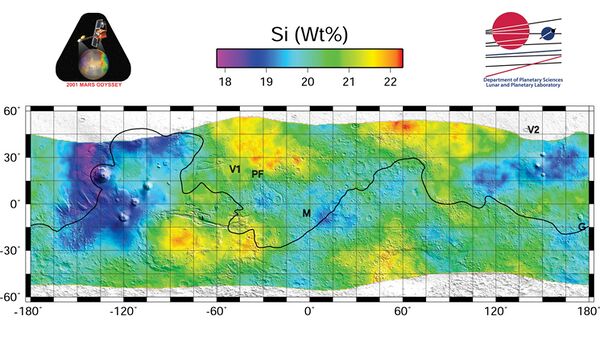
| − | Using the radiation signatures of [[Elements on Mars|elements]] with radioactive isotopes, maps of surface abundance of [[Thorium]], [[Iron]], [[Silicon]], [[Potassium]] have been made. | + | Using the radiation signatures of [[Elements on Mars|elements]] with radioactive isotopes, maps of surface abundance of [[Hydrogen|water (Hydrogen)]], [[Thorium]], [[Chlorine]], [[Iron]], [[Silicon]], [[Potassium]] have been made. |
| + | |||
| + | [[Mars atlas water|Water concentrations]] in polar latitudes are much higher. | ||
| + | [[File:H2O 040305 NG 2x2 Masked SiNorm SmB10 016 EQ6 with2Logos web.jpg|left|thumb|600x600px|Water abundance. %weight. From hydrogen abundance data.]] | ||
[[File:Th 040305 NG 5x5 SmB10 016 EQ75 with2Logos web.jpg|left|thumb|600x600px|Thorium abundance in ppm (parts per million)]] | [[File:Th 040305 NG 5x5 SmB10 016 EQ75 with2Logos web.jpg|left|thumb|600x600px|Thorium abundance in ppm (parts per million)]] | ||
| − | [[File: | + | [[File:Cl abundance.jpg|left|thumb|600x600px|Chlorine abundance. % weight]] |
| − | [[File: | + | [[File:Fe concentration.jpg|left|thumb|600x600px|Iron abundance %weight]] |
| − | + | [[File:Si concentration.jpg|left|thumb|600x600px|Silicon abundance %weight]] | |
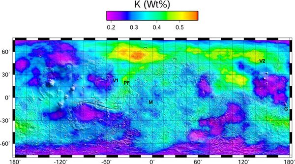
| + | [[File:K Concentration Map web.jpg|left|thumb|600x600px|Potassium abundance %weight]] | ||
| + | |||
| + | ==References== | ||
| + | <references /> | ||
Latest revision as of 08:04, 19 October 2024
Some Resources on Mars have been mapped using the gamma ray spectrometer instrument of Mars Odyssey[1]. Cosmic rays activate atoms on the surface, which emit gamma rays at specific frequencies based on the element. This instrument detects surface deposits, and does not show deeper ore bodies.
Using the radiation signatures of elements with radioactive isotopes, maps of surface abundance of water (Hydrogen), Thorium, Chlorine, Iron, Silicon, Potassium have been made.
Water concentrations in polar latitudes are much higher.

