Difference between revisions of "Mars Odyssey"
(→Results: tried to make map bigger) |
m |
||
| (35 intermediate revisions by 2 users not shown) | |||
| Line 4: | Line 4: | ||
:"''2001 Mars Odyssey is part of NASA's Mars Exploration Program, a long-term effort of robotic exploration of the red planet. The opportunity to go to Mars comes around every 26 months, when the alignment of Earth and Mars in their orbits around the sun allows spacecraft to travel between the two planets with the least amount of energy. 2001 Mars Odyssey launched on April 7, 2001, and arrived at Mars on October 24, 2001, 0230 Universal Time (October 23, 7:30 pm PDT/ 10:30 EDT).''" - [http://mars.jpl.nasa.gov/odyssey/overview/ Mission website]. | :"''2001 Mars Odyssey is part of NASA's Mars Exploration Program, a long-term effort of robotic exploration of the red planet. The opportunity to go to Mars comes around every 26 months, when the alignment of Earth and Mars in their orbits around the sun allows spacecraft to travel between the two planets with the least amount of energy. 2001 Mars Odyssey launched on April 7, 2001, and arrived at Mars on October 24, 2001, 0230 Universal Time (October 23, 7:30 pm PDT/ 10:30 EDT).''" - [http://mars.jpl.nasa.gov/odyssey/overview/ Mission website]. | ||
| + | |||
| + | After spacecraft's main engine fired to place Mars Odyssey into orbit around Mars. It took three months of aerobraking to reduce and circularize the orbit. Odyssey'' was able to save more than 200 kilograms (440 lb) of propellant by allowing atmospheric drag to slow the spacecraft in its final orbit, instead of using fuel. The weight of fuel saved permitted the mission to use a Delta II 7925 launch vehicle, rather than a larger, more expensive rocket.<ref>cite web|url=http://mars.jpl.nasa.gov/odyssey/newsroom/pressreleases/02jan11.html| title=Mars Odyssey: Newsroom| publisher=NASA Jet Propulsion Laboratory</ref> | ||
| + | |||
| + | Odyssey began its science mission on February 19, 2002. It's initial mission lasted until August 2004, but it was granted many mission extensions; consequently, it is still sending back data as of October 2018.<ref>cite web|url=http://mars.nasa.gov/odyssey/mission/timeline/|title=Mission Timeline - Mars Odyssey| publisher=NASA Jet Propulsion Laboratory</ref> On Dec. 15, 2010, Mars Odyssey reached the record for the longest operating spacecraft at Mars, with 3,340 days.<ref>https://solarsystem.nasa.gov/missions/mars-odyssey/in-depth/</ref> | ||
| + | |||
| + | == Scientific instruments == | ||
| + | |||
| + | The three main instruments on Odyssey are: | ||
| + | |||
| + | * Thermal Emission Imaging System (THEMIS)<ref name="themis">cite journal | title=The Thermal Emission Imaging System (THEMIS) for the Mars 2001 Odyssey Mission | first1=P. R. | last1=Christensen | first2=B. M. | last2=Jakosky | first3=H. H. | last3=Kieffer | first4=M. C. | last4=Malin | first5=H. Y. | last5=McSween Jr. | first6=K. | last6=Nealson | first7=G. L. | last7=Mehall | first8=S. H. | last8=Silverman | first9=S. | last9=Ferry | first10=M. | last10=Caplinger | first11=M. | last11=Ravine | journal=Space Science Reviews | volume=110 | issue=1–2 | doi=10.1023/B:SPAC.0000021008.16305.94 | date=2004 | pages=85 |</ref> It images Mars in the visible and infrared parts of the spectrum to determine the thermal characteristics. | ||
| + | |||
| + | The visible imaging camera of THEMIS has a resolution of 18 meters (59 feet); hence, it can resolve objects about the size of a semi-trailer. This resolution lies between large-scale images from the Viking Orbiters (150 to 300 meters per pixel) and the high-resolution images from the Mars Orbiter Camera (MOC) on board Mars Global Surveyor (1.5 to 3 meters per pixel). Visible images from THEMIS are generally close to 20 km wide (12 miles).<ref>http://mars.jpl.nasa.gov/odyssey/technology/themis.html</ref> | ||
| + | |||
| + | * Mars Radiation Environment Experiment (MARIE) This instrument measured radiation both from the sun and from beyond the solar system on the way to Mars and also while in orbit. It used only 7 watts of power.<ref>NASA 2001 Mars Odyssey Launch Press Kit 2001</ref> | ||
| + | |||
| + | * Gamma Ray Spectrometer (GRS)<ref name="mogrsis">cite journal | title=The Mars Odyssey Gamma-Ray Spectrometer Instrument Suite | first1=W.V. | last1=Boynton | first2=W.C. | last2=Feldman | first3=I.G. | last3=Mitrofanov | first4=L.G. | last4=Evans | first5=R.C. | last5=Reedy | first6=S.W. | last6=Squyres | first7=R. | last7=Starr | first8=J.I. | last8=Trombka | first9=C. | last9=d'Uston | first10=J.R. | last10=Arnold | first11=P.A.J. | last11=Englert, | first12=A.E. | last12=Metzger | first13=H. | last13=Wänke | first14=J. | last14=Brückner | first15=D.M. | last15=Drake | first16=C. | last16=Shinohara | first17=C. | last17=Fellows | first18=D.K. | last18=Hamara | first19=K. | last19=Harshman | first20=K. | last20=Kerry | first21=C. | last21=Turner | first22=M. | last22=Ward1 | first23=H. | last23=Barthe | first24=K.R. | last24=Fuller | first25=S.A. | last25=Storms | first26=G.W. | last26=Thornton | first27=J.L. | last27=Longmire | first28=M.L. | last28=Litvak | first29=A.K. | last29=Ton'chev | journal=Space Science Reviews | volume=110 | issue=1–2 | doi=10.1023/B:SPAC.0000021007.76126.15 | year=2004 | pages=37 |</ref> The Gamma Ray Spectrometer was able to map water in the Martian surface--results are shown on maps below. When substances are exposed to the shower of cosmic rays, they emit gamma rays. By studying the rays given off, one can determine the amount of hydrogen and other elements. All the hydrogen is assumed to come from water because water contains lots of hydrogen.<ref>NASA 2001 Mars Odyssey Launch Press Kit 2001</ref> | ||
==Results== | ==Results== | ||
| − | The orbiter recorded and transmitted data about concentration and distribution of [[hydrogen]] and other chemicals of the Martian surface. Additionally, the [[radiation]] conditions were measured, covering ultra violet and gamma. | + | The orbiter recorded and transmitted data about concentration and distribution of [[hydrogen]] and other chemicals of the Martian surface. Additionally, the [[radiation]] conditions were measured, covering ultra violet and gamma. The amount of hydrogen detected is just about equal to the amount of water in the top meter of ground. Water contains 2 parts hydrogen and 1 part oxygen. On Mars, very little, if any, hydrogen comes from chemicals other than water. Detailed analysis of data from the gamma ray spectrometer showed that 20-50 % of the lower level (0.5-1 meter below the surface consists of water ice. Since ice is only half the density of rock, that means that one half of the bottom 50 cm is ice. In other words, one bucket of that material would contain one half bucket of ice.<ref>http://mars.jpl.gov/odyssey/newsroom/pressreleases/20020528a.html</ref> |
[[File:Water equivalent hydrogen abundance in the lower latitudes of Mars 01.jpg|600pxr|Map showing global abundance of water in the surface of Mars, as measured by Mars Odyssey | [[File:Water equivalent hydrogen abundance in the lower latitudes of Mars 01.jpg|600pxr|Map showing global abundance of water in the surface of Mars, as measured by Mars Odyssey | ||
]] | ]] | ||
| − | Map showing global abundance of water in the | + | Map showing global abundance of water in upper meter of Mars, as measured by Mars Odyssey |
| + | |||
| + | [[File:Water equivalent hydrogen abundance in the high latitudes of Mars.jpg|600pxr|Map showing abundance of water in the upper meter of Mars in the high latitudes, as measured by Mars Odyssey]] | ||
| + | |||
| + | Map showing abundance of water in the upper meter of Mars in the high latitudes, as measured by Mars Odyssey | ||
| + | |||
| + | |||
| + | The Mars Odyssey Thermal Emission System (THEMIS) mapped a variety of igneous minerals on the planet. The rocks basalts and dacite were found. Many rocks are olivine-rich. Some of the olivine-rich rocks would be classified as picrites. The presence of dacite implies that some rocks are more evolved. These evolved rocks could contain useful minerals for future colonists.<ref> Christensen, P., et al. 2005. Evidence for magmatic evolution and diversity on Mars from infrared observations. Nature: 436, 504-509.</ref> | ||
| + | ==How to see Mars Odyssey Pictures== | ||
| + | You can find a map of all Mars Odyssey images at [[http://global-data.mars.asu.edu/bin/themis.pl]] http://global-data.mars.asu.edu/bin/themis.pl | ||
| − | + | Just click on the part of the map that you want to see Mars Odyssey pictures of. | |
| − | + | ||
| − | + | One can also go to [[https://themis.asu.edu/gallery]] https://themis.asu.edu/gallery to see pictures arranged in different categories (canyons, layers, etc.), or even live as received by scientists on the ground. | |
==Found substances== | ==Found substances== | ||
| − | + | ||
| + | |||
| + | The presence of chloride salts was a significant find.<ref>[http://www.newscientist.com/article/dn13506-chloride-salts-on-mars-may-have-preserved-past-life.html New Scientist: Chloride salts on Mars may have preserved past life]</ref> <ref>[http://news.bbc.co.uk/1/hi/sci/tech/7302591.stm BBC: Mars is 'covered in table salt']</ref> About 200 locations in the southern hemisphere display spectral characteristics consistent with chloride minerals. These salt deposits occur in the middle to low latitudes all around the planet within southern heavily cratered terrain. The team's report appears in the March 21, 2008 issue of the scientific journal Science.<ref>https://themis.mars.asu.edu/news/salt-deposits-found-martian-highlands</ref> Since many of the deposits sit in low spots with channels leading into them, they may be similar to salt-pan deposits on Earth. Water may have flowed there for a long time. To form salt deposits usually much water has to evaporate to leave salt behind. The places with salts may once held organisms.<ref>https://themis.mars.asu.edu/news/salt-deposits-found-martian-highlands</ref> | ||
==Open issues== | ==Open issues== | ||
| Line 28: | Line 55: | ||
==References== | ==References== | ||
<references/> | <references/> | ||
| + | |||
| + | ==See also== | ||
| + | |||
| + | *[[Aerobraking]] | ||
| + | |||
| + | |||
| + | ==External Links== | ||
| + | |||
| + | *[https://themis.asu.edu/gallery] https://themis.asu.edu/gallery Gallery of Mars Odyssey images | ||
| + | |||
| + | * [[http://global-data.mars.asu.edu/bin/themis.pl]] http://global-data.mars.asu.edu/bin/themis.pl Map of Mars Odyssey images | ||
| + | |||
| − | [[category: | + | [[category:Orbital Missions]] |
Latest revision as of 15:17, 13 October 2021
| This article is a stub. You can help Marspedia by expanding it. |
- "2001 Mars Odyssey is part of NASA's Mars Exploration Program, a long-term effort of robotic exploration of the red planet. The opportunity to go to Mars comes around every 26 months, when the alignment of Earth and Mars in their orbits around the sun allows spacecraft to travel between the two planets with the least amount of energy. 2001 Mars Odyssey launched on April 7, 2001, and arrived at Mars on October 24, 2001, 0230 Universal Time (October 23, 7:30 pm PDT/ 10:30 EDT)." - Mission website.
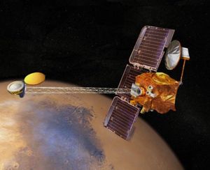
After spacecraft's main engine fired to place Mars Odyssey into orbit around Mars. It took three months of aerobraking to reduce and circularize the orbit. Odyssey was able to save more than 200 kilograms (440 lb) of propellant by allowing atmospheric drag to slow the spacecraft in its final orbit, instead of using fuel. The weight of fuel saved permitted the mission to use a Delta II 7925 launch vehicle, rather than a larger, more expensive rocket.[1]
Odyssey began its science mission on February 19, 2002. It's initial mission lasted until August 2004, but it was granted many mission extensions; consequently, it is still sending back data as of October 2018.[2] On Dec. 15, 2010, Mars Odyssey reached the record for the longest operating spacecraft at Mars, with 3,340 days.[3]
Contents
Scientific instruments
The three main instruments on Odyssey are:
- Thermal Emission Imaging System (THEMIS)[4] It images Mars in the visible and infrared parts of the spectrum to determine the thermal characteristics.
The visible imaging camera of THEMIS has a resolution of 18 meters (59 feet); hence, it can resolve objects about the size of a semi-trailer. This resolution lies between large-scale images from the Viking Orbiters (150 to 300 meters per pixel) and the high-resolution images from the Mars Orbiter Camera (MOC) on board Mars Global Surveyor (1.5 to 3 meters per pixel). Visible images from THEMIS are generally close to 20 km wide (12 miles).[5]
- Mars Radiation Environment Experiment (MARIE) This instrument measured radiation both from the sun and from beyond the solar system on the way to Mars and also while in orbit. It used only 7 watts of power.[6]
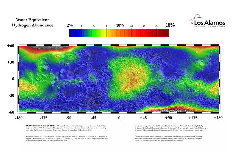
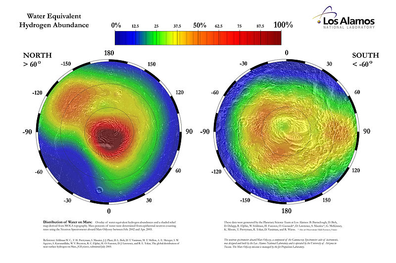
- Gamma Ray Spectrometer (GRS)[7] The Gamma Ray Spectrometer was able to map water in the Martian surface--results are shown on maps below. When substances are exposed to the shower of cosmic rays, they emit gamma rays. By studying the rays given off, one can determine the amount of hydrogen and other elements. All the hydrogen is assumed to come from water because water contains lots of hydrogen.[8]
Results
The orbiter recorded and transmitted data about concentration and distribution of hydrogen and other chemicals of the Martian surface. Additionally, the radiation conditions were measured, covering ultra violet and gamma. The amount of hydrogen detected is just about equal to the amount of water in the top meter of ground. Water contains 2 parts hydrogen and 1 part oxygen. On Mars, very little, if any, hydrogen comes from chemicals other than water. Detailed analysis of data from the gamma ray spectrometer showed that 20-50 % of the lower level (0.5-1 meter below the surface consists of water ice. Since ice is only half the density of rock, that means that one half of the bottom 50 cm is ice. In other words, one bucket of that material would contain one half bucket of ice.[9]
Map showing global abundance of water in upper meter of Mars, as measured by Mars Odyssey
Map showing abundance of water in the upper meter of Mars in the high latitudes, as measured by Mars Odyssey
The Mars Odyssey Thermal Emission System (THEMIS) mapped a variety of igneous minerals on the planet. The rocks basalts and dacite were found. Many rocks are olivine-rich. Some of the olivine-rich rocks would be classified as picrites. The presence of dacite implies that some rocks are more evolved. These evolved rocks could contain useful minerals for future colonists.[10]
How to see Mars Odyssey Pictures
You can find a map of all Mars Odyssey images at [[1]] http://global-data.mars.asu.edu/bin/themis.pl
Just click on the part of the map that you want to see Mars Odyssey pictures of.
One can also go to [[2]] https://themis.asu.edu/gallery to see pictures arranged in different categories (canyons, layers, etc.), or even live as received by scientists on the ground.
Found substances
The presence of chloride salts was a significant find.[11] [12] About 200 locations in the southern hemisphere display spectral characteristics consistent with chloride minerals. These salt deposits occur in the middle to low latitudes all around the planet within southern heavily cratered terrain. The team's report appears in the March 21, 2008 issue of the scientific journal Science.[13] Since many of the deposits sit in low spots with channels leading into them, they may be similar to salt-pan deposits on Earth. Water may have flowed there for a long time. To form salt deposits usually much water has to evaporate to leave salt behind. The places with salts may once held organisms.[14]
Open issues
What are the exact data?
References
- ↑ cite web|url=http://mars.jpl.nasa.gov/odyssey/newsroom/pressreleases/02jan11.html%7C title=Mars Odyssey: Newsroom| publisher=NASA Jet Propulsion Laboratory
- ↑ cite web|url=http://mars.nasa.gov/odyssey/mission/timeline/%7Ctitle=Mission Timeline - Mars Odyssey| publisher=NASA Jet Propulsion Laboratory
- ↑ https://solarsystem.nasa.gov/missions/mars-odyssey/in-depth/
- ↑ cite journal | title=The Thermal Emission Imaging System (THEMIS) for the Mars 2001 Odyssey Mission | first1=P. R. | last1=Christensen | first2=B. M. | last2=Jakosky | first3=H. H. | last3=Kieffer | first4=M. C. | last4=Malin | first5=H. Y. | last5=McSween Jr. | first6=K. | last6=Nealson | first7=G. L. | last7=Mehall | first8=S. H. | last8=Silverman | first9=S. | last9=Ferry | first10=M. | last10=Caplinger | first11=M. | last11=Ravine | journal=Space Science Reviews | volume=110 | issue=1–2 | doi=10.1023/B:SPAC.0000021008.16305.94 | date=2004 | pages=85 |
- ↑ http://mars.jpl.nasa.gov/odyssey/technology/themis.html
- ↑ NASA 2001 Mars Odyssey Launch Press Kit 2001
- ↑ cite journal | title=The Mars Odyssey Gamma-Ray Spectrometer Instrument Suite | first1=W.V. | last1=Boynton | first2=W.C. | last2=Feldman | first3=I.G. | last3=Mitrofanov | first4=L.G. | last4=Evans | first5=R.C. | last5=Reedy | first6=S.W. | last6=Squyres | first7=R. | last7=Starr | first8=J.I. | last8=Trombka | first9=C. | last9=d'Uston | first10=J.R. | last10=Arnold | first11=P.A.J. | last11=Englert, | first12=A.E. | last12=Metzger | first13=H. | last13=Wänke | first14=J. | last14=Brückner | first15=D.M. | last15=Drake | first16=C. | last16=Shinohara | first17=C. | last17=Fellows | first18=D.K. | last18=Hamara | first19=K. | last19=Harshman | first20=K. | last20=Kerry | first21=C. | last21=Turner | first22=M. | last22=Ward1 | first23=H. | last23=Barthe | first24=K.R. | last24=Fuller | first25=S.A. | last25=Storms | first26=G.W. | last26=Thornton | first27=J.L. | last27=Longmire | first28=M.L. | last28=Litvak | first29=A.K. | last29=Ton'chev | journal=Space Science Reviews | volume=110 | issue=1–2 | doi=10.1023/B:SPAC.0000021007.76126.15 | year=2004 | pages=37 |
- ↑ NASA 2001 Mars Odyssey Launch Press Kit 2001
- ↑ http://mars.jpl.gov/odyssey/newsroom/pressreleases/20020528a.html
- ↑ Christensen, P., et al. 2005. Evidence for magmatic evolution and diversity on Mars from infrared observations. Nature: 436, 504-509.
- ↑ New Scientist: Chloride salts on Mars may have preserved past life
- ↑ BBC: Mars is 'covered in table salt'
- ↑ https://themis.mars.asu.edu/news/salt-deposits-found-martian-highlands
- ↑ https://themis.mars.asu.edu/news/salt-deposits-found-martian-highlands
See also
External Links
- [3] https://themis.asu.edu/gallery Gallery of Mars Odyssey images
- [[4]] http://global-data.mars.asu.edu/bin/themis.pl Map of Mars Odyssey images


