File:58137 2090streamlined.jpg

Size of this preview: 320 × 600 pixels. Other resolution: 512 × 960 pixels.
Original file (512 × 960 pixels, file size: 78 KB, MIME type: image/jpeg)
Summary
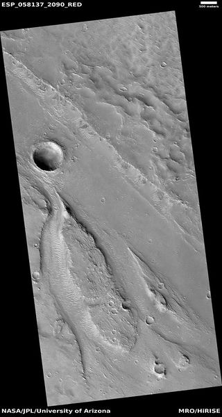
Streamlined features These were created by the erosion of running water that flowed from the bottom of the image to the top. This direction can be determined by the way the erosion tails are pointed.
The location is the Amenthes quadrangle at 28.599 N and 129.21 E Source: http://hirise.lpl.arizona.edu/ESP_058137_2090 (ESP_058137_2090). NASA/JPL/University of Arizona
File history
Click on a date/time to view the file as it appeared at that time.
| Date/Time | Thumbnail | Dimensions | User | Comment | |
|---|---|---|---|---|---|
| current | 12:34, 23 February 2020 | | 512 × 960 (78 KB) | Suitupandshowup (talk | contribs) | Streamlined features These were created by the erosion of running water that flowed from the bottom of the image to the top. This direction can be determined by the way the erosion tails are pointed. The location is the Amenthes quadrangle at 28.599 N and 129.21 E Source: http://hirise.lpl.arizona.edu/ESP_058137_2090 (ESP_058137_2090). NASA/JPL/University of Arizona |
You cannot overwrite this file.
File usage
The following page uses this file:


