Difference between revisions of "Terra Sirenum"
m (typo) |
|||
| (16 intermediate revisions by 3 users not shown) | |||
| Line 1: | Line 1: | ||
| − | '''Terra Sirenum''' (latin for "''Sea of the Sirens''") is a region located in the southern hemisphere of [[Mars]] (at 39.7 °S, 150 °W). Terra Sirenum covers a large landmass and at its longest extent | + | {{Mars atlas}} |
| + | [[File:Wikimolaargyre.jpg|thumb|300px|right|MOLA map showing boundaries of Terra Sirenum and other regions]] | ||
| + | [[File:Wikimolasouthpole.jpg|thumb|300px|right|MOLA map showing boundaries of Terra Sirenum near the south pole and other regions]] | ||
| + | |||
| + | '''Terra Sirenum''' (latin for "''Sea of the Sirens''") is a region located in the southern hemisphere of [[Mars]] (at 39.7 °S, 150 °W). Terra Sirenum covers a large landmass and at its longest extent spans 3900 km (2420 mi), approximating the distance from New York to Los Angeles. | ||
| + | The region of Terra Sirenum contains many interesting features, including ones that probably contain water ice. Robotic machines may travel to Terra Sirenum to obtain water for future Martian colonies. | ||
| + | Terra Sirenum is in the Phaethontis and the Memnonia quadrangles of Mars. A low area in Terra Sirenum is believed to have once held a lake that eventually drained through Ma'adim Vallis.<ref>Irwin,R, et al. 2002. Geomorphology of Ma'adim Vallis, Mars and associated paleolake basins. J. Geophys. Res. 109(E12)</ref> <ref name="Carr2006">cite book|author=Michael H. Carr|title=The surface of Mars|url=https://books.google.com/books?id=uLHlJ6sjohwC|accessdate=21 March 2011|year=2006|publisher=Cambridge University Press|isbn=978-0-521-87201-0</ref> <ref>https://www.uahirise.org/ESP_050948_1430</ref> | ||
==Observation== | ==Observation== | ||
| Line 5: | Line 11: | ||
[[Image:Water_deposit.jpg|thumb|right|200px|Evidence from the [[Mars Global Surveyor]] MOC instrument that spurts of liquid water may sporadically flow on the '''Terra Sirenum''' region.]] | [[Image:Water_deposit.jpg|thumb|right|200px|Evidence from the [[Mars Global Surveyor]] MOC instrument that spurts of liquid water may sporadically flow on the '''Terra Sirenum''' region.]] | ||
| − | ==External links== | + | ==Concentric crater fill== |
| + | Concentric crater fill contains large amounts of ice under a cover of insulating debris.<ref>Levy, J. et al. 2009. Concentric crater fill in Utopia Planitia: History and interaction between glacial "brain terrain" and periglacial processes. Icarus: 202. 462-476.</ref> Based on accurate topography measures of height and calculations of how deep the craters should be based on their diameters, it is thought that the craters are 80% filled with mostly ice.<ref>Levy, J., J. Head, D. Marchant. 2010. Concentric Crater fill in the northern mid-latitudes of Mars: Formation process and relationships to similar landforms of glacial origin. Icarus 2009, 390-404.</ref > <ref>Levy, J., J. Head, J. Dickson, C. Fassett, G. Morgan, S. Schon. 2010. Identification of gully debris flow deposits in Protonilus Mensae, Mars: Characterization of a water-bearing, energetic gully-forming process. Earth Planet. Sci. Lett. 294, 368–377.</ref> <ref>http://hirise.lpl.arizona.edu/ESP_032569_2225</ref> <ref>Garvin, J., S. Sakimoto, J. Frawley. 2003. Craters on Mars: Geometric properties from gridded MOLA topography. In: Sixth International Conference on Mars. July 20–25, 2003, Pasadena, California. Abstract 3277.</ref> The ice accumulated in the crater from snowfall in previous climates.<ref>Kreslavsky, M. and J. Head. 2006. Modification of impact craters in the northern plains of Mars: Implications for the Amazonian climate history. Meteorit. Planet. Sci.: 41. 1633-1646</ref> <ref>Madeleine, J. et al. 2007. Exploring the northern mid-latitude glaciation with a general circulation model. In: Seventh International Conference on Mars. Abstract 3096.</ref> <ref>http://hirise.lpl.arizona.edu/PSP_002917_2175</ref> Recent modeling suggests that concentric crater fill develops over many cycles in which snow is deposited, then moves into the crater. Once inside the crater shade and dust preserve the snow, the snow changes to ice. The many concentric lines are created by the many cycles of snow accumulation. <ref>Fastook, J., J.Head. 2014. Concentric crater fill: Rates of glacial accumulation, infilling and deglaciation in the Amazonian and Noachian of Mars. 45th Lunar and Planetary Science Conference (2014) 1227.pdf</ref> | ||
| + | |||
| + | <gallery class="center" widths="190px" heights="180px" > | ||
| + | Wikiconcentric.jpg|Crater showing concentric crater fill, as seen by CTX (on Mars Reconnaissance Orbiter) | ||
| + | Wikiconcentricclose22451.jpg|Close-up view of concentric crater fill, as seen by HiRISE Note: this is an enlargement of previous image of a concentric crater. | ||
| + | </gallery> | ||
| + | |||
| + | ==Latitude Dependent Mantle== | ||
| + | Parts of Mars are covered by a smooth coating that in some cases is layered and quite thick. <ref>Mustard, J., C. Cooper, M. Rifkin. 2001. Evidence for recent climate change on Mars from the identification of youthful near-surface ground ice. Nature 412, 411–414 .</ref > It’s generally accepted that mantle is ice-rich dust that fell from the sky as snow and ice-coated dust grains during a different climate. > Some parts are eroded, revealing rough surfaces. <ref> Pollack, J., D. Colburn, F. Flaser, R. Kahn, C. Carson, and D. Pidek. 1979. Properties and effects of dust suspended in the martian atmosphere. J. Geophys. Res. 84, 2929-2945. </ref> | ||
| + | [[File: Esp 037167 1445mantle.jpg| |thumb|300px|left| Surface showing appearance with and without mantle covering Mantle contains ice.]] | ||
| + | |||
| + | ==Glacial Features== | ||
| + | Several features have been observed that have the shape of glaciers. Even though ice is not stable at many latitudes of Mars, ice could survive for long periods under a few meters of dirt and rock. <ref> Head, J. W.; et al. (2006). "Extensive valley glacier deposits in the northern mid-latitudes of Mars: Evidence for Late Amazonian obliquity-driven climate change". Earth and Planetary Science Letters. 241 (3): 663–671.</ref> | ||
| + | Some look like alpine or mountain glaciers of the Earth. <ref> Arfstrom, J and W. Hartmann. 2005. Martian flow features, moraine-like ridges, and gullies: Terrestrial analogs and interrelationships. Icarus 174, 321-335.</ref> <ref> Hubbard B., R. Milliken, J. Kargel , A. Limaye, C. Souness . 2011. Geomorphological characterization and interpretation of a mid-latitude glacier-like form: Hellas Planitia, Mars Icarus 211, 330–346 </ref> <ref> Hubbard B., R. Milliken, J. Kargel , A. Limaye, C. Souness . 2011. Geomorphological characterization and interpretation of a mid-latitude glacier-like form: Hellas Planitia, Mars Icarus 211, 330–346 </ref> | ||
| + | |||
| + | <gallery class="center" widths="190px" heights="180px" > | ||
| + | File:ESP 036995 1410tonguewide.jpg|Tongue-shaped glacier, as seen by HiRISE under HiWish program | ||
| + | </gallery> | ||
| + | |||
| + | ==Oxbow lake== | ||
| + | An oxblow lake forms when a channel forms a short cut across a meander. The presence of an oxbow lake means that water flowed long enough to erode a meander before a cutoff was formed. | ||
| + | |||
| + | [[File: WikiESP 039594 1365oxbow.jpg |thumb|300px|left|Oxbow lake, as seen by HiRISE under HiWish program.]] | ||
| + | |||
| + | |||
| + | ==Pingos== | ||
| + | Because of the many signs of ground ice, scientists have speculated for years that pingos may be found on the planet. Pingos form in ice-rich ground and contain a core of pure ice. However, we may not be sure if they are real pingos until they are examined by rovers. One picture below from HiRISE may be a pingo. | ||
| + | The radial and concentric cracks visible here are common when forces penetrate a brittle layer, such as a rock thrown through a glass window. These fractures were probably created by something emerging from below the brittle surface. Ice may have built up under the surface in a lens shape; consequently making these cracked mounds. Since ice is less dense than rock, it probably pushed upwards on the surface and made these spider web-like patterns. A similar process creates similar sized mounds in arctic tundra on Earth. <ref>http://www.uahirise.org/ESP_046359_1250</ref> | ||
| + | |||
| + | [[File: ESP 046359 1250-2pingoscale.jpg|thumb|300px|right| Close view of possible pingo with scale, as seen by HiRISE under HiWish program]] | ||
| + | |||
| + | ==Gullies== | ||
| + | |||
| + | '''Terra Sirenum''' is the location of many Martian gullies that may be due to recent flowing water. Some are found in the Gorgonum Chaos<ref>http://hirise.lpl.arizona.edu/PSP_004071_1425</ref> <ref>http://hirise.lpl.arizona.edu/PSP_001948_1425</ref> and in many craters near the large craters Copernicus and Newton Crater.<ref>http://hirise.lpl.arizona.edu/PSP_004163_1375</ref> <ref>U.S. department of the Interior U.S. Geological Survey, Topographic Map of the Eastern Region of Mars M 15M 0/270 2AT, 1991</ref> Gullies occur on steep slopes, especially on the walls of craters. Gullies are believed to be relatively young because they have few, if any craters. Usually, each gully has an alcove, channel, and apron. Many theories have been proposed for the origin of gullies on Mars. Many involve flowing water. However, with more repeated observations it was found that gullies could form today when pieces of dry ice go down steep slopes. Furthermore, experiments on the Earth can duplicate gullies with pieces of dry ice moving down slopes. <ref>Harrington, J.D.; Webster, Guy (July 10, 2014). "RELEASE 14-191 – NASA Spacecraft Observes Further Evidence of Dry Ice Gullies on Mars".</ref> In the distant past some water may have been involved with some gullies.<ref> Jawin, E, J. Head, D. Marchant. 2018. Transient post-glacial processes on Mars: Geomorphologic evidence for a paraglacial period. Icarus: 309, 187-206</ref> | ||
| + | |||
| + | [[File:ESP 039753 1385gulliespits.jpg|thumb|300px|left|Large group of gullies]] | ||
| + | |||
| + | ==References== | ||
| + | {{reflist|colwidth=30em}} | ||
| + | |||
| + | == External links == | ||
| + | * [https://www.youtube.com/watch?v=_sUUKcZaTgA Martian Ice - Jim Secosky - 16th Annual International Mars Society Convention] | ||
| + | * https://www.youtube.com/watch?v=kpnTh3qlObk[T. Gordon Wasilewski - Water on Mars - 20th Annual International Mars Society Convention] Describes how to get water from ice in the ground | ||
| + | |||
*[http://www.google.com/mars/#lat=-2.635788&lon=-113.203125&map=visible&q=Terra%20Sirenum Location of Terra Sirenum (Google Mars)]. | *[http://www.google.com/mars/#lat=-2.635788&lon=-113.203125&map=visible&q=Terra%20Sirenum Location of Terra Sirenum (Google Mars)]. | ||
*[http://www.nasa.gov/mission_pages/mars/images/pia09027.html Images of suspected gullies in Terra Sirenum]. | *[http://www.nasa.gov/mission_pages/mars/images/pia09027.html Images of suspected gullies in Terra Sirenum]. | ||
| − | [[ | + | |
| + | [[Category:Areography]] | ||
Latest revision as of 16:48, 9 November 2020
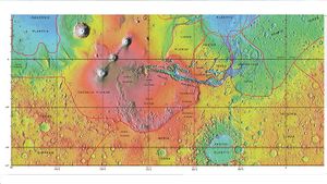
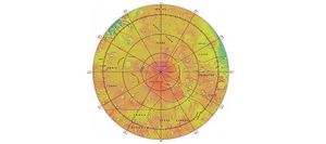
Terra Sirenum (latin for "Sea of the Sirens") is a region located in the southern hemisphere of Mars (at 39.7 °S, 150 °W). Terra Sirenum covers a large landmass and at its longest extent spans 3900 km (2420 mi), approximating the distance from New York to Los Angeles. The region of Terra Sirenum contains many interesting features, including ones that probably contain water ice. Robotic machines may travel to Terra Sirenum to obtain water for future Martian colonies. Terra Sirenum is in the Phaethontis and the Memnonia quadrangles of Mars. A low area in Terra Sirenum is believed to have once held a lake that eventually drained through Ma'adim Vallis.[1] [2] [3]
Contents
Observation
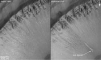
- Surveys by the Mars Global Surveyor, MOC instrument revealed evidence of liquid water "spurts" in this location in 2005.
Concentric crater fill
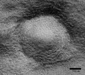
Concentric crater fill contains large amounts of ice under a cover of insulating debris.[4] Based on accurate topography measures of height and calculations of how deep the craters should be based on their diameters, it is thought that the craters are 80% filled with mostly ice.[5] [6] [7] [8] The ice accumulated in the crater from snowfall in previous climates.[9] [10] [11] Recent modeling suggests that concentric crater fill develops over many cycles in which snow is deposited, then moves into the crater. Once inside the crater shade and dust preserve the snow, the snow changes to ice. The many concentric lines are created by the many cycles of snow accumulation. [12]
Latitude Dependent Mantle
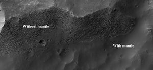
Parts of Mars are covered by a smooth coating that in some cases is layered and quite thick. [13] It’s generally accepted that mantle is ice-rich dust that fell from the sky as snow and ice-coated dust grains during a different climate. > Some parts are eroded, revealing rough surfaces. [14]
Glacial Features
Several features have been observed that have the shape of glaciers. Even though ice is not stable at many latitudes of Mars, ice could survive for long periods under a few meters of dirt and rock. [15] Some look like alpine or mountain glaciers of the Earth. [16] [17] [18]
Oxbow lake
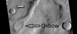
An oxblow lake forms when a channel forms a short cut across a meander. The presence of an oxbow lake means that water flowed long enough to erode a meander before a cutoff was formed.
Pingos
Because of the many signs of ground ice, scientists have speculated for years that pingos may be found on the planet. Pingos form in ice-rich ground and contain a core of pure ice. However, we may not be sure if they are real pingos until they are examined by rovers. One picture below from HiRISE may be a pingo. The radial and concentric cracks visible here are common when forces penetrate a brittle layer, such as a rock thrown through a glass window. These fractures were probably created by something emerging from below the brittle surface. Ice may have built up under the surface in a lens shape; consequently making these cracked mounds. Since ice is less dense than rock, it probably pushed upwards on the surface and made these spider web-like patterns. A similar process creates similar sized mounds in arctic tundra on Earth. [19]
Gullies
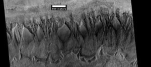
Terra Sirenum is the location of many Martian gullies that may be due to recent flowing water. Some are found in the Gorgonum Chaos[20] [21] and in many craters near the large craters Copernicus and Newton Crater.[22] [23] Gullies occur on steep slopes, especially on the walls of craters. Gullies are believed to be relatively young because they have few, if any craters. Usually, each gully has an alcove, channel, and apron. Many theories have been proposed for the origin of gullies on Mars. Many involve flowing water. However, with more repeated observations it was found that gullies could form today when pieces of dry ice go down steep slopes. Furthermore, experiments on the Earth can duplicate gullies with pieces of dry ice moving down slopes. [24] In the distant past some water may have been involved with some gullies.[25]
References
- ↑ Irwin,R, et al. 2002. Geomorphology of Ma'adim Vallis, Mars and associated paleolake basins. J. Geophys. Res. 109(E12)
- ↑ cite book|author=Michael H. Carr|title=The surface of Mars|url=https://books.google.com/books?id=uLHlJ6sjohwC%7Caccessdate=21 March 2011|year=2006|publisher=Cambridge University Press|isbn=978-0-521-87201-0
- ↑ https://www.uahirise.org/ESP_050948_1430
- ↑ Levy, J. et al. 2009. Concentric crater fill in Utopia Planitia: History and interaction between glacial "brain terrain" and periglacial processes. Icarus: 202. 462-476.
- ↑ Levy, J., J. Head, D. Marchant. 2010. Concentric Crater fill in the northern mid-latitudes of Mars: Formation process and relationships to similar landforms of glacial origin. Icarus 2009, 390-404.
- ↑ Levy, J., J. Head, J. Dickson, C. Fassett, G. Morgan, S. Schon. 2010. Identification of gully debris flow deposits in Protonilus Mensae, Mars: Characterization of a water-bearing, energetic gully-forming process. Earth Planet. Sci. Lett. 294, 368–377.
- ↑ http://hirise.lpl.arizona.edu/ESP_032569_2225
- ↑ Garvin, J., S. Sakimoto, J. Frawley. 2003. Craters on Mars: Geometric properties from gridded MOLA topography. In: Sixth International Conference on Mars. July 20–25, 2003, Pasadena, California. Abstract 3277.
- ↑ Kreslavsky, M. and J. Head. 2006. Modification of impact craters in the northern plains of Mars: Implications for the Amazonian climate history. Meteorit. Planet. Sci.: 41. 1633-1646
- ↑ Madeleine, J. et al. 2007. Exploring the northern mid-latitude glaciation with a general circulation model. In: Seventh International Conference on Mars. Abstract 3096.
- ↑ http://hirise.lpl.arizona.edu/PSP_002917_2175
- ↑ Fastook, J., J.Head. 2014. Concentric crater fill: Rates of glacial accumulation, infilling and deglaciation in the Amazonian and Noachian of Mars. 45th Lunar and Planetary Science Conference (2014) 1227.pdf
- ↑ Mustard, J., C. Cooper, M. Rifkin. 2001. Evidence for recent climate change on Mars from the identification of youthful near-surface ground ice. Nature 412, 411–414 .
- ↑ Pollack, J., D. Colburn, F. Flaser, R. Kahn, C. Carson, and D. Pidek. 1979. Properties and effects of dust suspended in the martian atmosphere. J. Geophys. Res. 84, 2929-2945.
- ↑ Head, J. W.; et al. (2006). "Extensive valley glacier deposits in the northern mid-latitudes of Mars: Evidence for Late Amazonian obliquity-driven climate change". Earth and Planetary Science Letters. 241 (3): 663–671.
- ↑ Arfstrom, J and W. Hartmann. 2005. Martian flow features, moraine-like ridges, and gullies: Terrestrial analogs and interrelationships. Icarus 174, 321-335.
- ↑ Hubbard B., R. Milliken, J. Kargel , A. Limaye, C. Souness . 2011. Geomorphological characterization and interpretation of a mid-latitude glacier-like form: Hellas Planitia, Mars Icarus 211, 330–346
- ↑ Hubbard B., R. Milliken, J. Kargel , A. Limaye, C. Souness . 2011. Geomorphological characterization and interpretation of a mid-latitude glacier-like form: Hellas Planitia, Mars Icarus 211, 330–346
- ↑ http://www.uahirise.org/ESP_046359_1250
- ↑ http://hirise.lpl.arizona.edu/PSP_004071_1425
- ↑ http://hirise.lpl.arizona.edu/PSP_001948_1425
- ↑ http://hirise.lpl.arizona.edu/PSP_004163_1375
- ↑ U.S. department of the Interior U.S. Geological Survey, Topographic Map of the Eastern Region of Mars M 15M 0/270 2AT, 1991
- ↑ Harrington, J.D.; Webster, Guy (July 10, 2014). "RELEASE 14-191 – NASA Spacecraft Observes Further Evidence of Dry Ice Gullies on Mars".
- ↑ Jawin, E, J. Head, D. Marchant. 2018. Transient post-glacial processes on Mars: Geomorphologic evidence for a paraglacial period. Icarus: 309, 187-206
External links
- Martian Ice - Jim Secosky - 16th Annual International Mars Society Convention
- https://www.youtube.com/watch?v=kpnTh3qlObk[T. Gordon Wasilewski - Water on Mars - 20th Annual International Mars Society Convention] Describes how to get water from ice in the ground
