Difference between revisions of "Potassium"
| Line 7: | Line 7: | ||
}} | }} | ||
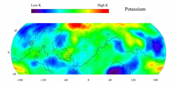
[[File:PIA04255 hires.jpg|thumb|600x600px|Mars Odyssey - Potassium abundance on Mars<ref>https://www.jpl.nasa.gov/spaceimages/details.php?id=PIA04255#:~:text=Potassium%2C%20having%20the%20chemical%20symbol,N%2C%20%2D30%20degrees).</ref>]] | [[File:PIA04255 hires.jpg|thumb|600x600px|Mars Odyssey - Potassium abundance on Mars<ref>https://www.jpl.nasa.gov/spaceimages/details.php?id=PIA04255#:~:text=Potassium%2C%20having%20the%20chemical%20symbol,N%2C%20%2D30%20degrees).</ref>]] | ||
| − | Potassium, ''[[Elements on Mars|periodic table]] K'', is a solid at room temperature. It's most common isotope is <sup>39</sup>K. | + | Potassium, ''[[Elements on Mars|periodic table]] K'', is a solid at room temperature. It's most common isotope is <sup>39</sup>K. <sup>40</sup>K is a radioactive isotope with a half life of 1.248×10<sup>9</sup> years. It's abundance can be measured remotely. Potassium is fairly abundant on the Martian surface, with a higher abundance than in Earth's crust, where it makes up about 2.6% of the weight of the crust and is the seventh most abundant element. |
| − | Potassium is | + | Potassium is a [[Fertilizer|fertilizer.]] |
{{stub}} | {{stub}} | ||
==Mars Odyssey Potassium abundance map== | ==Mars Odyssey Potassium abundance map== | ||
| − | This gamma ray spectrometer map of the mid-latitude region of Mars is based on gamma-rays from the | + | This gamma ray spectrometer map of the mid-latitude region of Mars is based on gamma-rays from the <sup>40</sup>K isotope of Potassium that was measured by Mars Odyssey. |
The region of highest potassium content, shown in red, is concentrated in the northern part of Acidalia Planitia (centered near 55 degrees N, -30 degrees). Several areas of low potassium content, shown in blue, are distributed across the mid-latitudes, with two significant low concentrations, one associated with the Hellas Basin (centered near 35 degrees S, 70 degrees) and the other lying southeast of Elysium Mons (centered near 10 degrees N, 160 degrees). Contours of constant surface elevation are also shown. The long continuous line running from east to west marks the approximate separation of the younger lowlands in the north from the older highlands in the south. | The region of highest potassium content, shown in red, is concentrated in the northern part of Acidalia Planitia (centered near 55 degrees N, -30 degrees). Several areas of low potassium content, shown in blue, are distributed across the mid-latitudes, with two significant low concentrations, one associated with the Hellas Basin (centered near 35 degrees S, 70 degrees) and the other lying southeast of Elysium Mons (centered near 10 degrees N, 160 degrees). Contours of constant surface elevation are also shown. The long continuous line running from east to west marks the approximate separation of the younger lowlands in the north from the older highlands in the south. | ||
Revision as of 18:49, 24 November 2020
| K | 19 |
| Potassium | |
Abundance: 0.0%

Potassium, periodic table K, is a solid at room temperature. It's most common isotope is 39K. 40K is a radioactive isotope with a half life of 1.248×10⁹ years. It's abundance can be measured remotely. Potassium is fairly abundant on the Martian surface, with a higher abundance than in Earth's crust, where it makes up about 2.6% of the weight of the crust and is the seventh most abundant element.
Potassium is a fertilizer.
| This article is a stub. You can help Marspedia by expanding it. |
Mars Odyssey Potassium abundance map
This gamma ray spectrometer map of the mid-latitude region of Mars is based on gamma-rays from the 40K isotope of Potassium that was measured by Mars Odyssey.
The region of highest potassium content, shown in red, is concentrated in the northern part of Acidalia Planitia (centered near 55 degrees N, -30 degrees). Several areas of low potassium content, shown in blue, are distributed across the mid-latitudes, with two significant low concentrations, one associated with the Hellas Basin (centered near 35 degrees S, 70 degrees) and the other lying southeast of Elysium Mons (centered near 10 degrees N, 160 degrees). Contours of constant surface elevation are also shown. The long continuous line running from east to west marks the approximate separation of the younger lowlands in the north from the older highlands in the south.


