Mariner 4
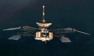
Mariner 4 was launched on Nov. 28, 1964 and made its closest approach to Mars on July 15, 1965. It took more than seven months to get to Mars. Mariner 4 weighed 574-pounds and had four solar panels.[1] [2] Besides taking the first close-up pictures of the Red Planet, it studied the solar wind for about three years in solar orbit after flying by Mars.[3] While studying the solar wind after the primary mission, Mariner may have been struck by micrometeorites. In a span of just 15 minutes, the cosmic dust detector registered 17 hits. The event changed the attitude of Mariner. On another occasion 83 micrometeorite hits in two days again changed the attitude which degraded the signal.[4]
Contents
Scientific Instruments
- Imaging system
- Helium magnetometer
- Plasma probe
- Cosmic-ray telescope
- Cosmic ray detector
- Cosmic dust detector.[5]
A close encounter
Mariner 4 spent just 25 minutes executing observations of Mars as it cruised by on July 14, 1965. In that brief time, it took 21 full pictures that it beamed back to Earth the next day. Nineteen pictures were taken along a swath that started at latitude 40 degrees S, Longitude 96 degrees W and ended at 40 degrees N and 187 degrees W.[6] Some pictures were taken between Mare Cimmerium and Mare Sinenum. The InSight mission landed in the region known as Elysium; Mariner 4 took pictures just to the East of Elysium.[7]
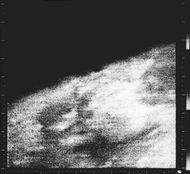
First close-up image ever taken of Mars Centered at 37 degrees N and 187 degrees W, picture displays an area about 330 km across by 1200 km from limb to bottom of frame. Location is near the boundary of Elysium Planitia to the west and Arcadia Planitia to the east. The hazy area barely visible above the limb on the left side of the image may be clouds.
Spacecraft
The spacecraft had a mass of 260.68 kg and an overall height of 289 cm. It carried both a low-gain omnidirectional antenna, as well as a high gain parabolic antenna with a diameter of 116.8 cm. A magnetometer was mounted on the low gain antenna so it would not be very affected by the body of the craft.[8] Power for Mariner 4 came from 28,224 solar cells that were capable of generating 310 watts at Mars. In addition, a rechargeable 1200 W·h silver-oxide battery was employed. Propulsion was provided by monopropellant hydrazine, while attitude adjustment was carried out with 3 gyros and by blowing out nitrogen gas from jets located at the ends of the solar panels.[9] A solar vane that tapped the pressure of sunlight to stabilize the spacecraft was attached to the end of each solar panel.[10] [11] Before Mariner 4, spacecraft were able to find their positions in space by sighting the Earth or its target. Mariner 4 utilized sun and star sensors. To find its location, Mariner first found the sun, and then it rotated until sighting the bright star Canopus. Scientists chose to use Canopus because it was so bright (second only to Sirius) and that it was near the south ecliptic pole.[12] A few times the star sensor locked onto different objects, so the procedure required a bit of tweaking. After Mariner 4, Canopus was used for many other missions.[13] [14] [15] Canopus is the brightest star in the constellation Carina (the old ship Argo). Carina is visible in the southern hemisphere and is near the Small Cloud of Magellan.[16] Temperatures in space can be very high and very low depending on whether you are in the sun or shade. Temperatures on various parts of the spacecraft were managed with different colored paint, aluminized Maylar plastic, fiberglass, and thermal-control louvers. These louvers kept the electronics between 55 and 85 degrees F, by opening and closing. Bimetallic strips, like the ones in home thermostats, controlled them. [17]
Camera
Mariner IV pictures taken in 1965 had a resolution of two miles.[18] It’s camera had a focal length of 305 millimeters. Images were about 300 kilometers across. About 240,000 bits were in each picture, as compared to about a million per picture for a television picture at the time. [19] Each picture contained 200 lines that each contained 200 pixels. At a rate of 8.33 bits/second, it took 4 days to transmit the images to Earth. [20]
Accomplishments
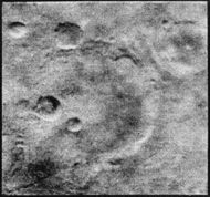
We learned some significant facts with Mariner. One of the biggest discoveries by Mariner 4 was that the Martian surface was covered with craters. Most astronomers and the public had not expected that. The 70 craters seen ranged from 5 to 120 Km across. However, the pictures only covered 1 % of the planet’s surface area.[21] [22] Of great significance was that no magnetic field was detected. The lack of a magnetic field meant that solar and cosmic radiation would rain down on the surface potentially destroying any life forms. Also, the thin atmosphere that was measured by radio waves passing through the atmosphere greatly reduced the chance of any liquid water.[23] The atmosphere only has a pressure of 4.1 to 7.0 mbar, compared to the normal 1013 mbar of the Earth. So, its air is only 1% the density of our Earth.[24] Before this mission, scientists thought that the air on Mars was mostly nitrogen (72%) as the Earth. But, Mars contains very little nitrogen or oxygen. Consequently, the scientific community was in shock over the findings of Mariner 4.[25] In the 1960’s most people wondered about the famous canals that some astronomers observed through telescopes.[26] Most astronomers thought they were some type of optical illusion. One astronomer quipped, “The smaller the telescope the more canals were claimed.” [27] Although no canals were seen in any of Mariner’s pictures, only 1% of the surface was photographed. One could say that you missed them. The existence of canals was put to rest by the much more extensive coverage of Mariner 6 and 7. [28] [29]
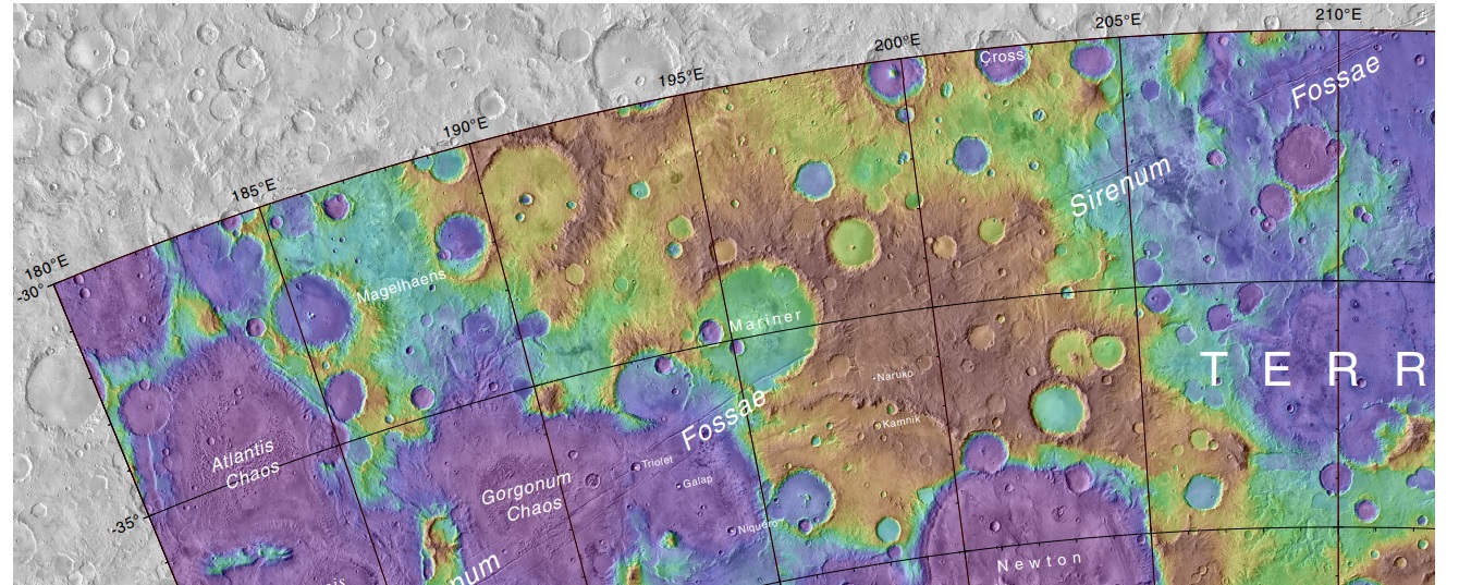
Map showing Mariner Crater and other nearby features. Mariner Crater was named after Mariner 4 which imaged the crater in 1965. Colors relate to elevations.
Implications of Results
The extremely tenuous atmosphere was unexpected. Immediately, scientists had to cancel plans for a landing in 1967--new landing systems needed to be developed to cope with such a thin atmosphere. Of course, the prospect for life on Mars was greatly diminished by this finding.[30] Over the decades since Mariner 4, much has been learned about conditions on Mars from both lander and orbiter instruments. On one hand, after the entire surface was imaged, we discovered features that looked like streams, rivers, and lakes. There is also much evidence for an ocean. Drainage systems in some regions point to precipitation as a cause. Clearly, these must have formed when Mars was different than the present. Studies of the upper atmosphere with satellites orbiting Mars have suggested that much of the atmosphere of Mars has escaped into space. Huge amounts of atmospheric gases have been swept away by the solar wind by various processes.[31] [32] This would not have occurred if Mars has a magnetic field as strong as our Earth’s. Radiation at the surface is relatively high. It would be difficult for organisms to live on today’s surface. However, a large, complex biomass could thrive under ground. A meter or so of dirt could eliminate much of the radiation. [33] [34] Future colonies would need protection from radiation such as a cover of dirt or in lava tunnels. A major mystery still exists around how water eroded features could form on Mars. Mars is farther from the sun than the Earth. Also, it’s believed that the sun was not as strong in the past when rivers carved channels.[35] [36] Climate models indicate that temperatures may not have even been above the freezing point of water. Alternative models have been suggested for the origin of channels. Impacts may have melted ground ice and or changed the weather near the impact site. [37] [38] [39] [40] [41] [42] Maybe, water just flowed under thick ice sheets. [43]
References
- ↑ https://www.jpl.nasa.gov/missions/mariner-4/
- ↑ https://www.space.com/18787-mariner-4.html
- ↑ https://www.jpl.nasa.gov/missions/mariner-4/
- ↑ https://nssdc.gsfc.nasa.gov/nmc/spacecraft/display.action?id=1964-077A
- ↑ https://www.jpl.nasa.gov/missions/mariner-4/
- ↑ Kieffer, H., et al. (eds) 1992. Mars. The University of Arizona Press. Tucson
- ↑ Glasstone, S. 1968. The Book of Mars. NASA. Washington D.C.
- ↑ https://nssdc.gsfc.nasa.gov/nmc/spacecraft/display.action?id=1964-077A
- ↑ https://ntrs.nasa.gov/archive/nasa/casi.ntrs.nasa.gov/19650018349.pdf
- ↑ http://www.planetary.org/multimedia/space-images/spacecraft/mariner-4.html
- ↑ Report from Mars Mariner IV 1964-1965. JPL.
- ↑ Glasstone, S. 1968. The Book of Mars. NASA. Washington D.C.
- ↑ https://ntrs.nasa.gov/archive/nasa/casi.ntrs.nasa.gov/19650018349.pdf
- ↑ http://home.earthlink.net/~nbrass1/mariner/miv.htm
- ↑ http://adsabs.harvard.edu/abs/1970ApOpt...9.1056G
- ↑ Bernhard, H., et al. 1948. New Handbook of the Heavens. The New American Library. N.Y.
- ↑ Report from Mars Mariner IV 1964-1965. JPL.
- ↑ https://ntrs.nasa.gov/archive/nasa/casi.ntrs.nasa.gov/19690007929.pdf
- ↑ Leighton, R. 1970. The Surface of Mars. Scientific American: 222 (number 5 May), 26-41
- ↑ Kieffer, H., et al. (eds) 1992. Mars. The University of Arizona Press. Tucson
- ↑ https://www.nasa.gov/image-feature/mariner-4-image-of-mars
- ↑ Kieffer, H., et al. (eds) 1992. Mars. The University of Arizona Press. Tucson
- ↑ https://nssdc.gsfc.nasa.gov/nmc/spacecraft/display.action?id=1964-077A
- ↑ https://www.khanacademy.org/partner-content/nasa/searchingforlife/mars-modern-exploration/a/mariner-4
- ↑ Document NASA-TM-X-56223, presented at the Symposium on Extraterrestrial Biology and Organic Chemistry, Warsaw, June 3-12, 1963
- ↑ Morton, O. 2002. Mapping Mars. Picador. N.Y.
- ↑ Report from Mars Mariner IV 1964-1965. JPL.
- ↑ https://ntrs.nasa.gov/archive/nasa/casi.ntrs.nasa.gov/19700009038.pdf
- ↑ https://nssdc.gsfc.nasa.gov/planetary/mars/mariner.html
- ↑ Kieffer, H., et al. (eds) 1992. Mars. The University of Arizona Press. Tucson
- ↑ Villanueva, G., et al. 2015. Strong water isotopic anomalies in the Martian atmosphere: Probing current and ancient reservoirs. Science 10 Apr 2015:Vol. 348, Issue 6231, pp. 218-221
- ↑ http://www.sci-news.com/space/maven-martian-atmosphere-lost-space-04750.html
- ↑ Dartnell, L. R.; Desorgher, L.; Ward, J. M.; Coates, A. J. (2007). "Modelling the surface and subsurface Martian radiation environment: Implications for astrobiology". Geophysical Research Letters. 34 (2): L02207.
- ↑ Hassler, Donald M.; Zeitlin, C; et al. (January 24, 2014). "Mars' Surface Radiation Environment Measured with the Mars ScienceLaboratory's Curiosity Rover" (PDF). Science. 343 (6169): 1244797.
- ↑ Forget et al. 2013. 3D modelling of the early martian climate under a denser CO2 atmosphere: Temperatures and CO2 ice clouds. Icarus 222, 81-99.
- ↑ Wordsworth et al. 2013. Global modelling of the early martian climate under a denser CO atmosphere: Water cycle and ice evolution. Icarus 222, 1-19.
- ↑ Newsome, H.E. (1980), Hydrothermal alteration of impact melt sheets with implications for Mars, Icarus, 44, 207-16.
- ↑ Mangold, N., V. Ansan, P. Masson, C. Quantin, and G. Neukum. 2008. Geomorphic study of fluvial landforms on the northern Valles Marinerisplateau, Mars, J. Geophys. Res., 113, E08009, doi:10.1029/2007JE002985.
- ↑ Segura, T. L., O. B. Toon, and T. Colaprete. 2008. Modeling the environmentaleffects of moderate‐sized impacts on Mars, J. Geophys. Res., 113,E11007, doi:10.1029/2008JE003147
- ↑ Segura, T. L., O. B. Toon, T. Colaprete, and K. Zahnle. 2002. Environmental Effects of Large Impacts on Mars, Science, 298, 1977–1980. doi:10.1126/science.1073586
- ↑ Kraal, E. R., M. van Dijk, G. Postma, and M. G. Kleinhans 2008b. Martian stepped‐delta formation by rapid water release, Nature, 451. 973–976, doi:10.1038/nature06615
- ↑ Toon, O. B., T. Segura, and K. Zahnle. 2010. The formation of Martian river valleys by impacts, Annu. Rev. Earth Planet. Sci., 38, 303–322. doi:10.1146/annurev-earth-040809-152354
- ↑ Squyres, S.W., and Kasting, J.F. 1994. Early Mars: How warm and how wet?, Science, 265, 744-8.
See Also
Recommended reading
Science: 149 (Number 3689). September 10, 1965. Contains 6 papers on the initial results of Mariner 4 one month after Mars encounter. Glasstone, S. 1968. The Book of Mars. NASA. Washington D.C. Morton, O. 2002. Mapping Mars. Picador. N.Y.


