File:Topographic Map of Gale Crater.jpg
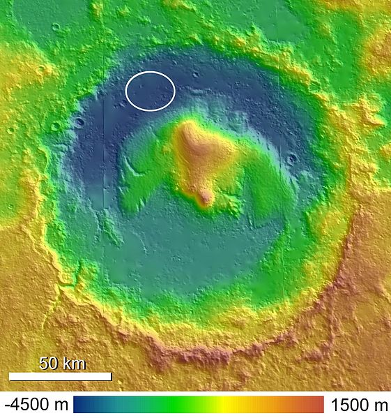
Revision as of 16:46, 25 January 2019 by Suitupandshowup (talk | contribs) (A shaded and colorized topographic map of Gale Crater, Mars, based on publicly released High Resolution Stereo Camera (HRSC) data. The MSL landing ellipse is indicated in the northwestern crater floor. Date 14 September 2010 Source Anderson and Bell,...)
No higher resolution available.
Topographic_Map_of_Gale_Crater.jpg (561 × 599 pixels, file size: 94 KB, MIME type: image/jpeg)
Summary
A shaded and colorized topographic map of Gale Crater, Mars, based on publicly released High Resolution Stereo Camera (HRSC) data. The MSL landing ellipse is indicated in the northwestern crater floor.
Date 14 September 2010 Source Anderson and Bell, 2010 Author Ryan Anderson
Licensing
Creative Commons Attribution-ShareAlike 4.0 (More Details)
File history
Click on a date/time to view the file as it appeared at that time.
| Date/Time | Thumbnail | Dimensions | User | Comment | |
|---|---|---|---|---|---|
| current | 16:46, 25 January 2019 | | 561 × 599 (94 KB) | Suitupandshowup (talk | contribs) | A shaded and colorized topographic map of Gale Crater, Mars, based on publicly released High Resolution Stereo Camera (HRSC) data. The MSL landing ellipse is indicated in the northwestern crater floor. Date 14 September 2010 Source Anderson and Bell,... |
You cannot overwrite this file.
File usage
The following 3 pages use this file:


