Difference between revisions of "Elysium quadrangle"
m (→Layers) |
m (→Layers) |
||
| Line 66: | Line 66: | ||
Image:Layers in Monument Valley.jpg|Layers in Monument Valley. These are accepted as being formed, at least in part, by water deposition. Since Mars contains similar layers, water remains as a major cause of layering on Mars. | Image:Layers in Monument Valley.jpg|Layers in Monument Valley. These are accepted as being formed, at least in part, by water deposition. Since Mars contains similar layers, water remains as a major cause of layering on Mars. | ||
| − | |||
| − | |||
ESP 046136 1960layers.jpg|Layers around base of mound, as seen by HiRISE under [[HiWish program]] | ESP 046136 1960layers.jpg|Layers around base of mound, as seen by HiRISE under [[HiWish program]] | ||
Revision as of 11:34, 28 February 2020
| MC-15 | Elysium | 0–30° N | 135–180° E | Quadrangles | Atlas |


This quadrangle was named after Elysium, a place of reward (Heaven), according to Homer in the Odyssey.[1]
The Elysium quadrangle covers the area between 180° to 225° west longitude and 0° to 30° north latitude on Mars. A small part of the Medusae Fossae Formation lies in this quadrangle. Eddie, Lockyer, and Tombaugh are the largest craters in the Elysium quadrangle. Elysium Mons and Albor Tholus are large volcanoes in this quadrangle. Just outside the boundaries of Elysium quadrangle sits another large volcano called Hecates. There are possible giant river valleys in this area. Athabasca Valles may be one of the youngest on the planet. A large lake may once have existed in the south near Lethe Valles and Athabasca Valles.[2]
The InSight lander touched down in the southern part of this quadrangle in 2018 and is now gathering data especially on Marsquakes.
Contents
Volcanoes
The area near the volcanoes of Elysium is covered with lava flows. On close examination, some flows can even be seen to approach and then stop when reaching higher ground. (See pictures below for examples) The top of a lava flow often cools quickly , forming a hard crust, but it still moves under the crust. Such movement breaks up the top layer making it very rough.[3] Such rough flow is called aa lava. The lava flows here are of the aa variety.
Some places in the Elysium quadrangle are young geological. Some researchers call them Platy-Ridged-Polygonized terrain. The surface of this terrain has been suggested to be pack ice, basalt lava, or muddy flows. HiRISE images show the heights of the surface ridges to be usually less than 2 meters. This is far less than what is expected from lava flows. In addition the high resolution photos of HiRISE indicates that the surface appears to flow. This would not occur with pack ice. So, the researchers concluded that muddy flows cover the surface.[4] For a while, many believed the surface was made of ice flows, which it resembles.

Lava flow in Elysium. There are many lava flows in Elysium. In this one, the lava flowed toward the upper right. Image taken by Mars Global Surveyor, under the MOC Public Targeting Program.
Lava flow, as seen by HiRISE under HiWish program Dark slope streaks are also visible

Lava flows in Elysium as seen by HiRISE. Upper part of image shows lava that solidified on the top then crumpled as lava still moved.

Lava flow, as seen by HiRISE under HiWish program

Lava rafts, as seen by HiRISE under HiWish program


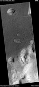
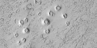
Rootless cones
"Rootless cones" are caused by explosions of lava with ground ice under a hot lava flow.[5] [6] [7] The ice melts and turns into a vapor and creates a cone or ring. These cones are found in Iceland, in places where lava covers water-saturated ground.[8] [9] [10]

Wide view of field of rootless cones

Close view of field of rootless cones, as seen by HiRISE under HiWish program

Rootless Cones, as seen by HiRISE. The chains of rings caused by lava interacting with water ice.

Rootless Cones, as seen by HiRISE under HiWish program
Close view of cones These cones formed when hot lava flowed over ice-rich ground.


Layers
Some regions in the Elysium quadrangle display strata or layers. Some layers break up into fine particles, other layers break up into large boulders due to their hardness. These boulders are probably made of the volcanic rock basalt since it is hard and is widespread on Mars. Some layers may be caused by repeated flows of lava.
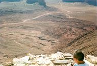
Layers in Monument Valley. These are accepted as being formed, at least in part, by water deposition. Since Mars contains similar layers, water remains as a major cause of layering on Mars.

Layers around base of mound, as seen by HiRISE under HiWish program

Layers around streamlined knob, as seen by HiRISE under HiWish program

Layered mound with streaks, as seen by HiRISE under HiWish program

Close view of layers on crater wall, as seen by HiRISE under HiWish program


References
- ↑ Blunck, J. 1982. Mars and its Satellites. Exposition Press. Smithtown, N.Y.
- ↑ "Cabrol, N 2010">Cabrol, N. and E. Grin (eds.). 2010. Lakes on Mars. Elsevier. NY.
- ↑ http://hirise.lpl.arizona.edu/PSP_010744_1840 | title=Southern Margin of Cerberus Palus (PSP_010744_1840) |
- ↑ Yue, Z., et al. 2017. AN INVESTIGATION OF THE HYPOTHESES FOR FORMATION OF THE PLATY-RIDGEDPOLYGONIZED TERRAIN IN ELYSIUM PLANITIA, MARS. Lunar and Planetary Science XLVIII (2017). 1770.pdf
- ↑ Keszthelyi, L. et al. 2010. Hydrovolcanic features on Mars: Preliminary observations from the first Mars year of HiRISE. Icarus: 205, 211-229. imaging
- ↑ http://www.psrd.hawaii.edu/June01/lavaIceMars.html
- ↑ Lanagan, P., A. McEwen, L. Keszthelyi, and T. Thordarson. 2001. Rootless cones on Mars indicating the presence of shallow equatorial ground ice in recent times, Geophysical Research Letters: 28, 2365-2368.
- ↑ S. Fagents1, A., P. Lanagan, R. Greeley. 2002. Rootless cones on Mars: a consequence of lava-ground ice interaction. Geological Society, Londo. Special Publications: 202, 295-317.
- ↑ http://www.psrd.hawaii.edu/June01/lavaIceMars.
- ↑ Jaeger, W., L. Keszthelyi, A. McEwen, C. Dundas, P. Russell, and the HiRISE team. 2007. EARLY HiRISE OBSERVATIONS OF RING/MOUND LANDFORMS IN ATHABASCA VALLES, MARS. Lunar and Planetary Science XXXVIII 1955.pdf.


