Difference between revisions of "Elysium quadrangle"
(→Troughs/pit craters: edited info) |
|||
| Line 93: | Line 93: | ||
File:55459 2080layersclose.jpg|Close view of layers in trough | File:55459 2080layersclose.jpg|Close view of layers in trough | ||
File:ESP 057555 1820concentricfractures.jpg|Concentric troughs, as seen by HiRISE under the HiWish program | File:ESP 057555 1820concentricfractures.jpg|Concentric troughs, as seen by HiRISE under the HiWish program | ||
| + | |||
| + | </gallery> | ||
| + | |||
| + | ==Craters== | ||
| + | |||
| + | Like nearly all of Mars, the surface of Elysium quadrangle contains numerous impact craters. The large numbers are from the extreme age of most of the Martian surface. Impact craters generally have a rim with ejecta around them; volcanic craters do not have a rim or ejecta deposits. As craters get larger (greater than 10 km in diameter) they usually possess a central peak.<ref>http://www.lpi.usra.edu/publications/slidesets/stones/</ref> The peak is caused by a rebound of the crater floor following the impact.<ref>Hugh H. Kieffer|title=Mars|url=https://books.google.com/books?id=NoDvAAAAMAAJ|accessdate=7 March 2011|year=1992|publisher=University of Arizona Press|</ref> Sometimes craters will display layers. The collision that produces a crater brings rocks from deep underground. Hence, craters can show us what lies deep under the surface. | ||
| + | |||
| + | |||
| + | <gallery class="center" widths="190px" heights="180px" > | ||
| + | Image:Thila Crater.JPG|[[Thila Crater]], as seen by HiRISE. Picture on right is an enlargement of a part of the other picture. Scale bar is 500 meters long. | ||
| + | Image:Mohawk Crater.JPG|[[Mohawk Crater]], as seen by HiRISE. Images to the right are enlargements. Far left image shows northern wall, part of crater floor, and the central uplift. Layers in the mantle layer are visible in the far right image. | ||
| + | Image:Persbo Crater Wall.JPG|[[Persbo Crater]] Wall, as seen by HiRISE. Scale bar is 500 meters long. Click on image to see details in rock layers in wall. | ||
| + | Image:Persbo Crater Foor.JPG|[[Persbo Crater]] Floor, as seen by HiRISE. Scale bar is 500 meters long. Impacts into floor reached a layer of light-toned materials. These materials were then thrown out over a slightly darker surface. Light-toned materials may be hydrated minerals like sulfate. | ||
| + | Image:Lockyer Crater.JPG|[[Lockyer Crater]] Central Hills, as seen by HiRISE. | ||
| + | Image:layers in Lockyer Crater.jpg|Layers in [[Lockyer Crater]], as seen by HiRISE under the [[HiWish program]] | ||
| + | Image:Dilly Crater.JPG|[[Dilly Crater]], as seen by HiRISE. | ||
| + | Image:Eddie Crater central peak.JPG|[[Eddie Crater]] central peak in Elysium quadrangle, as seen by HiRISE | ||
| + | Image:Lava flow and crater ejecta.JPG|Lava flow and crater ejecta, as seen by HiRISE. Impact penetrated into light-toned material then spread it on darker surface. Scale bar is 500 meters long. | ||
| + | Esp 036944 1810craters.jpg|Crater showing layers and small craters in the ejecta that show a thin ejecta pattern Image taken with HiRISE under HiWish program. | ||
| + | Wikitombaughwest.jpg|West side of [[Tombaugh (Martian crater)]], as seen by CTX camera (on [[Mars Reconnaissance Orbiter]]) | ||
| + | </gallery> | ||
| + | |||
| + | <gallery class="center" widths="190px" heights="180px" > | ||
| + | File:ESP 053981 2090ringmolds.jpg|Possible ring-mold craters on floor of large crater, as seen by HiRISE under the HiWish program | ||
| + | File:53981 2090ringmolds.jpg|Close view of possible ring-mold craters on floor of large crater, as seen by HiRISE under the HiWish program | ||
| + | |||
| + | File:ESP 054944 2085benchcrater.jpg|Crater with a bench, as seen by HiRISE under HiWish program | ||
| + | File:ESP 055234 1910oddcraters.jpg|Craters, layers, and streaks, as seen by HiRISE under HiWish program | ||
| + | File:55234 1910oddcraters.jpg|Close view of craters that just have ejecta on one side. Image acquired by HiRISE under HiWish program. | ||
</gallery> | </gallery> | ||
Revision as of 12:12, 28 February 2020
| MC-15 | Elysium | 0–30° N | 135–180° E | Quadrangles | Atlas |


This quadrangle was named after Elysium, a place of reward (Heaven), according to Homer in the Odyssey.[1]
The Elysium quadrangle covers the area between 180° to 225° west longitude and 0° to 30° north latitude on Mars. A small part of the Medusae Fossae Formation lies in this quadrangle. Eddie, Lockyer, and Tombaugh are the largest craters in the Elysium quadrangle. Elysium Mons and Albor Tholus are large volcanoes in this quadrangle. Just outside the boundaries of Elysium quadrangle sits another large volcano called Hecates. There are possible giant river valleys in this area. Athabasca Valles may be one of the youngest on the planet. A large lake may once have existed in the south near Lethe Valles and Athabasca Valles.[2]
The InSight lander touched down in the southern part of this quadrangle in 2018 and is now gathering data especially on Marsquakes.
Volcanoes
The area near the volcanoes of Elysium is covered with lava flows. On close examination, some flows can even be seen to approach and then stop when reaching higher ground. (See pictures below for examples) The top of a lava flow often cools quickly , forming a hard crust, but it still moves under the crust. Such movement breaks up the top layer making it very rough.[3] Such rough flow is called aa lava. The lava flows here are of the aa variety.
Some places in the Elysium quadrangle are young geological. Some researchers call them Platy-Ridged-Polygonized terrain. The surface of this terrain has been suggested to be pack ice, basalt lava, or muddy flows. HiRISE images show the heights of the surface ridges to be usually less than 2 meters. This is far less than what is expected from lava flows. In addition the high resolution photos of HiRISE indicates that the surface appears to flow. This would not occur with pack ice. So, the researchers concluded that muddy flows cover the surface.[4] For a while, many believed the surface was made of ice flows, which it resembles.

Lava flow in Elysium. There are many lava flows in Elysium. In this one, the lava flowed toward the upper right. Image taken by Mars Global Surveyor, under the MOC Public Targeting Program.
Lava flow, as seen by HiRISE under HiWish program Dark slope streaks are also visible

Lava flows in Elysium as seen by HiRISE. Upper part of image shows lava that solidified on the top then crumpled as lava still moved.

Lava flow, as seen by HiRISE under HiWish program

Lava rafts, as seen by HiRISE under HiWish program


Rootless cones
"Rootless cones" are caused by explosions of lava with ground ice under a hot lava flow.[5] [6] [7] The ice melts and turns into a vapor and creates a cone or ring. These cones are found in Iceland, in places where lava covers water-saturated ground.[8] [9] [10]

Wide view of field of rootless cones

Close view of field of rootless cones, as seen by HiRISE under HiWish program

Rootless Cones, as seen by HiRISE. The chains of rings caused by lava interacting with water ice.

Rootless Cones, as seen by HiRISE under HiWish program
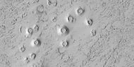
Close view of cones These cones formed when hot lava flowed over ice-rich ground.


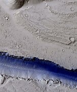
Layers
Some regions in the Elysium quadrangle display strata or layers. Some layers break up into fine particles, other layers break up into large boulders due to their hardness. These boulders are probably made of the volcanic rock basalt since it is hard and is widespread on Mars. Some layers may be caused by repeated flows of lava.
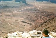
Layers in Monument Valley. These are accepted as being formed, at least in part, by water deposition. Since Mars contains similar layers, water remains as a major cause of layering on Mars.

Layers around base of mound

Layers around streamlined knob, as seen by HiRISE under HiWish program

Layered mound with streaks

Close view of layers, as seen by HiRISE under HiWish program

Close view of layers on crater wall


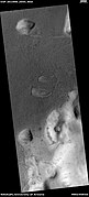
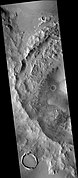
Troughs/pit craters
Long, narrow depressions are common on Mars. They are called troughs or fossae in the geographical language used for Mars. Troughs may be made when the crust is stretched until it breaks. The mass of the huge volcanoes can cause this stretching. Fossae and common in the Elysium quadrangle as are volcanoes. A trough often possesses two breaks or faults with a middle section moving down. This leaves steep cliffs along the sides and is called a graben.[11] Lake George, in northern New York State, is a lake inside a graben. Pits are often associated with troughs. Troughs often appear to begin as a line of pits. Pits result when material collapses into a void. Pits do not have rims or ejecta around them, like impact craters do.[12] There are other ideas for the formation of fossae and pits or pit craters as they are called. They may be connected to dikes of magma. Dikes form when magma moving underground travels upward along a fault or break in the rock. Magma might move along, under the surface, breaking the rock, and more importantly melting ice. The resulting action would cause a crack to form at the surface. The images below of the Cerberus Fossae, the Elysium Fossae and other troughs, as seen by HiRISE are examples of fossae.
Knowledge of the locations and formation mechanisms of pit craters and fossae is important for the future colonization of Mars because they may be hold water.[13]

The Elysium Fossae, as seen by HiRISE (scale bar is 500 m)

Troughs to the east of Albor Tholus
Portion of a trough (fossa) (blue indicates probably seasonal frost)[14]

Troughs showing layers and dark slope streaks, as seen by HiRISE under HiWish program

Trough

Close view of layers in trough

Concentric troughs, as seen by HiRISE under the HiWish program


Craters
Like nearly all of Mars, the surface of Elysium quadrangle contains numerous impact craters. The large numbers are from the extreme age of most of the Martian surface. Impact craters generally have a rim with ejecta around them; volcanic craters do not have a rim or ejecta deposits. As craters get larger (greater than 10 km in diameter) they usually possess a central peak.[15] The peak is caused by a rebound of the crater floor following the impact.[16] Sometimes craters will display layers. The collision that produces a crater brings rocks from deep underground. Hence, craters can show us what lies deep under the surface.

Thila Crater, as seen by HiRISE. Picture on right is an enlargement of a part of the other picture. Scale bar is 500 meters long.
- Mohawk Crater.JPG
Mohawk Crater, as seen by HiRISE. Images to the right are enlargements. Far left image shows northern wall, part of crater floor, and the central uplift. Layers in the mantle layer are visible in the far right image.
- Persbo Crater Wall.JPG
Persbo Crater Wall, as seen by HiRISE. Scale bar is 500 meters long. Click on image to see details in rock layers in wall.
- Persbo Crater Foor.JPG
Persbo Crater Floor, as seen by HiRISE. Scale bar is 500 meters long. Impacts into floor reached a layer of light-toned materials. These materials were then thrown out over a slightly darker surface. Light-toned materials may be hydrated minerals like sulfate.

Lockyer Crater Central Hills, as seen by HiRISE.

Layers in Lockyer Crater, as seen by HiRISE under the HiWish program

Dilly Crater, as seen by HiRISE.

Eddie Crater central peak in Elysium quadrangle, as seen by HiRISE

Lava flow and crater ejecta, as seen by HiRISE. Impact penetrated into light-toned material then spread it on darker surface. Scale bar is 500 meters long.

Crater showing layers and small craters in the ejecta that show a thin ejecta pattern Image taken with HiRISE under HiWish program.
West side of Tombaugh (Martian crater), as seen by CTX camera (on Mars Reconnaissance Orbiter)


Possible ring-mold craters on floor of large crater, as seen by HiRISE under the HiWish program

Close view of possible ring-mold craters on floor of large crater, as seen by HiRISE under the HiWish program

Crater with a bench, as seen by HiRISE under HiWish program

Craters, layers, and streaks, as seen by HiRISE under HiWish program

Close view of craters that just have ejecta on one side. Image acquired by HiRISE under HiWish program.


References
- ↑ Blunck, J. 1982. Mars and its Satellites. Exposition Press. Smithtown, N.Y.
- ↑ "Cabrol, N 2010">Cabrol, N. and E. Grin (eds.). 2010. Lakes on Mars. Elsevier. NY.
- ↑ http://hirise.lpl.arizona.edu/PSP_010744_1840 | title=Southern Margin of Cerberus Palus (PSP_010744_1840) |
- ↑ Yue, Z., et al. 2017. AN INVESTIGATION OF THE HYPOTHESES FOR FORMATION OF THE PLATY-RIDGEDPOLYGONIZED TERRAIN IN ELYSIUM PLANITIA, MARS. Lunar and Planetary Science XLVIII (2017). 1770.pdf
- ↑ Keszthelyi, L. et al. 2010. Hydrovolcanic features on Mars: Preliminary observations from the first Mars year of HiRISE. Icarus: 205, 211-229. imaging
- ↑ http://www.psrd.hawaii.edu/June01/lavaIceMars.html
- ↑ Lanagan, P., A. McEwen, L. Keszthelyi, and T. Thordarson. 2001. Rootless cones on Mars indicating the presence of shallow equatorial ground ice in recent times, Geophysical Research Letters: 28, 2365-2368.
- ↑ S. Fagents1, A., P. Lanagan, R. Greeley. 2002. Rootless cones on Mars: a consequence of lava-ground ice interaction. Geological Society, Londo. Special Publications: 202, 295-317.
- ↑ http://www.psrd.hawaii.edu/June01/lavaIceMars.
- ↑ Jaeger, W., L. Keszthelyi, A. McEwen, C. Dundas, P. Russell, and the HiRISE team. 2007. EARLY HiRISE OBSERVATIONS OF RING/MOUND LANDFORMS IN ATHABASCA VALLES, MARS. Lunar and Planetary Science XXXVIII 1955.pdf.
- ↑ http://hirise.lpl.arizona.edu/PSP_008641_2105
- ↑ Wyrick, D., D. Ferrill, D. Sims, and S. Colton. 2003. Distribution, Morphology and Structural Associations of Martian Pit Crater Chains. Lunar and Planetary Science XXXIV (2003)
- ↑ Ferrill, D., D. Wyrick, A. Morris, D. Sims, and N. Franklin. 2004. Dilational fault slip and pit chain formation on Mars 14:10:4-12
- ↑ https://www.uahirise.org/ESP_019033_2495
- ↑ http://www.lpi.usra.edu/publications/slidesets/stones/
- ↑ Hugh H. Kieffer|title=Mars|url=https://books.google.com/books?id=NoDvAAAAMAAJ%7Caccessdate=7 March 2011|year=1992|publisher=University of Arizona Press|


