Difference between revisions of "Fretted terrain"
Suitupshowup (talk | contribs) m (added image) |
Suitupshowup (talk | contribs) (added image) |
||
| Line 11: | Line 11: | ||
Fretted terrain in Ismenius Lacus quadrangle, seems to transition from narrow straight valleys to isolated mesas. Most of the mesas are surrounded by forms that have been given a variety of names: circum-mesa aprons, debris aprons, rock glaciers, and lobate debris aprons.<ref>[http://www.lpi.usra.edu/meetings/lpsc2000/pdf/1053.pdf 1053.PDF<!-- Bot generated title -->]</ref> <ref>Carr, M. 2006. The Surface of Mars. Cambridge University Press. {{ISBN|978-0-521-87201-0}}</ref><ref>Squyres, S. 1978. Martian fretted terrain: Flow of erosional debris. Icarus: 34. 600-613.</ref> At first, they appeared to resemble rock glaciers on Earth. But scientists could not be sure. Even after the [[Mars Global Surveyor]] (MGS) Mars Orbiter Camera (MOC) took a variety of pictures of fretted terrain, experts could not tell for sure if material was moving or flowing as it would in an ice-rich deposit (glacier).<ref name="photojournal.jpl.nasa.gov"/> | Fretted terrain in Ismenius Lacus quadrangle, seems to transition from narrow straight valleys to isolated mesas. Most of the mesas are surrounded by forms that have been given a variety of names: circum-mesa aprons, debris aprons, rock glaciers, and lobate debris aprons.<ref>[http://www.lpi.usra.edu/meetings/lpsc2000/pdf/1053.pdf 1053.PDF<!-- Bot generated title -->]</ref> <ref>Carr, M. 2006. The Surface of Mars. Cambridge University Press. {{ISBN|978-0-521-87201-0}}</ref><ref>Squyres, S. 1978. Martian fretted terrain: Flow of erosional debris. Icarus: 34. 600-613.</ref> At first, they appeared to resemble rock glaciers on Earth. But scientists could not be sure. Even after the [[Mars Global Surveyor]] (MGS) Mars Orbiter Camera (MOC) took a variety of pictures of fretted terrain, experts could not tell for sure if material was moving or flowing as it would in an ice-rich deposit (glacier).<ref name="photojournal.jpl.nasa.gov"/> | ||
| + | |||
| + | |||
| + | ===Cliffs=== | ||
| + | |||
| + | <gallery class="center" widths="190px" heights="180px"> | ||
| + | Image:Fretted terrain of Ismenius Lacus taken with MGS.JPG|Fretted terrain of Ismenius Lacus showing flat floored valleys and cliffs. Photo taken with Mars Orbiter Camera (MOC)on the [[Mars Global Surveyor]]. | ||
| + | |||
| + | Image:Steep cliff in Ismenius Lacus taken with MGS.JPG|Enlargement of the photo on the left showing cliff. Photo taken with high resolution camera of [[Mars Global Surveyor]] (MGS). | ||
| + | |||
| + | Wikictxp13clifflda.jpg|Wide view of mesa with CTX showing Cliff face and location of lobate debris apron (LDA). Location is [[Ismenius Lacus quadrangle]]. | ||
| + | Wikifretesp 028313 2220cliff.jpg|Enlargement of previous CTX image of mesa This image shows the cliff face and detail in the LDA. Image taken with HiRISE under HiWish program. Location is [[Ismenius Lacus quadrangle]]. | ||
| + | </gallery> | ||
| + | |||
| + | ===Lineated floor deposits=== | ||
| + | |||
| + | <gallery class="center" widths="190px" heights="180px"> | ||
| + | Wikifrettedctxp22.jpg|Wide CTX view showing mesa and buttes with lobate debris aprons and lineated valley fill around them. Location is [[Ismenius Lacus quadrangle]]. | ||
| + | WikiESP 020769 2225fretted.jpg|Close-up of [[lineated valley fill]] (LVF), as seen by HiRISE under HiWish program Note: this is an enlargement of the previous CTX image. | ||
| + | File:Reull Vallis lineated deposits.jpg|[[Reull Vallis]] with lineated floor deposits, as seen by [[THEMIS]]. Image located in [[Hellas quadrangle]]. Click on image to see relationship to other features. | ||
| + | |||
| + | Image:Coloe Fossae Lineated Valley Fill.JPG|[[Coloe Fossae]] [[Lineated valley fill]], as seen by [[HiRISE]]. Scale bar is 500 meters long. | ||
| + | </gallery> | ||
Eventually, proof of their true nature was discovered when radar studies with the [[Mars Reconnaissance Orbiter]] showed that they contained pure water ice covered with a thin layer of rocks that insulated the ice.<ref>http://www.planetary.brown.edu/pdfs/3733.pdf {{Bare URL PDF|date=March 2022}}</ref> <ref>Head, J. et al. 2005. Tropical to mid-latitude snow and ice accumulation, flow and glaciation on Mars. Nature: 434. 346-350</ref><ref>[https://archive.today/20121205041820/http://www.marstoday.com/news/viewpr.html?pid=18050 Mars' climate in flux: Mid-latitude glaciers | Mars Today - Your Daily Source of Mars News<!-- Bot generated title -->]</ref> <ref>[http://news.brown.edu/pressreleases/2008/04/martian-glaciers Glaciers Reveal Martian Climate Has Been Recently Active | Brown University News and Events<!-- Bot generated title -->]</ref> <ref>Plaut, J. et al. 2008. Radar Evidence for Ice in Lobate Debris Aprons in the Mid-Northern Latitudes of Mars. Lunar and Planetary Science XXXIX. 2290.pdf</ref><ref>Holt, J. et al. 2008. Radar Sounding Evidence for Ice within Lobate Debris Aprons near Hellas Basin, Mid-Southern Latitudes of Mars. Lunar and Planetary Science XXXIX. 2441.pdf</ref> | Eventually, proof of their true nature was discovered when radar studies with the [[Mars Reconnaissance Orbiter]] showed that they contained pure water ice covered with a thin layer of rocks that insulated the ice.<ref>http://www.planetary.brown.edu/pdfs/3733.pdf {{Bare URL PDF|date=March 2022}}</ref> <ref>Head, J. et al. 2005. Tropical to mid-latitude snow and ice accumulation, flow and glaciation on Mars. Nature: 434. 346-350</ref><ref>[https://archive.today/20121205041820/http://www.marstoday.com/news/viewpr.html?pid=18050 Mars' climate in flux: Mid-latitude glaciers | Mars Today - Your Daily Source of Mars News<!-- Bot generated title -->]</ref> <ref>[http://news.brown.edu/pressreleases/2008/04/martian-glaciers Glaciers Reveal Martian Climate Has Been Recently Active | Brown University News and Events<!-- Bot generated title -->]</ref> <ref>Plaut, J. et al. 2008. Radar Evidence for Ice in Lobate Debris Aprons in the Mid-Northern Latitudes of Mars. Lunar and Planetary Science XXXIX. 2290.pdf</ref><ref>Holt, J. et al. 2008. Radar Sounding Evidence for Ice within Lobate Debris Aprons near Hellas Basin, Mid-Southern Latitudes of Mars. Lunar and Planetary Science XXXIX. 2441.pdf</ref> | ||
Revision as of 07:55, 8 January 2024
Fretted terrain is a type of surface feature common to certain areas of Mars and was discovered in Mariner 9 images. It lies between two different types of terrain. The surface of Mars can be divided into two parts: low, young, uncratered plains that cover most of the northern hemisphere, and high-standing, old, heavily cratered areas that cover the southern and a small part of the northern hemisphere. Between these two zones is a region called the Martian dichotomy and parts of it contain fretted terrain.
This terrain contains a complicated mix of cliffs, mesas, buttes, and straight-walled and curved canyons.[1] It contains smooth, flat lowlands along with steep cliffs. The scarps or cliffs are usually 1 to 2 km high. Channels in the area have wide, flat floors and steep walls.[2] Fretted terrain shows up in northern Arabia Terra and in Aeolis Mensae.[3] [4] Two good examples of fretted terrain are Deuteronilus Mensae and Protonilus Mensae.

Fretted terrain showing steep walled buttes and mesas

Fretted terrain in Ismenius Lacus quadrangle, seems to transition from narrow straight valleys to isolated mesas. Most of the mesas are surrounded by forms that have been given a variety of names: circum-mesa aprons, debris aprons, rock glaciers, and lobate debris aprons.[5] [6][7] At first, they appeared to resemble rock glaciers on Earth. But scientists could not be sure. Even after the Mars Global Surveyor (MGS) Mars Orbiter Camera (MOC) took a variety of pictures of fretted terrain, experts could not tell for sure if material was moving or flowing as it would in an ice-rich deposit (glacier).[4]
Cliffs

Fretted terrain of Ismenius Lacus showing flat floored valleys and cliffs. Photo taken with Mars Orbiter Camera (MOC)on the Mars Global Surveyor.

Enlargement of the photo on the left showing cliff. Photo taken with high resolution camera of Mars Global Surveyor (MGS).
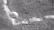
Wide view of mesa with CTX showing Cliff face and location of lobate debris apron (LDA). Location is Ismenius Lacus quadrangle.
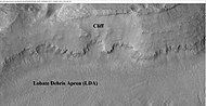
Enlargement of previous CTX image of mesa This image shows the cliff face and detail in the LDA. Image taken with HiRISE under HiWish program. Location is Ismenius Lacus quadrangle.


Lineated floor deposits
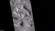
Wide CTX view showing mesa and buttes with lobate debris aprons and lineated valley fill around them. Location is Ismenius Lacus quadrangle.

Close-up of lineated valley fill (LVF), as seen by HiRISE under HiWish program Note: this is an enlargement of the previous CTX image.

Reull Vallis with lineated floor deposits, as seen by THEMIS. Image located in Hellas quadrangle. Click on image to see relationship to other features.

Coloe Fossae Lineated valley fill, as seen by HiRISE. Scale bar is 500 meters long.


Eventually, proof of their true nature was discovered when radar studies with the Mars Reconnaissance Orbiter showed that they contained pure water ice covered with a thin layer of rocks that insulated the ice.[8] [9][10] [11] [12][13]
Besides rock-covered glaciers around mesas, the region had many steep-walled valleys with lineations—ridges and grooves—on their floors. The material comprising these valley floors is called lineated valley fill. In some of the best images taken by the Viking Orbiters, some of the valley fill appeared to resemble alpine glaciers on Earth. Given this similarity, some scientists assumed that the lineations on these valley floors might have formed by flow of ice in (and perhaps through) these canyons and valleys. Today it is generally agreed that glacial flow caused the lineations.[14] [15]
Fretted terrain in Aeolis Mensae is similar to that of Arabia Terra, but it lacks debris aprons and lineated valley fill. The Medusae Fossae Formation, a soft, layered material that is covered with yardangs surrounds parts of the fretted terrain in Aeolis Mensae.[3]
The origin of fretted plateau material is not completely understood.[16] [17] It does seem to contain fine-grained material, and it has an almost total lack of boulders. This material contrasts with most of the Martian surface which is covered with the igneous rock basalt. Basalt breaks into boulders and eventually into sand. It is thought that when plateau material breaks down, the small-sized particles can be easily carried away by the wind. Erosion of plateau material seems to be much faster than other materials on Mars.[3] Research presented in 2018 at a Lunar and Planetary Science Conference in Texas suggested that the erosion that formed fretted terrain was aided by water moving under the surface.[18]
See also
External links
References
- ↑ Sharp, R. 1973. Mars Fretted and chaotic terrains. J. Geophys. Res.: 78. 4073–4083
- ↑ name="Kieffer">Template:Cite book
- ↑ 3.0 3.1 3.2 Irwin, R., et al. 2004. Sedimentary resurfacing and fretted terrain development along the crustal dichotomy boundary, Aeolis Mensae, Mars. JOURNAL OF GEOPHYSICAL RESEARCH: 109, E09011, Template:Doi.
- ↑ 4.0 4.1 Catalog Page for PIA01502
- ↑ 1053.PDF
- ↑ Carr, M. 2006. The Surface of Mars. Cambridge University Press. Template:ISBN
- ↑ Squyres, S. 1978. Martian fretted terrain: Flow of erosional debris. Icarus: 34. 600-613.
- ↑ http://www.planetary.brown.edu/pdfs/3733.pdf Template:Bare URL PDF
- ↑ Head, J. et al. 2005. Tropical to mid-latitude snow and ice accumulation, flow and glaciation on Mars. Nature: 434. 346-350
- ↑ Mars' climate in flux: Mid-latitude glaciers | Mars Today - Your Daily Source of Mars News
- ↑ Glaciers Reveal Martian Climate Has Been Recently Active | Brown University News and Events
- ↑ Plaut, J. et al. 2008. Radar Evidence for Ice in Lobate Debris Aprons in the Mid-Northern Latitudes of Mars. Lunar and Planetary Science XXXIX. 2290.pdf
- ↑ Holt, J. et al. 2008. Radar Sounding Evidence for Ice within Lobate Debris Aprons near Hellas Basin, Mid-Southern Latitudes of Mars. Lunar and Planetary Science XXXIX. 2441.pdf
- ↑ http://planetary.brown.edu/pdfs/3129.pdf Template:Bare URL PDF
- ↑ Head, J., et al. 2006. Modification of the dichotomy boundary on Mars by Amazonian mid-latitude regional glaciation. GEOPHYSICAL RESEARCH LETTERS, VOL. 33, L08S03, Template:Doi.
- ↑ https://www-sciencedirect-com.wikipedialibrary.idm.oclc.org/science/article/pii/S0019103520305534#bb0075
- ↑ Brossier, J., et al. 2021. Reconstructing the infilling history within Robert Sharp crater, Mars: Insights from morphology and stratigraphy. Icarus. Volume 358. 114223
- ↑ Denton, C., J. Head. 2018. MAPPING THE FRETTED TERRAIN NORTH OF ARABIA TERRA, MARS: RESULTS AND IMPLICATIONS FOR DICHOTOMY BOUNDARY EVOLUTION. 49th Lunar and Planetary Science Conference 2018 (LPI Contrib. No. 2083). 1597.pdf


