Difference between revisions of "Noachis quadrangle"
(added pictures, info, and ref) |
|||
| Line 14: | Line 14: | ||
</gallery> | </gallery> | ||
[[Category: Mars Atlas]] | [[Category: Mars Atlas]] | ||
| + | |||
| + | The Noachis quadrangle covers the area from 30° to 65° south latitude and 300° to 360° west longitude (60-0 E). It lies between Argyre and Hellas, two giant impact basins on Mars. The Noachis quadrangle includes Noachis Terra and the western part of Hellas Planitia, classical names for regions on Mars. | ||
| + | Noachis is considered among the oldest regions on Mars since it is so densely covered with impact craters that ii. The oldest parts of Mars have the designation of “Noachian age." | ||
| + | In addition, many previously buried craters are now coming to the surface.<ref>http://themis.asu.edu/zoom-20040317a|title=Exhumed Crater (Released 17 March 2004)|author=Mars Space Flight Facility|date=17 March 2004|publisher=Arizona State University|</ref> Noachis' extreme age has allowed ancient craters to be filled, and once again become newly exposed. | ||
| + | Much of the surface in Noachis quadrangle shows a scalloped topography in which the disappearance of ground ice has left depressions.<ref>Lefort | first1 = A. | display-authors = etal | year = 2010 | title = Scalloped terrains in the Peneus and Amphitrites Paterae region of Mars as observed by HiRISE | url = | journal = Icarus | volume = 205 | issue = 1| pages = 259–268 | </ref> | ||
| + | The first piece of human technology to land on Mars landed (crashed) in the Noachis quadrangle. It was the Soviet's Mars 2 that crash landed at 44.2 S and 313.2 W|. It weighed about one ton. The automated craft attempted to land in a giant dust storm and in an area that has many dust devils.<ref>Hartmann, W. 2003. A Traveler's Guide to Mars. Workman Publishing. NY, NY.</ref> | ||
| + | ==Scalloped topography== | ||
| + | [[Image:Scalloped Terrain at Peneus Patera.JPG|thumb|Scalloped Terrain at [[Peneus Patera]], as seen by HiRISE. Scalloped terrain is common in some areas of Mars.]] | ||
| + | Certain regions of Mars display scalloped-shaped depressions. The depressions are believed to be the remains of an ice-rich mantle deposit. Scallops are created when ice sublimates from frozen soil.<ref>https://www.uahirise.org/PSP_004340_1235 | title=HiRISE | Scalloped Depressions in Peneus Patera (PSP_004340_1235)}}</ref> <ref>McEwen, A., et al. 2017. Mars The Pristine Beauty of the Red Planet. University of Arizona Press. Tucson.</ref> This mantle material probably fell from the air as ice formed on dust when the climate was different due to changes in the tilt of the Mars pole.<ref>doi=10.1038/nature02114 |pmid=14685228 |title=Recent ice ages on Mars |journal=Nature |volume=426 |issue=6968 |pages=797–802 |year=2003 |last1=Head |first1=James W. |last2=Mustard |first2=John F. |last3=Kreslavsky |first3=Mikhail A. |last4=Milliken |first4=Ralph E. |last5=Marchant |first5=David R. |</ref> The scallops are typically tens of meters deep and from a few hundred to a few thousand meters across. They can be almost circular or elongated. Some appear to have coalesced, thereby causing a large heavily pitted terrain to form. A study published in Icarus, found that the landforms of scalloped topography can be made by the subsurface loss of water ice by sublimation under current Martian climate conditions. This model predicts similar shapes when the ground has large amounts of pure ice, up to many tens of meters in depth.<ref> |doi=10.1016/j.icarus.2015.07.033 |title=Modeling the development of martian sublimation thermokarst landforms |journal=Icarus |volume=262 |pages=154–169 |year=2015 |last1=Dundas |first1=Colin M. |last2=Byrne |first2=Shane |last3=McEwen |first3=Alfred S. |https://zenodo.org/record/1259051/files/article.pdf </ref> | ||
| + | The process of producing the terrain may begin with sublimation from a crack because there are often polygon cracks where scallops form.<ref > Lefort, A.; et al. (2010). "Scalloped terrains in the Peneus and Amphitrites Paterae region of Mars as observed by HiRISE". Icarus. 205 (1): 259–268.</ref> | ||
| + | <gallery class="center" widths="190px" heights="180px" > | ||
| + | PSP 004340 1235scalloped.jpg|Scalloped topography, as seen by HiRISE | ||
| + | 4340 1235scalloped.jpg|Close view of scalloped topography, as seen by HiRISE | ||
| + | ESP 050715 1225devilsscallops.jpg|Scalloped topography, as seen by HiRISE under HiWish program [[Dust devil tracks]] are also visible. | ||
| + | ESP 050728 1210scalloped.jpg|Scalloped topography, as seen by HiRISE under HiWish program | ||
| + | </gallery> | ||
| + | == Dust Devil Tracks == | ||
| + | Many areas on Mars experience the passage of giant dust devils. A thin coating of fine bright dust covers most of the Martian surface. When a dust devil goes by it blows away the coating and exposes the underlying dark surface creating tracks. It does not take too much fine dust to cover those tracks--experiments in Earth laboratories demonstrate that only a few 10's of microns of dust will be enough. The width of a single human hair ranges from approximately 20 to 200 microns (μm); consequently, the dust that can cover dust devil tracks may only be the thickness of a human hair.<ref>https://en.wikipedia.org/wiki/Micrometre</ref> The pattern of the dust devil tracks have been shown to change every few months.<ref>http://mars.jpl.nasa.gov/spotlight/KenEdgett.html |title=Ken Edgett |date=2001 |publisher=National Aeronautics and Space Administration</ref> Dust devils have been seen from the ground and from orbit. They have even blown the dust off of the solar panels of the two Mars Exploration Rovers (Spirit and Opportunity), thereby greatly extending their lives.<ref>http://marsrovers.jpl.nasa.gov/gallery/press/spirit/20070412a.html|publisher=National Aeronautics and Space Administration</ref> The twin Rovers were designed to last for 3 months, instead they lasted many years with Opportunity lasting over 14 years. The pattern of the dust devil tracks have been shown to change every few months.<ref>https://web.archive.org/web/20111028015730/http://mars.jpl.nasa.gov/spotlight/kenEdgett.html |</ref> One study that combined data from the High Resolution Stereo Camera (HRSC) and the Mars Orbiter Camera (MOC) found that some large dust devils on Mars have a diameter of 700 meters and last at least 26 minutes.<ref>doi=10.1016/j.icarus.2011.06.011 |title=Multitemporal observations of identical active dust devils on Mars with the High Resolution Stereo Camera (HRSC) and Mars Orbiter Camera (MOC) |journal=Icarus |volume=215 |issue=1 |pages=358–369 |year=2011 |last1=Reiss |first1=D. |last2=Zanetti |first2=M. |last3=Neukum |first3=G. |</ref> The image below of Russel Crater shows changes in dust devil tracks over a period of only three months, as documented by HiRISE. Other Dust Devil Tracks are visible in the picture of Frento Vallis. | ||
| + | <gallery class="center" widths="190px" heights="180px" > | ||
| + | Image:Russel Crater Dust Devil Changes.JPG|[[Russell (Martian crater)|Russell Crater]] Dust Devil Changes, as seen by [[HiRISE]]. Click on image to see changes in dust devil tracks in just 3 months. | ||
| + | Image:Frento Vallis.JPG|[[Frento Vallis]], as seen by HiRISE. Click on image to see better view of [[Dust Devil Tracks]]. | ||
| + | </gallery> | ||
| + | ==Craters== | ||
| + | Impact craters generally have a rim with ejecta around them, in contrast volcanic craters usually do not have a rim or ejecta deposits. As craters get larger (greater than 10 km in diameter) they usually have a central peak.<ref>http://www.lpi.usra.edu/publications/slidesets/stones/ | title=Stones, Wind, and Ice: A Guide to Martian Impact Craters}}</ref> The peak is caused by a rebound of the crater floor following the impact.<ref>Hugh H. Kieffer|title=Mars|url=https://books.google.com/books?id=NoDvAAAAMAAJ|accessdate=7 March 2011|date=1992|publisher=University of Arizona Press|isbn=978-0-8165-1257-7</ref> Sometimes craters will display layers. Craters can show us what lies deep under the surface. | ||
| + | |||
| + | <gallery class="center" widths="190px" heights="180px" > | ||
| + | Image:Maunder Crater.JPG|[[Maunder Crater]], as seen by HiRISE. The overhang is part of the degraded south (toward bottom) wall of crater. The scale bar is 500 meters long. | ||
| + | Image:Asimov Crater.jpg|[[Asimov Crater]], as seen by HiRISE. Bottom of picture shows southeastern wall of crater. Top of picture is edge of mound that fills most of the crater. | ||
| + | Image:Asimov Crater Layers.jpg|Layers in west slope of Asimov Crater, as seen by HiRISE. | ||
| + | Image:Asimov Layers Close-up.JPG|Close-up of layers in west slope of Asimov Crater. Shadows show the overhang. Some of the layers are much more resistant to erosion, so they stick out. Image from HiRISE. | ||
| + | Image:Asimov Crater Central Pit.jpg|East Slope of Central Pit in Asimov Crater, as seen by HiRISE. Click on image to see more details of the many gullies. | ||
| + | Image:Kaiser Crater.JPG|[[Kaiser Crater]] (large crater in upper part of image)context for [[THEMIS]] image. | ||
| + | Image:Kaiser Crater.jpg|Detail of south wall of Kaiser Crater, as seen by THEMIS. Top of image shows part of a dune field. | ||
| + | Image:Rabe Crater Floor.JPG|[[Rabe Crater]] Floor, as seen by [[HiRISE]]. Click on image to see layers. Dark sand that made the dunes was probably blown in from elsewhere. | ||
| + | Image:Exhumed crater in Noachis.JPG|Crater that was buried in another age and is now being exposed by erosion, as seen by the [[Mars Global Surveyor]], under the [[MOC Public Targeting Program]]. | ||
| + | Image:24396floor.jpg|Floor of crater in Noachis quadrangle, as seen by HiRISE under [[HiWish program]]. | ||
| + | ESP 035632 1490noachiscraterfloor.jpg|Erosion forms on floor of crater, as seen by HiRISE under HiWish program | ||
| + | Wikileverrier.jpg|[[Le Verrier (Martian Crater)]], as seen by CTX camera (on Mars Reconnaissance Orbiter) | ||
| + | </gallery> | ||
| + | |||
| + | ==Sand Dunes== | ||
| + | When there are perfect conditions for producing sand dunes, steady wind in one direction and just enough sand, a barchan sand dune forms. Barchans have a gentle slope on the wind side and a much steeper slope on the lee side where horns or a notch often forms.<ref>Pye|first=Kenneth|title=Aeolian Sand and Sand Dunes|year=2008|publisher=Springer|isbn=9783540859109|pages=138|</ref> One picture below shows a definite barchan. | ||
| + | |||
| + | <gallery class="center" widths="190px" heights="180px" > | ||
| + | Image:Dark dunes in Noachis.JPG|Dark dunes (probably [[basalt]]), in an intracrater dune field, Noachis. Picture from Mars Global Surveyor, under the [[MOC Public Targeting Program]]. | ||
| + | Image:Dunes Wide View.jpg|Wide view of dunes in Noachis, as seen by HiRISE. | ||
| + | Image:Close-up view of Dunes.jpg|Close-up View of dunes in previous image, as seen by HiRISE. Note how sand barely covers some boulders. | ||
| + | Image:Barchan in Noachis.jpg|[[Barchan]] sand dunes in the Hellespontus region, as seen by HiRISE. The horns point in the downwind direction. | ||
| + | Image:Proctor Crater Ripples and Dunes.JPG|[[Proctor Crater]] ripples and dunes, as seen by HiRISE. | ||
| + | ESP 046378 1415dunes.jpg|Wide view of a field of sand dunes, as seen by HiRISE under HiWish program | ||
| + | 46378 1415dunes.jpg|Close view of sand dunes, as seen by HiRISE under HiWish program A birchen dune is labeled. | ||
| + | 46378 1415dunes2.jpg|Close view of sand dunes, as seen by HiRISE under HiWish program | ||
| + | 46378 1415dunes3.jpg|Close view of sand dunes, as seen by HiRISE under HiWish program A birchen dune is labeled. | ||
| + | ESP 046378 1415dunescolor.jpg|Close, color view of sand dunes, as seen by HiRISE under HiWish program | ||
| + | File:55097 1455dunescolor.jpg|Close, color view of dome sand dunes, as seen by HiRISE under HiWish program | ||
| + | </gallery> | ||
| + | ==Gullies== | ||
| + | Gullies on steep slopes are found in certain regions of Mars. Many ideas have been advanced to explain them. Formation by running water when the climate was different is a popular idea. Recently, because changes in gullies have been seen since HiRISE has been orbiting Mars, it is thought that they may be formed by chunks of dry ice moving down slope during spring time. Gullies are one of the most interesting discoveries made by orbiting space craft.<ref>http://www.jpl.nasa.gov/news/news.php?release=2014-226 | title=NASA Spacecraft Observes Further Evidence of Dry Ice Gullies on Mars</ref> <ref>http://hirise.lpl.arizona.edu/ESP_032078_1420 | title=HiRISE | Activity in Martian Gullies (ESP_032078_1420)</ref> <ref>http://www.space.com/26534-mars-gullies-dry-ice.html | title=Gullies on Mars Carved by Dry Ice, Not Water</ref> <ref>http://spaceref.com/mars/frosty-gullies-on-mars.html | title=Frosty Gullies on Mars - SpaceRef</ref> | ||
| + | <gallery class="center" widths="190px" heights="180px" > | ||
| + | ESP 037793 1445noachisgullies.jpg|Gullies on the wall of a crater, as seen by HiRISE under HiWish program | ||
| + | Image:Close-up of Asimov Crater.JPG|Gullies on mound in Asimov Crater, as seen by HiRISE | ||
| + | </gallery> | ||
| + | <gallery class="center" widths="190px" heights="180px" > | ||
| + | ESP 048159 1310gullies.jpg|Wide view of gullies and ridges in crater, as seen by HiRISE under HiWish program | ||
| + | |||
| + | 48159 1310gullychannels.jpg|Close view of gully channels, as seen by HiRISE under HiWish program Channels make some tight curves. | ||
| + | 48159 1310gullychannelsclose.jpg|Close view of gully channels, as seen by HiRISE under HiWish program Arrows point to small channel within larger channels. | ||
| + | </gallery> | ||
| + | |||
| + | <gallery class="center" widths="190px" heights="180px" > | ||
| + | File:ESP 055056 1420gulliesridges.jpg|Wide view of gullies, as seen by HiRISE under [[HiWish program]] | ||
| + | File:55056 1420gullies.jpg|Close view of gullies, as seen by HiRISE under HiWish program Channels show curves. | ||
| + | File:55056 1420gulliesclose.jpg|Close view of gullies, as seen by HiRISE under HiWish program Polygonal shapes are visible. | ||
| + | File:ESP 055227 1420crater.jpg|Crater with gullies, as seen by HiRISE under HiWish program | ||
| + | File:55227 1420gullies.jpg|Close view of gullies, as seen by HiRISE under HiWish program | ||
| + | </gallery> | ||
| + | ==Hellas floor features== | ||
| + | The Hellas floor contains some strange-looking features. One of these features is called "banded terrain."<ref>Diot, X., et al. 2014. The geomorphology and morphometry of the banded terrain in Hellas basin, Mars. Planetary and Space Science: 101, 118-134.</ref> <ref>http://www.nasa.gov/mission_pages/MRO/multimedia/20070717-2.html | title=NASA - Banded Terrain in Hellas</ref> <ref>http://hirise.lpl.arizona.edu/ESP_016154_1420 | title=HiRISE | Complex Banded Terrain in Hellas Planitia (ESP_016154_1420)</ref> This terrain has also been called "taffy pull" terrain, and it lies near honeycomb terrain, another strange surface.<ref>Bernhardt, H., et al. 2018. THE BANDED TERRAIN ON THE HELLAS BASIN FLOOR, MARS: GRAVITY-DRIVEN FLOW NOT SUPPORTED BY NEW OBSERVATIONS. 49th Lunar and Planetary Science Conference 2018 (LPI Contrib. No. 2083). 1143.pdf</ref> Banded terrain is found in the north-western part of the Hellas basin. This is the deepest part of the Hellas basin. The banded-terrain deposit displays an alternation of narrow band shapes and inter-bands. The sinuous nature and relatively smooth surface texture suggesting a viscous flow origin. A study published in Planetary and Space Science found that this terrain was the youngest deposit of the interior of Hellas. They also suggest in the paper that banded terrain may have covered a larger area of the NW interior of Hellas. The bands can be classified as linear, concentric, or lobate. Bands are typically 3–15 km long, 3 km wide. Narrow inter-band depressions are 65 m wide and 10 m deep.<ref>Complex geomorphologic assemblage of terrains in association with the banded terrain in Hellas basin, Mars |journal=Planetary and Space Science |volume=121 |pages=36–52 |year=2016 |last1=Diot |first1=X. |last2=El-Maarry |first2=M.R. |last3=Schlunegger |first3=F. |last4=Norton |first4=K.P. |last5=Thomas |first5=N. |last6=Grindrod |first6=P.M. |last7=Chojnacki |first7=M. |bibcode=2016P&SS..121...36D |url=https://boris.unibe.ch/74530/1/Diot_Schlunegger.pdf </ref> Pictures of these features can look like abstract art. | ||
| + | |||
| + | <gallery class="center" widths="190px" heights="180px" > | ||
| + | G18 025437 1406hellasbandssuperwide.jpg|Wide view of part of the floor of the Hellas basin, as seen by CTX | ||
| + | G18 025437 1406hellasbandswide.jpg|Wide view of Hellas basin floor, as seen by CTX. This is a slight enlargement of the previous image. The box shows the location of the next image that was taken with HiRISE. | ||
| + | ESP 033995 1410bands.jpg|Close-up of banded terrain on the floor of the Hellas basin, as seen by HiRISE Other, previous photos show wide views of this region. | ||
| + | Image:Twisted Terrain in Hellas Planitia.jpg|Twisted Terrain in [[Hellas Planitia]], but actually located in Noachis quadrangle. Imagine trying to walk across this. Image taken with HiRISE. | ||
| + | </gallery> | ||
| + | <gallery class="center" widths="190px" heights="180px" > | ||
| + | ESP 048830 1415ridges.jpg|Layered features on floor of [[Hellas Planitia]], as seen by HiRISE under HiWish program This may be an example of honeycomb terrain that is not yet completely understood. | ||
| + | </gallery> | ||
| + | <gallery class="center" widths="190px" heights="180px" > | ||
| + | File:ESP 055080 1425twistedbands.jpg|Twisted bands on the floor of Hellas Planitia, as seen by HiRISE under HiWish program | ||
| + | File:ESP 055212 1420taffypull.jpg|Twisted bands on the floor of Hellas Planitia, as seen by HiRISE under HiWish program These twisted bands are also called "taffy pull" terrain. | ||
| + | File:ESP 055146 1425ridges.jpg|Wide view of twisted bands on the floor of Hellas Planitia, as seen by HiRISE under HiWish program | ||
| + | File:55146 1425ridgesclosecolor.jpg|Close view of ridges in twisted bands, as seen by HiRISE under HiWish program | ||
| + | |||
| + | File:ESP 055001 1425honeycomb.jpg|Floor features in Hellas Planitia, as seen by HiRISE under HiWish program | ||
| + | File:ESP 055067 1420ridgenetwork.jpg|Floor features in Hellas Planitia, as seen by HiRISE under HiWish program | ||
| + | </gallery> | ||
| + | ==Gullies on Dunes== | ||
| + | Gullies are found on some dunes. These are somewhat different than gullies in other places, like the walls of craters. Gullies on dunes seem to keep the same width for a long distance and often just end with a pit, instead of an apron. Many of these gullies are found on dunes in Russell Crater. | ||
| + | <gallery class="center" widths="190px" heights="180px" > | ||
| + | ESP 020217 1255dunechannels.jpg|Wide view of dunes in Russell Crater, as seen by HiRISE Many narrow gullies are visible. | ||
| + | 20217 1255dunechannelsclose.jpg|Close view of the end of gullies in Russell Crater, as seen by HiRISE Note: These type of gullies do not usually end with an apron. | ||
| + | 20217 1255dunechannelsclosetop.jpg|Close view of the end of gullies in Russell Crater, as seen by HiRISE | ||
| + | ESP 020217 1255dunesclosecolor.jpg|Close, color view of the end of gullies in Russell Crater, as seen by HiRISE | ||
| + | </gallery> | ||
| + | ==Channels== | ||
| + | <gallery class="center" widths="190px" heights="180px" > | ||
| + | File:ESP 056981 1415channels.jpg|Channels, as seen by HiRISE under HiWish program | ||
| + | File:ESP 053698 1485channel.jpg|Channel, as seen by HiRISE under HiWish program | ||
| + | </gallery> | ||
| + | |||
| + | == Other scenes from Noachis quadrangle == | ||
| + | <gallery class="center" widths="190px" heights="180px" > | ||
| + | Image:Dissected Mantle.JPG|Dissected Mantle with layers, as seen by HiRISE. | ||
| + | Esp 037147 1430layers.jpg|Layers in depression in crater, as seen by HiRISE under HiWish program | ||
| + | ESP 046417 1425twistedridges.jpg|Wide view of ridges, as seen by HiRISE under HiWish program | ||
| + | 46417 1425hollows.jpg|Close view of hollows, as seen by HiRISE under HiWish program Note: this is an enlargement of the previous image. | ||
| + | 46417 1425straightridges.jpg|Ridges, as seen by HiRISE under HiWish program Note: this is an enlargement of the previous image. | ||
| + | 48159 1310highcenterpolygons.jpg|High center polygons, as seen by HiRISE under HiWish program Boxes are drawn around two individual polygons. | ||
| + | ESP 048184 1470moundsbrains.jpg|Wide view of mounds and [[brain terrain]], as seen by HiRISE under HiWish program | ||
| + | 48184 1470moundsbrains.jpg|Close view of mounds and brain terrain, as seen by HiRISE under HiWish program | ||
| + | ESP 049226 1480boulderslighttoned.jpg|Light-toned material, as seen by HiRISE under HiWish program Light-toned material is often associated with minerals that formed in water. | ||
| + | 49226 1480boulderslighttoned.jpg|Close view of surface, showing boulders and light-toned material, as seen by HiRISE under HiWish program | ||
| + | ESP 049674 1470flow.jpg|Flow, as seen by HiRISE under HiWish program | ||
| + | ESP 051138 1460ridges.jpg|Wide view showing flows and ridges, as seen by HiRISE under HiWish program | ||
| + | 51138 1460ridges.jpg|Close view of ridges, as seen by HiRISE under HiWish program | ||
| + | </gallery> | ||
| + | ==See also== | ||
| + | {{div col|colwidth=30em}} | ||
| + | * [[Barchan]] | ||
| + | * [[Climate of Mars]] | ||
| + | * [[Geology of Mars]] | ||
| + | * [[Groundwater on Mars]] | ||
| + | * [[HiRISE]] | ||
| + | * [[Hydrothermal circulation]] | ||
| + | * [[Impact crater]] | ||
| + | * [[List of craters on Mars]] | ||
| + | * [[List of quadrangles on Mars]] | ||
| + | * [[Martian gullies]] | ||
| + | * [[MOC Public Targeting Program]] | ||
| + | * [[Ore genesis]] | ||
| + | * [[Ore resources on Mars]] | ||
| + | * [[Polygonal patterned ground]] | ||
| + | * [[Planetary nomenclature]] | ||
| + | * [[Scalloped topography]] | ||
| + | * [[Water on Mars]] | ||
| + | {{div col end}} | ||
| + | |||
| + | ==References== | ||
| + | {{reflist|colwidth=30em}} | ||
| + | |||
| + | == External links == | ||
| + | * [https://www.youtube.com/watch?v=483HcpqyMNU Banded Flow Terrain in Hellas Basi | ||
Revision as of 14:43, 8 March 2020
| MC-27 | Noachis | 30–65° S | 0–60° E | Quadrangles | Atlas |


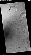
The Noachis quadrangle covers the area from 30° to 65° south latitude and 300° to 360° west longitude (60-0 E). It lies between Argyre and Hellas, two giant impact basins on Mars. The Noachis quadrangle includes Noachis Terra and the western part of Hellas Planitia, classical names for regions on Mars. Noachis is considered among the oldest regions on Mars since it is so densely covered with impact craters that ii. The oldest parts of Mars have the designation of “Noachian age." In addition, many previously buried craters are now coming to the surface.[1] Noachis' extreme age has allowed ancient craters to be filled, and once again become newly exposed. Much of the surface in Noachis quadrangle shows a scalloped topography in which the disappearance of ground ice has left depressions.[2] The first piece of human technology to land on Mars landed (crashed) in the Noachis quadrangle. It was the Soviet's Mars 2 that crash landed at 44.2 S and 313.2 W|. It weighed about one ton. The automated craft attempted to land in a giant dust storm and in an area that has many dust devils.[3]
Contents
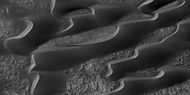
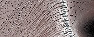
Scalloped topography

Certain regions of Mars display scalloped-shaped depressions. The depressions are believed to be the remains of an ice-rich mantle deposit. Scallops are created when ice sublimates from frozen soil.[4] [5] This mantle material probably fell from the air as ice formed on dust when the climate was different due to changes in the tilt of the Mars pole.[6] The scallops are typically tens of meters deep and from a few hundred to a few thousand meters across. They can be almost circular or elongated. Some appear to have coalesced, thereby causing a large heavily pitted terrain to form. A study published in Icarus, found that the landforms of scalloped topography can be made by the subsurface loss of water ice by sublimation under current Martian climate conditions. This model predicts similar shapes when the ground has large amounts of pure ice, up to many tens of meters in depth.[7] The process of producing the terrain may begin with sublimation from a crack because there are often polygon cracks where scallops form.[8]

Scalloped topography, as seen by HiRISE

Close view of scalloped topography, as seen by HiRISE

Scalloped topography, as seen by HiRISE under HiWish program Dust devil tracks are also visible.
Scalloped topography, as seen by HiRISE under HiWish program


Dust Devil Tracks
Many areas on Mars experience the passage of giant dust devils. A thin coating of fine bright dust covers most of the Martian surface. When a dust devil goes by it blows away the coating and exposes the underlying dark surface creating tracks. It does not take too much fine dust to cover those tracks--experiments in Earth laboratories demonstrate that only a few 10's of microns of dust will be enough. The width of a single human hair ranges from approximately 20 to 200 microns (μm); consequently, the dust that can cover dust devil tracks may only be the thickness of a human hair.[9] The pattern of the dust devil tracks have been shown to change every few months.[10] Dust devils have been seen from the ground and from orbit. They have even blown the dust off of the solar panels of the two Mars Exploration Rovers (Spirit and Opportunity), thereby greatly extending their lives.[11] The twin Rovers were designed to last for 3 months, instead they lasted many years with Opportunity lasting over 14 years. The pattern of the dust devil tracks have been shown to change every few months.[12] One study that combined data from the High Resolution Stereo Camera (HRSC) and the Mars Orbiter Camera (MOC) found that some large dust devils on Mars have a diameter of 700 meters and last at least 26 minutes.[13] The image below of Russel Crater shows changes in dust devil tracks over a period of only three months, as documented by HiRISE. Other Dust Devil Tracks are visible in the picture of Frento Vallis.

Russell Crater Dust Devil Changes, as seen by HiRISE. Click on image to see changes in dust devil tracks in just 3 months.
- Frento Vallis.JPG
Frento Vallis, as seen by HiRISE. Click on image to see better view of Dust Devil Tracks.

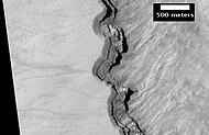
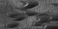
Craters
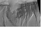
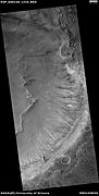
Impact craters generally have a rim with ejecta around them, in contrast volcanic craters usually do not have a rim or ejecta deposits. As craters get larger (greater than 10 km in diameter) they usually have a central peak.[14] The peak is caused by a rebound of the crater floor following the impact.[15] Sometimes craters will display layers. Craters can show us what lies deep under the surface.

Maunder Crater, as seen by HiRISE. The overhang is part of the degraded south (toward bottom) wall of crater. The scale bar is 500 meters long.

Asimov Crater, as seen by HiRISE. Bottom of picture shows southeastern wall of crater. Top of picture is edge of mound that fills most of the crater.

Layers in west slope of Asimov Crater, as seen by HiRISE.
Close-up of layers in west slope of Asimov Crater. Shadows show the overhang. Some of the layers are much more resistant to erosion, so they stick out. Image from HiRISE.

East Slope of Central Pit in Asimov Crater, as seen by HiRISE. Click on image to see more details of the many gullies.

Kaiser Crater (large crater in upper part of image)context for THEMIS image.

Detail of south wall of Kaiser Crater, as seen by THEMIS. Top of image shows part of a dune field.
- Rabe Crater Floor.JPG
Rabe Crater Floor, as seen by HiRISE. Click on image to see layers. Dark sand that made the dunes was probably blown in from elsewhere.

Crater that was buried in another age and is now being exposed by erosion, as seen by the Mars Global Surveyor, under the MOC Public Targeting Program.
Floor of crater in Noachis quadrangle, as seen by HiRISE under HiWish program.

Erosion forms on floor of crater, as seen by HiRISE under HiWish program

Le Verrier (Martian Crater), as seen by CTX camera (on Mars Reconnaissance Orbiter)


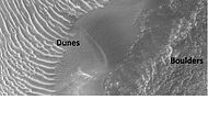
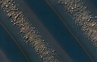
Sand Dunes
When there are perfect conditions for producing sand dunes, steady wind in one direction and just enough sand, a barchan sand dune forms. Barchans have a gentle slope on the wind side and a much steeper slope on the lee side where horns or a notch often forms.[16] One picture below shows a definite barchan.

Dark dunes (probably basalt), in an intracrater dune field, Noachis. Picture from Mars Global Surveyor, under the MOC Public Targeting Program.
Wide view of dunes in Noachis, as seen by HiRISE.
Close-up View of dunes in previous image, as seen by HiRISE. Note how sand barely covers some boulders.

Barchan sand dunes in the Hellespontus region, as seen by HiRISE. The horns point in the downwind direction.
- Proctor Crater Ripples and Dunes.JPG
Proctor Crater ripples and dunes, as seen by HiRISE.

Wide view of a field of sand dunes, as seen by HiRISE under HiWish program

Close view of sand dunes, as seen by HiRISE under HiWish program A birchen dune is labeled.
Close view of sand dunes, as seen by HiRISE under HiWish program
Close view of sand dunes, as seen by HiRISE under HiWish program A birchen dune is labeled.

Close, color view of sand dunes, as seen by HiRISE under HiWish program
Close, color view of dome sand dunes, as seen by HiRISE under HiWish program


Gullies
Gullies on steep slopes are found in certain regions of Mars. Many ideas have been advanced to explain them. Formation by running water when the climate was different is a popular idea. Recently, because changes in gullies have been seen since HiRISE has been orbiting Mars, it is thought that they may be formed by chunks of dry ice moving down slope during spring time. Gullies are one of the most interesting discoveries made by orbiting space craft.[17] [18] [19] [20]

Gullies on the wall of a crater, as seen by HiRISE under HiWish program
Gullies on mound in Asimov Crater, as seen by HiRISE


Wide view of gullies and ridges in crater, as seen by HiRISE under HiWish program

Close view of gully channels, as seen by HiRISE under HiWish program Channels make some tight curves.

Close view of gully channels, as seen by HiRISE under HiWish program Arrows point to small channel within larger channels.


Wide view of gullies, as seen by HiRISE under HiWish program

Close view of gullies, as seen by HiRISE under HiWish program Channels show curves.

Close view of gullies, as seen by HiRISE under HiWish program Polygonal shapes are visible.

Crater with gullies, as seen by HiRISE under HiWish program

Close view of gullies, as seen by HiRISE under HiWish program


Hellas floor features
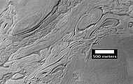
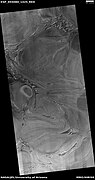
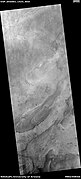
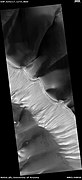
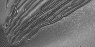
The Hellas floor contains some strange-looking features. One of these features is called "banded terrain."[21] [22] [23] This terrain has also been called "taffy pull" terrain, and it lies near honeycomb terrain, another strange surface.[24] Banded terrain is found in the north-western part of the Hellas basin. This is the deepest part of the Hellas basin. The banded-terrain deposit displays an alternation of narrow band shapes and inter-bands. The sinuous nature and relatively smooth surface texture suggesting a viscous flow origin. A study published in Planetary and Space Science found that this terrain was the youngest deposit of the interior of Hellas. They also suggest in the paper that banded terrain may have covered a larger area of the NW interior of Hellas. The bands can be classified as linear, concentric, or lobate. Bands are typically 3–15 km long, 3 km wide. Narrow inter-band depressions are 65 m wide and 10 m deep.[25] Pictures of these features can look like abstract art.

Wide view of part of the floor of the Hellas basin, as seen by CTX
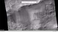
Wide view of Hellas basin floor, as seen by CTX. This is a slight enlargement of the previous image. The box shows the location of the next image that was taken with HiRISE.

Close-up of banded terrain on the floor of the Hellas basin, as seen by HiRISE Other, previous photos show wide views of this region.
Twisted Terrain in Hellas Planitia, but actually located in Noachis quadrangle. Imagine trying to walk across this. Image taken with HiRISE.


Layered features on floor of Hellas Planitia, as seen by HiRISE under HiWish program This may be an example of honeycomb terrain that is not yet completely understood.

Twisted bands on the floor of Hellas Planitia, as seen by HiRISE under HiWish program

Twisted bands on the floor of Hellas Planitia, as seen by HiRISE under HiWish program These twisted bands are also called "taffy pull" terrain.

Wide view of twisted bands on the floor of Hellas Planitia, as seen by HiRISE under HiWish program

Close view of ridges in twisted bands, as seen by HiRISE under HiWish program
Floor features in Hellas Planitia, as seen by HiRISE under HiWish program

Floor features in Hellas Planitia, as seen by HiRISE under HiWish program


Gullies on Dunes
Gullies are found on some dunes. These are somewhat different than gullies in other places, like the walls of craters. Gullies on dunes seem to keep the same width for a long distance and often just end with a pit, instead of an apron. Many of these gullies are found on dunes in Russell Crater.
Wide view of dunes in Russell Crater, as seen by HiRISE Many narrow gullies are visible.
Close view of the end of gullies in Russell Crater, as seen by HiRISE Note: These type of gullies do not usually end with an apron.

Close view of the end of gullies in Russell Crater, as seen by HiRISE
Close, color view of the end of gullies in Russell Crater, as seen by HiRISE


Channels
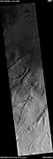
Channels, as seen by HiRISE under HiWish program

Channel, as seen by HiRISE under HiWish program


Other scenes from Noachis quadrangle

Dissected Mantle with layers, as seen by HiRISE.

Layers in depression in crater, as seen by HiRISE under HiWish program

Wide view of ridges, as seen by HiRISE under HiWish program

Close view of hollows, as seen by HiRISE under HiWish program Note: this is an enlargement of the previous image.

Ridges, as seen by HiRISE under HiWish program Note: this is an enlargement of the previous image.

High center polygons, as seen by HiRISE under HiWish program Boxes are drawn around two individual polygons.

Wide view of mounds and brain terrain, as seen by HiRISE under HiWish program

Close view of mounds and brain terrain, as seen by HiRISE under HiWish program

Light-toned material, as seen by HiRISE under HiWish program Light-toned material is often associated with minerals that formed in water.

Close view of surface, showing boulders and light-toned material, as seen by HiRISE under HiWish program

Flow, as seen by HiRISE under HiWish program

Wide view showing flows and ridges, as seen by HiRISE under HiWish program

Close view of ridges, as seen by HiRISE under HiWish program


See also
- Barchan
- Climate of Mars
- Geology of Mars
- Groundwater on Mars
- HiRISE
- Hydrothermal circulation
- Impact crater
- List of craters on Mars
- List of quadrangles on Mars
- Martian gullies
- MOC Public Targeting Program
- Ore genesis
- Ore resources on Mars
- Polygonal patterned ground
- Planetary nomenclature
- Scalloped topography
- Water on Mars
References
- ↑ http://themis.asu.edu/zoom-20040317a%7Ctitle=Exhumed Crater (Released 17 March 2004)|author=Mars Space Flight Facility|date=17 March 2004|publisher=Arizona State University|
- ↑ Lefort | first1 = A. | display-authors = etal | year = 2010 | title = Scalloped terrains in the Peneus and Amphitrites Paterae region of Mars as observed by HiRISE | url = | journal = Icarus | volume = 205 | issue = 1| pages = 259–268 |
- ↑ Hartmann, W. 2003. A Traveler's Guide to Mars. Workman Publishing. NY, NY.
- ↑ https://www.uahirise.org/PSP_004340_1235 | title=HiRISE | Scalloped Depressions in Peneus Patera (PSP_004340_1235)}}
- ↑ McEwen, A., et al. 2017. Mars The Pristine Beauty of the Red Planet. University of Arizona Press. Tucson.
- ↑ doi=10.1038/nature02114 |pmid=14685228 |title=Recent ice ages on Mars |journal=Nature |volume=426 |issue=6968 |pages=797–802 |year=2003 |last1=Head |first1=James W. |last2=Mustard |first2=John F. |last3=Kreslavsky |first3=Mikhail A. |last4=Milliken |first4=Ralph E. |last5=Marchant |first5=David R. |
- ↑ |doi=10.1016/j.icarus.2015.07.033 |title=Modeling the development of martian sublimation thermokarst landforms |journal=Icarus |volume=262 |pages=154–169 |year=2015 |last1=Dundas |first1=Colin M. |last2=Byrne |first2=Shane |last3=McEwen |first3=Alfred S. |https://zenodo.org/record/1259051/files/article.pdf
- ↑ Lefort, A.; et al. (2010). "Scalloped terrains in the Peneus and Amphitrites Paterae region of Mars as observed by HiRISE". Icarus. 205 (1): 259–268.
- ↑ https://en.wikipedia.org/wiki/Micrometre
- ↑ http://mars.jpl.nasa.gov/spotlight/KenEdgett.html |title=Ken Edgett |date=2001 |publisher=National Aeronautics and Space Administration
- ↑ http://marsrovers.jpl.nasa.gov/gallery/press/spirit/20070412a.html%7Cpublisher=National Aeronautics and Space Administration
- ↑ https://web.archive.org/web/20111028015730/http://mars.jpl.nasa.gov/spotlight/kenEdgett.html |
- ↑ doi=10.1016/j.icarus.2011.06.011 |title=Multitemporal observations of identical active dust devils on Mars with the High Resolution Stereo Camera (HRSC) and Mars Orbiter Camera (MOC) |journal=Icarus |volume=215 |issue=1 |pages=358–369 |year=2011 |last1=Reiss |first1=D. |last2=Zanetti |first2=M. |last3=Neukum |first3=G. |
- ↑ http://www.lpi.usra.edu/publications/slidesets/stones/ | title=Stones, Wind, and Ice: A Guide to Martian Impact Craters}}
- ↑ Hugh H. Kieffer|title=Mars|url=https://books.google.com/books?id=NoDvAAAAMAAJ%7Caccessdate=7 March 2011|date=1992|publisher=University of Arizona Press|isbn=978-0-8165-1257-7
- ↑ Pye|first=Kenneth|title=Aeolian Sand and Sand Dunes|year=2008|publisher=Springer|isbn=9783540859109|pages=138|
- ↑ http://www.jpl.nasa.gov/news/news.php?release=2014-226 | title=NASA Spacecraft Observes Further Evidence of Dry Ice Gullies on Mars
- ↑ http://hirise.lpl.arizona.edu/ESP_032078_1420 | title=HiRISE | Activity in Martian Gullies (ESP_032078_1420)
- ↑ http://www.space.com/26534-mars-gullies-dry-ice.html | title=Gullies on Mars Carved by Dry Ice, Not Water
- ↑ http://spaceref.com/mars/frosty-gullies-on-mars.html | title=Frosty Gullies on Mars - SpaceRef
- ↑ Diot, X., et al. 2014. The geomorphology and morphometry of the banded terrain in Hellas basin, Mars. Planetary and Space Science: 101, 118-134.
- ↑ http://www.nasa.gov/mission_pages/MRO/multimedia/20070717-2.html | title=NASA - Banded Terrain in Hellas
- ↑ http://hirise.lpl.arizona.edu/ESP_016154_1420 | title=HiRISE | Complex Banded Terrain in Hellas Planitia (ESP_016154_1420)
- ↑ Bernhardt, H., et al. 2018. THE BANDED TERRAIN ON THE HELLAS BASIN FLOOR, MARS: GRAVITY-DRIVEN FLOW NOT SUPPORTED BY NEW OBSERVATIONS. 49th Lunar and Planetary Science Conference 2018 (LPI Contrib. No. 2083). 1143.pdf
- ↑ Complex geomorphologic assemblage of terrains in association with the banded terrain in Hellas basin, Mars |journal=Planetary and Space Science |volume=121 |pages=36–52 |year=2016 |last1=Diot |first1=X. |last2=El-Maarry |first2=M.R. |last3=Schlunegger |first3=F. |last4=Norton |first4=K.P. |last5=Thomas |first5=N. |last6=Grindrod |first6=P.M. |last7=Chojnacki |first7=M. |bibcode=2016P&SS..121...36D |url=https://boris.unibe.ch/74530/1/Diot_Schlunegger.pdf
External links
- [https://www.youtube.com/watch?v=483HcpqyMNU Banded Flow Terrain in Hellas Basi


