Difference between revisions of "Mars atlas water"
| Line 1: | Line 1: | ||
<imagemap> | <imagemap> | ||
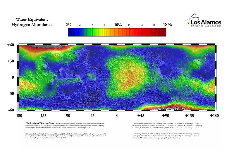
| − | File:PIA04907 Water Mass Map from Neutron Spectrometer.jpg|left|thumb|800x800px| | + | File:PIA04907 Water Mass Map from Neutron Spectrometer.jpg|left|thumb|800x800px|Water abundance from the Mars Odyssey gamma ray spectrometer |
This map shows the estimated lower limit of the water content of the upper meter of Martian soil. The estimates are derived from the hydrogen abundance measured by the neutron spectrometer component of the gamma ray spectrometer suite on NASA's Mars Odyssey spacecraft. | This map shows the estimated lower limit of the water content of the upper meter of Martian soil. The estimates are derived from the hydrogen abundance measured by the neutron spectrometer component of the gamma ray spectrometer suite on NASA's Mars Odyssey spacecraft. | ||
Revision as of 18:51, 23 January 2020
Error: No valid link was found at the end of line 4.
View a map of:
Summary This map displays the proportion of water ice present in the upper meter of the Martian surface within 60 degrees of the equator. The percentages are derived through stochiometric calculations based on epithermal neutron fluxes. These fluxes were detected by the Neutron Spectrometer aboard the 2001 Mars Odyssey spacecraft. For more information see Feldman, W. C., Prettyman, T. H., Maurice, S., et al., Global distribution of near-surface hydrogen on Mars: Journal of Geophysical Research: Planets, v. 109, E09006, doi:10.1029/2003JE002160. Date 24 July 2003, 09:41:17 Source http://mars.jpl.nasa.gov/odyssey/gallery/latestimages/20030724a.html Author Feldman, W.C., Prettyman, T.H., Maurice, S., et al., Los Alamos National Laboratory/JPL
Image credit: NASA/JPL/Feldman, W. et al.


