Difference between revisions of "Amazonis quadrangle"
m |
m |
||
| Line 28: | Line 28: | ||
<gallery class="center" widths="380px" heights="360px"> | <gallery class="center" widths="380px" heights="360px"> | ||
| − | Image:Medusae Fossae THEMIS.jpg| | + | Image:Medusae Fossae THEMIS.jpg|Medusae Fossae Formation and its location relative to Olympus Mons, as seen by THEMIS. |
Image:Medusae Fossae Remnant.jpg|Plateau made up of Medusae Fossae materials and rootless cones, as seen by [[HiRISE]] | Image:Medusae Fossae Remnant.jpg|Plateau made up of Medusae Fossae materials and rootless cones, as seen by [[HiRISE]] | ||
Image:23664medussa.jpg|Yardangs in the Medusae Fossae formation, as seen by HiRISE under [[HiWish program]]. | Image:23664medussa.jpg|Yardangs in the Medusae Fossae formation, as seen by HiRISE under [[HiWish program]]. | ||
| Line 34: | Line 34: | ||
35558 1830yardangs.jpg|Yardangs, as seen by HiRISE under HiWish program Location is near Gordii Dorsum in the Amazonis quadrangle. Note: this is an enlargement of previous image. | 35558 1830yardangs.jpg|Yardangs, as seen by HiRISE under HiWish program Location is near Gordii Dorsum in the Amazonis quadrangle. Note: this is an enlargement of previous image. | ||
35558 1830yardangsclose.jpg|Yardangs, as seen by HiRISE under HiWish program Location is near Gordii Dorsum in the Amazonis quadrangle. Note: this is an enlargement of previous image. | 35558 1830yardangsclose.jpg|Yardangs, as seen by HiRISE under HiWish program Location is near Gordii Dorsum in the Amazonis quadrangle. Note: this is an enlargement of previous image. | ||
| + | |||
WikiESP 036429 1925yardangscrater.jpg|Yardangs near a crater, as seen by HiRISE under HiWish program Location is in the Amazonis quadrangle. | WikiESP 036429 1925yardangscrater.jpg|Yardangs near a crater, as seen by HiRISE under HiWish program Location is in the Amazonis quadrangle. | ||
</gallery> | </gallery> | ||
| Line 39: | Line 40: | ||
<gallery class="center" widths="380px" heights="360px"> | <gallery class="center" widths="380px" heights="360px"> | ||
| − | |||
| − | |||
File:54784 1890yardangsclosecolor.jpg|Close, color view of yardangs, as seen by HiRISE under HiWish program Box shows size of a football field. | File:54784 1890yardangsclosecolor.jpg|Close, color view of yardangs, as seen by HiRISE under HiWish program Box shows size of a football field. | ||
</gallery> | </gallery> | ||
| Line 60: | Line 59: | ||
<gallery class="center" widths="380px" heights="360px"> | <gallery class="center" widths="380px" heights="360px"> | ||
| − | Image:Columnar jointing, Marte Vallis.jpg| | + | Image:Columnar jointing, Marte Vallis.jpg|Columnar jointing in a crater in Marte Vallis. |
Image:Parana traps.JPG|Columnar jointing on the Earth. | Image:Parana traps.JPG|Columnar jointing on the Earth. | ||
Image:Sounkyo 01 a.jpg|Columnar jointing on the Earth. | Image:Sounkyo 01 a.jpg|Columnar jointing on the Earth. | ||
| − | Image:Columnar Jointing in Yellowstone.JPG|Columnar Jointing in | + | Image:Columnar Jointing in Yellowstone.JPG|Columnar Jointing in Yellowstone National Park. |
</gallery> | </gallery> | ||
| Line 74: | Line 73: | ||
| − | [[File:PIA18381-Mars-FreshAsteroidImpact2012-Before27March-After28March.jpg|thumb|right|200px|Fresh [[asteroid]] impact on Mars {{coord|3.34|N|219.38|E|globe:Mars}} - ''before''/March 27 & ''after''/March 28, 2012 ([[Mars Reconnaissance Orbiter|MRO]]).<ref>Webster |first=Guy |last2=Brown |first2=Dwayne |title=NASA Mars Weathercam Helps Find Big New Crater |url=http://www.jpl.nasa.gov/news/news.php?release=2014-162 |date=22 May 2014 |work=[[NASA]] | + | [[File:PIA18381-Mars-FreshAsteroidImpact2012-Before27March-After28March.jpg|thumb|right|200px|Fresh [[asteroid]] impact on Mars {{coord|3.34|N|219.38|E|globe:Mars}} - ''before''/March 27 & ''after''/March 28, 2012 ([[Mars Reconnaissance Orbiter|MRO]]).<ref>Webster |first=Guy |last2=Brown |first2=Dwayne |title=NASA Mars Weathercam Helps Find Big New Crater |url=http://www.jpl.nasa.gov/news/news.php?release=2014-162 |date=22 May 2014 |work=[[NASA]]</ref>]] |
==Pedestal Craters== | ==Pedestal Craters== | ||
| Line 81: | Line 80: | ||
<gallery class="center" widths="380px" heights="360px"> | <gallery class="center" widths="380px" heights="360px"> | ||
| − | Image:Pedestal crater and streaks.jpg| | + | Image:Pedestal crater and streaks.jpg|Pedestal crater in Amazonis with Dark Slope Streaks, as seen by HiRISE. |
ESP 045462 1920pedestal.jpg|Pedestal crater with layers, as seen by HiRISE under HiWish program | ESP 045462 1920pedestal.jpg|Pedestal crater with layers, as seen by HiRISE under HiWish program | ||
File:ESP 055338 1865pedestal.jpg|Pedestal crater, as seen by HiRISE under HiWish program | File:ESP 055338 1865pedestal.jpg|Pedestal crater, as seen by HiRISE under HiWish program | ||
| Line 87: | Line 86: | ||
Image:Pedestal crater3.jpg|Pedestal craters form when the ejecta from impacts protect the underlying material from erosion. As a result of this process, craters appear perched above their surroundings. | Image:Pedestal crater3.jpg|Pedestal craters form when the ejecta from impacts protect the underlying material from erosion. As a result of this process, craters appear perched above their surroundings. | ||
Image:Pedestaldrawingcolor2.jpg|Drawing shows a later idea of how some pedestal craters form. In this way of thinking, an impacting projectile goes into an ice-rich layer—but no further. Heat and wind from the impact hardens the surface against erosion. This hardening can be accomplished by the melting of ice which produces a salt/mineral solution thereby cementing the surface. | Image:Pedestaldrawingcolor2.jpg|Drawing shows a later idea of how some pedestal craters form. In this way of thinking, an impacting projectile goes into an ice-rich layer—but no further. Heat and wind from the impact hardens the surface against erosion. This hardening can be accomplished by the melting of ice which produces a salt/mineral solution thereby cementing the surface. | ||
| − | + | ||
| − | Image:Pettit Crater Rim.JPG| | + | Image:Pettit Crater Rim.JPG|Pettit Crater rim, as seen by HiRISE |
| − | Image:Nicholson Crater Mound.JPG|Nicholson mound with dark streaks, as seen by HiRISE | + | Image:Nicholson Crater Mound.JPG|Nicholson mound with dark streaks, as seen by HiRISE Nicholson Crater sits right on the equator. |
</gallery> | </gallery> | ||
| Line 101: | Line 100: | ||
36745 1905lridgesshort.jpg|Close-up of ridge network, as seen by HiRISE under HiWish program This is an enlargement of a previous image. | 36745 1905lridgesshort.jpg|Close-up of ridge network, as seen by HiRISE under HiWish program This is an enlargement of a previous image. | ||
36745 1905ridgesx.jpg|Close-up of ridge network, as seen by HiRISE under HiWish program This is an enlargement of a previous image. | 36745 1905ridgesx.jpg|Close-up of ridge network, as seen by HiRISE under HiWish program This is an enlargement of a previous image. | ||
| − | + | ||
| − | |||
</gallery> | </gallery> | ||
<gallery class="center" widths="380px" heights="360px"> | <gallery class="center" widths="380px" heights="360px"> | ||
| − | |||
| − | |||
| − | |||
| − | |||
| − | + | ||
| + | |||
ESP 047611 1915closecolor.jpg|Close, color view of polygonal ridges, as seen by HiRISE under HiWish program | ESP 047611 1915closecolor.jpg|Close, color view of polygonal ridges, as seen by HiRISE under HiWish program | ||
| Line 152: | Line 147: | ||
Image:2764streaks.jpg|Image indicates crater cluster and curved lines formed by airblast from meteorites. Meteorites caused airblast which caused dust avalanches on steep slopes. Image is from HiRISE. | Image:2764streaks.jpg|Image indicates crater cluster and curved lines formed by airblast from meteorites. Meteorites caused airblast which caused dust avalanches on steep slopes. Image is from HiRISE. | ||
ESP 046583 1960mesa.jpg|Mesa with dark slope streaks, as seen by HiRISE under HiWish program | ESP 046583 1960mesa.jpg|Mesa with dark slope streaks, as seen by HiRISE under HiWish program | ||
| − | + | ||
</gallery> | </gallery> | ||
| Line 160: | Line 155: | ||
<gallery class="center" widths="380px" heights="360px"> | <gallery class="center" widths="380px" heights="360px"> | ||
| − | + | ||
| − | 45133 1970lavascalebottom.jpg| | + | 45133 1970lavascalebottom.jpg|Streamlined island showing layers, as seen by HiRISE under HiWish program |
45133 1970lvarafts.jpg|Close view of lava rafts from previous images, as seen by HiRISE under HiWish program | 45133 1970lvarafts.jpg|Close view of lava rafts from previous images, as seen by HiRISE under HiWish program | ||
| − | Image:Marte Vallis Island.JPG|Streamlined Island in | + | Image:Marte Vallis Island.JPG|Streamlined Island in Marte Vallis, as seen by HiRISE. Island is just to the west of Pettit Crater. Scale bar is 500 meters long. |
| − | Image:ESP 035480 2015streamlined.jpg|Streamlined shape showing layers, as seen by HiRISE under HiWish program | + | Image:ESP 035480 2015streamlined.jpg|Streamlined shape showing layers, as seen by HiRISE under [[HiWish program]] |
| − | + | ||
| − | + | ||
| − | + | ||
| − | + | ||
ESP 046478 1975streamlined.jpg|Streamlined feature, as seen by HiRISE under HiWish program | ESP 046478 1975streamlined.jpg|Streamlined feature, as seen by HiRISE under HiWish program | ||
</gallery> | </gallery> | ||
| Line 184: | Line 179: | ||
47137 2075layersclose.jpg|Close view of layers, as seen by HiRISE under HiWish program. | 47137 2075layersclose.jpg|Close view of layers, as seen by HiRISE under HiWish program. | ||
ESP 045198 1900craterlayers.jpg|Wide view of scarp showing layers, as seen by HiRISE under HiWish program | ESP 045198 1900craterlayers.jpg|Wide view of scarp showing layers, as seen by HiRISE under HiWish program | ||
| − | + | ||
ESP 045435 2055troughlayers.jpg|Layers in trough and dark slope streaks, as seen by HiRISE under HiWish program | ESP 045435 2055troughlayers.jpg|Layers in trough and dark slope streaks, as seen by HiRISE under HiWish program | ||
| − | |||
| − | + | ||
| + | |||
File:ESP 053795 1905layers.jpg|Layered mesas, as seen by HiRISE under HiWish program | File:ESP 053795 1905layers.jpg|Layered mesas, as seen by HiRISE under HiWish program | ||
| − | + | ||
| − | + | ||
</gallery> | </gallery> | ||
| Line 206: | Line 201: | ||
<gallery class="center" widths="380px" heights="360px"> | <gallery class="center" widths="380px" heights="360px"> | ||
| − | Image:Map of Amazonis.JPG|Map of Amazonis quadrangle. | + | Image:Map of Amazonis.JPG|Map of Amazonis quadrangle. Green rectangles are places that were imaged by the high resolution camera on the mars Global Surveyor. Notice Nicholson crater at the bottom--it sits right at the equator. |
| + | |||
Image:23664medussa.jpg|Yardangs in the Medusae Fossae formation, as seen by HiRISE under [[HiWish program]]. | Image:23664medussa.jpg|Yardangs in the Medusae Fossae formation, as seen by HiRISE under [[HiWish program]]. | ||
| − | + | ||
| − | + | ||
Image:Channels From Fissure.JPG|Channels From Fissure, as seen by HiRISE. The fissure probably started the water flowing to make the channel. The channels look somewhat better in the enlarged view of the original image. | Image:Channels From Fissure.JPG|Channels From Fissure, as seen by HiRISE. The fissure probably started the water flowing to make the channel. The channels look somewhat better in the enlarged view of the original image. | ||
| − | Image:ESP_024997ridges.jpg|Possible inverted stream channels in | + | Image:ESP_024997ridges.jpg|Possible inverted stream channels in Phlegra Dorsa region, as seen by HiRISE under [[HiWish program]]. The ridges were probably once stream valleys that have become full of sediment and cemented. So, they became hardened against erosion which removed surrounding material. |
| − | + | ||
</gallery> | </gallery> | ||
Revision as of 09:48, 11 March 2020
| MC-08 | Amazonis | 0–30° N | 135–180° W | Quadrangles | Atlas |

Amazonis quadrangle elevations


This area is considered to be among the youngest parts of Mars because it has a very low density of craters. The Amazonia period is named after this area. This quadrangle contains special, unusual features called the Medusae Fossae Formation and Sulci. As per the rest of Mars, this region contains some very beautiful landscapes. The Amazonis quadrangle is one of a series of 30 quadrangle maps of Mars used by the United States Geological Survey (USGS) . The Amazonis quadrangle is also referred to as MC-8 (Mars Chart-8).[1] The quadrangle covers the area from 0° to 30° north latitude and 135° to 180° west longitude (225-180 E ). The Amazonis quadrangle contains the region called Amazonis Planitia.
Contents
Name
Its name derives from the mythical land of the Amazons. In Greek mythology, the Amazons were a tribe of warrior women believed to live in Asia Minor. In this myth, amazons were the daughters of Ares and Harmonia (mythology) (a nymph of the Akmonian Wood). They were brutal and aggressive--their main concern in life was war.[2] [3]
Medusae Fossae Formation
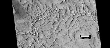
The Amazonis quadrangle is of great interest to scientists because it contains a major part of a formation, called the Medusae Fossae Formation. This unit is a soft, easily eroded deposit that extends for nearly 1,000 km along the equator of Mars. The surface of the formation has been eroded by the wind into a series of linear ridges called yardangs. These ridges generally point in direction of the prevailing winds that carved them and demonstrate the erosive power of Martian winds. The easily eroded nature of the Medusae Fossae Formation suggests that it is composed of weakly cemented particles,[4] and was most likely formed by the deposition of wind-blown dust or volcanic ash. Using a global climate model, a group of researchers concluded that the Medusae Fossae Formation could have easily been formed from ash from the volcanoes Apollinaris Mons, Arsia Mons, and possibly from Pavonis Mons.[5] Another evidence for a fine-grained composition is that the area gives almost no radar return. For this reason it has been called a "stealth" region.[6] Layers are seen in parts of the formation. Images from spacecraft show that they have different degrees of hardness probably because of significant variations in the physical properties, composition, particle size, and/or cementation. Very few impact craters are visible throughout the area so the surface is relatively young.[7] Researchers found that nearly all the dust that falls out of the atmosphere and that coats everything on Mars has its origin in the Medusae Fossae formation.[8] It turns out that the chemical elements (sulfur and chlorine) in this formation, in the atmosphere, and covering the surface are the same. The amount of dust on Mars is sufficient to form a 2 to 12 meters thick layer over the entire planet.[9] [10] Since there are relatively few depositional features in the Medusae Fossae Formation, most of the materials being eroded are probably small enough to be suspended in the atmosphere and transported long distances.[11]
An analysis of data from the 2001 Mars Odyssey Neutron Spectrometer revealed that portions of the Medusae Fossae Formation contain water.[12]

Medusae Fossae Formation and its location relative to Olympus Mons, as seen by THEMIS.
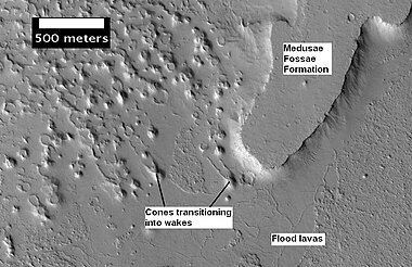
Plateau made up of Medusae Fossae materials and rootless cones, as seen by HiRISE

Yardangs in the Medusae Fossae formation, as seen by HiRISE under HiWish program.
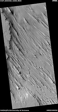
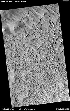
Yardangs, as seen by HiRISE under HiWish program Location is near Gordii Dorsum in the Amazonis quadrangle. These yardangs are in the upper member of the Medusae Fossae Formation.
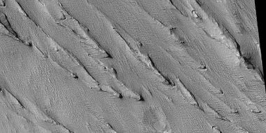
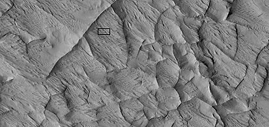
Yardangs, as seen by HiRISE under HiWish program Location is near Gordii Dorsum in the Amazonis quadrangle. Note: this is an enlargement of previous image.

Yardangs, as seen by HiRISE under HiWish program Location is near Gordii Dorsum in the Amazonis quadrangle. Note: this is an enlargement of previous image.
Yardangs near a crater, as seen by HiRISE under HiWish program Location is in the Amazonis quadrangle.


Close, color view of yardangs, as seen by HiRISE under HiWish program Box shows size of a football field.

Sulci
A very rugged terrain extends from the base of Olympus Mons, the largest volcano on Mars. This terrain is called Lycus Sulci. Sulci is a Latin term for the furrows on the surface of a brain, so Lycus Sulci has many furrows or grooves. The furrows are huge—up to a full kilometer deep.[13] It would be extremely difficult to walk across it or to land a space ship there. A picture of this area is shown below.

Sulci in Amazonis, as seen by THEMIS. "Sulci" in Mars geography language means a furrow, like a furrow on a brain's surface. This Sulci came from the basal scarp of Olympus Mons

Layered features in Lycus Sulci, as seen by HiRISE under HiWish program

Dark slope streaks on mound in Lycus Sulci, as seen by HiRISE under HiWish program


Columnar Jointing
Lava flows sometimes cools to form large groups of more-or-less equally sized columns.[14] Since Mars is largely covered by lava flow, it was expected that these joints were on Mars. With the superior resolution of the HiRISE images, scientists finally found columnar jointing in various locations in 2009. Pictures below show examples of columnar jointing both on Mars and on the Earth. Many tourists travel to see these formations in our National Parks, like Yellowstone.

Columnar jointing in a crater in Marte Vallis.

Columnar jointing on the Earth.

Columnar jointing on the Earth.

Columnar Jointing in Yellowstone National Park.


Craters
Craters give us insight into what lies under the ground. Since the collision that produces an impact crater is like a powerful explosion, rocks from deep underground are tossed onto the surface. Hence, by examining the material or ejecta thrown out by the impact, we can see what lies deep under the surface. Some craters, especially the more recent ones, will display layers on their walls. These layers can help us tell the kinds of rocks that were formed in the past. For example, layers that contain dark, blocky boulders likely originated as lava flows. As craters get larger (greater than 10 km in diameter) they usually have a central peak.[15] The peak is caused by a rebound of the crater floor following the impact.[16] Scientists are eager to examine those central peaks because they contain samples of rocks from deep underground. Instruments, called spectroscopes, can tell us the mineral composition of these rocks. We believe that pits in Tooting Crater are caused by hot ejecta falling on ground containing ice. The pits are formed by heat forming steam that rushes out from groups of pits simultaneously, thereby blowing away from the pit ejecta.[17][18]

Pedestal Craters
A pedestal crater is an impact crater with its ejecta sitting on a raised platform above the surrounding terrain. They form when an impact crater ejects material which forms an erosion resistant layer, thus protecting the immediate area from erosion. As a result of this hard covering, the crater and its ejecta become elevated, after erosion removes the softer material beyond the ejecta. Some pedestals have been accurately measured to be hundreds of meters above the surrounding area. This means that hundreds of meters of material were eroded away. Pedestal craters were first observed during the Mariner missions.[20] [21]

Pedestal crater in Amazonis with Dark Slope Streaks, as seen by HiRISE.

Pedestal crater with layers, as seen by HiRISE under HiWish program

Pedestal crater, as seen by HiRISE under HiWish program

Pedestal craters form when the ejecta from impacts protect the underlying material from erosion. As a result of this process, craters appear perched above their surroundings.
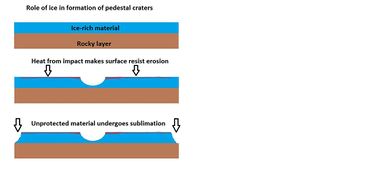
Drawing shows a later idea of how some pedestal craters form. In this way of thinking, an impacting projectile goes into an ice-rich layer—but no further. Heat and wind from the impact hardens the surface against erosion. This hardening can be accomplished by the melting of ice which produces a salt/mineral solution thereby cementing the surface.

Pettit Crater rim, as seen by HiRISE

Nicholson mound with dark streaks, as seen by HiRISE Nicholson Crater sits right on the equator.


Linear ridge networks
Linear ridge networks are found in various places on Mars in and around craters.[22] Ridges often appear as mostly straight segments that intersect in a lattice-like manner. They are hundreds of meters long, tens of meters high, and several meters wide. There origin is not completely understood. One idea for their origin is that impacts created fractures in the surface, these fractures later acted as channels for fluids. Fluids turned into hard ridges. With the passage of time, surrounding material was eroded away, thereby leaving hard ridges behind. Since the ridges occur in locations with clay, these formations could serve as a marker for clay which requires water for its formation.[23] [24] [25] Water here could have supported past life in these locations. Clay may also preserve fossils or other traces of past life.

Narrow ridges, as seen by HiRISE under HiWish program. The ridges may be the result of impacts fracturing the surface.
Linear ridge networks, as seen by HiRISE under HiWish program

Close-up of ridge network, as seen by HiRISE under HiWish program This is an enlargement of a previous image.

Close-up of ridge network, as seen by HiRISE under HiWish program This is an enlargement of a previous image.


Close, color view of polygonal ridges, as seen by HiRISE under HiWish program

Wide view of large ridge network, as seen by HiRISE under HiWish program
Close view of ridge network, as seen by HiRISE under HiWish program Box shows size of football field.

Close view of contact between ridge network and overlying layer, as seen by HiRISE under HiWish program

Close, color view of ridges, as seen by HiRISE under HiWish program


Dark Slope Streaks
Dark slope streaks are narrow, avalanche-like features common on dust-covered slopes in the equatorial regions.[26] They form in relatively steep sites, such as along escarpments and impact crater walls.[27] Although first recognized in Viking Orbiter images from the late 1970s,[28] [29] dark slope streaks were not studied in detail until higher-resolution images from the Mars Global Surveyor (MGS) and Mars Reconnaissance Orbiter (MRO) spacecraft became available in the late 1990s and 2000s.[30] [31]
The physical process that produces dark slope streaks is still uncertain. They are most likely caused by the mass movement of loose, fine-grained material on oversteepened slopes (i.e., dust avalanches).[32][33] The avalanching disturbs and removes a bright surface layer of dust to expose a darker substrate.[34]

Dark slope streaks on layered mesa, as seen by HiRISE under HiWish program

Dark slope streaks on mesa, as seen by HiRISE under HiWish program Location is Amazonis quadrangle.

Layers in Gordii Dorsum Region, as seen by HiRISE under HiWish program. Dark lines are Dark Slope Streaks.


Research, published in January 2012 in Icarus, found that dark streaks were initiated by airblasts from meteorites traveling at supersonic speeds. The team of scientists was led by Kaylan Burleigh, an undergraduate at the University of Arizona. After counting some 65,000 dark streaks around the impact site of a group of 5 new craters, the team of scientists saw patterns. The number of streaks was greatest closer to the impact site. So, the impact somehow probably caused the streaks. Also, the distribution of the streaks formed a pattern with two wings extending from the impact site. The curved wings resembled curved knives, called scimitars. This pattern suggests that an interaction of airblasts from the group of meteorites shook dust loose enough to start dust avalanches that formed the streaks. At first it was thought that the shaking of the ground from the impact caused the dust avalanches, but if that was the case the dark streaks would have been arranged symmetrically around the impacts, rather than being concentrated into curved shapes. The crater cluster lies near the equator 510 miles south of Olympus Mons, on a type of terrain called the Medusae Fossae formation. The formation is coated with dust and contains wind-carved ridges called yardangs. Yardangs have steep slopes thickly covered with dust, so when the sonic boom of the airblast arrived from the impacts dust started to move down slopes. Using photos from Mars Global Surveyor and HiRISE camera on NASA's Mars Reconnaissance Orbiter, scientists have found about 20 new impacts each year on Mars. Because the spacecraft have been imaging Mars almost continuously for a span of 14 years, newer images with suspected recent craters can be compared to older images to determine when the craters were formed. Since the craters were spotted in a HiRISE image from February 2006, but were not present in a Mars Global Surveyor image taken in May 2004, the impact occurred in that time frame. The largest crater in the cluster is about 22 meters (72 feet) in diameter--close to the area of a basketball court. As the meteorite traveled through the Martian atmosphere it probably broke up; hence a tight group of impact craters resulted. Dark slope streaks have been seen for some time, and many ideas have been advanced to explain them. This research may have finally solved this mystery.[35][36] [37]

Image indicates crater cluster and curved lines formed by airblast from meteorites. Meteorites caused airblast which caused dust avalanches on steep slopes. Image is from HiRISE.

Mesa with dark slope streaks, as seen by HiRISE under HiWish program


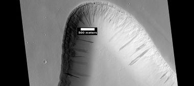
Streamlined shapes
When a fluid moves by a feature like a mound, it will become streamlined. Often flowing water makes the shape and later lava flows spread over the region. In the pictures below this has occurred.

Streamlined island showing layers, as seen by HiRISE under HiWish program
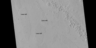
Close view of lava rafts from previous images, as seen by HiRISE under HiWish program

Streamlined Island in Marte Vallis, as seen by HiRISE. Island is just to the west of Pettit Crater. Scale bar is 500 meters long.

Streamlined shape showing layers, as seen by HiRISE under HiWish program

Streamlined feature, as seen by HiRISE under HiWish program


Layers
Many places on Mars show rocks arranged in layers. Rock can form layers in a variety of ways. Volcanoes, wind, or water can produce layers.[38] A detailed discussion of layering with many Martian examples can be found in Sedimentary Geology of Mars.[39] Sometimes the layers are of different colors. Light-toned rocks on Mars have been associated with hydrated minerals like sulfates. The Mars Rover Opportunity examined such layers close-up with several instruments. Some layers are made up of fine particles because they seem to break up into find dust. Other layers break up into large boulders so they are probably much harder. Basalt, a volcanic rock, is thought to in the layers that form boulders. Basalt has been identified on Mars in many places. Instruments on orbiting spacecraft have detected clay (also called phyllosilicate) in some layers. Finding clay is important because it has to have water to form. Evidence of past life may be found in clay deposits. A detailed discussion of layering with many Martian examples can be found in Sedimentary Geology of Mars.[40] Layers can be hardened by the action of groundwater. Martian ground water probably moved hundreds of kilometers, and in the process it dissolved many minerals from the rock it passed through. When ground water surfaces in low areas containing sediments, water evaporates in the thin atmosphere and leaves behind minerals as deposits and/or cementing agents. Consequently, layers of dust could not later easily erode away since they were cemented together.

Wide view of layers, as seen by HiRISE under HiWish program.

Close view of layers, as seen by HiRISE under HiWish program.

Wide view of scarp showing layers, as seen by HiRISE under HiWish program
Layers in trough and dark slope streaks, as seen by HiRISE under HiWish program
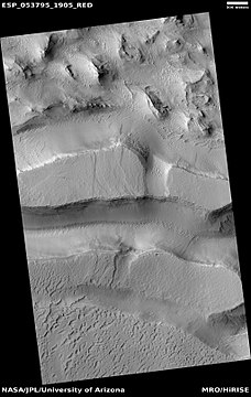
Layered mesas, as seen by HiRISE under HiWish program


Dust devils
Dust devil tracks can be very pretty. They are caused by giant dust devils removing bright colored dust from the Martian surface; thereby exposing a dark layer. Dust devils on Mars have been photographed both from the ground and high overhead from orbit. They have even blown dust off the solar panels of two Rovers on Mars, thereby greatly extending their useful lifetime.[41] The pattern of tracks has been shown to change every few months.[42] A study that combined data from the High Resolution Stereo Camera (HRSC) and the Mars Orbiter Camera (MOC) found that some large dust devils on Mars have a diameter of 700 m and last at least 26 minutes.[43]

A dust devil on hilly terrain in the Amazonis region.

More images from Amazonis quadrangle

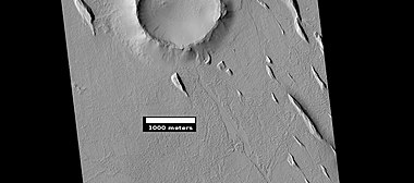
Map of Amazonis quadrangle. Green rectangles are places that were imaged by the high resolution camera on the mars Global Surveyor. Notice Nicholson crater at the bottom--it sits right at the equator.
Yardangs in the Medusae Fossae formation, as seen by HiRISE under HiWish program.
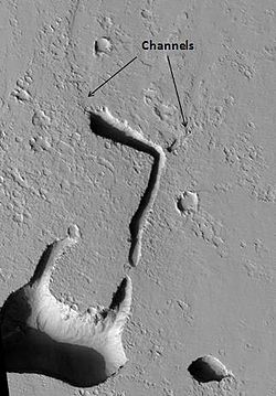
Channels From Fissure, as seen by HiRISE. The fissure probably started the water flowing to make the channel. The channels look somewhat better in the enlarged view of the original image.

Possible inverted stream channels in Phlegra Dorsa region, as seen by HiRISE under HiWish program. The ridges were probably once stream valleys that have become full of sediment and cemented. So, they became hardened against erosion which removed surrounding material.


Lava flows affected by obstacles, as seen by HiRISE under HiWish program Arrows show two obstacles that are changing the flow.

View of a lava lobe, as seen by HiRISE under HiWish program The box shows the size of a football field.

Close view of a lava lobe, as seen by HiRISE under HiWish program The box shows the size of a football field.


See also
- Dark slope streaks
- High Resolution Imaging Science Experiment (HiRISE)
- HiWish program
- How are features on Mars Named?
- Layers on Mars
- Mars Global Surveyor
- Martian gullies
- Rivers on Mars
References
- ↑ Davies, M.E.; Batson, R.M.; Wu, S.S.C. "Geodesy and Cartography" in Kieffer, H.H.; Jakosky, B.M.; Snyder, C.W.; Matthews, M.S., Eds. Mars. University of Arizona Press: Tucson, 1992.
- ↑ https://www.theoi.com/Olympios/AresFamily.html#Amazones Apollonius Rhodius, Argonautica (Book 2, ln. 989)]
- ↑ http://sacred-texts.com/cla/argo/argo23.htm ARGONAUTICA, BOOK 2
- ↑ Grotzinger, J. and R. Milliken (eds.) 2012. Sedimentary Geology of Mars. SEPM
- ↑ Kerber L., et al. 2012. The disporsal of pyroclasts from ancient explosive volcanoes on Mars: Implications for the friable layered deposits. Icarus. 219:358-381.
- ↑ ISBN 978-0-521-85226-5
- ↑ http://themis.asu.edu/zoom-20020416a
- ↑ http://redplanet.asu.edu/?tag=medusae-fossae-formation
- ↑ https://www.sciencedaily.com/releases/2018/07/180724120854.htm
- ↑ Lujendra Ojha, Kevin Lewis, Suniti Karunatillake, Mariek Schmidt. The Medusae Fossae Formation as the single largest source of dust on Mars. Nature Communications, 2018; 9 (1) DOI: 10.1038/s41467-018-05291-5
- ↑ Tanaka, K. L. Dust and ice deposition in the Martian geologic record. Icarus 144, 254–266 (2000).
- ↑ Wilson, J. et al. 2018. Equatorial locations of water on Mars: Improved resolution maps based on Mars Odyssey Neutron Spectrometer data. Icarus: 299, 148-160.
- ↑ http://themis.asu.edu/zoom-20030606a
- ↑ http://volcano.oregonstate.edu/columnar-jointing
- ↑ http://www.lpi.usra.edu/publications/slidesets/stones/
- ↑ {{cite book|author=Hugh H. Kieffer|title=Mars|url=https://books.google.com/books?id=NoDvAAAAMAAJ%7Caccessdate=7 March 2011|date=1992|publisher=University of Arizona Press|isbn=978-0-8165-1257-7
- ↑ Boyce, J. et al. 2012. Origin of small pits in martian impact craters. Icarus. 221: 262-275.
- ↑ Tornabene, L. et al. 2012. Widespread crater-related pitted materials on Mars. Further evidence for the role of target volatiles during the impact process. Icarus. 220: 348-368.
- ↑ Webster |first=Guy |last2=Brown |first2=Dwayne |title=NASA Mars Weathercam Helps Find Big New Crater |url=http://www.jpl.nasa.gov/news/news.php?release=2014-162 |date=22 May 2014 |work=NASA
- ↑ Bleacher, J. and S. Sakimoto. Pedestal Craters, A Tool For Interpreting Geological Histories and Estimating Erosion Rates. LPSC
- ↑ http://themis.asu.edu/feature/8
- ↑ Head, J., J. Mustard. 2006. Breccia dikes and crater-related faults in impact craters on Mars: Erosion and exposure on the floor of a crater 75 km in diameter at the dichotomy boundary, Meteorit. Planet Science: 41, 1675-1690.
- ↑ Mangold et al. 2007. Mineralogy of the Nili Fossae region with OMEGA/Mars Express data: 2. Aqueous alteration of the crust. J. Geophys. Res., 112, doi:10.1029/2006JE002835.
- ↑ Mustard et al., 2007. Mineralogy of the Nili Fossae region with OMEGA/Mars Express data: 1. Ancient impact melt in the Isidis Basin and implications for the transition from the Noachian to Hesperian, J. Geophys. Res., 112.
- ↑ Mustard et al., 2009. Composition, Morphology, and Stratigraphy of Noachian Crust around the Isidis Basin, J. Geophys. Res., 114, doi:10.1029/2009JE003349.
- ↑ Chuang, F.C.; Beyer, R.A.; Bridges, N.T. (2010). Modification of Martian Slope Streaks by Eolian Processes. Icarus, 205 154–164.
- ↑ Schorghofer, N.; Aharonson, O.; Khatiwala, S. (2002). Slope Streaks on Mars: Correlations with Surface Properties and the Potential Role of Water. Geophys. Res. Lett., 29(23), 2126,
- ↑ Morris, E.C. (1982). Aureole Deposits of the Martian Volcano Olympus Mons. J. Geophys. Res., 87(B2), 1164–1178.
- ↑ Ferguson,H.M.; Lucchitta, B.K. (1984). Dark Streaks on Talus Slopes, Mars in Reports of the Planetary Geology Program 1983, NASA Tech. Memo., TM-86246, pp. 188–190. https://ntrs.nasa.gov/archive/nasa/casi.ntrs.nasa.gov/19840015363_1984015363.pdf.
- ↑ Sullivan, R. et al. (2001). Mass Movement Slope Streaks Imaged by the Mars Orbiter Camera. J. Geophys. Res., 106(E10), 23,607–23,633.
- ↑ Chuang, F.C. et al. 2007. HiRISE Observations of Slope Streaks on Mars. Geophys. Res. Lett., 34 L20204,
- ↑ Sullivan, R.; Daubar, I.; Fenton, L.; Malin, M.; Veverka, J. (1999). Mass-Movement Considerations for Dark Slope Streaks Imaged by the Mars Orbiter Camera. 30th Lunar and Planetary Science Conference, Abstract #1809. http://www.lpi.usra.edu/meetings/LPSC99/pdf/1809.pdf.
- ↑ Barlow, 2008, p. 141.
- ↑ Ferris, J. C.; Dohm, J.M.; Baker, V.R.; Maddock III, T. (2002). Dark Slope Streaks on Mars: Are Aqueous Processes Involved? Geophys. Res. Lett., 29(10), 1490, . http://www.agu.org/journals/ABS/2002/2002GL014936.shtml.
- ↑ Kaylan J. Burleigh, Henry J. Melosh, Livio L. Tornabene, Boris Ivanov, Alfred S. McEwen, Ingrid J. Daubar. Impact air blast triggers dust avalanches on Mars" Icarus 2012; 217 (1) 194
- ↑ http://redplanet.asu.edu/
- ↑ http://phys.org/news/2011-12-meteorite-shockwaves-trigger-avalanches-mars.html
- ↑ http://hirise.lpl.arizona.edu?PSP_008437_1750 |title=HiRISE | High Resolution Imaging Science Experiment |publisher=Hirise.lpl.arizona.edu?psp_008437_1750 |
- ↑ Grotzinger, J. and R. Milliken (eds.). 2012. Sedimentary Geology of Mars. SEPM.
- ↑ Grotzinger, J. and R. Milliken (eds.). 2012. Sedimentary Geology of Mars. SEPM.
- ↑ http://marsrovers.jpl.nasa.gov/gallery/press/spirit/20070412a.html Mars Exploration Rover Mission: Press Release Images: Spirit. Marsrovers.jpl.nasa.gov. Retrieved on 7 August 2011.
- ↑ http://hirise.lpl.arizona.edu/PSP_005383_1255
- ↑ Reiss, D. et al. 2011. Multitemporal observations of identical active dust devils on Mars with High Resolution Stereo Camera (HRSC) and Mars Orbiter Camera (MOC). Icarus. 215:358-369.


